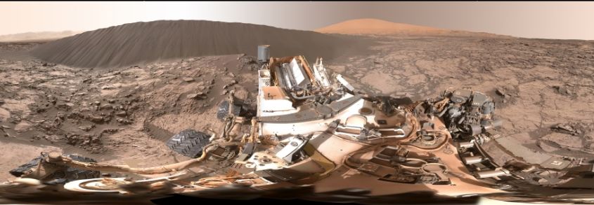
 NASA’s Mar Science Laboratory rover, Curiosity, continues to perform the first up-close study ever conducted of extraterrestrial sand dunes as it slowly explores the slopes of “Mount Sharp” dubbed the “Bagnold Dunes”.
Located on the north-west slope of the mound which lies at the centre of Gale Crater, the dunes differ from those drifts and sand fields the rover has previously encountered on Mars in terms of both their size and height – some cover an area the size of a football field and are 2 storeys high – and their general shape, something which marks them out as “classic” sand dunes.
This latter point is most evident by the dunes exhibiting a steep, downwind slope, referred to as the slip face, and which exhibits certain features of its own, such as gain fall, ripples and grain flow, as well as the dune as a whole exhibiting typical features such as the horn and toe.
For the last couple of weeks, the rover has been working its way around one dune in particular, dubbed “Namib”, which is somewhat smaller than the “high dunes” images at the start of December, but which still rises to a height of some 5 metres (16 ft). The leeward side of “Namib” in particular demonstrates the classic features of a sand dune, and helps to confirm the fact that the dunes are slowly progressing down the slope of “Mount Sharp” at a rate of about 1 metre (39 inches) a year.

The dune-investigation campaign is designed to increase understanding about how wind moves and sorts grains of sand in an environment with less gravity and much less atmosphere than well-studied dune fields on Earth. Such an understanding of how the wind moves sand could lead to a clearer picture of how big a role the Martian wind played in depositing concentrations of minerals often associated with water across the planet, and by extension, the behaviour and disposition of liquid water across Mars.
Back to Sea for SpaceX
SpaceX, the private space launch company, is keeping itself busy. Following the successful launch of the Orbcomm mission from Florida’s Cape Canaveral Air force Station, together with the successful recovery of the first stage of the booster when it flew back to the Cape and performed a flawless vertical landing, the company’s next launch is scheduled for Sunday, January 17th.
The launch will take place from Vandenberg Air force Base, California, which is the company’s Pacific Coast launch operations centre. The primary aim of the mission is to place the third in a series of joint U.S.-European satellites into a near-polar orbit (for which Vandenberg AFB is ideally suited, as a polar launch from there does not pass over inhabited land during ascent, lessening the risk to human lives should a launch vehicle suffer a failure).
The Jason-3 series of missions is part of a very long-term series of studies (started in 1992) to study the topography of the ocean surface (i.e. the formation and movement of waves and the troughs between them), which can provide scientists with critical information about circulation patterns in the ocean, and about both global and regional changes in sea level and the climate implications of a warming world.
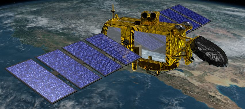
The polar orbit used for this kind of earth-observing mission, being almost perpendicular to the Earth’s rotation, allows the spacecraft to at some point travel over almost every part of the world’s oceans, vastly increasing its ability to gather data when compared to a vehicle in an equatorial orbit.
What is also significant about the mission is that it will use a SpaceX Falcon 9 1.1 booster, the first stage of which will once again attempt to return to Earth and make a safe landing. However, unlike the December 2015, this landing will once again be at sea, using a SpaceX droneship landing platform.
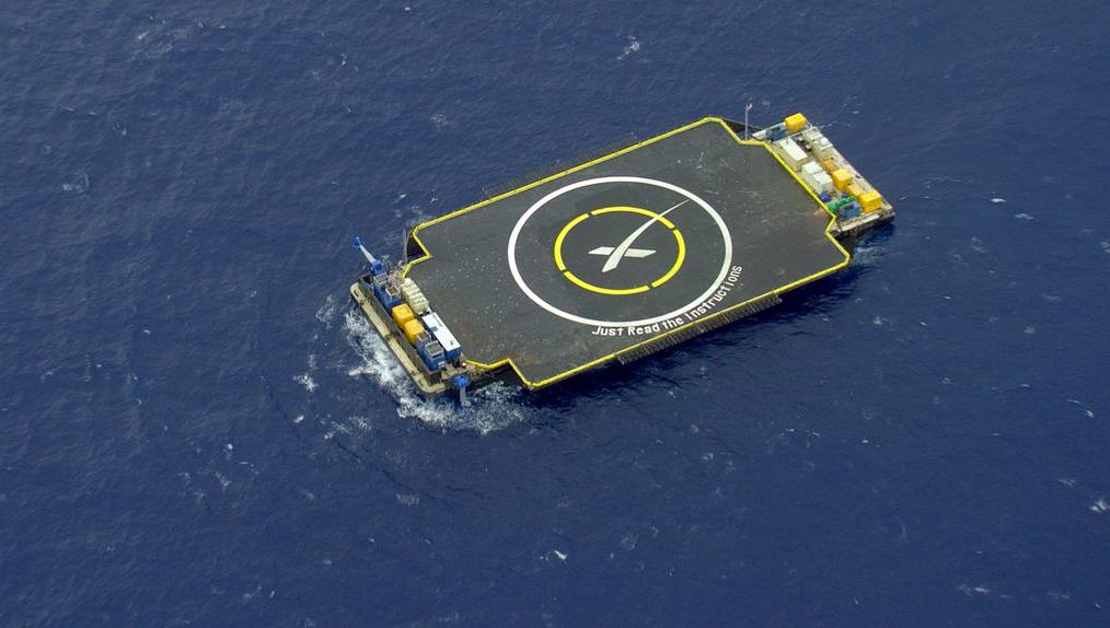
The company so far hasn’t fared well with attempts to land a Falcon 9 first stage on the droneship, with 3 previous attempts ending in the loss of the booster stage (but not the droneship). The at-sea landing is required, as SpaceX do not yet have a viable landing site for returning rockets on the US west coast.
Ice Skates on Pluto
The New Horizons space probe transmitted a special Christmas gift to Earth on December 24th, 2015. In a set of images take of the very heart of “Sputnik Planum”, the massive, low-lying region covered by a mixture of relatively young ices the probe reveals the ice to be made up of a series of plate-like cells, which but against one another with relatively smooth surfaces when compared to the rest of their pock-marked faces.
From 16 to 38 km (10 to 24 mi) across, these cells are thought to be the result of subsurface convection currents which are slowly moving the ice around, stirring it like slow-moving lumps of wax in a lava lamp, the ice rising towards the centre of the cells, and then being pushed back down along the edges where they meet. If correct, the motion further indicate that Pluto somehow has a weak, but still working, internal heat source, something scientists never expected to find in an object of this size.
Within and between the cells capture in the images, which were taken at the LORRI instrument’s highest resolution of 75 metres per pixel, large sooty black object can be seen. It is believed these are dirty icebergs of water ice “floating” in, or skating through, the much denser nitrogen ice, which is the primary component of the “Sputnik Planum” ice.

NASA Opens Planetary Defence Office
NASA has announced the creation of a Planetary Defence Coordination Office (PDCO), which is intended to coordinate U.S. agencies and intergovernmental efforts to respond to future threats of large objects striking the Earth.
Near Earth Objects, small asteroids, cometary fragments, etc., are not uncommon as the Earth orbits the Sun. In 2015 alone, there were several “near misses” when chunks of rock came within a few tens of thousands of kilometres of the planet. Space agencies and military bodies have been attempting to track and catalogue such objects for decades, and the new NASA office is an attempt to centralise this work in the US, and determine, where necessary, the best means to defend the planet from the treat of a space borne impact and the devastation it could wreak.
2013 saw a demonstration of the potential threat when in February of that year, the world was awaiting the passage of a chunk of rock called 2012-DA14 would pass by the Earth at a distance of some 27,250 km (17,200 mi) from Earth. It posed no threat, and had been tracked for some time.
What hadn’t been tracked, however was a tiny asteroid which, on the very same day as 2012-DA14 passed by the Earth, careened into the Earth’s atmosphere high above the Urals, and broke up, creating a shock wave felt on the surface of the planet and lighting up the skies over the town of Chelyabinsk in Russia.
This event was the most powerful event of its kind since 1908, when a meteor, either a cometary fragment or asteroid, somewhere between 60 to 190 metres (200 to 620 feet) across, exploded in the Earth’s atmosphere at an altitude of 5 to 10 kilometres (3 to 6 miles), with a force of between 15 and 30 megatons.
The asteroid with took the world by surprise on February 15th, 2013 was considerably smaller, around 17 metres across and massing perhaps 10,000 tonnes. The resultant explosion, occurring around 19-24 km (12-15 mi) above the surface of the Earth, was just under half a megaton. Even so, had it occurred lower in the atmosphere, or if the asteroid has been dense enough to survive passage and strike the planet’s surface, the results could have been terrifying.
The immediate goal of the new NASA office is co-ordinate efforts to identify NEOs, assess the risk of them colliding with the planet, coordinating the response to such threats (even if it is a case of working with other agencies in the matter of disaster relief, etc.). Longer-term, the office will coordinate assessments on mitigating the threat pose by objects identified as present a genuine risk of colliding with the planet.
