Space Sunday: of blood moons, Mars, Pluto and Ceres

A lunar eclipse "blood moon" seen Idaho, December 2011 (image: Matt Mills / Reuters)
A lunar eclipse “blood moon” seen Idaho, December 2011 (image: Matt Mills / Reuters)

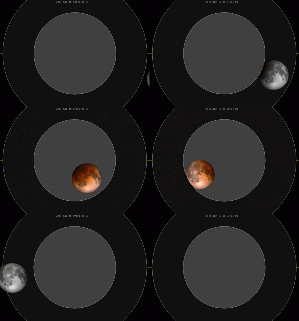
The night of Sunday 27th / Monday 28th September  promises a very special astronomical event for those fortunate enough to have clear skies overhead and are willing to stay up late (in the UK and Europe). It will see a total lunar eclipse take place at the time when the Moon reaches perigee, its closest approach to Earth in its orbit and giving rise to both a so-called “supermoon” and a “Blood Moon”.

A “supermoon” occurs when a full moon coincides with the time when the Moon is nearing its minimum distance to Earth, a distance of roughly 363,000 kilometres (226,875 miles), leading to it appearing 7-8% larger than when seen as a full Moon at other points in its orbit. A “blood moon” is the result of the Earth’s atmosphere, lying between the Sun and Moon, scatter blue light more strongly than red, so the latter reaches the Moon more strongly, giving it a reddish-brown colour when seen from Earth.

A total lunar eclipse occurs when the Sun, Earth and Moon are lined up so that th Earth is between the Sun and Moon, and the later sits within the Earth's shadow
A total lunar eclipse occurs when the Sun, Earth and Moon are lined up so that the Earth is between the Sun and Moon, and the latter sits within the Earth’s shadow (image: NASA)

Lunar eclipses are not that rare – this one will be the second of 2015, for example. However, “supermoons” are somewhat rarer. The last was in 1982, and the next will not be until 2033. So, if you want to see a really big blood moon, and you live in Western Europe, West Africa, the Eastern side of the USA and Canada or south America, then the 27th / 28th September is the night to do so. People further afield – eastern Asia, the middle east, eastern Europe and the western sides of Canada, the USA and South America will see a partial eclipse.

In the UK, the period of eclipse will start at around 01:00 BST (00:00 GMT) on the morning of Monday, 28th September, and run through until around 05:00 BST (04:00 GMT). That’s from 20:00 through to around 01:00 EDT in the USA / Canada, and 02:00 through 06:00 CET in Europe).

A total lunar eclipse and the gradual change in the Moon’s colour as seen from Earth which sees total lunar eclipses sometimes referred to as “blood moons” – the result of sunlight passing through the Earth’s atmosphere and striking the Moon’s surface (animation: Wikipedia)

The eclipse brings to a close what is referred to as a “tetrad” of total lunar eclipses – that is, four occurring “back-to-back”, with no partial eclipses between them, the first of which occurred in April 2014 and the “middle two” in October 2014 and April 2015. Some have a misguided view that this “tetrad” as being of particular significance because such events are “rare”, and this particular one started on the Passover.

However, while there can be long periods of time between occurrences of tetrads, they can also pop-up relatively frequently. For example, this century will see a total of nine tetrads occur, the first having taken place in 2003/4. Nor is the fact that this particular series started on the Passover particularly unusual; there have been eight tetrads so far coinciding with Passover since the first century AD.

So, if you are in a position to see the eclipse, you can leave the tinfoil hat on the table and step outside quite safely. Totality should occur around two hours after the eclipse starts (e.g. 03:00 BST in the UK / 04:00 CET, 22:00 EDT on the 27th September), and that’s the best time to enjoy the blood moon in all its glory.

The eclipse will also give NASA the chance to measure the full range of temperature variations during  such an event. This will be done by the Lunar Reconnaissance Orbiter (LRO), a solar-power vehicle which has been observing the Moon since 2009.

Normally during an eclipse, the LRO has most of its systems powered down to reduce the load placed on the battery systems. However, mission controllers are confident they will be able to run an instrument which will allow it to accurately measure the amount of heat loss the surface of the Moon experiences when inside the Earth’s shadow, further helping them to understand the composition of the Moon’s regolith and its function as an insulator.

Continue reading “Space Sunday: of blood moons, Mars, Pluto and Ceres”

Space Sunday: see Pluto’s mountains and the size of the Solar System

Back lit by the sun: Pluto's hazy atmosphere seen from just 18,000km (11,000 miles) and 15 minutes are the point of closest approach to the planet by the New Horizons spacecraft on July 14th, 2015. To the upper right of the planet can be seen the icy expanse of "Sputnik Planum", bordered below and to the left by tall mountains, and to the right by what appears to be glacial outflows. Image courtesy of NASA / JHU / APL,
Backlit by the Sun: Pluto’s hazy atmosphere seen from just 18,000km (11,000 miles) and 15 minutes are the point of closest approach to the planet by the New Horizons spacecraft on July 14th, 2015. To the upper right of the planet can be seen the icy expanse of “Sputnik Planum”, bordered below and to the left by tall mountains, and to the right by what appears to be glacial inflows. Image: NASA / JHUAPL / SwRI (click for full size)

Just when you thought images of Pluto returned by the New Horizons spacecraft could get any more awe-inspiring, NASA / JHU  APL release a set of raw images that are utterly stunning.

The images come from the wide-angle Ralph/Multispectral Visual Imaging Camera (MVIC) on the space craft and were captured just 15 minutes after the vehicle reached is point of closest approach to the little world, and thus from a distance of just 18,000 km (11,000 miles) from Pluto.

The stunning vistas presented in the image show the ice plains of “Sputnik Planum” bordered to the left and from below by Pluto’s huge mountain ranges, informally named Hillary and Norgay, Montes after the first partnership to successful reach the summit of Mt. Everest here on Earth. All of this is dramatically backlit by sunlight reflected through Pluto’s hazy atmosphere to create a wonderful scene said to be reminiscent of views of the Antarctic viewed from space or very high altitude.

A closer view: In this image just 380 km (230 miles) across, shows "Sputnik Planum" bordered to the west by towering mountains reaching up to 3,500 metres (11,000 ft) in altitude. In the foreground sit the informally-named Norgay Montes, and on the skyline to the top and left of the image, the Hilary Montes
A closer view: in this image just 380 km (230 miles) across, shows “Sputnik Planum” bordered to the west by towering mountains reaching up to 3,500 metres (11,000 ft) in altitude. In the foreground sit the informally named Norgay Montes, and on the skyline to the top and left of the image, the Hillary Montes. Image: NASA / JHUAPL / SwRI (click for full size)

However, the images aren’t just notable for the panoramic beauty; they actually reveal a lot about what is happening in the Plutoian atmosphere. Because of the back lighting from the Sun, the high-resolution MVIC has revealed just how complex Pluto’s atmosphere is, comprising multiple layers of nitrogen and other gases rising to around 100 km (60 mi) above Pluto’s surface (and visible as a banding in the images above).

“In addition to being visually stunning, these low-lying hazes hint at the weather changing from day-to-day on Pluto, just like it does here on Earth,” said Will Grundy, lead of the New Horizons Composition team from Lowell Observatory, Flagstaff, Arizona.

What is also exciting the science team is evidence within the images for Pluto having a complex “hydrological” cycle which seems to be comparable in some ways to that found on Earth – only on Pluto, it involves nitrogen ice, rather than water ice.

When compared with images captured as New Horizons approached Pluto, the MVIC images further suggest that the regions eastward of “Sputnik Planum” appear to have been encroached over time by ices and material possibly evaporated from the surface of “Sputnik Planum” to be deposited on the higher lands as a new ice blanket, which in turn appears to have formed glacial formations flowing back into “Sputnik Planum”.

Glacial flow on Pluto: deposits of frozen nitrogen which have accumulated on the uplands on the right side of this 630 km (390 mi) wide image has formed glacial flows leading from the uplands beck into "Sputnik Planum" draining from Pluto’s mountains onto the icy plain through the valley system indicated by the red arrows (the valleys average between 3 and 8 km (2 and 5 mi) in width). In the meantime, the ice of the plain appears to be flowing outwards and towards the uplands, as indicated by the blue arrows. Image: NASA/JHUAPL/SwRI.
Glacial flow on Pluto: deposits of frozen nitrogen which have accumulated on the uplands on the right side of this 630 km (390 mi) wide image has formed glacial flows leading from the uplands beck into “Sputnik Planum” draining from Pluto’s mountains onto the icy plain through the valley system indicated by the red arrows (the valleys average between 3 and 8 km (2 and 5 mi) in width). In the meantime, the ice of the plain appears to be flowing outwards and towards the uplands, as indicated by the blue arrows. Image: NASA / JHUAPL / SwRI (click for full size)

“We did not expect to find hints of a nitrogen-based glacial cycle on Pluto operating in the frigid conditions of the outer solar system,” said Alan Howard, a member of the mission’s Geology, Geophysics and Imaging team from the University of Virginia, Charlottesville. “Driven by dim sunlight, this would be directly comparable to the hydrological cycle that feeds ice caps on Earth, where water is evaporated from the oceans, falls as snow, and returns to the seas through glacial flow.”

To Scale: The Solar System

We’re all familiar with the idea that the solar system is so vast, that it is almost impossible to show the Sun and the major planets proportional to one another and at a scale where all the later are both visible and have orbits which can be adequately encompassed in an easily viewable space.

1972: The Blue Marble (click to enlarge)

Obviously, some models do exist; the Lowell Observatory in Arizona, USA, for example, has a walk that allows visitors to travel from the sun and by each of the planets, but it’s not always easy to clearly grasp the sheer scale of things. The same goes for digital models (and a few have been built within virtual worlds like Second Life).

With this issue of scale and proportion in mind, Wylie Overstreet and Alex Gorosh set out to produce a scale model of the solar system that might help people understand just how vast our planetary back yard is when looked at on a human scale.

They started with a blue marble to represent the Earth, echoing the famous photograph taken on December 7, 1972, by the crew of Apollo 17 en route to the Moon and which NASA dubbed the Blue Marble.

Continue reading “Space Sunday: see Pluto’s mountains and the size of the Solar System”

Space Sunday: of Pluto, Mars and crowdfunding space outreach

new-horizonNASA and the Applied Physics Laboratory (APL) at John Hopkins University kept their promise a little earlier than expected.

With the resumption of image and data transmissions from New Horizons, at the start of September, they had indicated that Fridays would henceforth, and for the course of the next 12 months, be known as Pluto Friday, the day on which the latest raw images from the mission to that distant tiny world and its companions would be released.

However, the first set of images came a little sooner than advertised: on Thursday, September 10th, and they continue to show two tiny worlds which continue to astound and have planetary scientists rethinking much about their understanding of dwarf planets.

“Pluto is showing us a diversity of landforms and complexity of process that rival anything we’ve seen in the solar system,” New Horizons’ principal investigator Alan Stern, from the Southwest Research Institute in Colorado, said in a statement. “If an artist had painted this Pluto before our flyby, I probably would have called it over the top — but that’s what is actually there.”

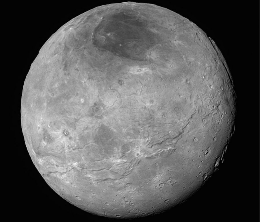
Charon, Pluto's largest companion, as seen by New Horizons on July 14th, 2015, from a distance of some 464,000 kilometres (290,000 miles), revealing a rich and diverse range of surface features
Charon, Pluto’s largest companion, as seen by New Horizons on July 14th, 2015, from a distance of some 464,000 kilometres (290,000 miles), revealing a rich and diverse range of surface features (image: NASA / JHU / APL / SWU) – click any image for the full-size version

The images render details as small as 400 metres / 440 yards per pixel on the surface of Pluto, and reveal features that have scientists agog with excitement; so much so that at a NASA press conference, the images were summarised thus, “it’s complicated!”

In them, we can see a rich complexity of features: nitrogen ice flows which have apparently oozed (and might still be slowly oozing) out of mountain ranges and across broad plains; mountain ranges which are themselves reminiscent of chaotic regions on Mars and Jupiter’s Europa; complex valley systems which might have been carved by the action of material flowing across the planet; and even – perhaps most curiously of all –  what seem to be wind-blown fields of dunes.

A synthetic perspective view of Pluto, based on the latest high-res received from New Horizons presents a view of Pluto from around 1,800 km (1,100 mi) above Pluto’s equatorial area. Towards the bottom of the image is the cratered and dark region dubbed "Cthulhu Regio", and above it, the bright "heart" of Pluto, showing the icy plains of "Sputnik Planum". The images used to create this view were captured from a distance of 80,000 km (50,000 mi) from Pluto
A synthetic perspective view of Pluto, based on the latest high-res received from New Horizons presents a view of Pluto from around 1,800 km (1,100 mi) above Pluto’s equatorial area. Towards the bottom of the image is the cratered and dark region dubbed “Cthulhu Regio”, and above it, the bright “heart” of Pluto, the “Tombaugh Regio”, with the icy plains of “Sputnik Planum” prominent. The images used to create this view were captured from a distance of 80,000 km (50,000 mi) from Pluto (images: NASA / JHU / APL / SWU) – click any image for the full-size version

What is also particularly striking about these images of Pluto is the way that they reveal some of the oldest  (geologically speaking) regions yet seen on the planet sitting right alongside what are the youngest locations on the planet, adding further emphasis to the idea that Pluto has been, and might still be, an active world.

But what about those dunes mentioned above? If they are indeed what the images released on September 10th suggest, Pluto has once again served up a surprise.

“Seeing dunes on Pluto, if that is what they are would be completely wild!” William McKinnon from the mission’s Geology, Geophysics and Imaging (GGI) team, said, “because Pluto’s atmosphere today is so thin. So either Pluto had a thicker atmosphere in the past, or some process we haven’t figured out is at work. It’s a head-scratcher!”

The dunes of Pluto? This image, representing a portion of Pluto's surface some 350 km (220 mi) across, shows some of the planet's older, chaotic terrain at the bottom, and an enigmatic field of dark, aligned ridges that resemble dunes which have caused planetary scientists to feel their eyebrows further vanishing under hair lines. The image was captured from a distance of 80,000 km (50,000 mi) from Pluto.
The dunes of Pluto? This image, representing a portion of Pluto’s surface some 350 km (220 mi) across, shows some of the planet’s older, chaotic terrain at the bottom, and an enigmatic field of dark, aligned ridges that resemble dunes toward the top. The image was captured from a distance of 80,000 km (50,000 mi) from Pluto (images: NASA / JHU / APL / SWU)

More is also being discovered about Pluto’s atmosphere, which is also proving to be a lot more complex than had originally been thought, having many more layers within its thin haze than had been thought. However, these layers of haze have allowed the science team to glimpse surface features which might otherwise have remained unseen as sunlight caught by the haze over the terminator – the divide between the day and night sides of the planet – cast a soft glow over part of Pluto’s night side. When enhanced through careful processing, this glow could be used to reveal what lay below.

Continue reading “Space Sunday: of Pluto, Mars and crowdfunding space outreach”

Space Sunday: Pluto calls, Mars mystifies, Starliner prepares

new-horizonIt’s been a little quiet on the new images front where the New Horizons mission is concerned. The spacecraft, which performed the first ever flyby of Pluto and Charon in July, gathered a wealth of data, around 95% of which has remained aboard the spacecraft awaiting transmission back to Earth.

There have been a number of reasons this has been the case. First off, for the period following the close encounter, New Horizons continued to gather data and images of the Pluto-Charon system. Such is the design of the vehicle that while doing this, it couldn’t actually transmit information back to Earth. Also, once the data had been gathered it required sorting and prioritising ready for transmission back to Earth, and this again took time to do.

However, on Saturday, September 5th, New Horizons oriented itself to make contact with the Deep Space Network (DSN) operated by NASA for what was the start of a year-long “intensive” download of the 10 gigabits of data gathered by the craft, starting with information the science team regard as the highest priority data sets.

The reason the transfer will take so long is not only because the enormous distance between New Horizons and Earth, which takes radio signals moving at the speed of light over 4.5 hours to cross (a time which is slowly increasing), but also because the rate at which the data can be transmitted is limited.

Currently, the nuclear “battery” powering New Horizons can only produce around 2-10 watts of electrical power, which has to keep all of the various electrical systems warm and running. So to conserve power, the vehicle only transmits data at between 2-4 kbps. To put that in perspective, it would take you about 2 hours to download a single photo from your cellphone to your computer at those speeds.

NASA Deep Space Network facility near Canberra, Australia
NASA Deep Space Network (DSN)  is a set of three communications facilities operated by NASA in Spain, Australia (shown above) and California. They are tasked with maintaining communications with NASA’s deep space and planetary missions. Located roughly 120-degrees apart around the Earth, the three facilities can between them maintain a constant radio observation on any spacecraft under their command as the Earth rotates.

Discussing the start of the extended data download from New Horizons, Alan Stern, the mission’s Principal Investigator, said, “this is what we came for – these images, spectra and other data types that are going to help us understand the origin and the evolution of the Pluto system for the first time.”

He continued, “and what’s coming is not just the remaining 95 percent of the data that’s still aboard the spacecraft – it’s the best datasets, the highest-resolution images and spectra, the most important atmospheric datasets, and more. It’s a treasure trove.”

To mark the receipt of data and images, NASA / JPL and John Hopkins’ APL have designated Friday as Pluto Friday, when they’ll be publishing that latest images, unprocessed, received from the spacecraft the previous week. The images will be available on the LORRI image catalogue, operated by JHU / APL, starting on Friday, September 11th, 2015.

In the meantime, here’s an animated video from NASA, showing the Pluto flyby, just to whet appetites.

Mars’ Atmosphere: Where did It Go?

One of the many mysteries of Mars is what happened to its atmosphere. All of the evidence gathered over the years about the Red Planet is that it once had an atmosphere dense enough to support free-flowing liquid water, and that potentially as much of 20% of the planet’s surface may have been submerged.

So what happened? There are a number of theories. One of these is that over time, the action of the solar wind, combined with Mars’ relatively weak gravity, effectively “scooped” much of the atmosphere away into space.   Measurements of heavy and light carbon ratios in the present day atmosphere lend considerable weight to this theory.

An artist's impression of what a wet Mars may have looked like, based on the ratio of deuterium contained within the Martian polar caps
An artist’s impression of what a wet Mars may have looked like, based on the ratio of deuterium contained within the Martian polar caps

Another idea is that carbon dioxide, the major constituent of Mars’ atmosphere may have been “sequestered” – that is, “pulled” out of the atmosphere to be stored in rocks and subsurface deposits by various chemical reactions, forming carbonate minerals in the process.

This theory was given its own boost when a region of Mars called Nili Fossae, approximately as big as the US state of Arizona, was found to have huge deposits of carbonates (more recently this region has been of interest to scientists due to the discovery of impact glass, helping to mark the region as a candidate target for the Mars 2020 rover mission).

Continue reading “Space Sunday: Pluto calls, Mars mystifies, Starliner prepares”

Sinewave.space: a further contender for virtual spaces

The above video has been gaining attention since first appearing on You Tube at the end of August. It’s advance promotion for a new virtual worlds platform called Sinewave.space, built using the Unity 3D engine, and which may be opening its doors to initial users in December 2015.

The company behind Sinewave.space is Sine Wave Entertainment, a name which may be familiar to many Second Life users, given it is also the company behind the highly successful Sine Wave animations brand in-world.

Spearheading the work is Sine Wave’s CEO, Adam Frisby, a man who has considerable experience with virtual world platforms, having been one of the founders of the OpenSimulator project. In Second Life he is probably better known as Adam Zaius, the man behind such ventures as Azure Islands and the DeepThink virtual worlds development agency, which operated in both Second Life and OpenSim.

Adam Frisby is perhaps more recognisable to many in SL as Adam Zaius

Nor are Sine Wave Entertainment new to the virtual worlds market. They’ve built and operated a number of virtual world spaces themselves, and they’ve produced virtual world spaces on behalf of clients, with all of their products created using the Unity 3D engine.

Perhaps the largest of their own environments is Wet.fm, a music-focused virtual environment claiming some 400,000 “live audience members”, 120 artists and some 600 music events held to date.

Chief among client-oriented spaces the company have developed is Flybar, a “multiplayer social game and on-line cinema for [the] globally distributed Spanish language soap opera Cuéntame cómo pasó“, and  which claims 1.2 million unique visitors since  2012, together with the Gojiyo virtual world / platform The latter was originally developed for India’s Godrej Industries and boasts 1.7 million registered users. It also appears to have what might be called associated games or spin-offs, such as Jiyopets.

Sine Wave are responsible for the India-based virtual world, GoJiyo, for Godrei Industries, and which boasted 1.7 million registered users

Reading the available information about sinewave.space, it’s interesting to note the similarities in approach between it and Project Sansar. For example, both platforms are intended to be white label environments in which creators can build their own branded spaces, and then promote  / market them directly to their potential audience, complete with sign-up portal, etc., without that audience necessarily being aware that the space they are entering is part of a platform providing many such spaces / experiences.

Further, both companies indicate the spaces within each platform could potentially be of unlimited size (Sine Wave indicate bandwidth, and Linden Lab the physics simulator, as being the only practical limitations to “land size”);  both platforms will offer a mix of “in-built” tools as well as support for a broad range of 3rd party tools for content creation – although Sine Wave would appear to be significantly further down the road in this. Sine Wave and Linden Lab also appear to be steering a similar course in terms of offering central user account management, virtual goods marketing, etc., which can be used across multiple environments running on their platforms.

Among their tool chain - which includes an advanced animation / gesture system - is the "humanoid resizer", intended to allow mesh clothing sized for "poular avatar skeletons" to be automatically resized to fit the primary Sinewave.space avatar skeleton
Sine Wave are offering a content creation tool chain which includes an advanced animation / gesture system and, as illustrated above, a “humanoid resizer” tool, designed to allow mesh clothing sized for “popular avatar skeletons” to be automatically resized to fit the primary Sinewave.space avatar skeleton

Which should not be taken to mean I think the two are in any way connected – I don’t. Rather, I find it interesting that two companies, each with their own approach to building and running immersive 3D spaces, have arrived at a similar conceptual approach as to how to build a platform aimed at being flexible enough in design and implementation to appeal to a wide cross-section of potential use-cases, without necessarily tying creators / clients / partners – or indeed, users – to a single branded environment.

Obviously, there are differences as well. For example, Sine Wave have indicated that among the worlds running on Sinewave.space will be a number of their own spaces – such as the aforementioned wet.fm, which is due for a re-launch under the sinewave.space banner in the near future – with the Sine Wave portfolio listing a number (all?) of such spaces which might be candidates for inclusion.

Sine Wave also produce Convvirt, a business-oriented space built on Unity 3D. Whether it is to form a part of the overall sinewave.space "federation" of virtual worlds is unclear, but it is listed as a part of the also listed under the Sinewave.space portfolio, so one assumes so
Sine Wave also produce Convvirt, a business-oriented space built on Unity 3D. Whether it is to form a part of the overall Sinewave.space “federation” of virtual worlds is unclear, but it is listed as a part of the also listed under the Sine Wave portfolio bearing the Sinewave.space brand, so one assumes so

Sine Wave also have the advantage of building on an engine – Unity 3D – with which they have many years of experience of both operating and using to build virtual spaces, rather than starting entirely from scratch. Lessons learned from past efforts can be put directly to use. They are also well-versed in the tools an capabilities contained within the engine without having to go through an internal learning curve as a part of the development process, and they have experience in combining the tools within the engine with their own tools – motion capture, animation, etc. – to present creators with an integrated tool chain.

As it is, and as noted earlier, Sine Wave are seeking content creators – region designers, clothing designers, animators and gesture designers, vehicle builders, and more – and in doing so, they’re offering those signing-up a 70/30 (in the creator’s favour) revenue split on all content sold within the platform’s worlds when they are opened to users. Those interested should follow the above link to find out more.

It’ll be interesting to see how sinewave.space develops over the coming months, both independently as with Project Sansar as a possible frame of reference (and even vice-versa), and I hope to be able to provide updates on progress through these pages.

Note; this article was largely drafted prior to show #84 of the Drax Files Radio Hour podcast, in which Drax talks to Adam Frisby about Sinewave.space. You can hear the conversation starting at the 34:30 mark, with an introduction by Drax.

Space Sunday: of selfies, sprites, and black holes

CuriosityCuriosity, NASA’s Mars Science Laboratory rover has departed “Marias Pass”, a geological contact zone between different rock types on the slopes of “Mount Sharp”, some of which yielded unexpectedly high silica and hydrogen content.

As noted in a recent space update in these pages, silica  is primarily of interest to scientists, because high levels of it within rocks could indicate ideal conditions for preserving ancient organic material, if present. However, as also previously noted, it may also indicate that Mars may have had a continental crust similar to that found on Earth, potentially signifying the geological history of the two worlds was closer than previously understood. Hydrogen is of interest to scientists as it indicates water bound to minerals in the ground, further pointing to Gale Crater having once been flooded, and “Mount Sharp” itself the result of ancient water-borne sediments being laid down over repeated wet periods in the planet’s ancient past.

Curiosity actually departed “Marias Pass” on August 12th, after spending a number of weeks examining the area, including a successful drilling and sample-gathering operation at a rock dubbed “Buckskin”, where the rover also paused to take a “selfie”, which NASA released on August 19th. It is now continuing its steady climb up the slopes of “Mount Sharp.”

A low-angle self-portrait produced from multiple images captured by the Mars Hand Lens Imager (MAHLI) camera mounted on the "turret" at the end of the rover's robot arm. The images were taken on August 5th, as the rover was parked at the "Buckskin" rock formation from which it gathered drill samples
A low-angle self-portrait produced from multiple images captured by the Mars Hand Lens Imager (MAHLI) camera mounted on the “turret” at the end of the rover’s robot arm. The images were taken on August 5th, as the rover was parked at the “Buckskin” rock formation from which it gathered drill samples

As it does so, initial analysis of the first of the samples gathered from “Buckskin” is under-way. It is hoped with will help explain why the “Marias Pass” area seems to have far higher deposits of hydrogen bound in its rocks than have previously been recorded during the rover’s travels. This data has been supplied by the Dynamic Albedo of Neutrons (DAN) instrument on Curiosity, which almost continuously scans the ground over which the rover is passing to gain a chemical signature of what lies beneath it.

“The ground about 1 metre beneath the rover in this area holds three or four times as much water as the ground anywhere else Curiosity has driven during its three years on Mars,” said DAN Principal Investigator Igor Mitrofanov of Space Research Institute, Moscow, when discussing the “Marias Pass” DAN findings. Quite why this should be isn’t fully understood – hence the interest in what the drill samples undergoing analysis might reveal.

A stunning vista: the slopes of "Mount Sharp" as seen by Curiosity as it commenced the upward drive away from "Marias Pass". Captured by the rover's Mastcam systems, the image shows an intriguing landscape, with the gravel and sand ripples typical of much of the terrain over which the rover has passed in the foreground. In the middle distance sit outcrops of smooth, dust-covered bedrock, above which sit sandstone ridges. On the horizon sit rounded buttes, rich in sulfate minerals, suggesting a change in the availability of water when they formed - click image for the full size version
A stunning vista: the slopes of “Mount Sharp” as seen by Curiosity as it commenced the upward drive away from “Marias Pass”. Captured by the rover’s Mastcam systems, the image shows an intriguing landscape, with the gravel and sand ripples typical of much of the terrain over which the rover has passed in the foreground. In the middle distance sit outcrops of smooth, dust-covered bedrock, above which sit sandstone ridges. On the horizon sit rounded buttes, rich in sulfate minerals, suggesting a change in the availability of water when they formed – click image for the full size version

The drilling operation itself marked the first time use of the system since a series of transient short circuits occurred in the hammer / vibration mechanism in February 2015. While no clear-cut cause for the shorts was identified, new fault protection routines were uploaded to the rover in the hope that should similar shorts occur in the future, they will not threaten any of Curiosity’s systems.

A Flight over Mars

With all the attention Curiosity gets, it is sometimes easy to forget there are other vehicles in operation on and around Mars which are also returning incredible images and amounts of data as well – and were doing so long before Curiosity arrived.

One of these is Europe’s Mars Express, the capabilities of which come close to matching those of NASA’s Mars Reconnaissance Orbiter. Mars Express has been in operation around Mars for over a decade, and in that time has collected an incredible amount of data.

At the start of August, ESA released a video made of high resolution images captured by the orbiter of the Atlantis Choas region of Mars. This is an area about 170 kilometres long and 145 wide (roughly 106 x 91 miles) comprising multiple terrain types and impact craters, thought to be the eroded remnants of a once continuous ancient plateau. While the vertical elevations and depressions have been exaggerated (a process which helps scientists to better understand surface features when imaged at different angles from orbit), the video does much to reveal the “magnificent desolation” that is the beauty of Mars.

Continue reading “Space Sunday: of selfies, sprites, and black holes”