It’s been fairly quiet as the Mars Science Laboratory (MSL) rover Curiosity continues driving towards the point at which it is hoped the rover can traverse between a line of low-lying sand dunes and start exploring the lower slopes of Aeolis Mons, which NASA has dubbed “Mount Sharp”.
However, Thursday November 7th saw an unexpected hiccup in proceedings as Curiosity unexpectedly performed a “warm reset” (software reboot). This occurred around four and a half hours after the new flight software uploaded to the rover (see my last mission report) had been temporarily loaded into memory as a part of the uploading and commissioning of the software, and while the rover was also transmitting data to the Mars Reconnaissance Orbiter (MRO) for later transmission to Earth.
A warm reset is executed when the flight software identifies a problem with one of the operations it is executing which may adversely affect the rover’s operations, and is a standard fault protection mode on all automated craft operated by NASA. It resets the software to its initial state, preventing further issues occurring. While there have previously been problems with Curiosity’s on-board computers, this was actually the first time since the rover’s arrival on Mars 16 months ago that a fault-related software warm reset had been executed.
Curiosity, seen here in an artist’s impression working on Mars, suffered its first software reset on November 7th
Following the reset, the rover resumed communications, but the mission team initiated a root cause analysis for the reset using the ground testbed unit (essentially, Curiosity’s Earthside “twin”). This revealed an error in a catalogue file for the existing onboard software was triggered when the catalogue file was executed by the newly uploaded flight software, causing the reset. As a result of this analysis, the flight software team were able to determine the steps required to recover the rover to its operating state prior to the reboot. These were successfully uploaded to Curiosity, and on Sunday November 10th, the rover set confirmation to mission controllers that it has successfully transitioned back to a nominal surface operations mode.
“We returned to normal engineering operations,” software and systems engineer Rajeev Joshi from the Curiosity team at JPL reported following the transition. “We are well into planning the next several days of surface operations and expect to resume our drive to Mount Sharp this week.”
Following the successful reinstatement of normal operations for the rover, the mission science team resumed planning for the next stage of Curiosity’s surface activities, which were due to restart on Thursday November 14th.
No, this isn’t a return to coverage of Wars of the Worlds in SL. November marks the start of the next round of missions to Mars, with two new orbiters about to depart Earth as a part of our efforts to better understand the Red Planet and its atmosphere. Meanwhile, and despite a lack of headline news, NASA’s Mars Science Laboratory (MSL) continues its own explorations of the Red Planet, as does its little cousin Opportunity, half a world away.
Driving Forward
During the last week of October, the MSL rover Curiosity chalked up another achievement making its first pair of back-to-back autonomous drives using its on-board capabilities rather than relying on assistance from Earth.
I’ve covered the benefits of Curiosity’s ability to “self navigate” and how it works in previous MSL reports. However, up until now the system has only been used after the rover has initially traversed a course carefully plotted by the drive team on Earth using images taken by the rover and from overhead passes of the Mars Reconnaissance Orbiter (MRO).
This was the case with the rover’s drive on Sunday 27th October, when it completed an autonomous drive after a plotted drive. However, on Monday 28th October Curiosity immediately resumed its autonomous drive without any input from Earth, heading for the next waypoint along the route which will eventually bring it into the lower slopes of “Mount Sharp”.
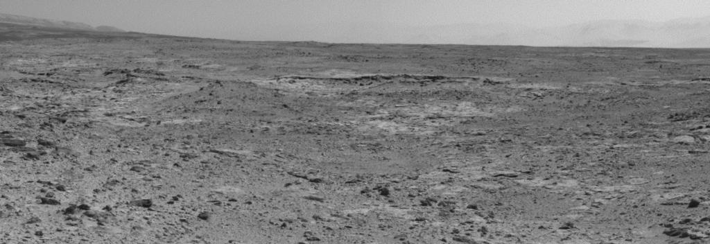
Next stop “Cooperstown”, the raised outcrop in the centre of this image from Curiosity’s Navcams, captured at the end of the rover’s back-to-back autonomous drives on October 28th, 2013 (Sol 437).
This waypoint, dubbed “Cooperstown”, is a rocky outcrop which had been identified as a candidate for examination by the rover in MRO images of the route to “Mount Sharp”. It is anticipated that Curiosity will spend no more than a day examining the outcrop, which is liable to be done predominantly using the instruments mounted on the turret at the end of the rover’s robot arm.
“What interests us about this site is an intriguing outcrop of layered material visible in the orbital images,” said Kevin Lewis of Princeton University and a participating scientist for the mission responsible for planning the “Cooperstown” activities. “We want to see how the local layered outcrop at ‘Cooperstown’ may help us relate the geology of ‘Yellowknife Bay’ to the geology of ‘Mount Sharp’.”
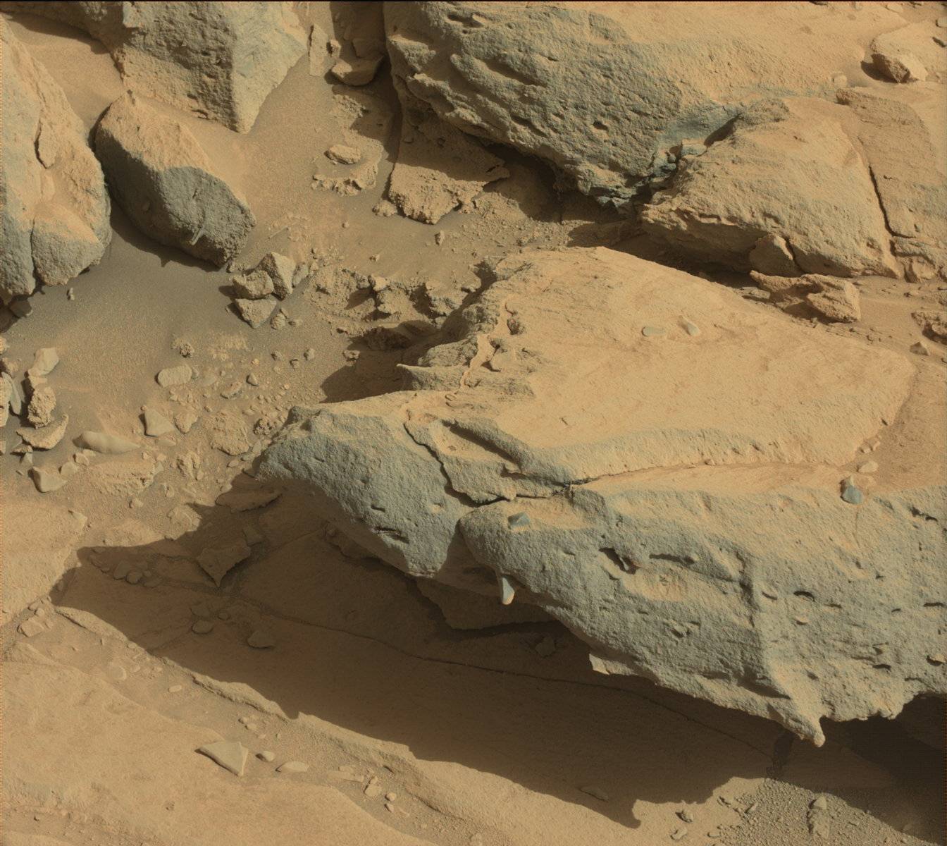
A high-resolution raw image of part of the “Cooperstown” outcrop captured using Curiosity’s Mastcam on Sol 440 (November 1st, 2013)
“Yellowknife Bay” is an area of Gale Crater which, alongside that of “Glenelg”, the rover spent some 6-months examining various rock formations and gathering samples for analysis.
The planned duration of the “Cooperstown” stop is in marked contrast to the rover’s last waypoint stop, and coupled with the testing of back-to-back autonomous drives, is aimed at accelerating Curiosity’s progress towards the desired destination of “Mount Sharp”. So far, the rover has traversed around one-third of the 8.6 kilometres (5.3 miles) separating the “Yellowknife Bay” area, which it left in July 2013, from the entry point to the lower slopes of “Mount Sharp”.
The ability for the rover to safely store data necessary for it to resume self-navigation in its onboard memory is also vital for future planning for Curiosity’s progress over the upcoming holidays, when it is hoped that multi-day operations for the rover can be planned and uploaded, allowing the rover to continue in a range of activities, including driving, rather than necessarily spending the entire holiday periods parked-up and performing static science.
The next key activity for the rover is the uploading of the third new version of the on-board software. Such uploads are periodically needed in order to both prepare the rover for upcoming aspects of the mission and to improve its capabilities. This next update will see improvements in the information the rover is able to store overnight for the purposes of autonomous driving, updates to the software controlling the robot arm which should further increase the ability to use the arm when the rover is parked on a slope – something which is likely to be needed once Curiosity starts exploring “Mount Sharp”.
Back in May 2013, and courtesy of The Verge, I was able to report on the development of castAR, an Augmented Reality headset, a prototype of which made an appearance at the May 2013 Maker Faire in New York.
The project, initially started by Jeri Ellsworth and colleague Rick Johnson while both were employed by Valve, came about by accident. However, development work in-house at Valve came to an end in February 2013 when both Ellsworth and Johnson were let go by the company. But in a generous move, Gabe Newell, co-founder and Managing Director of Valve, gave them his blessings to take the idea and the associated IP with them.
The castAR glasses
As I reported back in May, convinced the idea had legs, Ellsworth and Johnson founded their own company, Technical Illusions, and have been hard at work developing things further.
The castAR system differs from the likes of Oculus Rift in that in its primary function is augmented reality, rather than immersive virtual reality. It projects images onto a retroreflective projector screen. A camera also built-in to the glasses tracks the exact position of your head so that the software can adjust the 3D perspective in real-time. The result is a holographic-like projection of images and objects from the computer as 3D objects which you can move around and examine.
At the time of the May 2013 Maker Faire, the team had managed to put together a very rough-and-ready prototype of the system, and have since been working to further refine the technology and the idea. In September, they were back in New York for another Maker Faire, where they were awarded blue and red ribbons with a win of Editors and Educators Choice. Buoyed by this, the team set-out to move ahead with their planned Kickstarter project in order to secure funding which would allow the work to continue and would hopefully see the system further refined, including the creation of a software development kit which might in turn help with adoption of the system.
The Kickstarter launched on October 14th, 2103 together with a video expanding on the idea and their plans. They’d hoped to raise $400,000 in a one-month period to November 14th, 2013.
As of October 18th, over $500,000 had been pledged by more than 2,000 people.
The castAR wand
Interaction with the virtual projections can be achieved through both the use of traditional games controllers and joysticks, or via a dedicated “magic wand”. The latter allows for a wide range of interactions, with Sean Hollister of The Verge using it to play a virtual game of Jenga. Other elements, such as an RFID grid and “bases” which can be attached to physical objects allows such objects to be used within the virtual projection, with movement of such objects interactively plotted, etc.
As with Oculus Rift, uses for the system are potentially huge. Not only could castAR be used for computer games and virtual worlds, it might equally be used for playing board games (with players sitting anywhere in the world), or for it to be used in diverse fields as research, data visualisation work, 3D design, virtual worlds and so on.
For those wishing to experience more of an immersive, Occulus-like virtual reality experience, such as when using castAR in a virtual environment like Second Life, Technical Illusions are developing what they call the “AR & VR Clip on”. This allows users to dispense with the retroreflective surfaces and experience images projected onto a pair of screens, the result matching that of the Oculus Rift.
It’s been a while since I last reported on developments over on Cloud Party. There’s a lot that has been going on and which I’ve received e-mails about; I’ve just not had time to sit down and write-up everything.
The platform has recently started introducing features and capabilities on a weekly basis which have seen one or two new features introduced each week. The most recent of these is an official announcement of support for Oculus Rift.
Cloud Party’s CTO Conor Dickinson using Oculus Rift (courtesy of Cloud Party)
The blog post, issued on Wednesday October 9th, gave details on the support being provided, including the regions within Cloud Party which have been set-up for use with the headset.
There’s currently no native Rift support within Cloud Party, so those with an Oculus Rift SDK kit will need to go one of two routes: either run OculusBridge, a standalone app which bridges the headset and a web browser via websockets, or via vr.js, a browser plugin which works directly with the headset (although the blog post notes this is not recommended as a result of Google’s announcement that Chrome will cease support for plugins in 2014).
The blog post additionally provides general advice on using the Rift – including notes about head movement (the visual stimulus and sudden head movements have been known to cause nausea and other issues as a result mismatched inner-ear cues).
One of the builds within Cloud Party supporting Rift use is a hoverbike race, which appears to be based on the race launched in late September and promoted via a short video.
Other recent updates over the past two months or so have seen a revamp of the Cloud Party website, which had it take on far more of a social environment feel, with the ability to preview people’s builds, “Like” them, share them via social media, etc., and which included the ability to embed builds in things like YouTube, etc.
August also saw the introduction of a new membership structure, with free accounts replaced the limited-functionality “anonymous” accounts together with a two-tier subscription option for general users. Thes free account option provides users with an unlimited number of “small” builds (up to 10MB bandwidth per build), 5 marketplace listings and knowledge base access.
The Basic subscription option, at $14.95 a month ($11.95 if paid annually), includes the “free” membership features and:
2 medium sized builds
20 free marketplace listings
Billing / Fraud Support
Privacy / group edit settings on builds
The Pro subscription, at $99.95 a month ($79.95 if paid annually) features the above and:
4 medium sized Builds, 2 large Builds
100 free marketplace listings
Live tech support
There is also an Enterprise subscription / billing option, but details of this have to be applied for from Cloud Party directly.
Further recent updates have seen avatars within Cloud Party become more customisable, with facial customisations and animated attachments, while builds have gained customisable skies and the ability to play videos.
A key factor with many of the updates is that they’ve also been accompanied with tutorials on how to make use of them’ such as with the customisable skies, helping users make the most of the updates. One has been promised for the Oculus Rift support as well.
For those not already aware of the fact, Cloud Party is no longer tied to Facebook for access. You can now do so via Facebook or Google+ or via account registration. As a formally “anonymous” user, I switched to using my Google+ account back in August. Logging-in with it was smooth and hassle-free – although I did experience an odd moment of deja-vu when an avatar picker looking remarkably like the one used in Second Life many moons ago popped-up!
The avatar picker in Cloud Party. Reminiscent of the “old” SL avatar picker
All told, Cloud Party continues to hum along, and while it may not be to everyone’s taste, it’ll be interesting to see what else pops up in the coming weeks.
There has been a lot in the blogsphere over the last twelve months about virtual world and matters of health.
For example, there’s Fran Seranade (Fran Swenson in SL) and the benefits she’s personally experienced in using Second Life as a sufferer of Parkinson’s disease which has led to Donna Davis of the University of Oregon and Tom Boellstorff, an anthropology professor at UC Irvine researching the matter in-world. Virtual Ability has a long history of helping people with disabilities make full use of SL for the betterment of their real lives, and the Centre for ME/CFS and Other Invisible Illnesses is based in Second Life. There have also been numerous projects involving medical workers, such as the research performed by a team at the Imperial College London to improve patient management skills among surgical residents at hospitals.
Now over on InWorldz, the team there have taken things a step further – literally and figuratively – with an app which allows you to exercise at home while still exploring InWorldz.
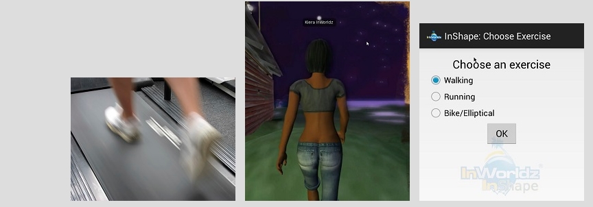
InWorldz InShape is currently available for Android devices, although iOS / Windows versions are promised for the future. It essentially gathers data on your real-world exercising when using a treadmill, stationary exercise bike or elliptical bike / trainer, and translates it to in-world movement. Thus, people using it can explore in-world regions with their avatar which exercising, and even compete against one another.
InWorldz InShape: spend time in-world while exercising at home
The app and idea are still very much beta, but already InWorldz residents have built a park where those with the app can go for walks / runs / rides, and there are plans to start weekly exercise sessions, allowing users to meet in-world and go through a routine together on a “group treadmill” while also exercising at home. The InWorldz team also hope that residents will build race tracks, walks and so on to make use of the app and offer further opportunities for combining fitness training with in-world activities with friends, making it easy to keep fit together.
InWorldz InShape in action: a walk in the park in-world (left) while exercising at home (r)
An InWorldz beta programme for the app has been launched, and the InWorldz team are looking for people to join them in trying it out. Those wishing to sign-up will need to have an InWorldz account and meet the following requirements:
Be in good enough physical health to start or participate in a light exercise programme (consulte your doctor if you have any concerns)
have enough time to participate in testing once a week, during the weekend, for about 45 minutes
own or have access to an android powered phone (Android 2.3.3 or later)
own or have access to: An exercise bike, elliptical, or treadmill and a computer or tablet that can run a viewer (/Lumiya) connected to the InWorldz Grid.
Those meeting these criteria can register their interest at the InWorldz website.
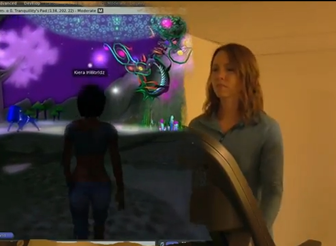
A demo video has been produced, hosted by InWorldz’s own Tranquility Dexler, which provides an in-depth look at the app in use.
This looks like a very practical and fun application for a virtual world environment, and could potentially see a lot of new opportunities for competitive undertakings in-world or bring a whole new dimension to something like the RFL track walks for people – again, providing due care is taken with RL fitness condition.
I’m keen to sign-up myself, but I don’t have the requisite exercise equipment. I wonder if they’ll ever be able to include a rowing machine and a lake to paddle across …?
Curiosity has resumed its long drive towards the point where it can begin its examination of the huge mound sitting at the centre of Gale Crater which NASA has dubbed “Mount Sharp” (its official name is Aeolis Mons).
The rover recently stopped-off at an area dubbed “Waypoint 1”, the first of several potential stop-over points on the rover’s route, where it will carried out various studies of the surroundings.
Curiosity departed the area on September 22nd after spending some 10 days examining rocks at “Waypoint 1”, and is once more travelling slowly but steadily towards the point mission managers have identified for it to bypass a dune field lying between it and “Mount Sharp”. Along the way, it is liable to make around four more stops.
While at “Waypoint 1”, the rover spent time examining a rocky outcrop dubbed “Darwin”, using a range of instruments to gather images and data which again showed that Gale Crater was once the scene of considerable water activity.
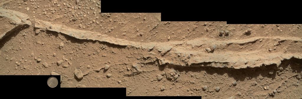
A mosaic of four images taken by the Mars Hand Lens Imager (MAHLI) camera shows detailed texture in a ridge on the rock outcrop dubbed “Darwin” the rover studied at “Waypoint 1”. The images were obtained shortly before sunset Sol 400 (Sept. 21, 2013) with the camera 25 cm (10 inches) from the rock. Scale is indicated by the Lincoln penny from the MAHLI calibration target, shown beside the mosaic.
“We examined pebbly sandstone deposited by water flowing over the surface, and veins or fractures in the rock,” said Dawn Sumner of University of California, Davis, a Curiosity science team member with a leadership role in planning the stop. “We know the veins are younger than the sandstone because they cut through it, but they appear to be filled with grains like the sandstone.”
While much of the outcrop was covered in the all-too-familiar oxidised Martian dust, there were a patches of bare rock scattered across its surface in which sand deposits and pebbles could be seen, and it was these that drew the attention of the science team.
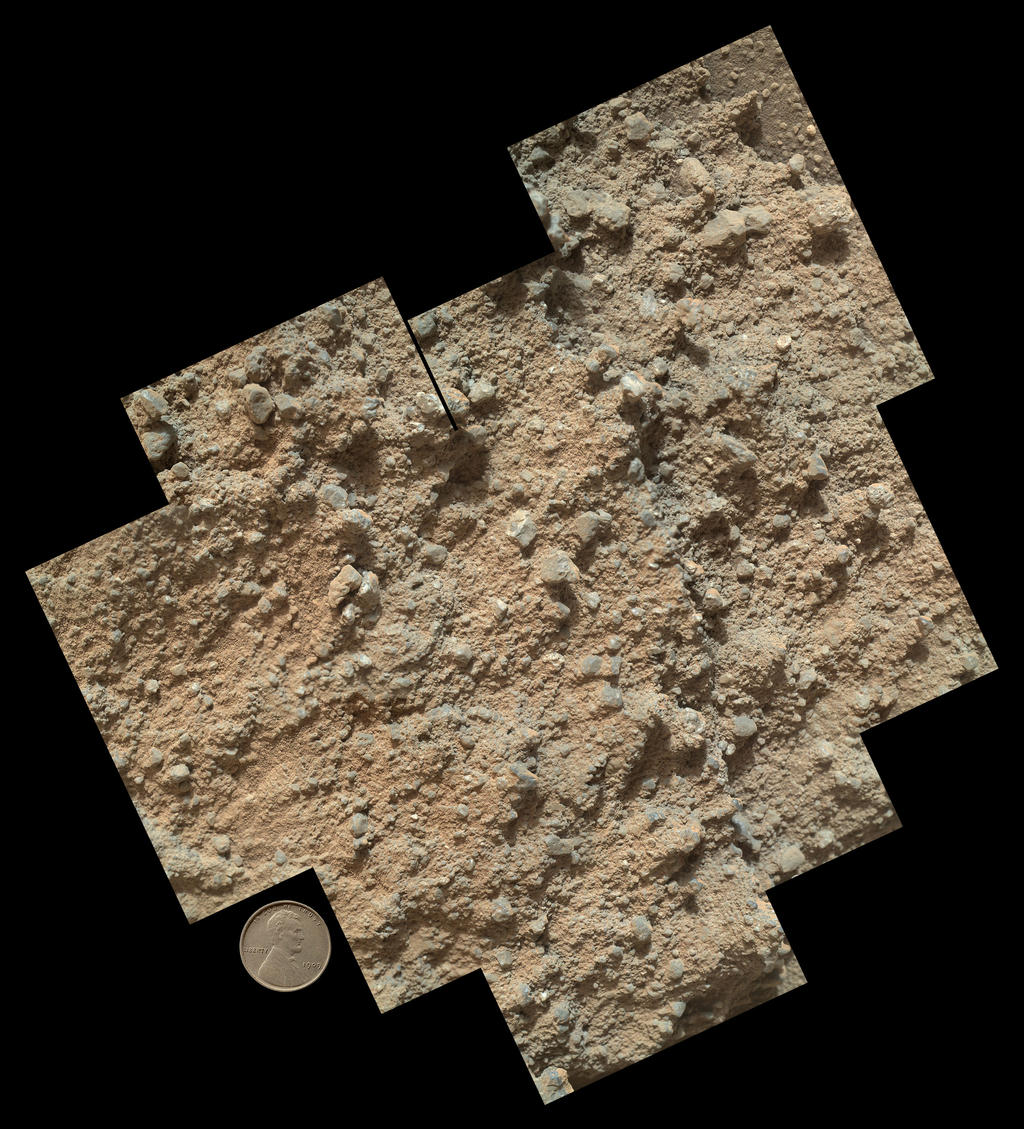
A mosaic of nine images, taken by the MAHLI camera, shows detailed texture in a conglomerate rock bearing small pebbles and sand-size particles. Again, these images were captured on Sol 400 (Sept. 21, 2013) with the camera positioned about 10 cm (4 inches) from the rock. Scale is indicated by the Lincoln penny from the MAHLI calibration target, shown beside the mosaic.
Following extensive studies of the outcrop, the science team interpret the sand and pebbles in the rock as material that was deposited by flowing water, then later buried and cemented into rock, forming conglomerates. Research will now focus on the textures and composition of the conglomerates as Curiosity continues onward, to understand its relationship to stream bed conglomerate rock found closer to Curiosity’s landing site. Doing so, together with studies to be undertaken at the remaining waypoints, should help scientists to piece together the relationship between rock layers at “Yellowknife Bay” where the mission found evidence of an ancient freshwater-lake environment favourable for microbial life, and the rock layers at the main destination on lower slopes of “Mount Sharp”.
Water, Water, Everywhere
On September 27th, the Curiosity team published five reports in the journal Science which discuss the mission’s findings during the first four months of the rover’s time on Mars. A key finding from this work is that water molecules are bound to fine-grained soil particles, accounting for about 2 percent of the particles’ weight at Gale Crater. This result has global implications, because these materials are likely distributed around the Red Planet.
The presence of water was discovered as a result of samples of surface material being heated to the point of vapourisation within a small oven inside Curiosity – and the most abundant vapour detected was H2O. The quantity of water molecules bound-up in the Martian soil suggest that as much as two pints of water could be obtained through the heating of one cubic foot of Martian dirt.
This discovery potentially has major implications for any long-term human presence on Mars in the future. The water – once subjected to appropriate treatment to remove unwanted minerals, such as a perchlorate, which has also been found in small amounts within Martian soil samples and can interfere with the thyroid function – could be used for cleaning and drinking purposes. It could also be electrolysed and used in the creation of oxygen and hydrogen. The hydrogen could then be used for a variety of purposes, including as a raw fuel, or in the production of fuel in the form of methane (created by combining the hydrogen with carbon dioxide from the Martian atmosphere), which could be used with oxygen to power surface vehicles.
An interesting part of the study is that the analysis of the chemicals and isotopes in the gases released during the analysis of soil samples indicates that the water molecules are the result of an interaction between the soil on Mars and the current atmosphere of the planet; so the process of depositing the water molecules is ongoing, rather than the result of some past mechanism. Even the discovery of perchlorate in the samples is of significance; previously, this had only been found in soil samples examined at the high latitude Phoenix Lander site. That they’ve now also been found in a near-equatorial latitude suggests they have a global distribution as well.
The other papers released by the science team further confirm earlier studies into the mineral composition of samples gathered and studied during the rover’s initial four months on Mars using its full suite of sample analysis tools: MAHLI, APXS, ChemCam, SAM, and CheMin, all of which can perform a range of complementary as well as disparate analyses.
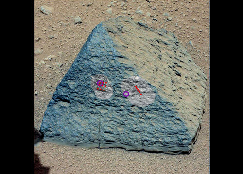
One of the papers additionally focuses on a rock I covered back in the early days of the mission – Jake_M. Named in memory of NASA / JPL engineer Jacob Matijevic, who worked on all three generations of NASA’s Mars rovers and who passed away shortly after Curiosity arrived in Gale Crater, Jake_M was thought to be quite unlike any other rock on Mars – not because of its pyramid-like shape, but because of its composition.
“Jake_M”, the remarkable rock examined by Curiosity on September 22nd 2012, and believed to be a mugearite type of rock. The markings show where ChemCam and APXS were used to examine it
The paper published in Science confirms that Jake_M is most like a mugearite, a type of rock found on islands and rift zones on Earth.
 It’s been fairly quiet as the Mars Science Laboratory (MSL) rover Curiosity continues driving towards the point at which it is hoped the rover can traverse between a line of low-lying sand dunes and start exploring the lower slopes of Aeolis Mons, which NASA has dubbed “Mount Sharp”.