Crossing The Divide in Second Life

The Divide, March 2021

A tweet from Second Life blogger and photographer Rig Torok concerning one of his recent region outings set a bell clanging in the back of my head when it showed up in my time line. It featured an image of, and URL to, a place called The Divide,  was sure we’d visited in the not-to-distant past, but which which failed to show up on my listed of blogged destinations.

That prompted me to rifle through Windows Explorer, and sure enough, there was a folder from December 2019 with a couple of photos of the setting, some rough notes  – and nothing else; so we’d clearly visited, but for whatever reason, had either never fully explored or I’d simply forgotten to go back for photos and write-up thoughts for a post. Hopefully, this piece will therefore make up for things.

The Divide, March 2021

The work of Xen (Xenia Nordberg) and Coriel (Coriel7766), and sitting on a sky platform over a Full private region that leverages the Land Impact bonus, The Divide is described as a study of contrasts, an expression of duality inspired by the works of Hayao Miyazaki.

For those unfamiliar with Miyazaki, he is a Japanese Anime artist, writer, director and producer of animated films. He is internationally regarded as one of the accomplished film-makers and story tellers in the history of animation. His work is characterised by a range of recurrent themes, including humanity’s relationship with nature and technology, elements of which are evident within The Divide, both directly and indirectly.

The Divide, March 2021

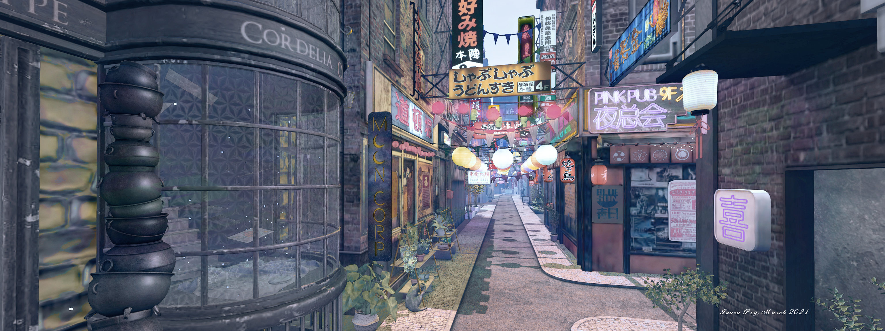
Humanity’s relationship with nature is perhaps most clearly shown in the divide within the setting: to one side, and containing the landing point, sits a very Japanese theme town or village. To the other lies a sinuous, climbing valley, the separator between the two a narrow river channel spanned by bridges.

On the one hand, these two settings speak of both more prevalent aspect of our relationship with nature in our standing apart from it in our towns and cities of concrete and glass whilst constraining its presence to parks and gardens. On the other it represents our underlying need to embrace nature and the escape it can offer in its open spaces and amongst its flora and fauna.

The Divide, March 2021

The town itself is a marvellously compact affair that packs a lot into it, which  admittedly can make moving through it a little heavy going thanks to things like texture loads; I found it easier to disable shadow rendering entirely other than when actually taking snapshots, just to get the textures to load in a little faster and to offer smoother walking / camming. Streets run between an assorted collection of buildings, bunting and lanterns stretched overhead as if for a festival, a subway station hinting at a connection with places further afield whilst hiding a surprise.

While a good number of the town’s buildings are simple façades, others offer interiors to be explored, adding depth to the setting’s sense of place. Little side gardens may also await discovery, again harking back to the idea of our relationship with nature in the manner they offer retreats from the hustle of the street life just a few metres away. An interesting curio sits on the west side of the town: a mushroom-like rock rising above the surrounding buildings, topped by an ancient ruin that is itself home to a able-top D&D style game.

The Divide, March 2021

The human / technology reference is also much in evidence throughout, from the very obvious – all the neon signage, the vehicles, and so on – to the more subtle (anyone spot the reference to a certain film franchise focused on technology?). There’s also the pointers to the speed of modern life such as the “fast food” kiosks for grabbing a bite while on the move, countered by little temple-like places where life can be put on pause and more spiritual matters addressed.

Across the water, the valley and parkland offers the means to escape and explore and presents an interesting mix of themes and ideas. There are Chinese elements such as the of pandas in their bamboo copse, for example, and more studies in our relationship with nature, notably typified by the little shrines along the path that climbs up into the hills.

The Divide, March 2021

To the south of the setting, beyond a bamboo curtain sits a ramshackle home. Reached via a concrete bridge, it again echoes the ideals of relationship: humans living within nature, with our relationship with technology represented through the use of a converted shipping container for the house – the same kind of contain that is used to transport all our little electronic and computerised gizmos around the globe aboard massive ships guided by satellites circling the world high overhead.

Some of the landscaping along the valley and its climbs could perhaps do with a little tidying up, but as long as you follow the paths and steps, you shouldn’t have too much of an issue in finding your way around. Make your way all the way to the top of the steps that wind up through the head of the valley, a zipline awaits to offer a faster way back down – just mind the trees on your way!

The Divide, March 2021

Rich in detail, expressive in design, The Divide presents a lot to be discovered and enjoyed. My thanks to Rig for the reminder.

Slurl Details

Space Sunday: vistas of Mars and more on rockets

Released on March 5th, 2021, this image was captured on February 22nd, 2021 (Sol 4), using the Mastcam-Z system on NASA’s Perseverance rover. It shows a raised section of outflow delta sediments approximately 2.3 km west of “Octavia E. Butler Landing”, where the rover touched down. It was likely formed by material carried into the crater by flowing water that gradually settled as the flow of water met the calmer waters of the crater lake. The remnant is approximately 25-30m high and some 200m across at its base, as indicated by the horizontal scale. Beyond it can be seen the crater wall forming the backdrop to the image. Credit: NASA/JPL

NASA’s Mars 2020 Perseverance rover has spent a further week prepping itself to commence full-time operations on Mars, while also clocking up a distance of 90+ metres while further exercising its driving skills. The mission has also started honouring the Navajo people and their language.

Prior to the mission launching, the science team divided the anding site in Jezeo Crater into a grid with each cell covering an area of 1.5 square kilometres and after a US national park exhibiting similar geology. The plan was to compile a list of names inspired by each cell’s national park that could be used to name features observed by Perseverance. However, as the rover landed in the cell named for Arizona’s Canyon de Chelly National Monument (Tséyi’ in Navajo), in the heart of the Navajo Nation, the mission team reached out to the Navajo Nation through team member Aaron Yazzie, himself a Navajo (or Diné), to seek their permission and collaboration in naming new features on Mars.

Navajo Nation President Jonathan Nez, Vice President Myron Lizer enthusiastically agreed to the idea and worked with advisers to make an initial list of 50 words in the Navajo language that could be used by the rover’s team in  dubbing surface features imaged by the rover.

The partnership that [we have] built with NASA will help to revitalize our Navajo language. We hope that having our language used in the Perseverance mission will inspire more of our young Navajo people to understand the importance and the significance of learning our language. Our words were used to help win World War II, and now we are helping to navigate and learn more about the planet Mars.

Navajo Nation President Jonathan Nez

“Máaz” (Navajo for “Mars”) is currently the first target for scientific study by Perseverance. Credit: NASA/JPL

These names have already started to be used, and more are being added to the list. There is, however a complication: the accent marks used in the English alphabet to convey the unique intonation of the Navajo language cannot be read by the computer languages Perseverance uses. So instead, the science team is working with the Navajo to produce unaccented phonetic representations of the names which the rover can interpret.

The first of the Navajo names to be used is “Máaz” (the Navajo word for Mars – or “Maaz” to the rover). It has been applied to the first target for study by the rover, a large, flat rock the rover is due the commence studying soon. A second rock, dubbed “Yeehgo” (Yéigo in Navajo) has been used as a test subject for the rover’s SuperCam.

“Yeehgo” some 3.1m from the rover was used as a test subject for the SuperCam imager system and lasers on March 10th (Sol 16), during the rover’s driving operations. This images so the image contrasts from Navcam imagers (main picture) to Mastcam-Z (lower right) and Supercam mosaic of 2 images.Credit: NASA/JPL

Developed jointly by the Los Alamos National Laboratory (LANL) in New Mexico and a consortium of French research laboratories under the auspices of French space agency CNES, SuperCam is an instrument suite that can provide imaging, chemical composition analysis, and mineralogy in rocks and regolith from a distance. It comprises two lasers that can “zap” rocks and other features multiple times per second while using it imaging system and four spectrometers to analyse the vapour and dust given off by the laser strikes to determine the composition of the material struck and potentially identify bio-signatures and assess the past habitability of the rock.

“Yeehgo” was used as a means of testing the resolution of the Remote Micro-Imager (RMI) on the SuperCam system, with the rover’s high-resolution Mastcam and Navcam systems (both of which are mounted on the rover’s mast just below the SuperCam) also capturing images for context. The rock was also a target for the laser systems, which the on-board microphones picked up as they fired, the lasers sounding like a fast swinging Newton’s Cradle (sorry, no “pew-pew!” from Mars).

Since departing “Octavia E. Butler Landing” the rover has been scouting locations of interest,  in particular looking for an area when it might safely drop off the Ingenuity drone helicopter. The latter is intended to complete its test flights in the first 30-60 days of the mission in order to free-up the rover so it can drive much further afield and get on with its primary science mission in earnest.

Along the way, Perseverance paused to take in objects such as the rocks mentioned above, and to perform checks of its underside using the imaging systems on its robot arm, checking on the ejection of the “belly pan” covering the underside caching system that will deposit samples of rock and material for collection by a future sample-return mission.

I’ll have more on the Mars 2020 mission over the coming weeks.

Left: March 12th (Sol 18), the imaging system on the rover’s robot arm is used to check the underneath of the vehicle ahead of the release of the belly pan (outlined) covering the sample caching system. The four forward cameras of the Hazcam system can be seen at the top of the picture. Right: March 13th (Sol 19), a view from the rover’s rear Hazcam system images the belly pan on the ground as the rover resumes its drive. Credit: NASA/JPL

Continue reading “Space Sunday: vistas of Mars and more on rockets”