Space Sunday: Perseverance, SN10, and a little bit more

Part of a 360º panorama of Jezero Crater stitched together from 79 individual images captured by the high-resolution Mastcam-Z right-eye 110-mm zoom camera, captured on the afternoon of Sol 4 (Feb. 22nd, 2021). Credit: NASA/JPL

NASA is continuing to get the Mars 2020 rover Perseverance ready to commence science operations, with the past week has seen a number of milestones achieved – including the rover’s first drive on the surface of Mars.

Immediately following the post-landing check-outs, mission controllers were focused on swapping out the Entry Descent and Landing (EDL) software on the rover for the software that will be central to its surface operations. This work was completed on Friday, February 26th – Sol 8 on Mars for the rover. This paved the way for this week’s check-outs of systems.

On Sunday, February 28th, commands were sent to deploy the Mars Environmental Dynamics Analyser (MEDA). Located on the rover’s mast, this comprises two extensible booms and forms the rover’s “weather station”, a set of sensors that measure temperature, wind speed and direction, pressure, relative humidity, radiation, and dust particle size and shape, provided by Spain’s Centro de Astrobiología.

Created from a series of NavCam images recorded on February 28th, this .GIF reveals the deployment of one of the Mars Environmental Dynamics Analyser (MEDA) booms on Perseverance Mars rover. Credit: NASA/JPL

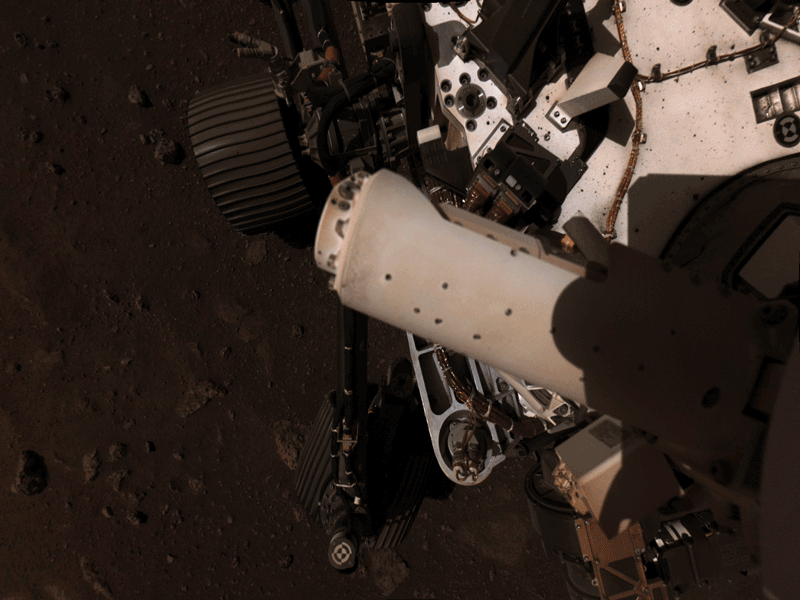
Following this, on Tuesday, March 12th (Sol 12 for the rover), the robot arm was put through its initial paces.

As with Curiosity, the robot arm on Perseverance forms a key part of its science and physical capabilities. At over two metres in length, it has 5 degrees freedom of movement, and ends with a 45 kg “turret” that carries numerous tools and instruments, including:

For its first use, the arm was extended from its cradle and raised to the vertical before being “wriggled” back and forth to confirm instrument stability. It was then lowered and put through a set of rotational moves (as was the instrument turret), before being returned to its cradle and the turret again rotated in two directions.

Images of the rover’s robot arm being put through a basic set of movements. The white “box” on the turret is the PIXL spectrometer, To the right of that is the sample / drill system and on the far side of the turret relative to PIXL is the SHERLOC / WATSON combination. Credit: NASA/JPL
Tuesday’s first test of the robotic arm was a big moment for us. That’s the main tool the science team will use to do close-up examination of the geologic features of Jezero Crater, and then we’ll drill and sample the ones they find the most interesting. When we got confirmation of the robotic arm flexing its muscles, including images of it working beautifully after its long trip to Mars – well, it made my day.

– Robert Hogg, Mars 2020 rover deputy mission manager

A further significant milestone was marked on March 4th (Sol 14), when the rover made that first drive. While covering less then eight metres, it was enough for the rover to perform a few basic manoeuvres intended to allow the engineering team to check-out the rover’s basic mobility capabilities.

Perseverance wiggles one of its wheels in this set of images obtained by the rover’s left Navigation Camera on March 4th, 2021. Credits: NASA/JPL

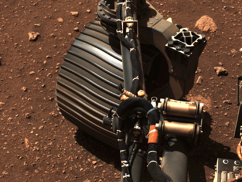
Following a set of initial steering turns of the forward wheels (shown above), the rover drove forward 4 metres before turning 150o whilst standing still. It then reversed a further 2.5 metres to park in a new location. While comparatively short and taking 33 minutes to complete, this first drive is a small taste of what is to come. With its improved navigation and auto-pilot capabilities, Perseverance is  capable of covering up to 200 metres in a single day once surface operations commence.

This was our first chance to ‘kick the tires’ and take Perseverance out for a spin. The rover’s six-wheel drive responded superbly. We are now confident our drive system is good to go, capable of taking us wherever the science leads us over the next two years.

– Anais Zarifian, Mars 2020 rover mobility test bed engineer

This set of images shows parts of the robotic arm on NASA’s Perseverance rover flexing and turning during its first checkout after landing on Mars. These images were taken by the rover’s NavCam systems on March 3rd, 2021. Credits: NASA/JPL

The new parking position gave the mission team an opportunity to look back at the rover’s landing point and examine the surface and how the skycrane motors dispersed dust and regolith. The view also gave the mission team the opportunity to formally name the landing site, as has been done with past missions.

Using a press conference on the rover’s  progress held on Friday, March 5th, members of the Mars 2020 mission team announced the landing site will be known as the “Octavia E. Butler Landing”, named in honour of the African-American science fiction writer, who passed away in 2006.

Whilst not officially recognised by the International Astronomical Union, the body responsible for all official solar system designations, the name reflects the Jet Propulsion Laboratory’s practice of naming key sites for missions after noted scientists and science fiction writers (for example, the Curiosity rover landing site was dubbed “Bradbury Landing” after science fiction author Ray Bradbury, while the mountain it is exploring was dubbed “Mount Sharp” after American geologist Robert P. Sharp).

Depending on how reporting on the initial phases of the rover’s mission is handled by NASA, I’ll continue to update on Perseverance alongside other Mars missions either as a part of Space Sunday, or within a new series I’m debating running. In the meantime, the video below combines views of Jezero Crater captured by the rover’s Mastcam and NavCam systems during the rover’s first week of operations.

Continue reading “Space Sunday: Perseverance, SN10, and a little bit more”

Frogmore’s fourth in Second Life

Frogmore 4.0, March 2021

Tolla Crisp invited Caitlyn and I to visit Frogmore 4.0, the fourth iteration of her popular themed region which recently opened to visitors.

Once again, the setting draws its primary inspiration from the county of Cornwall, in the South-west of England – a place noted for its moors, hamlets, fishing, surfing, beaches and rugged beauty and which was the inspiration for the design we last saw in June 2020 (see Frogmore’s Cornish twist in Second Life). However, the design adds a couple of little twists of its own to the mix as well as offering a completely new look.

Frogmore 4.0, March 2021

Those twists take the form of a corner inspired by London’s Notting Hill, with another part taking the name “The Shire” – although whether this is a reference to Tolkien’s eponymous home of Hobbits or a reference to the shires of England in all their diverse beauty, is open to interpretation.

Now making use of the Land Impact bonus available to full private regions, this iteration has been designed by Dandy Warhlol (Terry Fotherington), who has been responsible for all of the various Frogmore designs. This ensures something of a continuity of approach as the region changes, helping to give it a sense of evolution / life in keeping with the continuing focus on Cornwell for on its inspiration.

Frogmore 4.0, March 2021

With this iteration, the region offers a look and feel of the more rugged parts of Cornwall’s coast that can feature rocky coves with little fishing hamlets tucked into them. Split into a series of islands, there is no set route to finding your way around the region, instead, visitors can wander as they please, causeways and bridges connecting the various areas.

The core influence for this design is the north Cornish fishing village of Port Isaac. It’s a place that may not be familiar to those outside of the UK, but since 2004 it has been the setting for the comedy series Doc Martin, at least one season of which has been streamed in the United States.

Frogmore 4.0, March 2021

It is also the home of Fisherman’s Friends, a male singing group who have been performing sea shanties since 1995. In 2010, they garnered worldwide attention after signing a recording deal with Universal Music, and their story was used as the basis for a 2019 romantic comedy film. The village is also part of the Baltic Live Cam network, with a 24/7 webcam stream.

Listed as a Conservation Area due to the buildings at its centre representing 18th and 19th century architecture, Port Isaac is historically significant, having likely been founded in Celtic times; its Cornish name, Porthysek means “corn port”, reflecting the use of the bay in shipping corn grown inland to centres of populace. It’s importance as a point of trade grew in the Tudor period, when Henry VIII had the bay dredged and the main pier and breakwater constructed. Apart from the corn that gave the town its name, cargoes of coal, wood, stone, ores, limestone, salt, pottery and heavy goods also passed through the harbour.

Frogmore 4.0, March 2021

However, pilchard fishing formed the backbone for the village for most of its history up until the late 1800s, with fishing still part of village life today, together with tourism. A curiosity with Port Isaac is that it shares a stretch of the coast with the hamlet  of Port Gaverne; whilst separated b around a kilometre, the latter is often to be an outlier of the village, something that might be reflected in the way elements of this design stand aside from the rest, but nevertheless appear to be part of the whole.

With its harbour cove caught at low tide complete with breakwater, the heart of the region captures something of Port Isaac’s waterfront look whilst offering a wilder,  more rugged landscape that is not so densely packed with houses and buildings. These are represented by the cluster of houses, barns and public building clustered on the island directly to the north.

Frogmore 4.0, March 2021

The Notting Hill aspect to the region can be found in the south-west corner, where an antiques boutique typical of those found along Portobello Road is waiting to be found. Sitting on a finger of land reached by a covered bridge, it sits separated from the main Cornish village element by The Shire.

This is a location that sits both aside from, yet a part of, the rest of the region. As already noted, whether one takes the area’s name from Tolkien or stands in reflection of England’s shire counties is a matter of choice. Certainly, there are no Hobbit holes waiting to be found, and the buildings, drywalls and gardens are suggestive of places like the Home Counties shires mixed with a dose of Yorkshire and Derbyshire. However, the high mountains surrounding the region – which are definitely not of England – give a New Zealandish feel to the setting, putting one in mind of the likes of Peter Jackson and his iconic visualisation of Middle Earth through his films, and thus call forth thoughts of Hobbits.

Frogmore 4.0, March 2021

As with all of the Frogmore iterations, this setting is rich in opportunities for photography, exploration and simply sitting and enjoying the view. Do be aware, however, that given many of the buildings are furnished, it is a place packed with mesh and textures,  and this can have an impact on viewer performance, so be prepared to make allowances should this be the case.

But that said, from the compact gathering of houses and buildings clinging to the shorelines and cliffs complete with narrow streets, to the sweep of a northern beach overlooked by the ruins of a promontory fort, the richness of the Cornish landscape is hard to deny; while the twists within – the hints of Portobello Road to the touch of the Mediterranean in some of the buildings – make Frogmore a delightfully engaging visit.

Frogmore 4.0, March 2021

To mark the re-opening of the region, Tolla is holding a photography competition with a L$17,500 prize pool, details of which can be found here.

SLurl Details