Space update: seeking planet X, examining comets and sifting sand

Curiosity
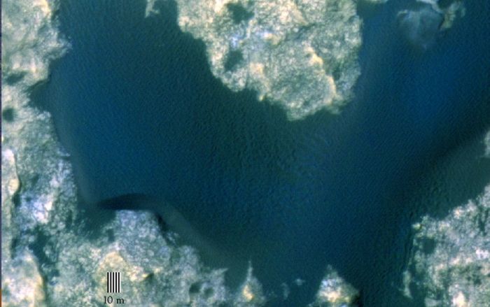
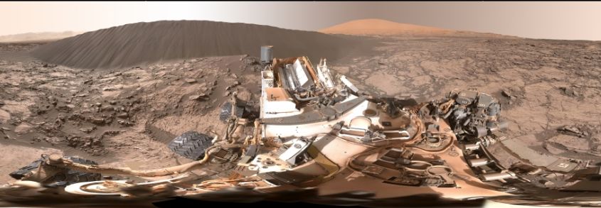
NASA’s Curiosity rover has been sampling the sands of the “Namib Dune” the vehicle has been studying / circumnavigating for the last few weeks as it studies an extensive dune field which is slowly making its way down the slopes of “Mount Sharp” on Mars at the rate of about a metre per year.

“Mount Sharp”, more formally called Aeolis Mons, is the huge mound of material gathered against the central impact peak of Gale Crater. It forms the rover’s primary mission target in its quest to better understand conditions on Mars down through the ages, and to look for areas which at some point in the planet’s past, may have had all the right conditions – minerals, chemicals, water, heat, shelter, etc., – which might have allows life to arise.

The dune field on the north-east flank of “Mount Sharp” is of considerable interest to scientist, as it is the first genuine dune field to be studied on another world, and obtaining a clearer understanding of how the Martian wind moves sand could lead to a clearer picture of how big a role the wind plays in depositing concentrations of minerals often associated with water across the planet, and by extension, the behaviour and disposition of liquid water across Mars.

Tracks on a sand dune: this image from Curiosity's front Hazard Avoidance Camera (Hazcam) shows the rover's tracks on the same of "Namib Dune" as it starts sample gathering
Tracks on a sand dune: this image from Curiosity’s front Hazard Avoidance Camera (Hazcam) shows the rover’s tracks on the same of “Namib Dune” as it starts sample gathering

On January 12th, the rover reached a target area for sample gathering dubbed “Gobabeb”, and even this presented a challenge. Curiosity had to manoeuvre up onto the dune, and then turn in place in order to start sample gathering operations. This meant a cautious approach to the location, initially “scuffing” the sand to obtain and indication of its depth and composition (loose firm material). After this the rover gently edged onto the sand and deployed the robot arm to use its small scoop in only its second major sample gathering exercise, which took place on January 14th.

The sand gathered by the operations well be sorted within the CHIMRA system inside the robot arm, which uses a series of sieves to divide the sand grains by coarseness. Once sorted, the samples are delivered to the rover on-board chemical and analysis systems  – ChemMin, the Chemical and Mineralogical laboratory and SAM, the Sample Analysis at Mars suite – for examination.

A second sample of sand was gathered on January 19th, and is currently awaiting processing.

CHIMRA
CHIMRA – the Collection and Handling for In-Situ Martian Rock Analysis device attached to the turret at the end of Curiosity’s robotic arm, processes samples acquired from the built-in scoop (red) and the drill, which is not shown but is also part of the turret. CHIMRA also delivers samples to the analytical lab instruments inside the rover. Two paths to get material into CHIMRA are shown (the scoop delivers material to the location marked at the bottom, and the drill deposits material to the sample transfer tube shown at top). Also marked are the location of the vibration mechanism used to shake the turret and cause the sample to move inside CHIMRA, and the portion box (yellow) from which the material processed through a sieve is delivered to the analytical lab instruments.

Europe Joins Dream Chaser

In my last Space Sunday report, I covered the news that Sierra Nevada Corporation (SNC) will be joining SpaceX and Orbital ATK in supporting US work to delivery supplies to, and remove waste from, the International Space Station.

As a part of a new contract which commences in 2019 and runs until 2024, the expected end of ISS operations, SNC will utilise an unmanned cargo version of its Dream Chaser “mini shuttle”, which is based on a lifting body design, to carry up to 5 tonnes of material to the space station. Now Europe has officially joined SNC as a strategic partner.

The Drem Chaser Cargo, bult by SNC, and the International Berth and Docking Mechanism, to be supplied to SNC for Dream Chaser flights by the European Space Agency
The Dream Chaser Cargo, built by SNC, and the International Berth and Docking Mechanism, to be supplied to SNC for Dream Chaser flights by the European Space Agency

SNC and Europe have been looking at options for Dream Chaser development since SNC lost out to SpaceX and Boeing to supply the crewed version of Dream Chaser to NASA for ferrying crews back and forth between the ISS and US soil. Confirmation that NASA will be using Dream Chaser for the resupply flights means that ESA can nor push ahead with developing an International Berthing and Docking Mechanism (IBDM) for Dream Chaser.

Continue reading “Space update: seeking planet X, examining comets and sifting sand”

Space Sunday: dunes, rockets and asteroids

CuriosityNASA’s Mar Science Laboratory rover, Curiosity, continues to perform the first up-close study ever conducted of extraterrestrial sand dunes as it slowly explores the slopes of “Mount Sharp” dubbed the “Bagnold Dunes”.

Located on the north-west slope of the mound which lies at the centre of Gale Crater, the dunes differ from those drifts and sand fields the rover has previously encountered on Mars in terms of both their size and height – some cover an area the size of a football field and are 2 storeys high – and their general shape, something which marks them out as “classic” sand dunes.

This latter point is most evident by the dunes exhibiting a steep, downwind slope, referred to as the slip face, and which exhibits certain features of its own, such as gain fall, ripples and grain flow, as well as the dune as a whole exhibiting typical features such as the horn and toe.

For the last couple of weeks, the rover has been working its way around one dune in particular, dubbed “Namib”, which is somewhat smaller than the “high dunes” images at the start of December, but which still rises to a height of some 5 metres (16 ft). The leeward side of “Namib” in particular demonstrates the classic features of a sand dune, and helps to confirm the fact that the dunes are slowly progressing down the slope of “Mount Sharp” at a rate of about 1 metre (39 inches) a year.

The leeward side of Namib:
The leeward side of “Namib”:Horn – where sand is escaping the main dune and escaping downhill, as indicated by the ripples; Toe – the downwind extent of the dune; ripples – signs of the sand bouncing sideways over the dune as the wind blows it downslope towards the horn;  Brink – the ridge between the windward, gentle slope of the dune and the leeward, steeper slope of the dune; Grail Fall – areas where sand is blown / falls from the brink and comes to rest on the leeward slope; Gain Flow – tongue-like area indicating where large amounts of sand have slumped down the side of the dune towards the toe, again indicative of a dune in motion

The dune-investigation campaign is designed to increase understanding about how wind moves and sorts grains of sand in an environment with less gravity and much less atmosphere than well-studied dune fields on Earth. Such an understanding of how the wind moves sand could lead to a clearer picture of how big a role the Martian wind played in depositing concentrations of minerals often associated with water across the planet, and by extension, the behaviour and disposition of liquid water across Mars.

This rather odd-looking image is a foreshortened 360-degree view of the area around Curiosity. In the immediate foregound is the rover's main deck, with the cylindrical, finned nuclear RTG at the back of it. Beyond this is the "Namib" dune, with a taller dune beyond it. The view was constructed froma series of images taken by the rover's Mastcam on December 18th, 2015 (Sol 1,197 on Mars), all of which have been white-balanced to present the view under normal Earth daylight conditions
This rather odd-looking image is a foreshortened 360-degree view of the area around Curiosity. In the immediate foreground is the rover’s main deck, with the cylindrical, finned nuclear RTG at the back of it. Beyond this is the “Namib” dune, with a taller dune beyond it. The view was constructed from a series of images taken by the rover’s Mastcam on December 18th, 2015 (Sol 1,197 on Mars), all of which have been white-balanced to present the view under normal Earth daylight conditions

Back to Sea for SpaceX

SpaceX, the private space launch company, is keeping itself busy. Following the successful launch of the Orbcomm mission from Florida’s Cape Canaveral Air force Station, together with the successful recovery of the first stage of the booster when it flew back to the Cape and performed a flawless vertical landing, the company’s next launch is scheduled for Sunday, January 17th.

The launch will take place from Vandenberg Air force Base, California, which is the company’s Pacific Coast launch operations centre. The primary aim of the mission is to place the third in a series of joint U.S.-European satellites into a near-polar orbit (for which Vandenberg AFB is ideally suited, as a polar launch from there does not pass over inhabited land during ascent, lessening the risk to human lives should a launch vehicle suffer a failure).

The Jason-3 series of missions is part of a very long-term series of studies (started in 1992) to study the topography of the ocean surface (i.e. the formation and movement of waves and the troughs between them), which can provide scientists with critical information about circulation patterns in the ocean, and about both global and regional changes in sea level and the climate implications of a warming world.

Jason-3, the latest in a series of joint US-European satellites studying the topography of the ocean's surface, is due for launch on December 17th, 2016, using a SpaceX Falcon 9 1.1 rocket
Jason-3, the latest in a series of joint US-European satellites studying the topography of the ocean’s surface, is due for launch on December 17th, 2016, using a SpaceX Falcon 9 1.1 rocket (image: NASA / CNES)

The polar orbit used for this kind of earth-observing mission, being almost perpendicular to the Earth’s rotation, allows the spacecraft to at some point travel over almost every part of the world’s oceans, vastly increasing its ability to gather data when compared to a vehicle in an equatorial orbit.

What is also significant about the mission is that it will use a SpaceX Falcon 9 1.1 booster, the first stage of which will once again attempt to return to Earth and make a safe landing. However, unlike the December 2015, this landing will once again be at sea, using a SpaceX droneship landing platform.

Continue reading “Space Sunday: dunes, rockets and asteroids”

Space Update: silica mysteries, Brits in space and tracking Santa

new-horizonNew Horizons is still less than half way through transmitting the data gathered during its fly-past of the Pluto-Charon system in July 2015, but the wealth of information received thus far has already revealed much about Pluto and its “twin”.

Geological evidence has been found for widespread past and present glacial activity, including the formation of networks of eroded valleys, some of which are “hanging valleys,” much like those in Yellowstone National Park, Wyoming. A major part of this activity is occurring in and around “Sputnik Planum”, the left half of Pluto’s “heart”, a 1,000 km (620 mile) wide basin, which is seen as key to understanding much of the current geological activity on Pluto.

Images and data gathered for this region has given rise to new numerical models of thermal convection with “Sputnik Planum”, which is formed by a deep layer of solid nitrogen and other volatile ices. These not only explain the numerous polygonal ice features seen on Sputnik Planum’s surface, but suggest the layer is likely to be a few kilometres in depth.

Evaporation of this nitrogen, together with condensation on higher surrounding terrain is believed causing a glacial flow from the higher lands back down into the basin, where the ice already there is pushed, reshaping the landscape over time.

A ture colour image of Pluto's surface, captures just before the point of closest approach, and created by combining black-and-while images from from the LORRI camera with data gathered by the Ralph instrument suite. The picture show the highlands to one side of "Sputnik Planum with the pockmarked ices of the basin. A combination of evaporation and condensation between the two is giving rise to sustained glaciation on Pluto, showing it to be an active world
A true colour image of Pluto’s surface, captures just before the point of closest approach, and created by combining black-and-while images from from the LORRI camera with data gathered by the Ralph instrument suite. The picture show the highlands to one side of “Sputnik Planum” with the pockmarked ices of the basin. A combination of evaporation and condensation between the two is giving rise to sustained glaciation on Pluto, showing it to be an active world (image: NASA, JHU/APL SwRI)

More data and images have also been received regarding Pluto’s atmosphere, allowing scientists start to probe precisely what processes are at work in generating and renewing the atmosphere, the upper limits of which are subject to erosion by the solar wind, which strike Pluto at some 1.4 million kilometres per hour (900,000 mph).

As well as understanding the processes which are at work renewing the atmosphere, and thus preventing it from being completely blasted away by the solar wind, science teams are hoping to better further why the haze of Pluto’s atmosphere forms a complicated set of layers – some of which are the result of the formation and descent of tholins through the atmosphere – and why it varies spatially around the planet.

The Mars Silica Mystery

In July I covered some of the work going into investigating the mystery of silica on Mars. This is a mineral of particular interest to scientists because high levels of it within rocks could indicate conditions on Mars which may have been conducive to life, or which might preserve any ancient organic material which might be present. In addition.

As I reported back in July, scientists have been particularly interested in the fact that as Curiosity has ascended “Mount Sharp”, so have the amounts of silica present in rocks increased: in some rocks it accounts for nine-tenths of their composition. Trying to work out why this should be, and identifying the nature of some of the silica deposits has given rise to a new set of mysteries.

The first mystery is trying to understand how the silica was deposited – something which could be crucial in understanding how conducive the environment on “Mount Sharp” might have been for life. Water tends to contribute to silica being deposited in rocks in one of two ways. If it is acidic in nature, it tends to leach away other minerals, leaving the silica behind. If it is more neutral or alkaline in nature, then it tends to deposit silica as it filters through rooks.

This May 22, 2015, view from the Mast Camera (Mastcam) in NASA's Curiosity Mars rover shows the "Marias Pass" area where a lower and older geological unit of mudstone -- the pale zone in the center of the image -- lies in contact with an overlying geological unit of sandstone. This view from the Mast Camera (Mastcam) in NASA's Curiosity Mars rover shows the "Marias Pass" area where a lower and older geological unit of mudstone -- the pale zone in the center of the image -- lies in contact with an overlying geological unit of sandstone. Just before Curiosity reached Marias Pass, the rover's laser-firing Chemistry and Camera (ChemCam) instrument examined a rock found to be rich in silica, a mineral-forming chemical. This scene combines several images taken on May 22, 2015, during the 992nd Martian day, or sol, of Curiosity's work on Mars. The scene is presented with a color adjustment that approximates white balancing, to resemble how the rocks and sand would appear under daytime lighting conditions on Earth.
This mosaic of images captures by Curiosity’s Mastcam on May 22nd 2015 (Sol 992), shows the “Marias Pass” region where mudstone (the pale rock in the centre of the image) of the kind the rover had been studying, overlaid by a geological unit of sandstone. rocks in this area should very high concentrations of silica in them, much higher than previously encountered, which the rocks above the area show strong evidence of silica deposition as a result of water action. This image has been white balanced to show the rock under Earth equivalent natural lighting conditions (image: NASA / JPL)

If the water which once flowed down / through “Mount Sharp” was acidic in nature, it would likely mean that the wet environments found on the flanks of the mound were hostile to life having ever arisen there or may have removed any evidence for life having once been present. If evidence that the water was acidic in nature, then it would also possibly point to conditions on “Mount Sharp” may have been somewhat different to those found on the crater floor, where evidence of environments formed with more alkaline water and with all the right building blocks for life to have started, have already been discovered.

The second mystery with the silica is the kind of silica which has been discovered in at least one rock.  Tridymite is a polymorph of silica which on Earth is associated with high temperatures in igneous or metamorphic rocks and volcanic activity. Until Curiosity discovered significantly high concentrations of silica in the “Marias Pass area of “Mount Sharp” some seven months ago – something which led to a four month investigation of the area – tridymite had never been found on Mars.

The region just above "Marias Pass" contained an area referred to as the "Stimson Unit" which showed fracturing rich in silica when compared to the surrounding rocks, suggesting deposition of silica / leaching of other minerals as a result of water action
The region just above “Marias Pass” contained an area referred to as the “Stimson Unit” which showed fracturing rich in silica when compared to the surrounding rocks, suggesting deposition of silica / leaching of other minerals as a result of water action (images: NASA / JPL)

“Marias Pass” and the region directly above it, called the “Stimson Unit” show some of the strongest examples of silica deposition on “Mount Sharp”, and  it was in one of the first rocks, dubbed “Buckskin”, exhibiting evidence of silica deposits in which the tridymite was found.

The question now is: how did it get there? All the evidence for the formation of “Mount Sharp” points to it being sedimentary in nature, rather than volcanic. While Mars was very volcanic early on in its history, the presence of the tridymite on “Mount Sharp” might point to volcanic /  magmatic evolution on Mars continuing for longer than might have been thought, with the mineral being deposited on the slopes of the mound as a result of wind action. Or alternatively, it might point to something else occurring on Mars.

Continue reading “Space Update: silica mysteries, Brits in space and tracking Santa”

Space Sunday: clouds, sand, meteors and launches

Artist's impression of Akatsuki in orbit around Venus
Artist’s impression of Akatsuki in orbit around Venus

In my last Space Sunday update, I was writing at the very time a final effort was being made to see a little Japanese space probe finally achieve an operational orbit around Venus, precisely five years to the date after the first attempt failed as a result of the craft’s primary motor malfunctioning.

At the time of writing that update, it appeared as if little Akatsuki (“Dawn”), designed to probe the Venusian climate and atmosphere had finally arrived in orbit about the planet, but as I noted, final confirmation would take a while.  In the end, it wasn’t until Wednesday, December 9th that the Japan Aerospace eXploration Agency (JAXA) did confirm Akatsuki, less than a metre on a side (excluding its solar panels) was secure in its orbit around Venus and would likely be able to complete its mission.

Following the failure of its main engine on December 7th 2010 during a critical braking manoeuvre, the probe had finished up in a heliocentric orbit, circling the sun and heading away from Venus. However, orbital mechanics being as they are, both the probe and Venus would occupy the same part of space once again in December 2015, presenting final opportunity to push the probe into orbit using its RCS manoeuvring thrusters. This is precisely what happened on the night of December 6th / 7th, 2015. While not designed for this purpose, a set of the probe’s RCS thrusters undertook a 20-minute burn just before midnight UTC on December 6th, and preliminary telemetry received on Earth some 30+ minutes later showed Akatsuki had achieved sufficient braking to enter a very elliptical orbit around Venus.

A simple orbital diagram released as a part of the low-key JAXA press release confirming Akatsuki had arrived in orbit around Venus
A simple orbital diagram released as a part of the low-key JAXA press release confirming Akatsuki had arrived in orbit around Venus (image: JAXA)

Data received since then show that the craft is in an eccentric orbit with an apoasis altitude (the point at which it is furthest from the surface of Venus) of around 440,000km, and a periapsis altitude (the point at which it is closest to the surface of Venus) of around 400km. This is a considerably broader orbit than the mission had originally intended back in 2010, giving the vehicle an orbital period of around 13.5 days, the orbit slightly inclined relative to Venus’ equator.

An ultra-violet image of Venus, returned by Akatsuki shortly after achieving its initial orbit around the planet, and having passed through periapis, already heading away from the planet
An ultra-violet image of Venus, returned by Akatsuki shortly after achieving its initial orbit around the planet, having passed periapsis during the braking manoeuvre, to head away from the planet (image: JAXA)

In order to maximise the science return from the vehicle – which is now operating well in excess of its designed operational life – JAXA plan to use the next few months to gradually ease Akatsuki in an orbit which reduces both the apoasis distance from Venus, and bring down the orbital period to about 9 days.

These manoeuvres will likely be completed by April 2016, allowing the full science mission to finally commence.  This is aimed at learning more about the atmosphere and weather on Venus as well as confirm the presence of active volcanoes and thunder, and also to try to understand exactly why  Earth and Venus developed so differently from each other, despite being seen as sister planets in some regards.

Even so, right from its arrival in its initial orbit, Akatsuki has been flexing its muscles, testing its imaging systems and returning a number of preliminary pictures of Venus to Earth, such as the ultra-violet image shown above right, captured just after the craft finally achieved orbit.

Curiosity reaches Sea of Sand

NASA’s Mars Science Laboratory rover Curiosity has reached the edge of the major “sea” of sand dunes located on the flank of “Mount Sharp”. Dubbed the ““Bagnold Dunes” after British military engineer Ralph Bagnold, who pioneered the study of sand dune formation and motion, doing much to further the understanding of mineral movements and transport by wind action. Such studies are seen as an essential part of understanding how big a role the Marian wind played in depositing concentrations of minerals often associated with water across the planet, and by extension, the behaviour and disposition of liquid water across Mars.

Sand is not a new phenomenon for rovers on Mars to encounter – Curiosity, Opportunity and Spirit have all had dealings with it in the past; in fact Spirit’s mission as a rover came to an end in 2009, after it effectively got stuck in a “sand trap”. However, the “Bagnold Dunes” are very different to the sandy environs previously encountered by rovers; it is a huge “genuine” dune field where the sand hills can reach the height of 2-storey buildings and cover areas equivalent to an American football field.

The rippled surface of the first Martian sand dune ever studied up close. Captured by Curiosity's Mastcam on November 27th, 2015 (Sol 1,176 on Mars), the view is looking up the curved slope of "High Dune", revealing a rippled surface of sand sculpted by the wind. The Bagnold dunes" are "active", in that they are migrating down the slope of "Mount Sharp" at the rate of around one metre (39 inches) a year. The dunes are active, migrating up to about one yard or meter a year.
The rippled surface of the first Martian sand dune ever studied up close. Captured by Curiosity’s Mastcam on November 27th, 2015 (Sol 1,176 on Mars), looking up the curved slope of “High Dune” as it rises above Curiosity. The “Bagnold Dunes” are “active”, in that they are migrating down the slope of “Mount Sharp” at the rate of around one metre (39 inches) a year  (image: NASA / JPL)

So far, Curiosity has only probed the edge of the dune field around a sand hill originally dubbed “Dune 1”, and now called “High Dune”, using both its camera to image the region and its wheels to test the surface material prior to moving deeper into the sands. Wheel slippage is a genuine concern for the rover when moving on loose surfaces, as it can both overtax the motors and put the rover at risk of toppling over. Given this, and while there are no plans to attempt any ascent up the side of a dune, the mission team are taking things cautiously.

Continue reading “Space Sunday: clouds, sand, meteors and launches”

Space Sunday: the sand dunes of Mars and flying to the ISS

Curiosity
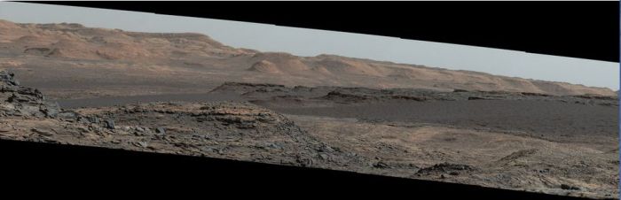
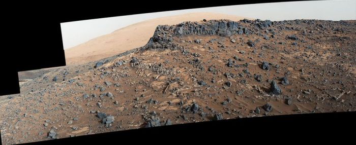
The Mars Science Laboratory rover, Curiosity, continues to climb the flank of “Mount Sharp” (formal name: Aeolis Mons), the giant mount of deposited material occupying the central region of Gale Crater around the original impact peak. For the last three weeks it has been making its way slowly towards the next point of scientific interest and a new challenge – a major field of sand dunes.

Dubbed the “Bagnold Dunes”, the field occupies a region on the north-west flank of “Mount Sharp”, and are referred to as an “active” field as they moving (“migrating” as the scientists prefer to call it) down the slops of the mound at a rate of about one metre per year as a result of both wind action and the fact they are on a slope.

Curiosity has covered about half the distance between its last area of major study and sample gathering and the first of the sand dunes, simply dubbed “Dune 1”. During the drive, the rover has been analysing the samples of rock obtained from its last two drilling excursions  and returning the data to Earth, as well as undertaking studies of the dune field itself in preparation for the upcoming excursion onto the sand-like surface.

While both Curiosity and, before it, the MER rovers Opportunity and Spirit have travelled over very small sand fields and sand ripples on Mars, those excursions have been nothing like the one on which Curiosity  is about to embark; the dunes in this field are huge. “Dune 1”, for example, roughly covers the area of an American football field and is equal in height to a 2-storey building.

"dune 1" in the "Bagnold Dunes", imaged here by the High Resolution Imaging Science Experiment (HiRISE) camera on NASA's Mars Reconnaissance Orbiter (MRO) is roughly 300 metres across and as tall as a 2-storey building. The image is in false color, combining information recorded by HiRISE in red, blue-green and infrared frequencies of light.
“dune 1” in the “Bagnold Dunes”, imaged here by the High Resolution Imaging Science Experiment (HiRISE) camera on NASA’s Mars Reconnaissance Orbiter (MRO) is roughly 300 metres across and as tall as a 2-storey building. The image is in false colour, combining information recorded by HiRISE in red, blue-green and infra-red frequencies of light.

While the rover will not actually be climbing up the dune, it will be traversing the sand-like material from which it is formed and gathering samples using the robot arm scoop. This is liable to be a cautious operation, at least until the mission team are confident about traversing parts of the dune field – when Curiosity has encountered Martian sand in the past, it has not always found favour; wheel slippage and soft surfaces have forced a retreat from some sandy areas the rover has tried to cross.

Study of the dunes will help the science team better interpret the composition of sandstone layers made from dunes that turned into rock long ago, and also understand how wind action my be influencing mineral deposits and accumulation across Mars.

On Earth, the study of sand dune formation and motion, a field pioneered by British military engineer Ralph Bagnold – for whom the Martian dune field is named – did much to further the understanding of mineral movements and transport by wind action.  Understanding how this might occur on Mars is important in identifying how big a role the Marian wind played in depositing concentrations of minerals often associated with water across the planet, as opposed to those minerals accumulating in those areas as a direct consequence of water once having been present.

A mosaic of images taken on September 25th, 2015 (Sol 1,115) captures by the right lens of the rover's Mastcam system. .The view is toward south-south-west and reveals the "Bagnold Dunes" as a dark band across the middle of the image, blending with mesas beyond them
A mosaic of images taken on September 25th, 2015 (Sol 1,115) captures by the right lens of the rover’s Mastcam system. .The view is toward south-south-west and reveals the “Bagnold Dunes” as a dark band across the middle of the image, blending with mesas beyond them

Next NASA Rover to Have its Own Drone?

In January I wrote about ongoing work to develop a helicopter “drone” which could operate in concert with future robot missions to Mars. Now the outgoing director of NASA’s Jet Propulsion Laboratory has indicated the centre would like to see such a vehicle officially included as a part of the Mars 2020 rover package.

Weighing just one kilogramme (2.22 pounds) and with a rotor blade diameter of just over a metre (3.6 feet), the drone would be able to carry a small instrument payload roughly the size of a box of tissues, which would notably include an imaging system. Designed to operate as an advanced “scout”, the drone would make short daily “hops” ahead of, and around the “parent” rover to help identify safe routes through difficult terrain and gather data on possible points of scientific interest which might otherwise be missed and so on.

Since January, JPL has been continuing to refine and improve the concept, and retiring JPL Director Charles Elachi has confirmed that by March 2016, they will have a proof-of-concept design ready to undergo extensive testing in a Mars simulation chamber designed to reproduce the broad atmospheric environment in which such a craft will have to fly. The centre hopes that the trials will help convince NASA management – and Congress – that such a drone would be of significant benefit to the Mars 2020 mission, and pave the way for developing drones which might be used in support of future human missions on the surface of Mars.

Continue reading “Space Sunday: the sand dunes of Mars and flying to the ISS”

Sunday Sunday: Mars, Pluto and WTF hits the atmosphere

CuriosityMars has been in the news a lot this last week, thanks to both the Curiosity rover and the MAVEN orbiter.

Curiosity’s science capabilities received a boost when a upgrade to the ChemCam test system on Earth increased the number of Earth-rock geochemical samples examined by the system tripled to some 350, vastly increasing the science team’s ability to improve their interpretation of data gathered by Curiosity’s ChemCam system – the laser and telescope / camera which vaporises small amounts of rocks on Mars and them images the plasma that’s given of for chemical and mineralogical analysis.

In particular, the upgrade has allowed the science team to re-examine data the rover gathered about a site with the most chemically diverse mineral veins so far examined on Mars. Called “Garden City”, the site sits above the “Pahrump Hills” area at the foot of “Mount Sharp”, which the rover examined in detail in late 2014 / early 2015. Of particular interest to scientists were a series of raised mineral veins criss-crossing the surface of the rocks in the area.

"Garden City", an outcrop about 1 metre (39 inches) high, examined by Curiosity in March 2015, and which exhibited mineral veins criss-crossing the surface of the rocks, and which exhibited different chemical signatures. New analysis capabilities on Earth have helped determine how the veins formed and what they may say about early conditions in Gale Crater.
“Garden City”, an outcrop about 1 metre (39 inches) high, examined by Curiosity in March 2015, and which exhibited mineral veins criss-crossing the surface of the rocks, and which exhibited different chemical signatures. New analysis capabilities on Earth have helped determine how the veins formed and what they may say about early conditions in Gale Crater

These new Earthside capabilities have allowed the science team to better analyse the minerals within the veins and make finer distinctions between them, revealing their mineral and chemical compositions vary one to another, and also appear to vary with age.

These findings suggest that, rather than being the result of a single extended wet period in Gale Crater during which water percolated down through fissures in the rock to leave the minerals behind, the veins are the result of several individual wet periods in Mars’ ancient past. These wet periods appear to have occurred somewhat later than the more extensive wet periods which gave rise to a successive series of lakes within Gale Crater, the sediments from which form the lowest slopes of “Mount Sharp”. As such, the veins give further hints to atmospheric changes going on at a time at which Mars’ climate was undergoing extraordinary changes and fluctuations in its ancient past.

Prominent mineral veins at the "Garden City" site examined by NASA's Curiosity Mars rover vary in thickness and brightness, as seen in this image from Curiosity's Mast Camera (Mastcam). The image covers and area roughly 2 feet (60 centimeters) across. Types of vein material evident in the area include: 1) thin, dark-toned fracture filling material; 2) thick, dark-toned vein material in large fractures; 3) light-toned vein material, which was deposited last.
Prominent mineral veins at the “Garden City” site examined by NASA’s Curiosity Mars rover vary in thickness and brightness, as seen in this image from Curiosity’s Mast Camera (MastCam).  The image covers and area roughly 60 cm (24 inches) across, and shows a mix of thin, dark-toned fracture filling material, likely deposited first, thick, dark-toned vein material in large fractures, and light-toned vein material, which was deposited last.

What Happened to Mars’ Atmosphere? The Answer is Blowin’ in the Wind

Atmospheric changes are also at the heart of the latest data to be analysed from NASA’s Mars Atmosphere and Volatile Evolution (MAVEN). This data, part of the mission’s long terms studies of the planet’s atmosphere and environment greatly clarifies the key role played by the solar wind in the gradual loss of Mars’ once dense atmosphere and the transition of the planet’s climate from a warm and wet environment to the cold, arid planet we see today.

The solar wind is a stream of particles, mainly protons and electrons, flowing from the Sun’s atmosphere at a speed of about 1.6 million kilometres (1 million miles) per hour. The interaction of this solar wind generates an electric field around Mars, much like a turbine on Earth generates electricity. This electric field interacts with the upper reaches of Mars’ atmosphere, accelerating the ions there and shooting them into space.

An artist's impression of the solar wind shredding ions from Mars' atmosphere
An artist’s impression of the solar wind shredding ions from Mars’ atmosphere

MAVEN measurements indicate that gases are being stripped away in this manner from the Martian atmosphere at a rate of about 8.6 million tonnes per day. “Like the theft of a few coins from a cash register every day, the loss becomes significant over time,” said Bruce Jakosky, MAVEN principal investigator. “We’ve seen that the atmospheric erosion increases significantly during solar storms, so we think the loss rate was much higher billions of years ago when the sun was young and more active.”

The impact of solar storms on the rate of loss from Mars’ atmosphere was directly observed by MAVEN at the start of 2015, when the planet was bracketed by a series of large-scale outpouring from the sun – the same solar activity which gave rise to the massive increase in auroral activity at that time (see my October 26th Space Sunday report).

“Solar-wind erosion is an important mechanism for atmospheric loss, and was important enough to account for significant change in the Martian climate,” Joe Grebowsky, MAVEN project scientist said of the data gathered by the mission. “MAVEN also is studying other loss processes – such as loss due to impact of ions or escape of hydrogen atoms – and these will only increase the importance of atmospheric escape.”

Continue reading “Sunday Sunday: Mars, Pluto and WTF hits the atmosphere”