Space Sunday: nitrogen nibbles

Curiosity
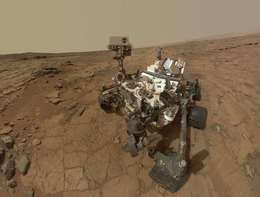
Curiosity, the Mars Science Laboratory rover, resumed operations on Mars resumed operations on March 11th 2015, after an electrical short circuit in the rover’s robot arm caused a suspension of activities while the matter was investigated, and short itself having triggered the rover to switch to a “safe” mode to prevent any potential damage.

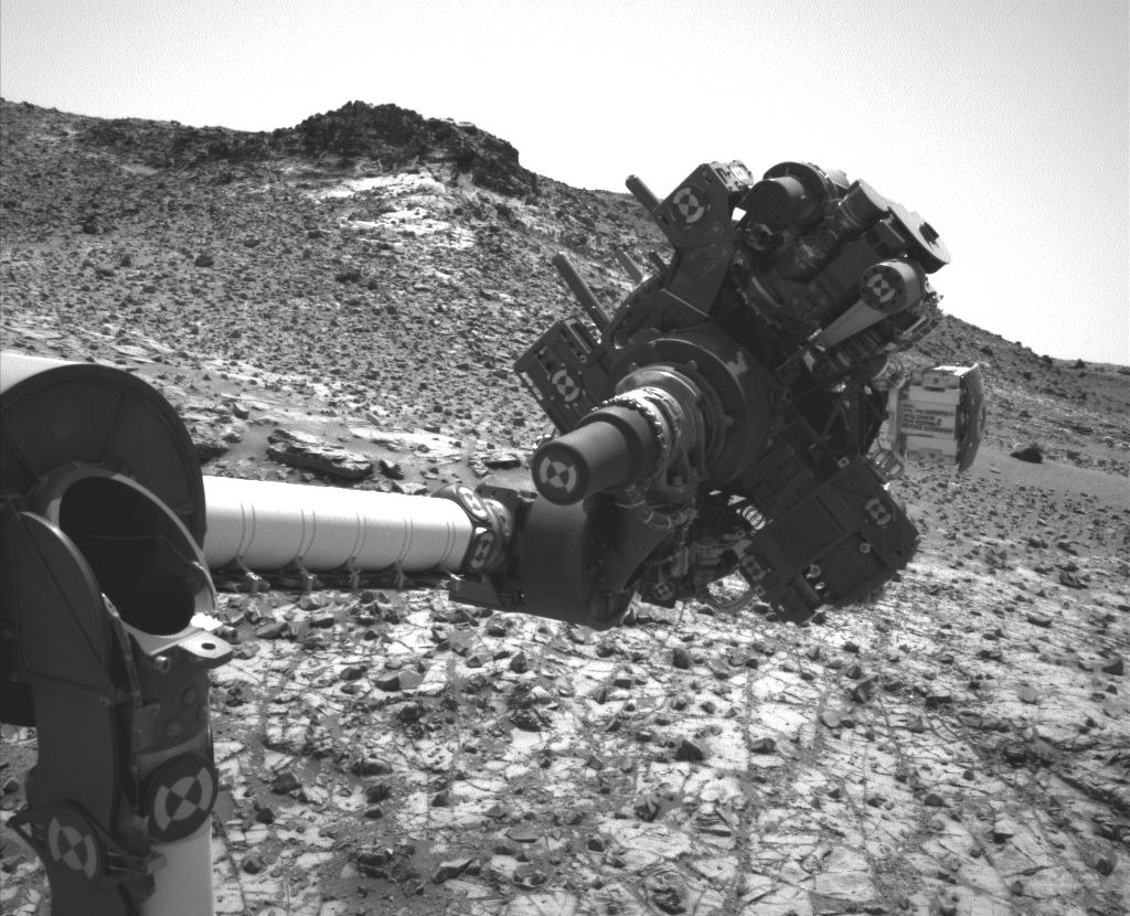
The short, was not enough to damage the rover’s electrical systems in any way, occurred occurred when the was attempting to transfer samples of material gathered from a rock dubbed “Telegraph Peak” from the drill head to the CHIMRA system by subjecting the entire turret to rapid vibrations from the drills percussion action. Extensive tests were carried out over 10 days to try to determine if the short was transient, or indicative of a potential fault. Only one test during this time caused a further short, which lasted around 1/100th of the second, and didn’t interrupt the drill motor.

The results of the tests gave engineers a high degree of confidence that the short wasn’t indicative of the major fault developing, and so operations recommenced on March 11th with the transfer of some of the “Telegraph Peak” material being delivered to the rover’s on-board laboratory while analysis of the results from the tests carried out on the drill mechanism continue to be examined.

Walkabout and onwards drive: an overlay showing Curiosity’s meanderings through the “Pahrump Hills” area at the base of “Mount Sharp” from September 2014 through March 2015. The rover is now proceeding further upwards along the slopes of “Mount Sharp”, and will use the valley dubbed “Artist’s Drive” to reach its next destination

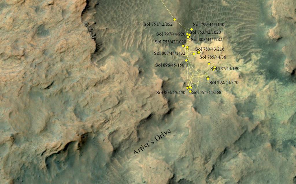
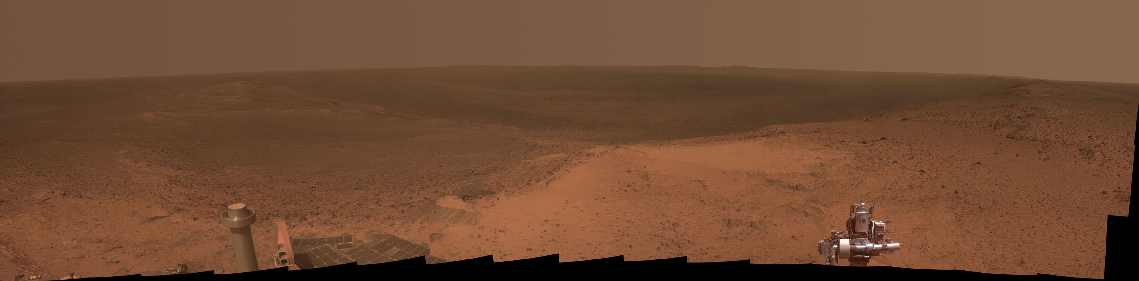
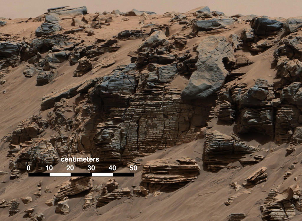
As Curiosity now heads on up the slopes of “Mount Sharp”, aiming to pass through a shallow valley dubbed “Artist’s Drive”, NASA  has confirmed that the rover has found “biologically useful nitrogen” on Mars.

Nitrogen is essential for all known forms of life, since it is used in the building blocks of larger molecules like DNA and RNA, which encode the genetic instructions for life, and proteins, which are used to build structures like hair and nails, and to speed up or regulate chemical reactions. On Earth and Mars, however, atmospheric nitrogen is locked up as nitrogen gas (N2) – two atoms of nitrogen bound together so strongly that they do not react easily with other molecules; they have to become “fixed” (separated) in order to participate in the chemical reactions needed for life.

On Earth, certain organisms are capable of fixing atmospheric nitrogen and this process is critical for metabolic activity. However, smaller amounts of nitrogen can also be fixed by energetic events like lightning strikes.

An updated version of Curiosty's "selfie" from February 2013, when the rover was examining the rock dubbed "John Klein".  The original image rendered a "fishbowl" look; in this revised image, the background has been flatened and rendered as seen from a single point in the camera's field of view, while the view of Curiosity is made up of a number of images captured by the rover's Mars Hand Lens Imager (MAHLI)
An updated version of Curiosity’s “selfie” from February 2013, when the rover was examining the rock dubbed “John Klein”. The original image rendered a “fishbowl” look; in this revised image, the background has been flatenned and rendered as seen from a single point in the camera’s field of view, while the view of Curiosity is made up of a number of images captured by the rover’s Mars Hand Lens Imager (MAHLI) – image: NASA / JPL

While Nitrogen has long been known to exist on Mars, a study by the NASA team supporting the Sample Analysis at Mars (SAM) experiment onboard the rover reveals that NO3, a nitrogen atom bound to three oxygen atoms and a source of “fixed” nuitrogen  has been found in numerous samples gathered by the rover during its journey across Gale Crater.

Although the report’s authors make it clear that there is no evidence to suggest that the fixed nitrogen molecules they’ve discovered were created by life. The confirmation that NO3 does exist adds significant weight to the potential for Mars once having the kind of environment and building blocks needed by life. This is particularly relevant, given that one of the areas in which the NO3 was identified is the “Yellowknife Bay” area, which Curiosity examined in early 2013, and which was shown to have once had a very benign environment for life processes, complete with water, many of the right chemicals, and a local source of energy. This prompted Jennifer Stern of NASA’s Goddard Space Flight Centre in Greenbelt, Maryland, and a co-author f the report to note, “Had life been there, it would have been able to use this nitrogen.”

However, it is more likely that the fixed nitrogen that has been discovered may have been generated primarily by the numerous powerful impacts that occurred about 4 billion years ago, during a period known as the Late Heavy Bombardment, when the inner planets of the solar system were “hoovering up” the remaining debris of asteroids and rock scattered across their orbits.  That said, “fixed” nitrogen has also been detected high in the modern day Martian atmosphere by Europe’s Mars Express.  What’s missing at the moment is the capability to get a big enough nitrate signal for any nitrogen isotope data which might exist, as none of the experiments on Mars are broad enough to do so, thus this is likely to be something future missions to Mars will consider.

Continue reading “Space Sunday: nitrogen nibbles”

Short circuits on Mars and mapping asteroids

CuriosityFollowing my last Curiosity update, which noted that other than for one potential drilling / sampling target, work was wrapping-up for the Mars Science Laboratory in the “Pahrump Hills” location on the lower slopes of “Mount Sharp”, the decision was taken to indeed gather one more sample.

The selected target had been dubbed “Telegraph Peak”, and sits towards the top end of “Pahrump Hills”. It was selected because Alpha Particle X-ray Spectrometer (APXS) measurements carried out by the rover during its 5-month “walkabout” in “Pahrump Hills” revealed the rocks in the area to be relatively enriched in silicon when compared to the corresponding amounts of aluminium and magnesium, which is somewhat different to rocks sample prior to the rover arrival at the basal slops of “Mount Sharp”. This enrichment has also shown to increase the further up the slopes of “Pahrump Hills” the rover climbed, which is of interest to the science team.

“When you graph the ratios of silica to magnesium and silica to aluminium, ‘Telegraph Peak’ is toward the end of the range we’ve seen,” Curiosity co-investigator Doug Ming explains. “It’s what you would expect if there has been some acidic leaching. We want to see what minerals are present where we found this chemistry.”

Sampling took place on February 24th, 2015 (PDT) or Sol 908 for the rover on Mars. For the first time in Curiosity’s time on Mars, it was carried out with no preliminary “mini-drill” operation. Instead, the science team judged that analysis of the rock by APXS indicted it was of a very similar nature to the previous two sample drilling sites in “Pahrump Hills”, and the new lower percussion drilling capabilities the rover now has were judged as sufficiently safe enough to go ahead with a direct sample gathering operation.

How the drill works: On the left, a view of the drill mechanism mounted on the rover's turret, with the drill bit centre bottom. On the right a cutaway showing the sample collection mechanism in the drill bit
How the drill works: On the left, a view of the drill mechanism mounted on the rover’s turret, with the drill bit centre bottom. On the right a cutaway showing the sample collection mechanism in the drill bit

As I’ve covered previously in these pages, obtaining a sample for analysis is a multi-part operation. First the rock is drilled, and a core sample forced up through the drill bit into a one of two sample collection chambers at the top of the drill mechanism. From here, the sample is “shaken” through a feed to another device in the rover’s robot arm turret called CHIMRA – the Collection and Handling for In-Situ Martian Rock Analysis system, used to separate the tailings through a series of sieves, ready for different sizes of sample grains to be passed through the the rover’s on-board laboratory systems.

Both of these operations require the use of the drill’s percussive system to vibrate the turret, forcing material both from the drill’s sample collection chamber and through CHIMRA. However, on February 27th, during the initial operation to move the sample tailings from the drill chamber to CHIMRA, Curiosity’s on-board fault protect system identified a transient short circuit within the robot arm’s electronics. The immediately resulted in all arm-related activities being shut down, and the arm and turret locked into position ready for diagnostic operations to commence.

A transient short can occur for a number of reasons, and can pass without significant problems. However, it may also indicate a potential issue which might require some measure of action, such as a change in operating procedures or a restriction on how a mechanism is used, in order to avoid the issue becoming a serious problem in the future. To this end, following the fault report, mission engineers started diagnosing the problem, with almost all rover operations halted while they did so.

A monochrome image from Curiosity’s Navigation Camera (Navcam) shows the position in which the rover held its arm for several days after a transient short circuit triggered on-board fault-protection programming to halt arm activities on February 27th, 2015 PDT, the 911th Sol of the rover’s work on Mars.

On Thursday, March 5th, as a part of the investigative process, the rover was commanded to carry out a series of vibration tests of the kind performed while forcing the transfer of samples from the drill to CHIMRA. The vibrations were carried out with the robot arm and turret in the same orientation and position which caused the initial triggering of the fault protection system, and in the third of 180 repeat motions, a similar transient short occurred, lasting less than one one-hundredth of a second, enough to trigger the rover’s fault protection systems, and confirming there does appear to be some kind of electrical issue.

Tests are now under-way to determine whether or not the short will occur with the turret in different orientations, and may be followed by additional tests to see if it occurs with the arm in different positions. If no shorting occurs with either a change in the orientation or position of the turret / arm, then the most obvious step in preventing any recurrence of the issue is to avoid placing the turret / arm in the same orientation for sample transfer operations during future drilling activities.

It is hoped that the tests can be completed in the course of the next week. If they show that operations can be resumed safely, it is anticipated that the sample transfer operations will be completed, and Curiosity will then be ready to resume its climb up “Mount Sharp”, leaving “Pahrump Hills” via a narrow valley the science team have dubbed “Artist’s Drive”.

Continue reading “Short circuits on Mars and mapping asteroids”

Avatars on Mars, Falcons in Florida and oceans in space

CuriosityCuriosity, NASA’s Mars Science Laboratory (MSL), has been wrapping things up in the “Pahrump Hills” region at the base of “Mount Sharp”, the mountain-sized mound of deposited material occupying the centre of Gale Crater.

For the last several months, the rover has been engaged on what geologists on Earth call a “walkabout”, zigzagging back and forth across the area, looking for targets of interest for follow-up investigations, and allow the science team to better understand the geology and form of the region.

This method of activity is a change from how Curiosity has largely operated to date, which has seen the rover primarily move from point-to-point along its route, only re-visiting sites as a part of its onward movement towards the goal of reaching and climbing “Mount Sharp” (such as when travelling into, and then back out of the “Glenelg” and “Yellowknife Bay” regions Curiosity first explored in 2012 / 2013).

Curiosity's wandering through
Curiosity’s wandering through “Pahrump Hills”, which started with one of the tree lines into the region at the top of the image

In this respect, and as Aileen Yingst, the Deputy Principal Investigator with the Mars Hand Lens Imager (MAHLI) on the rover, describes, Curiosity has been demonstrating just how much of an avatar it is for the science team, allowing them to careful investigate, examine and catalogue “Pahrump Hills” in a rich, practical way using the very human technique of the “walkabout”, which will serve the mission well as the ascent up “Mount Sharp” continues.

Most recently, and since collecting samples from “Mojave 2″, the area of rock displaying interesting crystalline elements within it, Curiosity has been looking at an area geologists dubbed “pink cliffs”, which shows further signs of the crystalline structures, and might be a candidate for further investigation. If so, it will be the last stopping point in “Pahrump Hills” before Curiosity continues its climb up “Mount Sharp”.

Oppy Reaches 11

January 25th, 2015 saw NASA’s Mars Exploration Rover, Opportunity, reach it’s eleventh anniversary on Mars. The rover, one of two MER vehicles, arrived on Mars at January 25th, 2004 (Universal Time), ready to start a mission initially planned to last just 90 days.

Since then, and up to its anniversary, “Oppy” has travelled a distance of some 41.7 kilometres (25.9 miles). While this doesn’t sound that much (and in truth, a human science team could have travelled that far in just a few days, including time for any science carried out along the way), remember that “Oppy’s” forward speed is measured in centimetres per hour.

As one of two solar-powered MER rovers (the second, Spirit having finally succumbed to the hostile environment on Mars around March 215th, 2011), Opportunity has carried out an incredible amount of work, and greatly contributed to our understanding of the planet, returning compelling evidence about wet environments on ancient Mars.

A panoramic view of Endeavour Crater as seen from “Cape Tribulation” an uprising close to the crater’s rim, the summit of which Opportunity reach in January 2015, marking its 11th anniversary on Mars (click for full size)

The rover marked its anniversary by reaching the summit of “Cape Tribulation”, an uprising close to the rim of 20 kilometre (13.7 mile) wide Endeavour Crater, which the rover has been gradually circumnavigating. This involved a change in elevation for “Oppy” of about 135 metres (440 feet), and afforded it a panoramic view of the crater and the land around it, presenting a unique opportunity for geological observations of the crater and its rim.

 A New Mars Mystery

That night, too, there was another jetting out of gas from the distant planet. I saw it … That night another invisible missile started on its way to the earth from Mars, just a second or so under twenty-four hours after the first one.

– The narrator, H.G. Wells’ The War of the Worlds

Okay, so it’s unlikely to be the sign of an impending invasion of Martians possibly ticked-of at the way we’re cluttering-up their planet with our probes and landers and rovers, but recent events high in the atmosphere of Mars have given rise to some excitement.

The images, originally capture in 2012, show huge plumes rising some 250 kilometres (156 miles) into the most tenuous reaches of Mars’ thin atmosphere.

Martian high-altitude plumes
Martian high-altitude plumes (image: ESA)

The plumes occurred on two separate occasions in March and April 2012, and were spotted by amateur astronomers. Each time, they developed with relative rapidity, rising upwards and outwards to cover areas of some 1000 x 500 kilometres (625 x 312.5 miles) in a period of around 10 hours before remaining visible for up to 10 days at a time, their structure and form changing on a daily basis.

Unfortunately, neither event was seen from orbit about Mars, occurring so high on the planet’s limb as to be effectively out-of-sight for the NASA and ESA orbital vehicles, and by the time word had spread sufficiently about the observations, the events were largely over.

However, investigations into images of the planet taken by the Hubble Space Telescope in orbit around the Earth have revealed similar plumes being imaged in the past. However, with the exception of an image captured in 1997, none have been anywhere near as high or dramatic as the 2012 events.

So what might have caused this plumes to occur? The answer to that question is uncertain.

Continue reading “Avatars on Mars, Falcons in Florida and oceans in space”

“I spy with my big eye…” and landing a rocket on Earth

CuriosityNASA’s Curiosity rover has been a busy bunny on Mars. Currently still parked in the “Pahrump Hills” terrain on the lower slopes of “Mount Sharp”, the Mars Science Laboratory (MSL) rover has now completed its latest drilling activity, collecting samples from a rock dubbed “Mojave 2”.

This isn’t actually the rock from which the science team had originally hoped to gather samples. That rock, dubbed “Mojave” broke apart as a result of the percussive action of the rover’s drill during a “mini-drill” test. As a result, the rock was ruled out as a sample gathering target. “Mojave” was of particularly interest to scientists as Curiosity had images tiny, rice-grain sized crystalline minerals that might have resulted from evaporation of a drying lake, thus presenting the science team with a further insight into environmental conditions within Gale Crater.

To counter this loss, the team relocated Curiosity to  “Mojave 2”, another rock within the same outcrop as “Mojave”, and which exhibits similar crystalline features. In doing so, the team were able to bring into play software improvements only recently uploaded to the rover as a part of an overall systems upgrade, which was deployed to one of the rover’s two computer systems at the end of January.

The software improvements for the drill are the result of investigations into the fracturing of a rock during a previous attempt to obtain samples prior to the rover arriving on “Mount Sharp”. Like an Earth-based hammer drill, the rover’s drill uses a percussive action, so that as well as drilling into a rock, the drill bit effectively hammers its way into the rock. In all, there are six settings governing the amount of percussive energy used during drilling, which range from a gentle tapping (level 1) through to hammering at the rate of 30 times a second with a 20-fold increase in energy imparted (level 6).

During early drilling operations the software monitoring these percussion settings “learned” that defaulting to the “level 4” setting best met the needs of gathering samples in the harder rock types the rover initially encountered. However, this was proving too forceful for the softer rocks closer to, and on, “Mount Sharp”, but the software was unable to switch down to a lower setting.

The drill hopes on "Mojave 2" captured by Curiosity's Mastcam. Towards the top is the small, "mini drilling" test bore, just a couple of centimetres deep, created on Sol 881 (January 28th, 2015, PDT) and some 10 centimetres below it, the sample-gathering bore hole, some 6.5 centimetres deep, cut on Sol 882 (January 29th, 2015, PDT).
The drill holes on “Mojave 2” captured by Curiosity’s Mastcam. Towards the top is the small, “mini drilling” test bore, just a couple of centimetres deep, created on Sol 881 (January 28th, 2015, PDT) and some 10 centimetres below it, the sample-gathering bore hole, some 6.5 centimetres deep, cut on Sol 882 (January 29th, 2015, PDT).

The new update causes the drill software to reset to “level 1” after each drilling operation, and then step through the levels incrementally until the ideal is found. As a result, a sample was gathered from “Mojave 2” without the drill needing to step beyond the “level 2” percussion action.

Drilling operations on “Mojave 2” took place on Sol 881 and Sol 882 (January 28th and 29th, PDT, respectively). As per standard operating procedure, the first drilling operation was a test “mini drilling” to see how the rock responded to encroachment and cutting. The second, which took the dill to a depth of around 6.5 centimetres (2.6 inches). The gathered samples were then sifted and sorted through the CHIMRA system in the rover’s turret, prior to being transferred via the surface scoop to Curiosity’s primary laboratory systems, ChemMin and SAM.

At the same time as Curiosity was carrying out its initial analysis of the “Mojave 2” rock, NASA released an image captured by the HiRise (High Resolution Imaging Science Experiment) carried aboard the orbiting Mars Reconnaissance Orbiter (MRO), which forms the mainstay of the rover’s communications with Earth. The image, which was taken on December 13th, 2014, reveals Curiosity mid-way through its “walkabouts” in “Pahrump Hills”, when it was seeking potential targets of interest for further study.

While not the first time the rover has been imaged from orbit, this is one of the clearest pictures from the rover yet capture from an altitude of around 280 kilometres (175 miles) above the surface of Mars.

"I see you!" - MRO's HiRise image of the curiosity rover, obtained on December 13th, 2014, as the rover explores the "Pahrump Hills" region on a basal slopes of "Mount Sharp"
“I see you!” – MRO’s HiRise image of the curiosity rover, obtained on December 13th, 2014, as the rover explores the “Pahrump Hills” region on a basal slopes of “Mount Sharp”

Initial results from ChemMin (the Chemical and Mineralogy) instrumental has shown that the rock was likely effected by water that was much more acidic in nature than evidenced through the analysis of other rock samples obtained by the rover. The still-partial analysis shows a significant amount of jarosite, an oxidized mineral containing iron and sulphur that forms in acidic environments. This raises the question of whether the more acidic water was part of environmental conditions when sediments were being deposited to form “Mount Sharp”, or the result of fluids soaking the rocks at a later time.

ChemMin was also unable to identify a clear candidate mineral for the crystalline deposits which first attracted the science team to the outcrop; this presents the possibility that the minerals responsible for originally forming the crystals may have been leached away over time and replaced by other minerals during later periods of wet environmental conditions.

It is hoped that SAM – the Sample Analysis at Mars – suite of instruments may be able to reveal more about the nature and composition of the samples once they have completed their round of analysis. Depending on the outcome of this work, Curiosity may be ordered to gather a further rock sample from “Pahrump Hills”, or may be ordered to continue upwards and into new territory on “Mount Sharp”.

Continue reading ““I spy with my big eye…” and landing a rocket on Earth”

All change, getting virtual on Mars and watching the asteroid go by

CuriosityThe start of the year has brought – and is bringing – some changes to the Mars Science Laboratory mission. The first change has occurred here on Earth. On January 5th, 2015, John Grotzinger from the California Institute of Technology stepped down as the mission’s principal Project Scientist in overall charge of a team of some 500 people from across the globe who are operating the rover and its suite of scientific instruments.

Recently promoted to chair Caltech’s Division of Geological and Planetary Sciences, Grotzinger will still be involved in the mission, but his new responsibilities mean he cannot reasonably continue in such a lead role within the project. Stepping into his shoes, therefore, is Ashwin Vasavada of NASA’s Jet Propulsion Laboratory. He has been serving in the role of Deputy Project Scientist since the mission’s inception 2004, and has been intimately involved in both the development of the mission’s science packages and the rover itself. As such, he is ideally placed to take over from Grotzinger.

“John Grotzinger put his heart and soul into Curiosity for seven years, leaving a legacy of success and scientific achievement,” he said on taking over the role. “Now I look forward to continuing our expedition to Mars’ ancient past, with a healthy rover and a dedicated and passionate international team. And yes, this is all just incredibly cool.”

Ashwin Vasavada of NASA’s Jet Propulsion Laboratory, Pasadena, California, took over has the MSL’s Project Scientist from John Grotzinger at the start of January, 2015

Meanwhile, on Mars, Curiosity is engaged in further studies of rocks within the “Pahrump Hills” area on the lower slopes of “Mount Sharp”. These studies will involve drilling for rock samples from at least one more target of interest,  prior to the rover continuing its climb up the flank of the mountain.

The initial target for sample gathering has been dubbed “Mojave”, which appears to be rich in crystalline minerals. Slightly smaller than grains of rice, the structures first appeared on early images of the rock captured by the rover, and have caused intense – no pun intended – curiosity among mission scientists.

“We don’t know what they represent,” Vasavada said of the mineral forms and the decision to target “Mojave” for drilling. “We’re hoping that mineral identifications we get from the rover’s laboratory will shed more light than we got from just the images and bulk chemistry.”

Prior to drilling for actual samples, Curiosity was first ordered to carry out a “mini drilling” operation. This is a routine test to ascertain a number of things prior to committing to a full-on sample gathering exercise. These include making sure the rock is stable enough for a full drilling operation, gathering data of the reaction of the drill to penetrating the rock surface, ensuring any drilling operation will not cause undue vibration within the rover’s mechanisms, and so on.

A unique view of the "mini drilling" operation on "Mojave". Captured by Curiosity's Hazcam navigation cameras, the image shows the rover's "hand" oriented such that the dril (visible with its two steadying arms) is placed against the rock
A unique view of the “mini drilling” operation on “Mojave”. Captured by Curiosity’s Hazcam navigation cameras, the image shows the rover’s “hand” oriented such that the drill (visible with its two steadying arms) is placed against the rock, with the peak of “Mount Sharp” forming a backdrop.

The initial mini-drilling operation took place on January 13th 2015, during the 867th Martian day, or Sol, of Curiosity’s work on Mars. It marks the third phase of science operations in the “Pahrump Hills” area, having been preceded by a “walkabout” of the area in which potential target sites for detail investigation were noted prior to follow-up examinations of several of them using some of the rover’s on-board systems, such as the Alpha Particle X-Ray Spectrometer and the Mars Hand Lens Imager (MAHLI), both of which are also mounted on the “hand” or turret at the end of the rover’s robot arm.

Once samples from “Mojave” have been collected, they’ll be passed through the CHIMRA system inside the turret, which will prepare them for delivery to the rover’s main on-board science suits, SAM and ChemMin. The latter (standing for Chemistry and Mineralogy instrument), will hopefully reveal a lot more about the chemical composition of the crystals. Additionally the drilling operation itself should reveal whether the crystals are only at the surface, like a salty crust, or are also deeper in the rock, which itself might lead to clues about their origins

“There could be a fairly involved story here,” Vasavada said. “Are they salt crystals left from a drying lake? Or are they more pervasive through the rock, formed by fluids moving through the rock? In either case, a later fluid may have removed or replaced the original minerals with something else.”

Two other potential targets for drilling operations are also under consideration before the rover moves out of the “Pahrump Hills” area.

The view is a mosaic of four focus-merge images created by Curiosity from 40 images acquired using MAHLI on Sol 809 (November 15th, 2014 PDT). It shows an area of the “Mojave” rock which has been cleaned by the rover’s dust removal tool in order to reveal the tiny rice-like crystalline deposits. The penny in the lower left is to scale with the mosaic

Continue reading “All change, getting virtual on Mars and watching the asteroid go by”

Of mountains, methane and molecules

CuriosityAfter what has been a relatively quiet period in terms of news from Mars, things are once again proving interesting.

The first uptick came following the start-of-month teleconference Mars Science Laboratory personnel held to summarise the results of the last several months of activities the Curiosity rover has been performing in Gale Crater. In particular, these have allowed scientists to better determine how the 5 kilometre high mound at the centre of the crater may have been formed.

Even before Curiosity arrived on Mars, sufficient evidence had been obtained from orbit to show that features in and round Gale Crater were likely influenced by water-related activity. Curiosity itself found evidence for water once having flowed freely across parts of the crater when it encountered the beds of ancient rivers and streams as it explored the regions dubbed “Glenelg” and “Yellowknife Bay”.

With the journey down to “Mount Sharp”, and NASA call the mound, and the recent explorations of its lower slopes, the science team have been able to piece together the processes that led to its formation.

The first clues came while Curiosity was still en route to the point where examination of the “Mount Sharp’s” lower slopes could begin. As it drove southwards and towards the mound, the rover started to encounter layered sandstone deltas, all inclined towards “Mount Sharp”. On Earth, such layered, angled deposits are found where a river flows into a large lake.

A mosaic of images captured by Curiosity’s Mastcam on March 13, 2014 PDT (Sol 569). White-balanced for natural Earth light, the images show layered sandstone deposits, all pointing towards “Mount Sharp”, indicative of delta sediments dropped by a flowing river as it enters a large lake

Once in the foothills of “Mount Sharp”, in the area dubbed “Pahrump Hills”, Curiosity has repeatedly come across layers of tightly-compacted sedimentary mudstone which are entirely consistent with the sedimentary layering found in the muds and rock in lake beds on Earth. Intriguingly, while most of these layers appear to have been formed by sediments settling out of a large, still body of water, some of them appear to have been affected by wind erosion.

This latter point would indicate that rather than the crater floor once being covered by a single body of water which gradually vanished over time, it was subjected to cycles of wet and dry periods, giving rise to a number of lakes forming within the crater over the ages, each one only a few metres deep. As the water receded / vanished during the dry periods, so the uppermost layers of each lake bed were exposed to the wind, eroding them, before the next wet period started, and a new lake formed, gradually depositing more sediments on top of them.

Thus over a period of millions of years, Gale Crater was home to numerous lakes, each of them fed by assorted rivers and streams flowing into them, giving rise to the alluvial plains around the base of the crater walls, and the sedimentary deltas closer to “Mount Sharp” where these rivers and streams met the standing waters of each lake.

This diagram depicts a vertical cross section through geological layers deposited by rivers, deltas and lakes. A delta builds where a river enters a body of still water, such as a lake, and the current decelerates abruptly so sediment delivered by the river settles to the floor.

This view of Gale Crater is further supported by measurements of the deuterium-to-hydrogen ratio in the rocks sampled by Curiosity. These suggest that the sediments the rover is now examining were laid down during a period when Mars had already started losing its surface water, suggesting an extended period of climatic change on the planet, where the amount of free-standing water may well have been in flux.

Once the water had completely vanished from Gale Crater, it seems likely that “Mount Sharp” was sculpted by wind action within the crater. Thus, it is thought, would have eroded the material of the alluvial plains faster than the more densely compacted mudstone formed under the weight of the successive lakes.

As it might have been: the left image shows the repeated depositing of alluvial and wind-blown matter (light brown) around a series of central lakes which formed in Gale Crater, where material was deposited by water and more heavily compressed due the weight of successive lakes (dark brown). Right: once the water had fully receded / vanished from the crater, wind action took hold, eroding the original alluvial / windblown deposits around the “dry” perimeter of the crater more rapidly than the densely compacted mudstone layers of the successive lake beds, thus forming “Mount Sharp”

Continue reading “Of mountains, methane and molecules”