Operations on and around Mars are resuming following the June 2015 conjunction, which saw Mars and Earth on opposite sides of the Sun, a time which makes reliable two-way communications hard-to-impossible due to the Sun’s interference, so vehicles operating on and around the Red Planet are placed in autonomous modes of relatively safe operations.
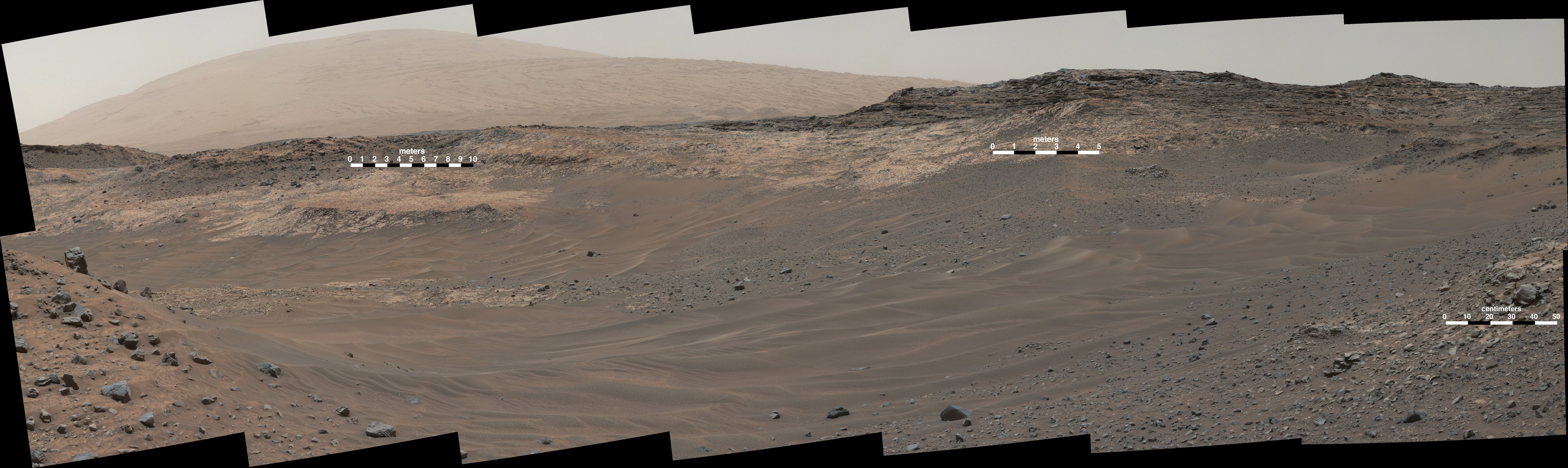
For the NASA rovers, Opportunity and Curiosity, this meant parking and waiting for reliable communications to be restored. However, now that Mars has once again emerged from “behind” the Sun, Curiosity is preparing to study the confluence of at least two different types of rock formation on the slopes of “Mount Sharp”.
As noted in my recent Curiosity updates, the Mars Science Laboratory (MSL) had been attempting to reach such a confluence, dubbed “Logan Pass”, but the terrain leading to that location proved more difficult from had been hoped. As a result, the rover was redirected towards another point leading up to higher elevations dubbed “Marias Pass”, and a small valley where the rock formations meet.

The two types of rock are a pale mudstone, similar in appearance to the bedrock studied at “Pahump Hills”; the other is a darker, finely bedded sandstone sitting above the Pahrump-like mudstone, which has been dubbed the “Stimson unit”. In addition, the valley also has a sandstone with grains of differing shapes and colour which the science team wish to examine in more detail as well, having already identified a potential target within it they’ve named “Big Arm”.
“On Mars as on Earth, each layer of a sedimentary rock tells a story about the environment in which it was formed and modified,” NASA spokesman Guy Webster said during a status update on the mission which explained the science team’s interest in the area. “Contacts between adjacent layers hold particular interest as sites where changes in environmental conditions may be studied. Some contacts show smooth transitions; others are abrupt.”
Curiosity is expected to spend the next few weeks examining the rock formations before resuming its trek up the side of “Mount Sharp”.
Dawn Over Ceres

On Monday, June 30th, The joint ESA / NASA Dawn deep space mission completed the second of its orbital mapping phases of Ceres, which it has been carrying out since May at a distance of some 4,400 kilometres (2,700 miles).
During July, the spacecraft will engage in a series of gentle manoeuvres that will allow it to reduce its orbit to 1,450 kilometres (900 miles), ready to start a further surface mapping and investigation mission in early August.
Ceres has revealed it has a much more varied landscape that Vesta, its slightly smaller “sister” protoplanet, which the Dawn spacecraft studied over a prior if 14 months in 2011/12, prior to reaching Ceres in March 2015. One particular point of interest on the latter is a grouping of bright surface features located within a crater some 90 kilometres (55 miles) across.
The most recent images returned be Dawn of these spots reveals they are more numerous than had first been thought, with the largest approximately 9 km (6 miles) across. It is believed these bright spots are the result of ice or salt, although other causes may be possible; spectra of the region should reveal far more as the spacecraft reduces its orbit.

In addition to the bright spots, the latest images also show a pyramid-like mountain with steep slopes rising to a height of about 5 km (3 miles) from a relatively flat area on Ceres, which has also provoked scientific interest. Ceres is also richly cratered, like Vesta; however, unlike Vesta, many more of the craters on Ceres have central peaks associated with them, evidence of their formation being the result of surface impacts. Images have also revealed evidence of other activities on the rocky, barren surface: slumps, landslides and lava-like flows, all indicative of Ceres perhaps having been somewhat more active in its formative years than Vesta.
Continue reading “Space Sunday: Mars rocks, Ceres glitters, Pluto beckons”