SpaceX Look to Resume Falcon Flights in November 2016
SpaceX President Gwynne Shotwell has indicated the company hopes to resume Falcon 9 launches from November 2016, despite the September 1st loss of the launch vehicle and its US $200 million Amos 6 Israeli-built communications satellite during the preparations for a full static fire test of the rocket’s main engines.
It’s an ambitious aim, given that the cause of the loss is still unknown – and until it is known, it is highly unlikely the Falcon 9 will be cleared for flight by the FAA. However, the comments might suggest company feel that the cause of the loss may not have been with the booster itself, but may have been triggered by an external event, in which case such a target might be possible.

The static fire test is a part of pre-launch preparations unique to SpaceX. Basically a full dress rehearsal of a launch, it includes fuelling the booster and briefly firing the main engines with the rocket locked-down on the pad. It was during fuelling operations, eight minutes before the rocket motors were to be fired, the that a series of explosion occurred, destroying the booster and its payload.
Video footage seems to suggest the point of origin for the explosions was outside of the vehicle, in what SpaceX has called a “fast fire”, which started at, or near, the liquid oxygen fuelling umbilical. As well as the complete loss of the vehicle, the explosions and fireball caused extensive damage to Space Launch Complex (SLC) 40 at Canaveral Air Force Station, which had been leased to SpaceX for Falcon 9 launches.
It is the second lost of a Falcon 9 rocket in 15 months. In June 2015, the vehicle carrying the Dragon CRS-7 cargo resupply vehicle to the International Space Station disintegrated a little over two minutes after lift-off, following the failure of an internal strut.
In order to resume launches and meet obligations, SpaceX are planning on pivoting Falcon 9 launches to Kennedy Space Centre’s Pad 39A until such time as SLC 40 can be repaired. SpaceX leased the pad – a part of the complex used to launch the Saturn IB, Saturn V and space shuttles – in 2014 in a 20-year deal. It is currently being refurbished at the company’s expense to launch crewed Dragon 2 flights to the International Space Station, and commercial missions using their new Falcon Heavy launcher. Currently, there is still much work to be completed at the launch complex – previously used to launch the space shuttle, and before that, the mighty Saturn V rocket, although SpaceX plan to have the work completed by November.

Whether or not the root cause of the September 1st accident will be known by then, and the Falcon 9 cleared for flight is a major unknown. The investigations into the June 2015 loss took six months to complete and – due to it being caused by a failure within the vehicle – the rocket had to undergo several engineering changes.
Blue Origin Announces the New Glenn Booster Family
Blue Origin, the company founded by Amazon founder Jeff Bezos, revealed its plans for a family of reusable boosters for both orbital and deep space launches. Called New Glenn, the vehicles are a significant step forward for the company.

Although more widely known for their efforts in the sub-orbital space tourism field, with their New Shephard reusable system, Blue Origin has long indicated it has wider aspirations, whilst remaining somewhat tight-lipped about exactly what it is developing.
Like the smaller New Shephard sub-orbital launch vehicle, New Glenn is to comprise a reusable first stage – referred to as the “propulsion module” on New Shepard. The vehicle has been under development for about 4 years, and the plan is for the first launch to take place in 2020.
Seven metres (23ft) in diameter, the New Glenn first stage will be powered by seven of the company’s new BE-4 engines. These are the same engines United Launch Alliance have selected as the primary propulsion unit for their own upcoming new Vulcan launch vehicle, which will enter service in 2019 to replace the expensive Atlas V booster.
This core stage of the new Blue Origin rocket – which is named for John Glenn, the first American to orbit the Earth, just as New Shephard is named after Alan Shephard, the country’s first astronaut to fly in space – will be topped by either a second stage for launches to low-Earth orbit, or a combination of a second stage and third stage system capable of a broader range of launch options. In both variants, the second stage will be powered by a single BE-4 engine, while the third stage will be powered by an uprated version of the BE-3 engine, currently used by the New Shephard. Neither the second nor third stages will be recoverable. It is anticipated that New Glenn will be capable of lifting between 35 to 70 tonnes to low Earth orbit, placing it in the same class of launch vehicle as SpaceX’s Falcon Heavy – and thus competing directly with it.
When it enters service, the new booster will be launched from America’s Space Coast, from the historic Space Launch Complex 36 at Canaveral Air Force Station, which Blue Origin took over in September 2015 in a deal with the USAF’s 45th Space Wing.

In its time, SLC 36 was was used to launch the Mariner missions, the first US interplanetary probes to visit over worlds, Pioneer 10 and Surveyor-1, the first US vehicle to soft-land on the Moon. It was largely demolished in 2010, leaving just a single pad. Blue Origin are expected to construct a rocket fabrication and assembly facility there, as well as a new launch complex. Currently, it is not clear how the first stage of the booster will be recovered, but the company have hinted at an automated at-sea landing in the style of SpaceX might be used.
China Launches Tiangong-2
On Thursday, September 15th, 2016, and as expected, China launched the Tiangong-2 (“Heavenly Palace 2”) orbital laboratory from their Jiuquan Satellite Launch Centre in Gansu Province, and on the edge of the Gobi Desert in northern China. The Long March 2F booster (and not a long March 7, as incorrectly reported in some space news outlets) lifted-off at 14:04 UTC, making for a night launch, local time.

Tiangong-2 is the second phase of China’s goal to establish a permanently crewed space station in the early to mid 2020s. This work started in 2011 with the launch of the Tiangong-1 facility, which was briefly visited by two crews in 2012 and 2013. It will culminate in the on-orbit construction of a large space station, starting with the launch of the Tianhe (“Harmony of the Heavens”, and formerly Tiangong-3) space station core module in 2022.

It is expected that at least two crews will visit the facility. The first 2-person crew will fly to the laboratory in October aboard Shenzhou-11. They will commence the first round of a fairly extensive science programme, remaining at the lab for around 30 days.
After this, the facility will be left dormant until April 2017, when a Long March 7 booster is due to deliver the Tianzhou (“Heavenly Ship”) uncrewed resupply vehicle to orbit. This craft will then perform an automated docking with Tiangong-2, providing it with additional fuel, water and other consumables and also use its engine to boost the laboratory into a higher orbit to await the arrival of the second crew.
The second crew, comprising 3 personnel, should fly to the facility in mid-2017 Shenzhou-12. They are expected to say for less than 30 days, but while there carry out a number of tasks connected to developing a full space station, including performing an EVA. Whether further crews will visit the station after this has yet to be determined.
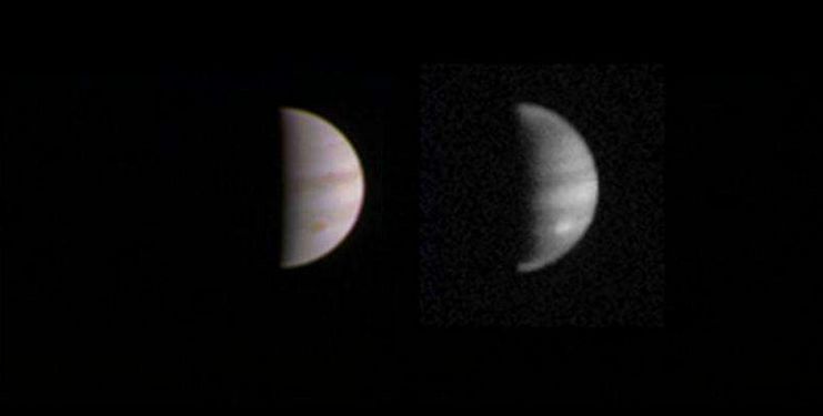
A Billion Stars – A Map to Our Galactic Neighbourhood

The above image might not look like much, but it is the largest all-sky survey of celestial objects published to date, pinning down the precise position on the sky and the brightness of 1142 million stars in our galaxy.
It is the product of the European Space Agency’s (ESA) Gaia Project, which is approaching the mid-point in its 5-year mission. Launched in December 2013, and orbiting the L2 Lagrange point, Gaia commenced its mapping operation in July 2014 – and it will continue doing so through until 2017. This map, released by the European Space Agency on September 14th, covers the data gathered from July 2014 through to September 2015. A further map, which includes data through to August 2016, is currently in development.

The intention is to create a precise three-dimensional map of astronomical objects throughout the Milky Way, mapping their motions, which reflect the origin and subsequent evolution of the galaxy. Spectrophotometric measurements by the craft will provide a detailed survey of all observed stars, characterising their luminosity, effective temperature, gravity and elemental composition. The data gathered will provide the basic observational data to tackle a wide range of important questions related to the origin, structure, and evolutionary history of our galaxy.
It is the second such survey to be undertaken. The first was ESA’s Hipparcos mission, almost two decades ago, which surveyed around 200 million stars. One aspect of the Gaia survey will be to compare its findings with those of Hipparcos, so it will hopefully be possible to start disentangling the effects of “parallax”, a small motion in the apparent position of a star caused by Earth’s yearly revolution around the Sun, and the “proper motion” of the star’s physical movement through the galaxy.

The Gaia map means it is now possible to measure the distances and motions of stars in about 400 clusters up to 4,800 light-years away, and includes 3194 variable stars, which rhythmically swell and shrink in size, leading to periodic brightness changes. Many of these are located in the Large Magellanic Cloud, one of our galactic neighbours, a region that was scanned repeatedly during the first month of observations, allowing accurate measurement of their changing brightness. During the first phase of the mission, Gaia also discovered its first supernova in another galaxy, and the science and engineering team had to overcome a “stray light” issue where fibres used in the vehicle’s sun shield protrude beyond the edges of the shield and into the field of view. In doing so, they reflect unwanted light, resulting a degradation in science performance when mapping the faintest of stars in Gaia‘s view.
The Birth of a Black Hole?
Black holes; the boogie-men of the cosmos. Deep wells of gravity so intense that not even light can directly escape after passing the event horizon. They are formed in one of two ways, during the death of super-massive stars.
In the first, the star gobbles up the last of its fusionable fuel, causing the core to suddenly and violently contract, in turn triggering a violent explosion – a supernova – completely shedding the star’s outer shell of mass, and leaving behind a super-dense neutron star. Generally only 10 or so kilometres across, this have a greater mass than our Sun. It is thought that if this mass is too great, the neutron star also collapses in on itself, forming a black hole. In the second, the star doesn’t go supernova, but experiences a “failed supernova” brightening for a very brief period as some matter is lost, but then continuing to collapse in on itself until a black hole is formed. In both cases, the star vanishes from the visible spectrum, leaving behind tell-tale signs in the infra-red and in x-rays.

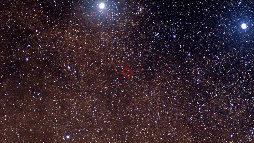
A team of astronomers now believe they have captured the birth of a black hole through this second process.
They were studying data relating to N6946-BH1, a red giant thought to be coming to the end of its life, when they noticed something odd. In 2009 the star, roughly 25 times bigger than our Sun and 20 million light years away, could be seen in the visible light wavelengths. By 2015, however, it had vanished, leaving only an infra-red afterglow. A subsequent check on Hubble Space Telescope data revealed the same: in 2007 the star was visible, in 2015, it wasn’t.
Intrigued, the team checked data on the star from the Palomar Transit Factory (PTF). This revealed that in 2009, N6946-BH1 blossomed briefly in luminosity, with a massive burst of neutrinos occurring at the same time – events both consistent with the star collapsing, but not going supernova. Add these to the infra-red tell-tale, and it would seem N6946-BH1 might have formed a black hole.
If so, it should now be a source of x-rays emitted in a particular spectrum as local matter fails into it. The team are now hoping that the Chandra X-ray Observatory in Earth orbit will be able to take a look at N6946-BH1 in the next two months or so to see if those x-rays can be detected. Should it be determined that N6946-BH1 has collapsed into a black Hole – even one now 20 million years old – studying it could help describe the beginning of the life cycle of a black hole, and better inform us on how black holes form, potentially why some super-massive stars form a neutron star rather than collapsing all the way to a black hole.