Mars as seen from 80 million km (50 million mi): a Hubble Space Telescope image of Mars captured during opposition on May 12th, 2016. Coincidentally, the Arabia Terra, one of the subjects in the report below, is the dark area in the centre of the image, together with Xanthe Terra. Cryse Planitia (Plain of Gold) is in the lower part of the light-coloured circular area dipping into the dark mass of Arabia and Xanthe Terra. North is to the top of the image, south to the bottom. Credit: NASA / ESA
It has long been believed that Mars once had oceans which covered most of the northern hemisphere lowlands about 3.4 billion years ago. Radar mapping from orbit has revealed layers of water-borne sediment similar to those found on Earth’s ocean floors, sitting on top of a layer of volcanic rock. In addition, there is strong evidence for an ancient shoreline and coastal areas around the rim of the ocean. The problem is, the evidence for the coastal areas is far from complete, leading to one of Mars’ many mysteries: if the lowlands were once home to a vast ocean, where did the shoreline go?
Alexis Rodriguez of the Planetary Science Institute in Tucson Arizona believes a study she and her colleagues have been carrying out may hold the key: sections of the Martian coastline may have been washed away as a result of massive tsunamis. And when I say huge – I mean waves towering some 120 metres (400ft) into the air.
The northern hemisphere of Mars when it was once home to an world-circling ocean, 3.4 billion years ago
The time of the Martian ocean coincides when the end of the period known as the Late Heavy Bombardment, when the planets of the inner solar system were subject to a disproportionately large number of asteroid impacts. Rodriguez and her colleagues have suggested that two particularly large meteoroids smashed into the northern hemisphere during this period, driving the tsunamis and reshaping the ancient shoreline.
The focus of the study is a region on Mars where the Arabia Terra upland region meets the lower-lying Chryse Planitia, and which should form a part of the ancient shoreline. Within it, Rodriguez and her team have identified two separate geological formations which may have been created by two separate tsunami events.
This set of images show the region where Arabia Terra flows down to Chryse Planitia. In figure A, the red line denotes the original ancient shoreline of the region. The grey area below and to the left of it denotes depositions believed to be the result of the first tsunami, together with outflow channels carved by the receding flood (blue arrows). The black line indicates the much younger shoreline of the region at the time of the second impact, which saw the formation of icy lobes in the region, and the embaying of features by slurry and material deposit by the receding waters. Images B and C focus on the coastal areas of deposition and embayment. Image created by Esri’s ArcGIS® 10.3 software
The older of the two looks every bit like a coastal region struck by a huge wave which deposited boulders over 10 metres across. As the water then receded back into the ocean, it cut large backwash channels through its debris and boulder field, depositing large amounts of surface material back into the ocean. Then, several million years later, the second impact took place.
This later event came at a time when Mars was effectively entering an ice age, and caused not so much massive tidal waves, but huge ice slurries which spread across the landscape, much of it freezing out, forming lobes of ice. The material which did make it back into the ocean also “embayed” older features there, partially burying them in the slurry.
Radar imaging has revealed subsurface large lobes of icy deposits along the outwash plains and channels in the Arabia Teraa / Chryse Planitia abutment, indicative of the study’s suggestion that some of the material deposited after the second tsunami event froze out before it could flow back to the ancient sea
The study isn’t conclusive, but does offer up some strong supporting evidence. Rodriguez and her team are the first to admit more research is required before the tsunami hypothesis might be confirmed or refuted. They are now examining other areas where the ancient coastline is “missing” to see if they exhibit similar evidence for tsunami events.
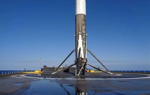
For the second time in less than a month, SpaceX has landed the first stage of a Falcon 9 rocket on a platform at sea, bringing the total of successful landings the company has so far achieved to three.
The landing came at 05:30 GMT on the morning of Friday, May 6th, just nine minutes after the rocket had lifted-off from Cape Canaveral Air Force Station in Florida on a successful mission to carry the Japanese communications satellite JCSAT-14 to orbit.
Following separation, the first stage of the Falcon 9 1a rocket performed a series of flight manoeuvres referred to as “boost back”, which culminated in the first stage making a successful touch-down on the deck of the drone ship Of Course I Still Love You, the same craft used to recover the first stage of the Falcon 9 rocket to lift the CRS-8 resupply mission to a safe rendezvous with the International Space Station in April.
The recovery of the booster stage was actually an unexpected event – SpaceX had believed that the nature of the mission would more than likely result in a failure to achieve a successful landing.
“Given this mission’s GTO [Geostationary Transfer Orbit) destination, the first stage will be subject to extreme velocities and re-entry heating, making a successful landing unlikely,” SpaceX representatives stated ahead of the launch.
The Falcon 9 1a first stage secured on the deck of Of Course I Still Love You, following the successful May 6th landing. Credit: SpaceX
Ideally, the company would like to bring all of its boosters back to a touch-down on land, as was the case with their first successful landing in December 2015. However, some mission profiles mean that the Falcon 9 cannot carry sufficient fuel reserves to complete a set of “boost back” manoeuvres that would be enough for it to make landfall, so some landings at sea are inevitable if SpaceX is to get anywhere close to recovering the majority of its launchers.
Nevertheless, with three successful landings under its belt, and three first stage rockets requiring refurbishment in order to be able to fly again, SPaceX boss Elon Musk jokingly conceded, in a Tweet made after the landing, “May need to increase size of rocket storage hangar!”
The “Boiling” Waters of Mars
An international team from France, the UK and the USA have produced the strongest evidence yet that the distinctive recurring slope lineae (RSL) features seen on the slopes of Martian craters are produced by liquid water. And not just any water; the study suggests the water is “boiling”.
RSLs have been the subject of intense debate and discussion since 2011; in essence, they are ridges and rills which appear on the slopes of hills and craters, notably in the equatorial regions of Mars during the summertime. The significance here being that on Earth, identical features are always the result of free-flowing water. As the “recurring” in the title suggests, the Martian RSLs appear to be active – frequently renewing themselves on a seasonal basis, with new RSLs sometimes also appearing at the same time.
Two images showing the flank of the same crater, revealing what appear to be active RSL, periodically renewed during the Martian summer. Credit: NASA/JPL
However, the low pressure of Mars’ atmosphere means that water cannot survive long on the surface unprotected: it will either freeze or sublimate. So the idea of it surviving long enough to create trails in the sides of craters had many scientists scratching their heads. Then, in 2015, a NASA study put forward evidence RSLs might actually be the result of water containing a strong suspension of mineral salts – magnesium perchlorate, magnesium chlorate and sodium perchlorate. Such minerals could be sufficient enough to prevent water exposed to the surface environment on Mars either immediately freezing or sublimating.
Building on this idea, the French-led international team used blocks of water ice containing the same minerals and placed them on the slope of a simulated Martian crater housed inside a special Mars Chamber at the Open University in the UK. When the pressure in the chamber was reduced to the ambient surface pressure on Mars and the temperature adjusted to a typical Martian summer’s day, the team found the ice would melt, producing a liquid mix which effectively “boiled” filtering into the sand and moving down-slope. As it did so. the resultant vapour “blasted” sand grains upwards, creating ridges which would collapse onto themselves when they became too steep, forming channels almost identical in form to Martian RSLs.
It’s been a while since there has been any major news from NASA’s Curiosity rover as it explores “Mount Sharp” in Gale Crater.
The last time I covered the rover’s activities, it was investigating a series of sand dunes which are slowly descending down the slopes of “Mount Sharp” as a result of a combination of gravity and wind action.
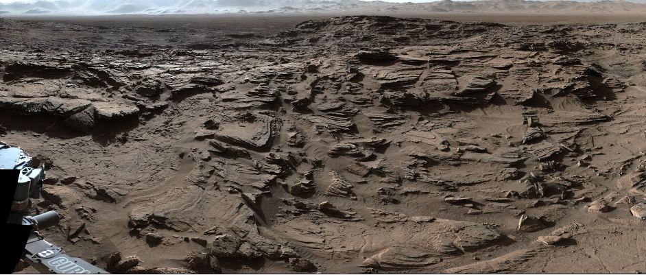
This work was completed in March, when the rover resumed its progress up the flank of the mound, climbing onto “Naukluft Plateau”, a roughly flat area cut into the side of “Mount Sharp” where aeons of wind erosion has carved the sandstone bedrock into ridges and knobs which were thought could offer a challenge for the rover in terms of wear and tear on the wheels.
The plateau lay between the rover and the next major area of scientific interest for the mission, so the drive team have been edging the rover across the rough terrain in the hope of reaching smoother ground on which it can continue upwards without exposing its six aluminium wheels to risk of severe damage.
“Naukluft Plateau”, which Curiosity has been traversing since March 2016, shown in close-up, revealing how the surface has been shaped and scoured by the wind over the aeons. In the distance can be seen the rim hills of Gale Crater. This image was captured om April 4th, 2016, the rover’s1,302nd Sol (Credit: NASA / JPL)
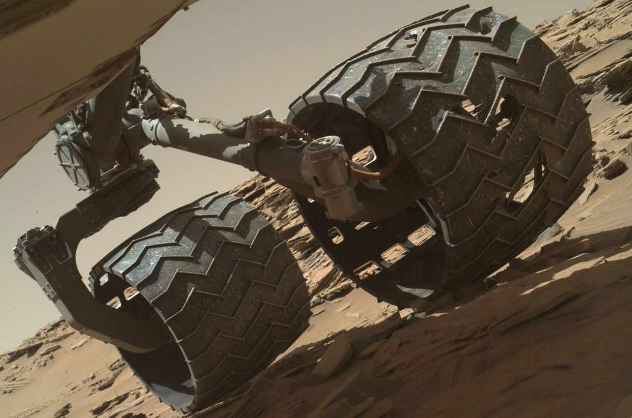
The roughness of the terrain on the plateau had raised concern that driving on it could be especially damaging to Curiosity’s wheels, as it is very similar to terrain the rover crossed in 2013 while en route to “Mount Sharp”, resulting in visible damage to some of Curiosity’s wheels, punching holes and tears into the aluminium, and prompting the mission team to undertake extensive tests on the wheels and their performance following such damage, using a duplicate of the rover here on Earth.
Because of the previous damage caused to the wheels, Curiosity was instructed to periodically image the condition of its wheels during the drive, a process which slowed progress but also revealed any damage being caused was not accelerating beyond what was projected to occur.
“We carefully inspect and trend the condition of the wheels,” said Steve Lee, Curiosity’s deputy project manager. “Cracks and punctures have been gradually accumulating at the pace we anticipated, based on testing we performed at JPL. Given our longevity projections, I am confident these wheels will get us to the destinations on Mount Sharp that have been in our plans since before landing.”
This image taken on April 18th, 2016 (Sol 1,315) by the Mars Hand Lens Imager (MAHLI) camera on the rover’s robot arm revels areas of damage on Curiosity’s centre left wheel, the result of periodically traversing very rough terrain since the rover arrived on Mars in 2012 (Credit: NASA / JPL)
In particular, the mission team is watching for breaks or tears which damage the zig-zag treads – called grousers – on the 50cm / 20 in wheels. If three of these grousers are significantly broken, Earth-based tests suggest the damaged wheel will have reached about 60% of its serviceable life.
However, since Curiosity’s current odometry of 12.7 km (7.9 mi) is about 60 percent of the amount needed for reaching all the geological layers planned in advance as the mission’s science destinations, and no grousers have yet broken, the accumulating damage to wheels is not expected to prevent the rover from reaching those destinations on Mount Sharp.
“Naukluft Plateau” is a part of the larger “Stimson formation” which includes a fracture area the rover reached a late April. Dubbed “Lubango”, the area was the target for the rover’s 10th drilling and sample gathering campaign, which was completed on Sol 1320, April 23rd, 2016.
“We have a new drill hole on Mars!” reported Ken Herkenhoff, a MSL science team member, when reporting on the sample gathering in an MSL update on April 28th.
After transferring the cored sample to the CHIMRA instrument for sieving it, a portion of the less than 0.15 mm filtered material was successfully delivered this week to the CheMin miniaturized chemistry lab situated in the rover’s body, which is now analysing the sample and will return mineralogical data back to scientists on earth for interpretation.
“Lubango” was selected for sample gathering after it had been determined following examination using the ChemCam laser and spectrometer, that it was altered sandstone bedrock and had an unusually high silica content. To complement the analysis of “Lubango”, the science team has been using the rover’s camera systems to locate a suitable target of unaltered Stimson bedrock as the 11th drill target.
“The colour information provided by Mastcam is really helpful in distinguishing altered versus unaltered bedrock,” MSL science team member Lauren Edgar explained in describing the current work. One possible target, dubbed “Oshikati” has been identified.
A white-balanced telephoto view of Gale Crater’s rim, as seen from the flank of “Mount Sharp” (Credit: NASA / JPL)
The ChemCam laser has already shot at the “Oshikati” to gather data for an initial analysis of the rock and assess its suitability for drilling operations. If all goes according to plan, Curiosity should make an attempt to gather samples from the rock on Sunday, May 1st.
SpaceX To Launch NASA-Supported Mars Mission in 2018
On April 27th, SpaceX announced it plans to launch an automated mission to Mars in 2018 as a part of a new space act agreement the company has signed with NASA. This will see the US space agency provide technical support to SpaceX with respect to an automated landing of a SpaceX vehicle on Mars, and provide scientific support for the mission.
An artist’s impression of Red Dragon arriving on Mars (credit: SpaceX)
SpaceX will undertake the mission using Red Dragon, an automated version of the Dragon 2 capsule vehicle which will enter service in 2018 to fly crews two and from the International Space Station.
Red Dragon has been on the drawing boards at SpaceX almost since the inception of the Dragon 2 programme. Designed to be launched atop the upcoming Falcon 9 Heavy launcher, due to enter operations later this year, it is specifically intended to carry science payloads almost anywhere in the solar system, and could potentially deliver as much as 4 tonnes of cargo to the surface of Mars (that’s the equivalent of delivering 4.5 Curiosity rovers to Mars in one go).
The 2018 mission is primarily intended to look at using a purely propulsive means of achieving a soft landing of a heavy vehicle on Mars. While parachutes could, in theory, be used to help slow a vehicle’s descent through the Martian atmosphere, recent NASA tests of the kind of large-scale “supersonic” parachutes required to slow large space vehicles during their descent haven’t proved overly successful during comparable testing at high altitude on Earth.
The Falcon 9 Heavy, which could lift scientific payloads aboard the Dragon 2 carrier vehicles almost anywhere in the solar system – compared to the current Falcon 9 (Credit: SpaceX)
Dragon 2 has been specifically designed so that a series of 8 rocket engines – called Super Draco motors – are embedded in the base of the vehicle. These can be used both as a launch abort system – firing a crew clear of a malfunctioning rocket during lift-off – and as a means of the vehicle achieving a “soft landing” on land rather than splashing down in the ocean (although the Dragon 2 is capable of this as well).
On Red Dragon, these super Draco motor allow the vehicle to slow itself down through its descent through the tenuous Martian atmosphere, and then act as a final cushioning break as the craft comes into land. Tethered tests here on Earth have already demonstrated Dragon 2 is fully capable of maintaining a hover until the thrust from the engines, and these tests will be expanded upon during the run-up to the mission.
The Red Dragon initiative is a commercial endeavour, funded entirely by SpaceX. NASA will not be contributing to the cost of the mission, but will be providing Earth-side logistical support and a suitable science payload of around 1 tonne. The exact nature of this payload will be defined in the future, but will likely include a diverse range of instruments which might be used to further characterise the Martian atmosphere, study and Martian weather and soil, and image the surface of Mars. Both SpaceX and NASA will share the data gathered during what is referred to as the EDL phase of the mission – the Entry, Descent and Landing. NASA will also supply a scientific payload for the flight.
Red Dragon marks the first phase of an ambitious programme SpaceX will be announcing in September, but which has been under development for about the last 6 years, for undertaking human missions to Mars in the 2020 / 2030s. I’ll have more on this later in the year.
Mars Odyssey: 15 years since launch and still going strong
Fifteen years ago, on April 7th, 2001, NASA launched their Odyssey mission to Mars. Since then, this orbital vehicle, whilst often overlooking in favour of its younger companions, Mars Express from Europe and NASA’s Mars Reconnaissance Orbiter, has done much to revolutionise our understanding of Mars.
Named for 2001: A Space Odyssey, the seminal science-fiction novel by Arthur C. Clarke, Odyssey arrived in orbit around Mars in October 2001. In doing so, not only did it overcome the failures of the 1999 Mars Climate Orbiter and Mars Polar Lander missions, it almost immediately scored its own major success: one suite of instruments found evidence for water ice close to the surface in large areas of Mars – as significant finding which has since gone on to shape much of our thinking about what lies within the Martian crust.
In 2010, Odyssey provided the highest-resolution (at that time) global map of Mars, stitched together from 21,000 images returned by the Thermal Emission Imaging System (THEMIS). Prior to that, in 2008 Odyssey spotted evidence of salt deposits across about 200 places in the south of Mars. NASA considers these areas to be signs of where abundant water used to sit. Scientists theorized the deposits could come from groundwater, which evaporated and left deposits of mineral behind. While in 2007, Odyssey imaged what appeared to be massive cave mouths on the surface of Mars.
THEMIS confirmed the openings – each between 100 to 250 meters (328 to 820 feet) across – were either vertical shafts running into the Martian crust or possibly openings leading to cavernous spaces beneath the surface. Dubbed the “seven Sisters” the openings were discovered on the flank of Arsia Mons, one of the gigantic Tharsis volcanoes, prompting speculation that they might be the collapsed roofs of lava tunnels within the volcano’s slopes.
A 2007 THEMIS image from Mars Odyssey showing entrances to possible Martian caves, dubbed the “seven sisters.” Clockwise from upper-left: Dena, Chloe, Wendy, Annie, Abbey, Nikki and Jeanne. Arrows signify direction of solar illumination (I) and direction of North (N) – Credit: GE Cushing, TN Titus, JJ Wynne, USGS, USGS, Northern Arizona University, and PR Christensen of Arizona State University
The vehicle has also operated in concert with the Mars Reconnaissance Orbiter in support of surface missions, including both the Curiosity and Opportunity rovers. As well as acting as a communications relay for such missions, Odyssey has been able to add context to the rovers’ work by providing thermal and other images which have helped science teams better understand the environments in which the rovers are operating. Nor does it end there. Odyssey has also been a careful observer of the Martian weather.
As each year on Mars lasts around 26 months, Odyssey has observed the planet through more than six Martian years. These observations have revealed some seasonal patterns that repeat each year and other seasonal events, such as large dust storms, which differ significantly from year to year.
A 2001 false colour map of Mars made from data gathered by Odyssey’s gamma ray spectrometer reveals the widespread distribution of hydrogen-enriched soil on Mars (in blue), the result of sub-surface ice deposits
In just this past year, Odyssey’s orbit has put the spacecraft in position to observe Mars in early morning light. Previously, the spacecraft flew over ground that was either in afternoon lighting or pre-dawn darkness. The new orbit enables studies of morning clouds and fogs and comparison of ground temperatures in the morning to temperatures of the same sites in the afternoon and pre-dawn, again helping to increase our understanding of the various atmospheric mechanisms operating on the planet.
With 15 years under its belt, Odyssey continued to work hard around Mars and shows no sign of stopping. So, happy anniversary, Odyssey!
On Land and Sea
Hard on the heels of Blue Origin’s third successful launch and recovery of their sub-orbital New Shephard capsule and propulsion module during a test flight, Elon Musk’s SpaceX has achieved what had been eluding them: launching a Falcon 9 rocket with a payload bound for the International Space Station and then landing the first stage of the rocket on a platform at sea.
The success comes after four prior attempted to land the first stage of the booster at sea – part of SpaceX’s efforts to develop a semi-reusable system to reduce overall launch costs – all ended with the booster crashing into the floating landing platform, or toppling over post touch-down.
The Falcon 9 1.1 furst stage of CRS-8 stands tall on the drone ship Of Course I Still Love You, following its landing on April 8th, 2016 (credit: SpaceX)
The April 8th launch, officially titled CRS-8, lifted-off from Cape Canaveral Air Force Station, Florida, at 8:53 GMT. After separating from the second stage of the rocket, which carrying the Dragon cargo craft up to orbit, the first stage of the booster performed a series of three burns to slow it down and boost it back towards the landing platform – referred to as an autonomous drone ship – that was keeping station downrange of the launch site. Eight and a half minutes after the launch, the first stage made a vertical descent over the platform, re-firing its main engines to slow itself as the landing legs deployed from along the side of the rocket’s body, and it eased into a gentle touch-down.
After the landing, crew boarded the platform to weld the rocket’s landing pads to the deck as a precaution against it toppling over while the platform was being towed back to port. Current plans call for the platform to undergo examination and testing at Kennedy Space Centre to ensure no structural damage occurred during the landing, before it is refurbished for a further at-sea landing, possibly in June 2016. The Falcon booster stage will also undergo post-flight examination prior to being refurbished for a future launch.
The Dream Chaser flight test article alongside NASA’s space shuttle Atlantis in 2010 (image: NASA / SNC)
NASA has announced a renewal to the current US private sector contracts to provide uncrewed resupply missions to the International Space Station (ISS) – and it came with something of a surprise.
SpaceX and Orbital ATK are the two US companies currently flying cargo resupply missions to the ISS, operating alongside Russian Progress vehicles and the Japanese H-II “Kounotori” Transfer Vehicle. Europe, which previously operated the largest cargo vehicle, the Automated Transfer Vehicle, ended ISS resupply missions in February 2015, and is now focused on supplying NASA with the Orion Service Module.
Both SpaceX, who can both launch and return up to 3.3 tonnes of cargo and trash to / from the space station using their Dragon cargo vehicle, and Orbital ATK,who can transport up to 3.5 tonnes of cargo / trash aboard their Cygnus vehicle (which burns-up on re-entering Earth’s atmosphere) have their resupply contracts renewed from 2019 through 2024, matching the extended lifetime of ISS operations. While this had been expected, the inclusion of a third vehicle, the Dream Chaser vehicle being developed by Sierra Nevada Corporation SNC surprised some.
Dream Chaser was unique among the commercial crew transportation proposals as it was based on a “lifting body” design rather than a capsule system. Although launched atop a conventional rocket, the design allows it to re-enter the Earth’s atmosphere and glide to a landing on a conventional runway, making it an exceptionally versatile craft (image: SNC)
Dream Chaser was originally designed as part of NASA’s Commercial Crew Development (CCDev) programme aimed at having private sector companies provide the means of carrying crews back and forth between the space station and US soil. One of four proposals put to NASA under the programme, it was ruled out of the final selection in September 2014, with SpaceX and Boeing being chosen by NASA despite the fact that on paper, Dream Chaser offered potentially a better deal than Boeing’s CT-100 capsule.
While SNC lodged a complaint with the US Government Accountability Office (GAO) as a result of the decision, citing interference in the selection process by William Gerstenmaier, NASA’s top human exploration official, the GAO upheld the selection of SpaceX and Boeing for the crewed transport vehicles. However, NASA continued to work with SNC on various ideas for Dream Chaser, alongside of SNC looking at other options for the vehicle’s crew carrying capabilities to be put to use.
An artist’s concept of the Dream Chaser Cargo docked with the ISS during a resupply flight (image: SNC)
The new resupply contract will see SNC provide NASA with the uncrewed “Dream Chaser Cargo” variant of the vehicle, capable of flying up to 5 tonnes of cargo to / from orbit, As with the original crewed variant, the Dream Chaser Cargo will launch atop a rocket, but return to earth to make a conventional runway landing.
How many missions each of the three resupply vehicle types will fly is unknown; vehicles will be selected on the basis of flight / payload requirements and cost. The total cost of the contract, spilt between the three companies, is expected to be US $14 billion over the 5 years.
The Ice Volcanoes of Pluto
Scientists with NASA’s New Horizons mission have assembled the highest-resolution colour view of one of two potential cryovolcanoes spotted on the surface of Pluto, as the spacecraft hurtled by the little world in July 2015.
Informally called “Wright Mons”, the feature is about 150-160 kilometres (90-100 miles) across at its base, and about 4 km (2.5 miles) high. If it is in fact a volcano, it will be the largest such feature discovered in the outer solar system.
The feature has members of the New Horizons science team intrigued on two counts. The first is that there is a very sparse distribution of red material on its flanks. The second is that it apparently only has a single impact crater. This latter point suggests “Wright Mons” is relatively new surface feature on Pluto, while the former might suggest it is active, with ice ejected by eruptions covering the red material over time.
“Wright Mons” (the large dimple in the image on the right) and as seen in context with the rest of Pluto, may be one of two enormous cryovolcanoes on the tiny world (image: NASA/JPL / JHU/APL / SwRI)
The images of “Wright Mons” were returned to Earth from New Horizons in November 2015. Since then, data from the Ralph instrument suite aboard the spacecraft has been used to add the colour details to the images, which have been composed into a new mosaic of the feature. If it and “Piccard Mons” are cryovolancoes, then they present further evidence that Pluto was (and might still be) geologically active.
NASA’s Mar Science Laboratory rover, Curiosity, continues to perform the first up-close study ever conducted of extraterrestrial sand dunes as it slowly explores the slopes of “Mount Sharp” dubbed the “Bagnold Dunes”.
Located on the north-west slope of the mound which lies at the centre of Gale Crater, the dunes differ from those drifts and sand fields the rover has previously encountered on Mars in terms of both their size and height – some cover an area the size of a football field and are 2 storeys high – and their general shape, something which marks them out as “classic” sand dunes.
This latter point is most evident by the dunes exhibiting a steep, downwind slope, referred to as the slip face, and which exhibits certain features of its own, such as gain fall, ripples and grain flow, as well as the dune as a whole exhibiting typical features such as the horn and toe.
For the last couple of weeks, the rover has been working its way around one dune in particular, dubbed “Namib”, which is somewhat smaller than the “high dunes” images at the start of December, but which still rises to a height of some 5 metres (16 ft). The leeward side of “Namib” in particular demonstrates the classic features of a sand dune, and helps to confirm the fact that the dunes are slowly progressing down the slope of “Mount Sharp” at a rate of about 1 metre (39 inches) a year.
The leeward side of “Namib”:Horn – where sand is escaping the main dune and escaping downhill, as indicated by the ripples; Toe – the downwind extent of the dune; ripples – signs of the sand bouncing sideways over the dune as the wind blows it downslope towards the horn; Brink – the ridge between the windward, gentle slope of the dune and the leeward, steeper slope of the dune; Grail Fall – areas where sand is blown / falls from the brink and comes to rest on the leeward slope; Gain Flow – tongue-like area indicating where large amounts of sand have slumped down the side of the dune towards the toe, again indicative of a dune in motion
The dune-investigation campaign is designed to increase understanding about how wind moves and sorts grains of sand in an environment with less gravity and much less atmosphere than well-studied dune fields on Earth. Such an understanding of how the wind moves sand could lead to a clearer picture of how big a role the Martian wind played in depositing concentrations of minerals often associated with water across the planet, and by extension, the behaviour and disposition of liquid water across Mars.
This rather odd-looking image is a foreshortened 360-degree view of the area around Curiosity. In the immediate foreground is the rover’s main deck, with the cylindrical, finned nuclear RTG at the back of it. Beyond this is the “Namib” dune, with a taller dune beyond it. The view was constructed from a series of images taken by the rover’s Mastcam on December 18th, 2015 (Sol 1,197 on Mars), all of which have been white-balanced to present the view under normal Earth daylight conditions
Back to Sea for SpaceX
SpaceX, the private space launch company, is keeping itself busy. Following the successful launch of the Orbcomm mission from Florida’s Cape Canaveral Air force Station, together with the successful recovery of the first stage of the booster when it flew back to the Cape and performed a flawless vertical landing, the company’s next launch is scheduled for Sunday, January 17th.
The launch will take place from Vandenberg Air force Base, California, which is the company’s Pacific Coast launch operations centre. The primary aim of the mission is to place the third in a series of joint U.S.-European satellites into a near-polar orbit (for which Vandenberg AFB is ideally suited, as a polar launch from there does not pass over inhabited land during ascent, lessening the risk to human lives should a launch vehicle suffer a failure).
The Jason-3 series of missions is part of a very long-term series of studies (started in 1992) to study the topography of the ocean surface (i.e. the formation and movement of waves and the troughs between them), which can provide scientists with critical information about circulation patterns in the ocean, and about both global and regional changes in sea level and the climate implications of a warming world.
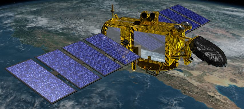
Jason-3, the latest in a series of joint US-European satellites studying the topography of the ocean’s surface, is due for launch on December 17th, 2016, using a SpaceX Falcon 9 1.1 rocket (image: NASA / CNES)
The polar orbit used for this kind of earth-observing mission, being almost perpendicular to the Earth’s rotation, allows the spacecraft to at some point travel over almost every part of the world’s oceans, vastly increasing its ability to gather data when compared to a vehicle in an equatorial orbit.
What is also significant about the mission is that it will use a SpaceX Falcon 9 1.1 booster, the first stage of which will once again attempt to return to Earth and make a safe landing. However, unlike the December 2015, this landing will once again be at sea, using a SpaceX droneship landing platform.