November 23rd, 2015: moments before touchdown: the Blue Origin propulsion module, having lobbed a New Shephard capsule on a sub-orbital flight, powers its way to a historic landing so it can be refurbished and re-used (image: Blue Origin)
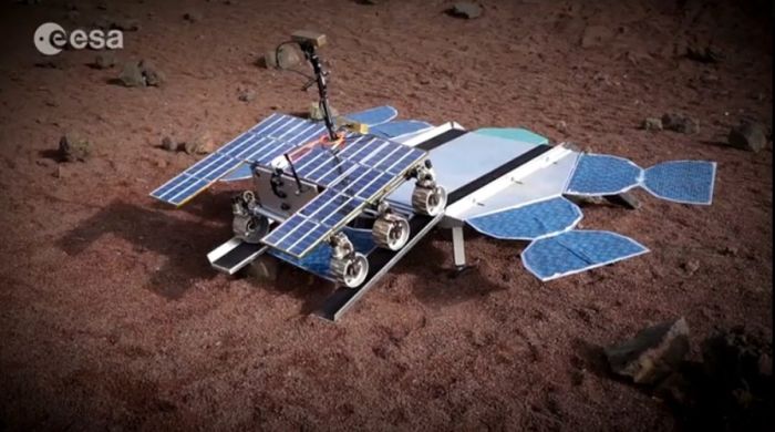
Blue Origin, the private space company founded by Amazon billionaire Jeff Bezos has become the first company to successfully launch a rocket into space – and return all elements of the vehicle to Earth for re-use.
The flight, carried out in West Texas, took place on Monday, November 23rd. It comprised the company’s New Shephard capsule, being flown in an uncrewed mode, and a single stage, recoverable booster is powered by an engine also developed by the company.
Unlike SpaceX, Orbital Sciences, Boeing and Sierra Nevada Space corporation, all of whom are directly pursuing rocket and space vehicle designs capable of orbital flight, Blue Origin is taking a more incremental approach, with efforts focused on the sub-orbital market “space tourism” market. The company is looking to build a cost-effective launch system capable of lifting small groups of paying passengers into space on ballistic “hops” which allow them to experience around 4-5 minutes of zero gravity before returning them to Earth.
The November 23rd flight saw the uncrewed New Shephard vehicle hoisted aloft by the booster system which reached a speed of Mach 3.72, sufficient for it to impart enough velocity to the capsule so that it could, following separation, continue upwards to an altitude of 100.5 kilometres (329,839 feet), before starting its descent back to the ground and parachuting to a safe landing.
April 25th: A camera aboard the propulsion module captures the rear of the New Shephard capsule moments after separation in the first test flight intended to recover both capsule and launcher – although the latter was in fact lost on that flight (image: Blue Origin)
Following capsule separation, however, the booster rocket Also made a control descent back to Earth, rather than being discarded and lost. The design of the booster – which Blue Origin call the “propulsion module” to differentiate to from a “simple” rocket – means it is semi-capable of aerodynamic free-fall, and won’t simply topple over and start tumbling back to Earth. At 6.5 kilometres (4 miles) above the ground, a set of eight drag brakes are deployed to slow the vehicle, with fins along the outside of the module allowing it to be steered. At 1.5 kilometres (just under 1 mile) above the landing pad, the unit’s motor reignites, further slowing it to a safe landing speed and allowing it to precisely manoeuvre itself onto the landing pad.
Highlights of the actual test flight, mixed with computer-generated scenes of the New Shephard capsule carrying a group of tourists on their sub-orbital hop was released by Blue Origin on November 25th.
One of the first to congratulate Blue Origin on their flight was Elon Musk, the man behind SpaceX, which is also pursuing the goal of building a reusable rocket system, but had yet to achieve a successful recovery of the first stage of their Falcon 9 booster. However, as Musk pointed out, there are significant differences and challenges involved in bringing a sub-orbital launch back to Earth and a booster which has to reach far higher velocities in order to lob a payload into orbit, as SpaceX is already doing.
Not that Blue Origin doesn’t have orbital aspirations; both the “propulsion module” and New Shephard are designed to be integrated into a larger launch vehicle capable of placing the capsule into orbit. The November 23rd flight itself marks the second attempt to launch and recover both New Shepard and the propulsion module; in April 2015, the first attempt succeeded in recovering the capsule, but a failure in the drag brake hydraulic system on the propulsion module resulted in its loss.
Martian Moon Starting Slow Breakup?
A Mercator map of Phobos showing the complex system of groves and potential lines of fracture across the little moon. Some of these, notably those located close to it, are thought to be the result of the impact which created Stickney crater (left of centre in the map); however most of them seem to be the first indications that Phobos is starting to slowly break-up (image: US Geological Survey)
Mars has two natural moons, Deimos and Phobos. Neither are particularly large; Deimos is only 15 × 12.2 × 11 km in size, and orbits Mars once every 30 hours; Phobos measures just 27 × 22 × 18 km, and orbits the planet once every 7 hours and 39 minutes. Both exhibit interesting properties, in that Deimos is slowly moving away from Mars, and may even break from Mars’ influence in a few hundred million years.
Phobos, however is doing the reverse; it is gradually closing in on Mars at a rate of about 2 metres (6.6 ft) every 100 years. This means that over time, it is being exposed to greater and greater gravitational forces as it approaches its Roche limit.
The Mars Science Laboratory rover, Curiosity, continues to climb the flank of “Mount Sharp” (formal name: Aeolis Mons), the giant mount of deposited material occupying the central region of Gale Crater around the original impact peak. For the last three weeks it has been making its way slowly towards the next point of scientific interest and a new challenge – a major field of sand dunes.
Dubbed the “Bagnold Dunes”, the field occupies a region on the north-west flank of “Mount Sharp”, and are referred to as an “active” field as they moving (“migrating” as the scientists prefer to call it) down the slops of the mound at a rate of about one metre per year as a result of both wind action and the fact they are on a slope.
Curiosity has covered about half the distance between its last area of major study and sample gathering and the first of the sand dunes, simply dubbed “Dune 1”. During the drive, the rover has been analysing the samples of rock obtained from its last two drilling excursions and returning the data to Earth, as well as undertaking studies of the dune field itself in preparation for the upcoming excursion onto the sand-like surface.
While both Curiosity and, before it, the MER rovers Opportunity and Spirit have travelled over very small sand fields and sand ripples on Mars, those excursions have been nothing like the one on which Curiosity is about to embark; the dunes in this field are huge. “Dune 1”, for example, roughly covers the area of an American football field and is equal in height to a 2-storey building.
“dune 1” in the “Bagnold Dunes”, imaged here by the High Resolution Imaging Science Experiment (HiRISE) camera on NASA’s Mars Reconnaissance Orbiter (MRO) is roughly 300 metres across and as tall as a 2-storey building. The image is in false colour, combining information recorded by HiRISE in red, blue-green and infra-red frequencies of light.
While the rover will not actually be climbing up the dune, it will be traversing the sand-like material from which it is formed and gathering samples using the robot arm scoop. This is liable to be a cautious operation, at least until the mission team are confident about traversing parts of the dune field – when Curiosity has encountered Martian sand in the past, it has not always found favour; wheel slippage and soft surfaces have forced a retreat from some sandy areas the rover has tried to cross.
Study of the dunes will help the science team better interpret the composition of sandstone layers made from dunes that turned into rock long ago, and also understand how wind action my be influencing mineral deposits and accumulation across Mars.
On Earth, the study of sand dune formation and motion, a field pioneered by British military engineer Ralph Bagnold – for whom the Martian dune field is named – did much to further the understanding of mineral movements and transport by wind action. Understanding how this might occur on Mars is important in identifying how big a role the Marian wind played in depositing concentrations of minerals often associated with water across the planet, as opposed to those minerals accumulating in those areas as a direct consequence of water once having been present.
A mosaic of images taken on September 25th, 2015 (Sol 1,115) captures by the right lens of the rover’s Mastcam system. .The view is toward south-south-west and reveals the “Bagnold Dunes” as a dark band across the middle of the image, blending with mesas beyond them
Next NASA Rover to Have its Own Drone?
In January I wrote about ongoing work to develop a helicopter “drone” which could operate in concert with future robot missions to Mars. Now the outgoing director of NASA’s Jet Propulsion Laboratory has indicated the centre would like to see such a vehicle officially included as a part of the Mars 2020 rover package.
Weighing just one kilogramme (2.22 pounds) and with a rotor blade diameter of just over a metre (3.6 feet), the drone would be able to carry a small instrument payload roughly the size of a box of tissues, which would notably include an imaging system. Designed to operate as an advanced “scout”, the drone would make short daily “hops” ahead of, and around the “parent” rover to help identify safe routes through difficult terrain and gather data on possible points of scientific interest which might otherwise be missed and so on.
Since January, JPL has been continuing to refine and improve the concept, and retiring JPL Director Charles Elachi has confirmed that by March 2016, they will have a proof-of-concept design ready to undergo extensive testing in a Mars simulation chamber designed to reproduce the broad atmospheric environment in which such a craft will have to fly. The centre hopes that the trials will help convince NASA management – and Congress – that such a drone would be of significant benefit to the Mars 2020 mission, and pave the way for developing drones which might be used in support of future human missions on the surface of Mars.
Mars has been in the news a lot this last week, thanks to both the Curiosity rover and the MAVEN orbiter.
Curiosity’s science capabilities received a boost when a upgrade to the ChemCam test system on Earth increased the number of Earth-rock geochemical samples examined by the system tripled to some 350, vastly increasing the science team’s ability to improve their interpretation of data gathered by Curiosity’s ChemCam system – the laser and telescope / camera which vaporises small amounts of rocks on Mars and them images the plasma that’s given of for chemical and mineralogical analysis.
In particular, the upgrade has allowed the science team to re-examine data the rover gathered about a site with the most chemically diverse mineral veins so far examined on Mars. Called “Garden City”, the site sits above the “Pahrump Hills” area at the foot of “Mount Sharp”, which the rover examined in detail in late 2014 / early 2015. Of particular interest to scientists were a series of raised mineral veins criss-crossing the surface of the rocks in the area.
“Garden City”, an outcrop about 1 metre (39 inches) high, examined by Curiosity in March 2015, and which exhibited mineral veins criss-crossing the surface of the rocks, and which exhibited different chemical signatures. New analysis capabilities on Earth have helped determine how the veins formed and what they may say about early conditions in Gale Crater
These new Earthside capabilities have allowed the science team to better analyse the minerals within the veins and make finer distinctions between them, revealing their mineral and chemical compositions vary one to another, and also appear to vary with age.
These findings suggest that, rather than being the result of a single extended wet period in Gale Crater during which water percolated down through fissures in the rock to leave the minerals behind, the veins are the result of several individual wet periods in Mars’ ancient past. These wet periods appear to have occurred somewhat later than the more extensive wet periods which gave rise to a successive series of lakes within Gale Crater, the sediments from which form the lowest slopes of “Mount Sharp”. As such, the veins give further hints to atmospheric changes going on at a time at which Mars’ climate was undergoing extraordinary changes and fluctuations in its ancient past.
Prominent mineral veins at the “Garden City” site examined by NASA’s Curiosity Mars rover vary in thickness and brightness, as seen in this image from Curiosity’s Mast Camera (MastCam). The image covers and area roughly 60 cm (24 inches) across, and shows a mix of thin, dark-toned fracture filling material, likely deposited first, thick, dark-toned vein material in large fractures, and light-toned vein material, which was deposited last.
What Happened to Mars’ Atmosphere? The Answer is Blowin’ in the Wind
Atmospheric changes are also at the heart of the latest data to be analysed from NASA’s Mars Atmosphere and Volatile Evolution (MAVEN). This data, part of the mission’s long terms studies of the planet’s atmosphere and environment greatly clarifies the key role played by the solar wind in the gradual loss of Mars’ once dense atmosphere and the transition of the planet’s climate from a warm and wet environment to the cold, arid planet we see today.
The solar wind is a stream of particles, mainly protons and electrons, flowing from the Sun’s atmosphere at a speed of about 1.6 million kilometres (1 million miles) per hour. The interaction of this solar wind generates an electric field around Mars, much like a turbine on Earth generates electricity. This electric field interacts with the upper reaches of Mars’ atmosphere, accelerating the ions there and shooting them into space.
An artist’s impression of the solar wind shredding ions from Mars’ atmosphere
MAVEN measurements indicate that gases are being stripped away in this manner from the Martian atmosphere at a rate of about 8.6 million tonnes per day. “Like the theft of a few coins from a cash register every day, the loss becomes significant over time,” said Bruce Jakosky, MAVEN principal investigator. “We’ve seen that the atmospheric erosion increases significantly during solar storms, so we think the loss rate was much higher billions of years ago when the sun was young and more active.”
The impact of solar storms on the rate of loss from Mars’ atmosphere was directly observed by MAVEN at the start of 2015, when the planet was bracketed by a series of large-scale outpouring from the sun – the same solar activity which gave rise to the massive increase in auroral activity at that time (see my October 26th Space Sunday report).
“Solar-wind erosion is an important mechanism for atmospheric loss, and was important enough to account for significant change in the Martian climate,” Joe Grebowsky, MAVEN project scientist said of the data gathered by the mission. “MAVEN also is studying other loss processes – such as loss due to impact of ions or escape of hydrogen atoms – and these will only increase the importance of atmospheric escape.”
When discussing Mars exploration, it is easy to forget that NASA, the US space agency is far from alone. Both Europe and India are currently operating vehicles in orbit around Mars, while in 2004, the European Space Agency became only the third agency in the world to attempt a landing on Mars, when the British built Beagle 2 mission separated from its Mars Express parent craft but unfortunately failed to safely arrive on the surface of Mars.
Mars Express has gone on to be one of the most successful Mars orbital mission on record, carrying out a range of duties similar to those of NASA’s Mars Reconnaissance Orbiter (MRO), which it preceded to Mars by some two years. Now approaching the end of its 12th year in operation around the planet, Mars Express continues to return a wealth of data to Earth and also functions as a back-up communications relay for the two NASA rovers currently operating on the surface of the Red Planet.
An artist’s impression of Beagle 2 on Mars (image: European Space Agency)
Quite what happened to Beagle 2 remained unknown until early in 2015. It had been thought the tiny lander, just 1 metre (39 inches) in diameter but packing a huge amount of science capabilities into it, had been lost as a result of burning up in Mars’ tenuous atmosphere or as a result of its parachute landing system or air bags failing. However, as I reported in January 2015, images captured by NASA’s MRO revealed Beagle 2 had landed quite safely, but one of its solar panels failed to deploy, preventing the craft from communicating with Mars Express and Earth.
In 2018, ESA, working in conjunction with the Russian Federal Space Agency, Roscosmos, plan to overcome Beagle 2’s failure to gather science from the surface of Mars with a rover vehicle called ExoMars Rover, part of an ambitious 2-phase mission itself entitled “ExoMars”, and which commences in 2016.
ESA’s ExoMars TGO: due for launch in March 2016, part of a 2-phase mission to search for direct evidence of life, past or present, on Mars. In this artist’s impression, the capsule-like Schiaparelli has already been detached from the circular base of the vehicle (image: European Space Agency)
The first part of the mission will commence in March 216 with the launch of the ExoMars Trace Gas Orbiter (TGO), a telecommunications relay orbiter and atmospheric gas analyser mission. This will arrive in orbit around Mars in December 2016 and will proceed to map the sources of methane on Mars, as well as analyse and study other trace gases. Methane is of particular interest to scientists its likely origin is either present-day microbial life existing somewhere under the surface of the planet, or the result of geological activity. Confirmation that either is the cause would be of significant scientific benefit.
Whilst in operation in Mars obit, TGO will deploy Schiaparelli, an Entry, Descent and Landing Demonstrator Module (EDLM). This is intended to test some of the key technologies needed to safety see a rover-carrying lander onto the surface of Mars, such as the ability to control touchdown orientation and velocity. Most uniquely, the landing will take place during the Martian dust storm season, presenting scientist with the opportunity to characterise a dust-loaded atmosphere during entry and descent, and to conduct surface measurements associated with a dust-rich environment.
The Advanced Prototype ExoMars Rover undergoing remote deployment testing in 2015 (image: European Space Agency)
The 2018 ExoMars Rover mission, although yet to be finalised, is primarily designed to find evidence of microbial life, past or present, under the Martian surface. It is provisionally scheduled for launch in May 2018, although this may be delayed until August 2020, around the time NASA Mars 2020 rover mission is due to fly.
The ExoMars vehicle is somewhat larger than NASA’s solar-powered Opportunity rover, but at some 207 kg (456 lb), is about one-third the mass of Curiosity and the Mars 2020 rover. A unique aspect to ExoMars Rover is that it will carry a drilling system aboard which, for the first time, will allow samples to be obtained from almost 2 metres (6.5 ft) below the surface of Mars. The rover is expected to operate for around 6-7 months, but could remain operational for much longer. During that time, it should cover a distance of around 4 km (2.5 mi), after landing in early 2019.
The four proposed landing sites for ExoMars Rover. The colours on the map represent the relative elevations of surface features on Mars. White / Red refer to the highest elevation, such as the Tharsis Bulge and the great volcanoes to the north-west, and blue the low-lying regions, such as the far northern latitudes and the great impact basin of Hellas in the south-east, which likely caused the Tharsis Bulge upwelling
In September I reported on images captured by the New Horizons space probe of the night side of Pluto, backlit by the distant Sun. In a follow-up to those images, the New Horizons team has released stunning high-resolution images captured by the probe shortly after passing the point of closest approach to Pluto on July 14th, 2015.
The images were captured from a distance of just 18,000 km (11,000 miles) from Pluto using the Multi-spectral Visible Imaging Camera (MVIC), part of New Horizon’s Ralph suite of instruments, which were pieced together to form a magnificent view of Pluto with a resolution of some 700 metres per pixel.
The mosaic of images shows the rich complexity of both Pluto’s surface features and its atmosphere, the enhanced images clearly bringing the bands of haze in the latter into sharp relief.
An enhanced image of Pluto’s night side, composed of images captured by the MVIC instrument on New Horizons on July 14th, 2015. As Pluto is “tipped over” on its axis by 120 degrees, the planet’s north pole is to the right and south pole to the left (image: NASA/JPL / JHUAPL / SwRI)
The clearest detail of Pluto’s surface can be seen to the right, which because the planet’s axis is tilted by 120-degrees, is the north polar region. The sheer ruggedness of the terrain can be seen here, some of the pitted hills almost looking like clouds above a distant landscape. However, the left side, and the south pole isn’t entirely without interest: caught by the glow of sunlight refracted by Pluto’s tenuous atmosphere, the rugged nature of the little world’s chaotic surface can also be seen.
Subject to enhancement, a portion of the images capturing the northern regions of Pluto reveal even more detail, particularly within the complex layering of Pluto’s atmosphere, where the enhancements reveal it to be made up of around a dozen layers, far more than had been thought during New Horizon’s final approach to Pluto in late June. These layers are made up of tholins, soot-like organic compounds created as a result of ultraviolet radiation from the sun interacting with the upper layers of Pluto’s atmosphere. These particles, undergoing some chemical changes as they drift back down through the various layers, eventually precipitate down onto Pluto’s surface, staining it red.
An enhanced image of Pluto north polar region revealing an incredibly complex surface of hills and valleys, ice features and high mountains, while above can be seen an enhanced view of the complex atmospheric banding (image: NASA/JPL / JHUAPL / SwRI)
Cassini’s Enceladus Encounter
Cassini, NASA’s deep space probe exploring Saturn and his retinue of moons as a part of the Cassini-Huygens mission, is approaching the end of its 20-year mission. Launched in 1997, and following a 7-years transit to Saturn, Cassini has been studying the system in great detail, and delivered a tiny European lander vehicle, Huygens, to the surface of Titan, the largest moon in the solar system, and one with its own rich atmosphere, and standing bodies of liquid on its surface.
With fuel reserves set to expire in late 2017, Cassini will be ordered to fly into Saturn’s own dense atmosphere before it does so, where it will burn-up. In the meantime, however, the vehicle continues to return a marvellous wealth of data about the Saturn system, including several studies of another of the giant planet’s remarkable moons, Enceladus.
Enceladus revealed: captured on October 28th, this image reveals the icy beauty of the moon as Cassini closes for its penultimate, and closest, approach (image: NASA/JPL / Space Science Institute)
Like Jupiter’s moon Europa, Enceladus is a domain of ice, under which likely sits an ocean of liquid water. Shortly after arriving in orbit around Saturn, Cassini made the first of numerous flybys of the little Moon, which is just 500 km (310 mi) across, and detected the presence of a very thin atmosphere primarily made up of water vapour. In particular, the craft observed geysers erupting from the south pole, spewing water vapour, ice particles and other material into space, some of which likely contributes to Saturn’s “E” ring.
At the end of October 2015, Cassini made its penultimate flyby of Enceladus, passing over the Moon at an altitude of just 48 km (30 mi) and at a speed of some 30,000 kph (19,000 mph), diving through another of the geyser plumes in the process to measure the composition of gas and ice particles launched from the underground ocean.
A stunning images taken by Cassini following the October flyby reveals a crescent Enceladus floating above Saturn’s magnificent rings (image: NASA/JPL / Space Science Institute)
In particular, the Cassini science team will be analysing the data returned by Cassini following the flyby to see if the sensors found any evidence of molecular hydrogen in the plumes. Doing so would help verify suspected hydrothermal activity is taking place on the floor of Enceladus’ ice-shrouded ocean which could give rise to hot environments rich in mineral and chemical deposits suitable for the development of microbial life, just as deep-ocean thermal vents here on Earth provide life-sustaining environments.
Cassini will make one more return to Enceladus on December 19th, but will pass further from the little Moon as its orbit gradually swings it around Saturn for a further and final set of encounters with giant Titan, before finally moving inwards to pass between Saturn and its rings for the first time to study Saturn’s atmosphere in detail as the mission draws to a close in 2017.
Dawn Descends Over Ceres
On October 23rd, the NASA / ESA joint mission to explore two of the solar system’s three “protoplanets” located in the asteroid belt between the orbits of Mars and Jupiter, commenced manoeuvres to lower itself to is final orbit around Ceres.
The Dawn spacecraft, which arrived at Ceres in March 2015, after a 2.5 year transit flight from Vesta, its first destination, fired its ion engine to start reducing its orbit from 1,450 kilometres (915 miles) to just 380 km (235 mi), a manoeuvre which should see the vehicle spiral gently downwards to arrive in its new orbit in mid-December. At that time, Dawn will commence a final mapping and data-gathering mission, providing images with a resolution of 35 metres (120 ft) per pixel.
Occator crater and its bright spots images from directly overhead and a distance of 1,450 km (915 miles) by the Dawn space vehicle (image: NASA / JPL / DLR)
It is hoped that this final science orbit will offer definitive data on precisely what is giving rise to a series of odd bright spots within the crater Occator on Ceres, and which appear to be related to what seems to be a small and very localised trace atmosphere within the crater. Current thinking is the bright markings are salt or ice water deposits which are being out-gassed from Ceres’ interior.
Britain’s Spaceplane Gets £80 million Investment
SABRE is the name of a radical “air-breathing” hybrid engine which has been in development by a small British company called Reaction Engines Limited (REL) since the late 1990s. The aim is to reduce the amount of on-board oxidiser required in the rocket combustion process by allowing the engine to draw on the air around it during the initial ascent through the denser part of the Earth’s atmosphere, much like a regular jet engine uses the air around it. Only when the air becomes too thin to support combustion does the rocket engine switch over to its on-board supplies of liquid oxygen to burn with its liquid hydrogen fuel.
Ultimately, REL hope to use the SABRE engine in a single stage to orbit (SSTO) vehicle called Skylon, a fully reusable space launch vehicle, capable of operating from and to a conventional runway just like an aeroplane, and carrying up to tonnes into low Earth orbit. However, the SABRE engine potentially has a wide range of applications, including a purely “air-breathing” variant (called Scimitar) which could be used to power aircraft within Earth’s atmosphere at speeds close to five times that of sound.
REL propose using the SABRE engine in their Skylon spaceplane capable of lifting up to 15 tonnes (cargo or 24 passengers) into orbit. however, the engine has many potential uses, hence the interest from BASE Systems and the UK government (image: REL)
On Monday, November 2nd, REL announced that BAE Systems Ltd is to invest some £20.6 million (US $31.8 million) in REL in return for a 20% stake in the company, while the UK government has awarded a further £60 million (US $92.8 million). Together with recent funding from the EU, REL has now raised some £95 million (US $146.6 million) to further develop SABRE.
Skulls in the Sky
Halloween 2015 brought with it a creepy-looking visitor which looked down on Earth as many across the world took to marking All Hallows Eve on Saturday, October 31st.
The visitor in question was asteroid 2015 TB145, a lump of rock around 600 metres (1,968 feet) across. Tumbling through space, it passed by the Earth at a distance of roughly 480,000 km (300,000 miles) – slightly further from us than the orbit of the Moon, at a speed of some 126,000 kph (78,293 mph).
Such Earth-passing asteroids are not rare, although this one was only identified on October 10th, 2015. It well be the last close passage to Earth by a very large asteroid until 2027, and its size offered scientists a unique opportunity to image it using radar.
Asteroid 2015 TB145 in an eerily skull-like image captured by the Arecibo Observatory on Friday, October 30th, 2015.
On Friday, October 30th, the The Arecibo Observatory in Puerto Rico used radar mapping to capture an image of the asteroid in which it looks like a gigantic skull. It was all an optical illusion of course, the combined result of the radio reflections from the asteroid giving rise to the grey shaded image and the effect of pareidolia, in which the human brain perceives shapes and patterns that aren’t really there; as the asteroid tumbled through space, the similarities to a human skull were quickly lost as the radar reflections changed.
Nevertheless, it was fittingly spooky for Halloween!
Discover Gale Crater
I’ve written extensively about NASA’s Curiosity rover and its explorations within Gale Crater on Mars since its arrival there in August 2012. Now NASA and the Los Angeles Times have combined to provide a virtual reality exploration of Gale Crater, which examines some of the principal features to be found there, traces the rover’s route from crater floor and up the flank of “Mount Sharp” and which allows visitors to fly over the crater or take a guided tour using simple keyboard controls.
The Curiosity rover team have released a further study showing that ancient Mars was capable of storing water in lakes over an extended period of time, and that this water was a principal component in the creation of “Mount Sharp”, the mound at the centre of Gale Crater, currently being investigated by the NASA rover.
This forms the latest in a series of reports on the subject of water on Mars and in Gale Crater to be published by the Curiosity science team, and comes almost a year after I wrote about studies released by the team which detailed how “Mount Sharp” – more formally known as Aeolis Mons – was most likely formed by sediments laid down by successive wet period in Mars’ ancient past.
“Observations from the rover suggest that a series of long-lived streams and lakes existed at some point between about 3.8 to 3.3 billion years ago, delivering sediment that slowly built up the lower layers of Mount Sharp,” said Ashwin Vasavada, Mars Science Laboratory project scientist, discussing the new report.
In December 2014, NASA issued a report on how “Mount Sharp” was likely formed. On the left, the repeated depositing of alluvial and wind-blown matter (light brown) around a series of central lakes which formed in Gale Crater, where material was deposited by water and more heavily compressed due the weight of successive lakes (dark brown). On the right, once the water had fully receded / vanished from the crater, wind action took hold, eroding the original alluvial / windblown deposits around the “dry” perimeter of the crater more rapidly than the densely compacted mudstone layers of the successive lake beds, thus forming “Mount Sharp”
However, until Curiosity actually started studying “Mount Sharp” in detail, the accuracy of the earlier studies couldn’t be completely verified. The latest results from the rover indicate that these wetter scenarios were correct for the lower portions of Mount Sharp, and that the filling of at least the bottom layers of the mountain occurred over a period of less than 500 million years, mostly as a result of material deposited by ancient rivers and lakes.
The new report also comes on top of confirmation that the recurring slope lineae (RSL) features seen on Mars from orbit are most likely the result of outflows of water which are occurring today. together they are reshaping some of the thinking around water on Mars – and what might have happened to it.
“What we thought we knew about water on Mars is constantly being put to the test,” said Michael Meyer, lead scientist for NASA’s Mars Exploration Programme. “It’s clear that the Mars of billions of years ago more closely resembled Earth than it does today. Our challenge is to figure out how this more clement Mars was even possible, and what happened to that wetter Mars.”
Curiosity has found plenty of evidence for water on the floor of Gale Crater, which likely took the form of one or more lakes during the wetter parts of Mars’ history, before becoming rivers and streams later. Strata at the foot of “mount Sharp” (shown above) strongly suggested water played a significant part in forming the mound, and the evidence for this being the case has continued to be revealed as the rover climbs the lower slopes
Currently, images of the flanks of the mound returned by the rover and from orbit suggest water-transported sedimentary deposition may have extended at least 150 to 200 metres (500 to 650 feet) above the crater floor, and possibly as high as 800 metres (approx 1/2 a mile). This both indicates that there was at least one standing body of water in the crater and further confirms that “Mount Sharp” was a direct result of sediments deposited by this water. Or at least, the lower slopes were; there is currently little evidence for the sedimentary strata extending about the 800 metre mark, however. This has led to speculation that wind-blown deposits are responsible for the upper reaches of the mound.
Taken together, the recent findings concerning Mars and its water suggest that the planet’s history is far more complex than had been thought. “We have tended to think of Mars as being simple,” John Grotzinger, the former project scientist for the Curiosity mission said of the latest findings.
“We once thought of the Earth as being simple too,” he continued. “But the more you look into it, questions come up because you’re beginning to fathom the real complexity of what we see on Mars. This is a good time to go back to re-evaluate all our assumptions. Something is missing somewhere.”
Pluto’s Water
The blue haze of Pluto’s atmosphere: released on October 8th, this true colour image taken after the New Horizons spacecraft had completed its closest approach to the dwarf planet shows Pluto’s night side ringed by the blue haze of its thin atmosphere, as illuminated by the distant Sun, far away on the other side of the little world
The latest images and data to be received on Earth from NASA’s New Horizons space vehicle reveal Pluto’s atmosphere to be a rich blue in colour, and confirm that water ice exists on theplanet.
“Who would have expected a blue sky in the Kuiper Belt? It’s gorgeous,” said Alan Stern, New Horizons principal investigator as the striking image shown above was released as part of the latest batch of pictures and data to be received from the space craft and undergo processing and initial analysis.
The blue colour indicates that the haze within Pluto’s atmosphere is made up of a lot very fine of particulate matter, which scatters blue light from the Sun more easily than other colours, due to blue having a shorter wavelength (which is also the reason the sky we see here on Earth also appears blue, because that wavelength is easily scattered by the tiny particles making up our atmosphere).
In Pluto’s case, it’s thought that the particles in the atmosphere are largely tholins, created by ultraviolet radiation from the Sun breaking down the methane and nitrogen in Pluto’s upper atmosphere, allowing their molecules to gradually recombine into the more complex tholins, which draft down through the atmosphere, undergoing further changes, before eventually reaching the surface of the planet, giving it a distinctive reddish colour.
Instruments forming the Ralph suite aboard New Horizons have identified regions of exposed water ice on Pluto which occur in regions which have corresponding deposits of tholins. Quite what the relationship is between the two is unclear. The water ice deposits are shown in blue on the inset image simply for convenience, and not because that’s how they appear on Pluto
The discovery of water ice on Pluto has taken scientists by surprise. Not so much because it is there, but because it appears to be somehow related to areas of heavy tholin deposits. Confirmation of the presence of water ice came from data returned by the Ralph instrument suite aboard New Horizons, but just how widespread it might be isn’t clear, as it seems that it might be masked elsewhere by other surface material.


 The Mars Science Laboratory rover, Curiosity, continues to climb the flank of “Mount Sharp” (formal name: Aeolis Mons), the giant mount of deposited material occupying the central region of Gale Crater around the original impact peak. For the last three weeks it has been making its way slowly towards the next point of scientific interest and a new challenge – a major field of sand dunes.