NASA has released images returned to Earth by the Curiosity rover of what appears to be an ancient stream bed, together with images showing further evidence of liquid water once having flowed freely within Gale Crater.
The images have been captured at separate locations on the route to Glenelg, with the first images being captured on Sol 27 (September 2nd), with additional images of another location being captured on Sol 39 (September 14th).
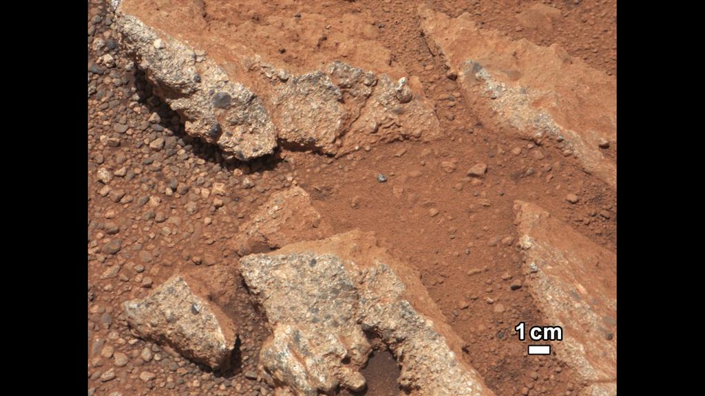
The Link outcrop images on Sol 27 using the 100mm Mastcam
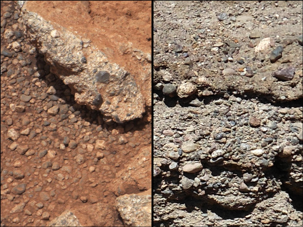
The first set of these images were of an outcrop of rock dubbed Link, and showed rounded gravel fragments, called clasts, up to a few centimetres in size within the rock outcrop. Too large to have been moved as a result of wind action, these clasts have been deemed to be consistent with a sedimentary conglomerate, or a rock that was formed by the deposition of water and is composed of many smaller rounded rocks cemented together.
A close-up of Link (l) compared with similar rocks seen on Earth (r). Erosion of the outcrop on Mars has resulted in gravel clasts which have fallen onto the ground, creating the gravel pile. The outcrop characteristics are consistent with a sedimentary conglomerate, or a rock that was formed by the deposition of water
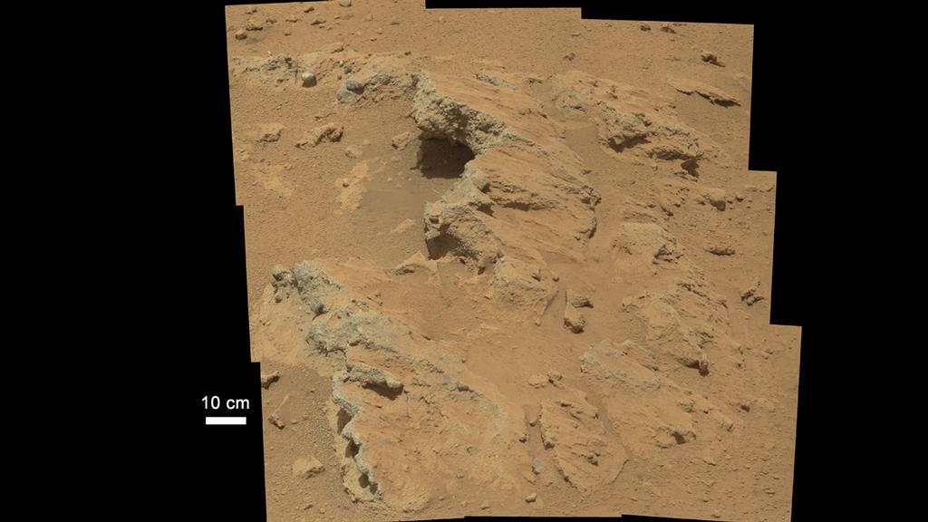
On Sol 39, Curiosity imaged a more remarkable outcrop, dubbed Hottah after Hottah Lake in Canada’s Northwest Territories. The exposed bedrock in the images, again captured with the 100mm Mastcam, is made up of smaller fragments cemented together to again form sedimentary conglomerate.
The location of the stream bed lies between the north rim of Gale Crater and the base of “Mount Sharp”, the mound towards the centre of the crater which Curiosity will explore later in the mission. Imaging of the region from orbit shows an alluvial fan of material washed down from the rim, streaked by many apparent channels, sitting uphill of the new finds, further evidence that water was once free-flowing in the region, probably over a reasonably long period of time in Mars’ ancient past. The images of the outcrops themselves show what are referred to as “classic conglomerates”, rocks that are made up of gravels and sand which have been cemented together. The sizes and shapes of stones offer clues to the speed and distance of the ancient stream’s flow.
“From the size of gravels it carried, we can interpret the water was moving about 3 feet [1 metre] per second, with a depth somewhere between ankle and hip deep,” William Deitrich, an MSL science co-investigator said, reviewing the images.
The Hottah outcropping of bedrock – evidence of an ancient stream bed imaged by Curiosity
Use the page numbers below left to continue reading this article
The SunAeon team have been working on the primary site, and adding a raft of new features, which launched on Wednesday 26th September. Once again, I was very honoured to be asked to contribute to the site, providing information on the Earth, the Moon, the Sun and little Pluto.
Launching SunAeon presents you with a new introductory video, a virtual tour of the Sun, the eight planets and Pluto, showing each in turn, together with notable surface features in the case of the Earth, the Moon and the Sun, and cutaway views of the interiors of the major planets.
The main screen navigation tools remain unchanged, although the Navigate drop-down menu (accessed from the SunAeon button, top left of the screen), now includes the Sun, Earth, Moon and Pluto. Clicking on any of these will take you to your topic of interest and present the familiar surface view of the target, and the data display options.
Data Display for the Sun
The amount of information available for each target is currently a little variable – Earth and the Sun, for example, have a lot more data options available for them, including panels for their atmospheres as well as internal structures (blame me for that – I may have overloaded Mito and the team with text!). Surface features are also now annotated for them, and for the Moon, allowing specific points / features to be focused upon and dedicated information panels displayed for them. I confess I wasn’t involved in these panels, but now I’ve seen them, I hope very much that Mito and the team will include a similar approach for the other planets as well – such as coverage of Olympus Mons, Gale Crater, Gusev Crater, the Vallis Marineris on Mars; Jupiter’s Great Red Spot, and so on.
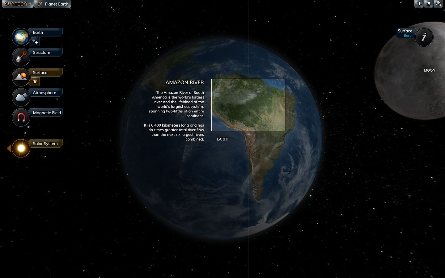
An additional surface features pop-up panel for Earth
Some of the planetary data display pages now also include videos, provided courtesy of NASA. The pages for the Sun, the Moon and Mars all now incorporate optional videos, one of which features the upcoming MAVEN mission to study the upper atmosphere of Mars, and which is scheduled for launch at the end of 2013.
Ace of Space
This update also includes a very simple game as well. Called Ace of Space, This is essentially racing a small spaceship around the eight planets of the solar system, passing just close enough to each to make a checkpoint. The race is against the clock, and planets can be tackled in any order (although there is a degree of planetary alignment which can be used if you hit on the right course). Controls are simple – the arrow keys, with UP firing your main engines and DOWN firing your retro motors (both burning your fuel allowance, which can be renewed), and LEFT and RIGHT turning your ship. For those that feel up to it, you can also activate the planets’ gravity wells, which you can use to assist your flight – as long as you’re careful!
Flying past Mars in Ace of Space
Ace of Space is lighthearted fun, and includes a “free flight” mode. It’s hopefully a sign of more sophisticated space flight / exploratory capabilities will be added to SunAeon as time goes on, in accordance with the original roadmap for the site. The game can also be downloaded, for those who prefer to play it directly on their desktop / laptop, and the code is available to embed into webpages as well. If I have any critique at all, it is that the only way to get back to the main SunAeon solar system model appear to be going via the HELP option in the game or clicking the BACK button on your browser – an on-screen option would make things easier.
This is another nice update to SunAeon, and I’m again honoured in being asked to assist with a small part of it. I’m now looking forward to seeing it grow to include more details on the planets, moons and other bodies in our solar system.
Over the course of the last month, Kitely, the on-demand virtual world service, has continued to refine their megaregion offering introduced at the start of August, improving their OpenSim performance in the process. They’ve also announced an upcoming feature called “Transfer stations”.
Traditionally, working with megaregions is limited in some ways due to the viewer code being geared towards handling regions which are 256×256 metres in size. Editing terrain textures, for example, is something which usually cannot be done when working on a megaregion. While megaregion mode can be disabled to allow work to be carried out on a per-region basis, it can also lead to problems: landmarks can stop working, in-world objects may show at the correct location, etc.
Kitely have solved this problem by introducing an Advanced Megaregion option, which works relatively seamlessly with the viewer. When a world owner / manager using a megaregion attempts to carry out an operation such as changing the terrain settings, a pop-up is displayed advising them that the operation cannot be performed with the world running in Advanced Megaregion mode. A link on the pop-up allows the world owner to switch to their browser and disable the Advanced Megaregion option via their Manage World webpage. This then allows them to work on the world as if it were a series of individual regions. Once terrain work has finished, the Advanced Megaregion mode can be turned on once more.
The Advanced Megaregion also allows parcel media to be heard right across a megaregion (rather than being limited to the south-west corner region).
“Oren, We Need Warp Speed!”
As well as working on megaregions, Kitely has been optimising the OpenSim code running on their cloud-based servers. In the same blog post announcing the Advanced Megaregions, Oren Hurvitz, Kitely’s co-founder and VP of R&D describes the improvements thus:
We have made numerous improvements to OpenSim to make big worlds work faster on Kitely. These changes reduce OpenSim’s CPU usage up to 80%! This makes the user experience smoother and allows for the use of more complex worlds and more avatars than regular OpenSim. The following chart shows how much we reduced CPU usage compared to regular OpenSim. These tests were done on a world running in its own server, with one avatar in the world.
Kitely CPU server optimisation (courtesy Kitely)
This optimisation allows Advanced Megaregions on Kitely to run up to 5% faster than regular megaregions.
Transfer Stations
Transfer Stations are an upcoming Kitely feature. They are described as, “Miniature worlds that users wait in while their world is being loaded.” The blog post announcing them goes on:
Kitely is a cloud-based virtual world provider, so when a user tries to enter a world that is currently offline we need to start the world first. This is fairly quick, but not instantaneous. Currently users look at a progress bar on our website while the world is being started, and once the world is ready their viewer is automatically launched. Transfer Stations are going to change this: when a user tries to enter an offline world their viewer will start immediately, but they will enter a Transfer Station instead of the desired world. Once the world is ready the user will be teleported to it automatically.
The Transfer Stations will be located on dedicated worlds specifically set-up for them, and could, in the case where more than one user is logging-in to the same offline world, allow people to meet and chat while awaiting their destination to load (not that the wait should in any way be extensive!).
To encourage the development of Transfer Stations, Kitely are inviting world owners to submit themed Transfer Station designs of their own, which other world owners and managers will then be able to pick from when setting-up a Transfer Station on their world(s).
Kitely Transfer Station conceptual drawing (courtesy Kitely)
There are certain requirements which must be met for Transfer Station submissions, and these can be found in the Kitely blog post. Reviews of submissions, which will be performed by the Kitely Mentor’s Group, will commence on October 1st.
New Avatars
On September 21st, Kitely updated their default avatars with a range of seven new avatars, using modified assets based on ones provided by designer Linda Kellie. The avatars are available to new users signing-up to Kitely, and the assets are currently also available at in-world Linda Kellie malls for those who wish to use them as their base model.
Kitely’s new default avatars (image courtesy of Kitely) – click to enlarge
Over the course of the last week Curiosity has been busy. Sols 39 through 41 (September 14th through 17th) were driving days in which the rover continued on its traverse towards the area dubbed Glenelg. On Sol 39, Curiosity logged 22 metres (72 feet), and covered a further 37 metres (121 feet) on Sol 40.
Sol 41 saw the rover cover 27 metres (89 feet), during which the Dynamic Albedo of Neutrons (DAN) instrument was incorporated into the rover’s drive sequence. In its active mode, DAN can detect sub-surface minerals associated with water. The instrument has a high sensitivity for finding any hydrogen to a depth of about 50 cm (20 inches) directly beneath the rover. Use of the DAN experiment requires the rover to travel 10 metres (33 feet) before stopping to operate the DAN instrument for 2 minutes, then rolling forward another 10 metres and again operating the DAN instrument, and so on.
On Sol 42, Curiosity travelled a further 32 metres (105 ft), bringing the mission’s total driving distance to about 259 metres (850 ft), reaching the half-way point in the drive to Glenelg. DAN was used at two stops during the drive to check for hydrogen in the soil beneath the rover. During the drive, the rover also paused to take further images of both Phobos and Deimos as they passed in front of the Sun.
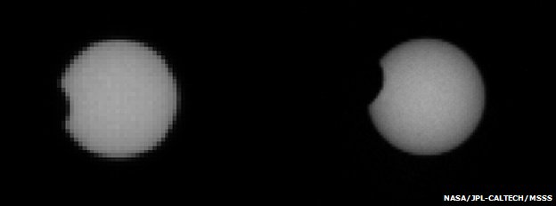
Transit of Phobos: had Curiosity been at the top of “Mount Sharp”, this would have been an annular eclipse; Phobos would have been entirely within the disk of the Sun (images from Sol 37 Phobos transit)
Imaging these transits provides accurate data on the orbits of the two moons; although both Phobos and Deimos are very small objects compared with the planet, they still exert a tidal influence on Mars. Having accurate information on their orbits assists scientists in understanding how this tidal influence affects Mars, giving additional clues as to its internal structure. Similarly, the data can also be used in helping to understand the internal structures of the two moons. In addition, measuring the orbits of the two tiny moons helps scientist determine the rate of decay within Phobos’ orbit (Phobos is very gradually slowing down in its orbit and will, at some point in the distant future, break-up and fall onto Mars), and the rate at which Deimos is accelerating in its orbit.
Because so much information can be gathered that can help scientists gain greater insight into Mars and its moons, observing transits by both Phobos and Deimos have previously been a regular activity for NASA’s MER rovers. In fact, Opportunity (as the one remaining operational MER vehicle on Mars) conducted transit observations from its location almost in parallel with Curiosity.
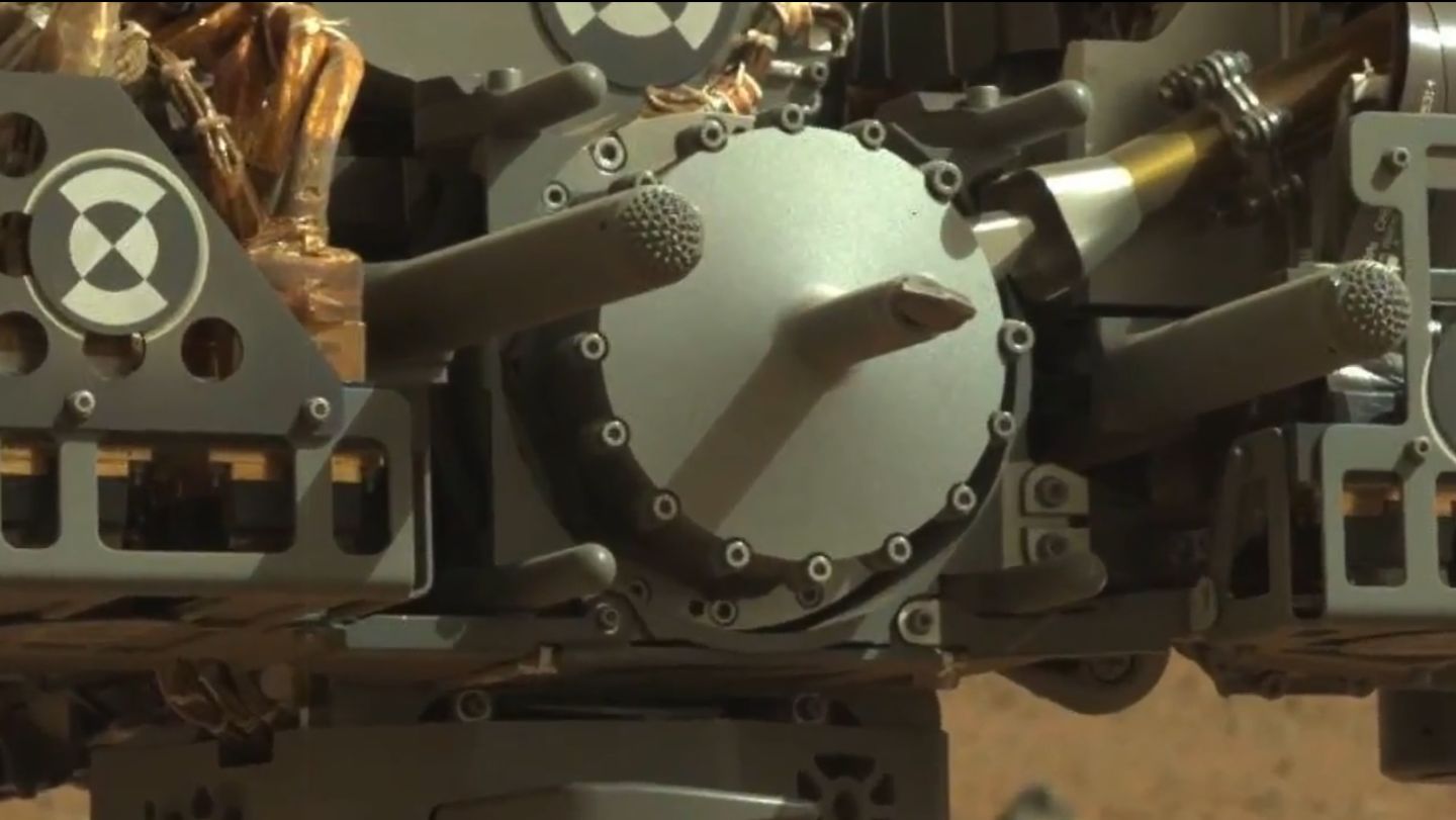
On Sol 43, an unusual rock was identified as a potential target for further tests of the rover’s arm-mounted science instruments – particularly MAHLI, the Mars Hand Lens Imager and APXS, the Alpha Particle X-Ray Spectrometer. During something of an abbreviated day due to the timing of downlink relays on Sol 44, Curiosity took a more detailed look at this rock, as well as observing the early morning atmospheric conditions in Gale Crater and capturing additional images of the instruments mounted on the turret of the robot arm.
A close-in view of the sample acquisition system mounted on the turret at the end of the robot arm
The target rock, roughly the size of a football, was christened Jake Matijevic, in honour of Jacob Matijevic, MSL’s Surface Team Chief Engineer, who passed away shortly after Curiosity arrived on Mars. Matijevic had worked on all three generations of NASA’s Mars rovers, from the tiny Sojourner-class mini-rovers of the 1990s, through the MERs to Curiosity.
Jacob Matijevic, 1947-2012
Please use the page numbers below left to continue reading
Rollin’, rollin’, rollin,
Though the plains are dusty
Keep that rover movin’
NASA. Rocks and wind and cold nights Crossing that ol’ crater On your way to Glenelg now, in style. All things you’re doin’, Sampling, scraping, dating Will help our understanding of Mars.
(With apologies to Ned Washington!)
Over the course of the last several days, NASA has completed initial calibration and characterisation of Curiosity’s robot arm and initial testing of several of the turret-mounted scientific instruments.
These tests have included discovering the arm’s range and accuracy of movement in the low Martian gravity and temperature environs, as well as commissioning the turret-mounted Mars Hand Lens Imager (MAHLI) camera and the Alpha Particle X-Ray Spectrometer (APXS) which is designed to determine the elemental composition of a target rock. Both are now all but cleared for science operations, although some further tests are planned.
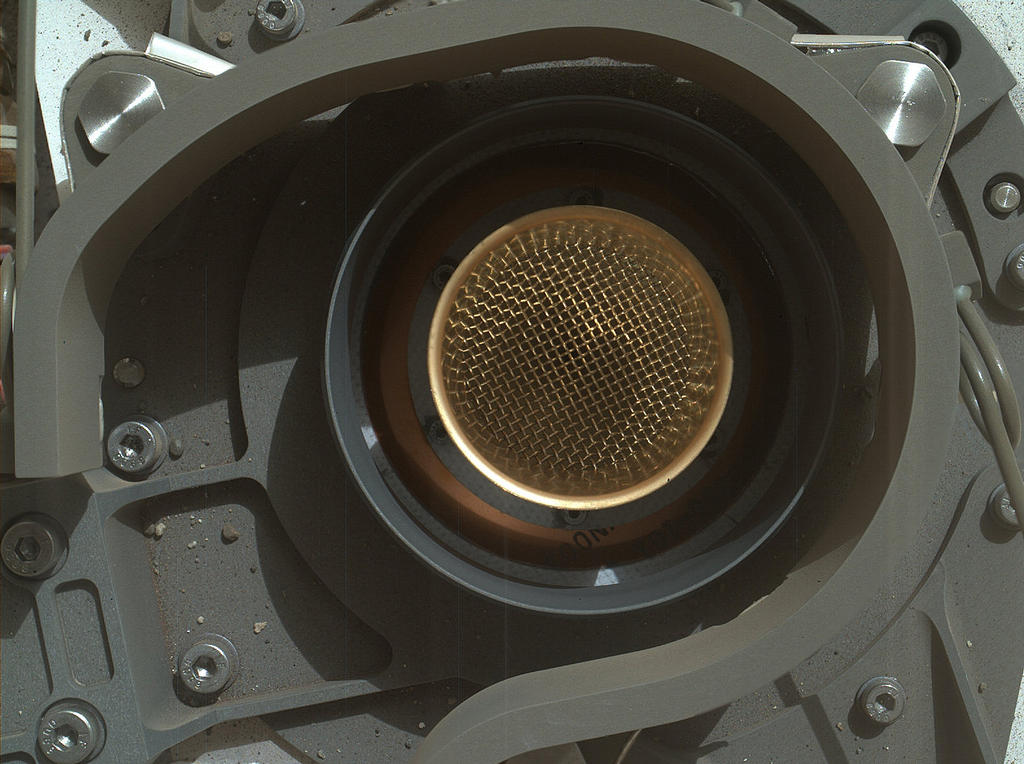
On September 11th, Sol 36, the arm went through a series of “reach tests” using MAHLI to ensure that the arm can accurately position equipment over inlet ports on the rover’s body for the transfer of materials gathered from the surface of Mars.
Open wide! The CheMin sample inlet port, imaged by MAHLI on Sol 36. The 3.5cm (1.4 in) diameter mesh-covered funnel will be used to supply Martian “fines” to the CheMin spectrometers for analysis
The Canadian-made APXS has previously been used to gather atmospheric readings, but the tests performed on September 10th, Sol 35, marked its first use on a solid target, using a calibration target mounted on the rover. The results showed APXS to be in excellent health. “The spectrum peaks are so narrow, we’re getting excellent resolution, just as good as we saw in tests on Earth under ideal conditions,” Ralf Gellert, the principal investigator for APXS reported. “The good news is that we can now make high-resolution measurements even at high noon to support quick decisions about whether a sample is worthwhile for further investigations.” This latter point is important, as X-ray detectors best work cold, and so was thought that APXS might find the midday periods of a Martian Sol a little too warm to produce reliable results.
APXS imaged by the 34mm Navcam on Sol 32 (September 7th), during initial visual check-outs of the arm and turret systems. This image confirmed APXS was not caked with dust blown up by the Descent Stage motors during Curiosity’s arrival on Mars.
After its initial check-outs, MAHLI was further tested in its ability to produce 3D images of surface objects, again using the calibration target mounted on the front of the rover. MAHLI is the second imaging system Curiosity carries that is capable of producing colour 3D images, the other being the Mastcam system, which was tested prior to the rover departing Bradbury Landing. Both systems produce 3D images through accurate positioning of the cameras, either by manoeuvring the robot arm (for MAHLI) or the entire rover (for Mastcam).
Transit of Phobos
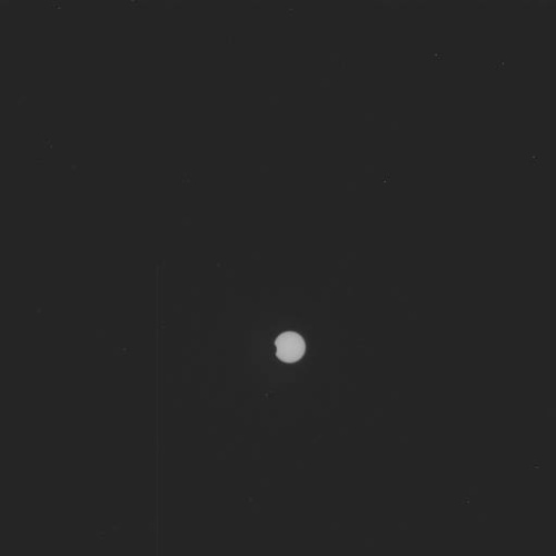
Earlier this year, I covered the Transit of Venus, an astronomical event only visible from Earth every 105 or 121 years. Mars has similar events, which include transits of the Earth across the face of the Sun and, more particularly, transits of its own small moons, Phobos and Deimos. Transits of Phobos occur twice every Martian year, and on Sol 37 (September 12th), Curiosity’s Mastcam was used to capture images of a Phobos transit. The full-resolution images from this are liable to take a few days to download and be processed, but the plan is to produce a movie of the transit from the images captured.
A raw (unprocessed) low-resolution image of the transit of Phobos – the 11km wide moon, some 6,000km above the surface of the planet can just be seen on the edge of the solar disk
Next Stop: Glenelg – or a rock
With the arm characterisation tests now all but complete, Curiosity was ordered to resume its drive towards Glenelg, an area of Gale Crater some 400 metres from Bradbury Landing. The drive commenced on Sol 38 (September 13th), when the rover completed a drive of 32 metres, a further increment in the daily distance covered as confidence is gained in Curiosity’s autonomous driving capabilities. Even so, it will still be another few weeks before the rover arrives at Glenelg, and the drive may again be interrupted if a suitable rock candidate is identified for direct in situ testing of APXS and MAHLI. If deemed suitable, the rock may also be used to test the rover’s turret-mounted drill, although testing of this may be held-over until Glenelg is reached towards the middle of October.
David Oh from the MSL team provides a superb summary for the week, and insight into working as a part of the Curiosity team.
September 7th through 9th saw the robot arm systems go through a range of “reach tests” which also allowed Curiosity it complete another series of “firsts” from Mars as the Mars Hand Lens Imager (MAHLI) was used to capture a range of images of the rover to help with calibrating the system and to check-out Curiosity’s condition. All of these images were taken with the protective cover on MAHLI’s lens in the open position, and revealed the clarity with which the system can capture images.
There was a slight delay in progress on Sol 31 (Sept 6th), after a temperature reading from the arm caused Earthside concerns and the cancellation of planned activities while the matter was investigated and successfully resolved. Sol 32 (Sept 7th) saw the tests planned for the 6th Sept successfully completed, which included the capture of the images of the rover’s mast and the turret on the end of the robot arm I’ve previously reproduced here. A series of vibration tests were also carried out, designed to characterise the function of the sample processing device in the turret (the vibrations will cause the system to act like a sieve, separating-out very fine Martian surface material out from the rougher samples prior to delivery to the on-board science systems, CheMin and SAM).
The reach tests for the robot arm are designed to test the arm based on a range of calibration motions carried out on Earth intended to approximate how the arm should work on Mars. The tests are important because the arm, with the mass of the turret on the end, has only been operated in Earth’s gravity and engineers need to confirm that the arm is actually functioning as anticipated in the lower Martian gravity environment and after both an 8-month cruise through interplanetary space and the rough dynamics of the EDL phase of the mission. Adjustments carried out as a result of the reach tests will allow the arm and turret to be operated with the degree of precision required for the forthcoming science elements of the mission.
The Trivia Report I Forgot
On some of these MSL reports, I’ve published a small piece of trivia about the mission. One that I had lined-up, but then missed Pressing, was that fact that among all the science hardware on Curiosity there is … a 1909 Lincoln VOB penny.
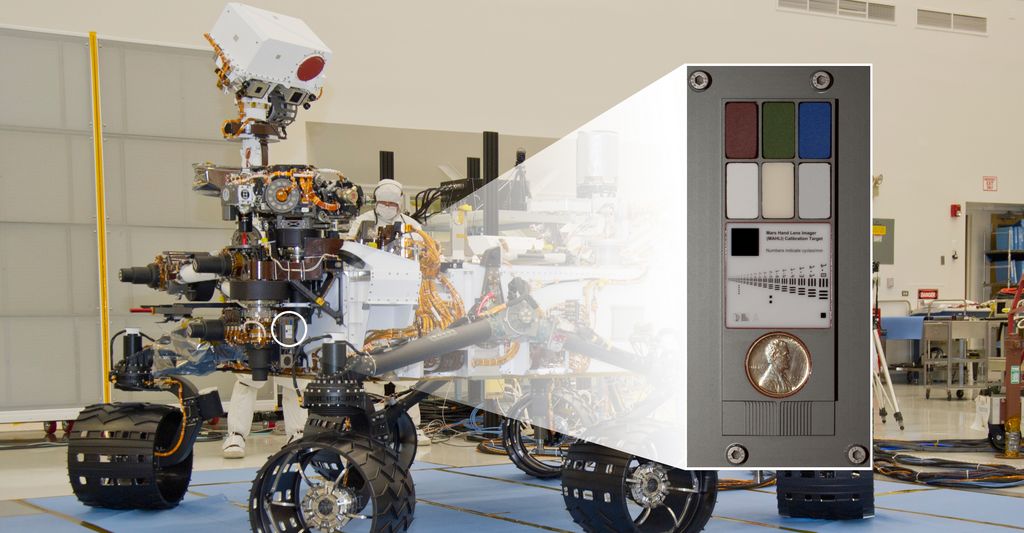
MAHLI calibration target, complete with the first coin on Mars, a 1909 Lincoln penny
The penny is part of the calibration target for MAHLI, which is mounted on the front of the rover’s body. The target also includes colour chips, a metric standardised bar graphic, and (just below the penny) a stair-step pattern for depth calibration.
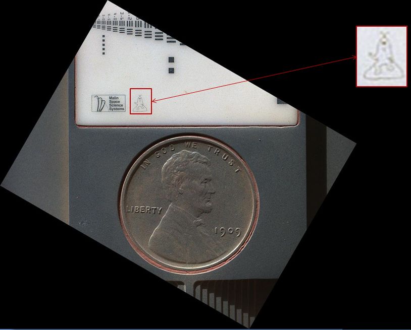
The penny itself is a nod to geologists’ tradition of placing a coin or other object of known scale as a size reference in close-up photographs of rocks, and it gives the public a familiar object for perceiving size easily when it will be viewed by MAHLI on Mars. The coin was supplied by MAHLI’s principal investigator, Ken Edgett, and was minted to mark the centennial of Abraham Lincoln’s birth.
The Lincoln penny seen on Mars by MAHLI; note the fine film of Martian dust on the coin. “Joe the Martian” can be seen above the penny & inset. The main image was captured with MAHLI some 5cm (2 inches) from the target, and on a low resolution setting
Also on the calibration target is an image of “Joe the Martian”. This is also from Ken Edgett, and is actually his own creation, first drawn when he was nine years old when the NASA Viking missions in the 1970s inspired him to want to become a planetary researcher. The character was later used in a children’s science periodical, Red Planet Connection when Edgett directed the Mars outreach program at Arizona State University in the 1990s.
Both the penny and the character are designed to engage public interest in the mission, and both will be imaged throughout Curiosity’s operations on Mars, allowing people to see how weathered they become over time due to exposure to the Martian environment.
Taking a Look Underneath
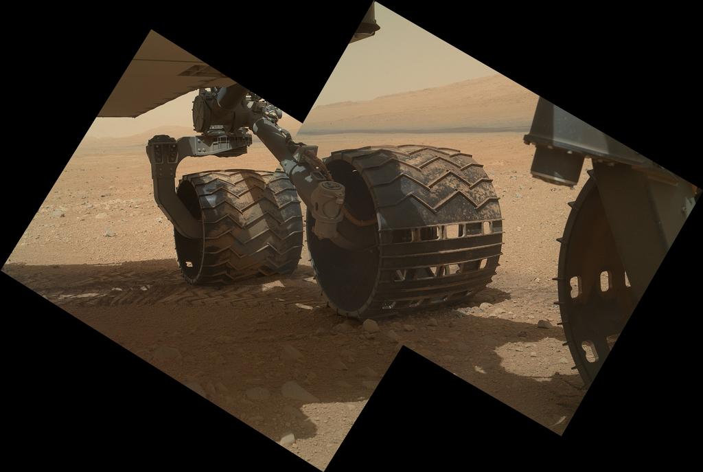
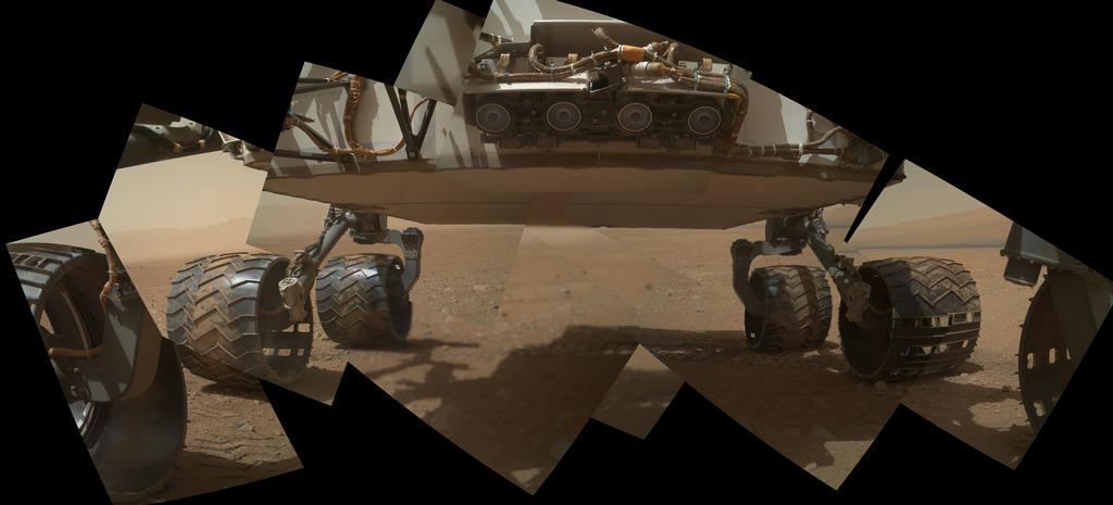
On Sol 34 (Sept 9) MAHLI was used to take a series of images looking underneath the rover’s belly, allowing engineers to take a first-hand look at the overall condition of the wheels and underside of the vehicle and confirm there is no hidden damage which might cause problems later.
Curiosity’s wheels – note the Morse code JPL cut-outs – with “Mount Sharp” as a backdrop
These images also help demonstrate the extreme flexibility of MAHLI, which can image objects from as close as 2.1 cm (just under an inch) right out to infinity, allowing it to be used for close-in precise work related to surface science, and for producing more general images which can be used in a range of activities from confirming the rover’s status through to helping to plan for the drive to “Mount Sharp”.
Taken together, the MAHLI images are remarkable because no other planetary or robotic mission has been able to image itself so comprehensively. Being able to do so not only assists engineers in assessing the rover’s condition throughout the mission, it helps to further engage public interest in what Curiosity is doing by “personalising” the images it can return from Mars.
MAHLI mosaic of Curiosity’s underside. The four “eyes” at the top centre are the rover’s forward Hazcams, used in vehicle navigation, looking to the front and to the left / right of the rover’s path
 NASA has released images returned to Earth by the Curiosity rover of what appears to be an ancient stream bed, together with images showing further evidence of liquid water once having flowed freely within Gale Crater.