One kilometre and counting

CuriosityOn July 16th, NASA’s Mars Science Laboratory rover Curiosity passed the one kilometre mark (0.62 miles) on its travels around Gale Crater. The milestone came eleven months after the one-tonne rover arrived on the surface of Mars on August 5th 2012.

Since that time, Curiosity has achieved a lot; it has travelled across several terrain types, it has studied the Martian atmosphere and meteorology and probed the ground underneath it for evidence of water. It has taken samples from the surface of Mars and drilled into rocks. It has analysed samples and returned a huge amount of data to Earth, including thousands of colour, black and white and high-resolution images. It has viewed its surrounding in 3D and – most intriguing of all – it has discovered very convincing evidence that Mars was more than likely once an abode suitable for the evolution of basic life.

Coincidentally, July 17th 2013 marked the half-way point for the rover’s prime mission of one Martian year (687 day or 1.88 Earth years). As the rover’s power system has a potential operating life of fourteen years, it is more than certain that, barring any accidents or major systems failure in the interim, operations will be extended well beyond the prime mission time frame. In this, Curiosity will not be alone; half a world away, NASA’s rarely mentioned Opportunity rover is fast approaching the tenth anniversary of what was originally a 90 day mission.
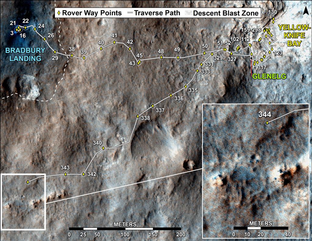
Curiosity’s progress: from landing through to its position on Sol 344 (July 24th, 2013) The numbered dots along the line indicate the Sol number of each drive. North is up. The scale bar is 200m (656 ft). From Sol 343 to Sol 344  Curiosity drove a straight line distance of about 68.82m (225.79 ft)

More Atmospheric Analysis

As mentioned above, Curiosity has been studying the Martian atmosphere using the Sample Analysis at Mars (SAM) suite of instruments. SAM has more recently been involved in analysing rock and soil samples collected by the rover’s scoop and drilling system, so it is easy to forget that it can also “sniff” and analyse Martian air, which it did for the very first time right back at the start of the mission. Since then, SAM has continued to periodically sample the Martian atmosphere, and it has already helped in further understanding the dynamics of the atmosphere and how it may have been lost over time.

SAM is able to measure the abundances of different gases and different isotopes in the Martian atmosphere. Isotopes are variants of the same chemical element with different atomic weights due to having different numbers of neutrons. In the first set of tests carried out, SAM compared the stable isotope argon-36 with its heavier cousin, argon-38. Since then, SAM has carried out a series of comparative tests on a range of isotope drawn from the Martian atmosphere, including carbon-12 and carbon-13 and both oxygen and hydrogen isotopes.

These tests, carried out using two different instruments within SAM – the mass spectrometer and tuneable laser spectrometer – during the first 16 weeks of the mission, measured virtually identical ratios of carbon-13 to carbon-12, with the ratios again pointing to the lighter isotopes having “bled off” into space from the upper portions of Mars’ atmosphere, rather than a process of the lower atmosphere interacting with the ground.

“Getting the same result with two very different techniques increased our confidence that there’s no unknown systematic error underlying the measurements,” said Chris Webster of NASA’s Jet Propulsion Laboratory. “The accuracy in these new measurements improves the basis for understanding the atmosphere’s history.”

The rate at which Mars is currently losing its atmosphere cannot be measured by Curiosity or any of the vehicles currently operating in orbit around Mars.  This will be the work of the Mars Atmosphere and Volatile Evolution (MAVEN) mission, which is due to be launched in November 2013.

Gullies on Mars: Water or Dry Ice?

While it is accepted that Mars’ atmosphere was once dense enough to support liquid water – Curiosity itself has found unmistakable evidence for free-flowing water to have once been present in the crater – evidence has also put forward to suggest that some features imaged on Mars and associated with possible water action may have been the result of another process entirely, as explained in this interesting NASA video.

Continue reading “One kilometre and counting” →

InWorldz second Relay for Life season announced

IW RFLThe Second annual Relay for Life of InWorldz (RFL of IW) season has been formally announced.

InWorldz held its first Relay For Life (RFL) season, fully sanctioned by the American Cancer Society, in 2012, raising some $15,000.

The 2013 season will commence in late August 2013 and run through until the start of November, culminating in the Relay itself on Saturday November 2nd.

Key Dates

The season opens on Saturday August 24th, 2013 at 09:00 InWorldz Time at Paradise by Design (IWurl).

The “half way” event will take place on Saturday September 28th, starting at 09:00 InWorldz time.

The Relay itself will be held on Saturday November 2nd, commencing at midday, InWorldz time.

Sponsorship

Sponsorships for the season are currently open, and comprise three levels, starting at $50.00 USD and rising to $150.00, each with unique benefits to sponsors, including website promotion, event mentions, logo promotions, and more. For full details of each level of sponsorship, the levels still available, and how to become a sponsor, please refer to the RFL of IW sponsorship page.

Further Information

About Relay for Life

Relay For Life (RFL) is an inspirational overnight fundraising event that honours cancer survivors and celebrates life. Each Relay is a community-led, non-athletic event where teams fundraise and then join together in the Relay event. There, teams take it in turns to walk round a track for up to 24 hours to signify that ‘cancer never sleeps’.

RFL started in the United States in 1985 when one man circled around a track for 24 hours raising $27,000. Now, over four million people from twenty countries world-wide participate annually in Relay for Life events. RFL of IW is officially sanctioned by the American Cancer Society and a recognised RFL event.

Related Links

The long trek and looking to the next decade

CuriosityCuriosity has started on the long trek to Aeolis Mons, which NASA unofficially refers to as “Mount Sharp”. With some eight kilometres (5 miles) between the rover an its initial destination among the lower slopes of the mound, the drive is liable to take several months to complete. Nevertheless, the drive marks the start of the core part of the mission.

The journey started on July 4th, when Curiosity departed the sedimentary rock target NASA had dubbed “Shaler” within the “Glenelg” region of Gale Crater between “Yellowknife Bay”, where the rover had been carrying out drilling and other tasks, and the landing zone at Bradbury Landing. “Shaler” had actually been passed b the rover on its way to “Yellowknife Bay” and had, along with another location in “Glenelg” which had been dubbed “Point Lake”, been identified as a “target of interest” for the rover as it backtracked through “Glenelg” in order to start the long trip to “Mount Sharp”.

“Point Lake” became a target of interest to MSL scientists as Curiosity passed it while en route to “Yellowknife Bay”, and remained of interest even as the rover carried out various science operations in “Yellowknife Bay”. This image was captured by the Mastcam telephoto lens on  Sol193 (February 20th, 2013) when Curiosity was engaged in the “John Klein” rock drilling operations. It show the cliff-like face of the outcrop. At the time the image was captured, it was unclear if the outcrop might be sedimentary or volcanic in origin. This image has been white-balanced so the rocks appear as they would under Earth-type atmospheric and lighting conditions

Point Lake first caught the interest of Curiosity’s science team in October and November of 2012. It caught the attention of mission scientists for two reasons: it forms a small cliff, and geologists love cliffs because they offer a sense of how a rock unit differs from bottom to top; plus images captured by the rover as it passed relatively close to the outcrop while en route to “Yellowknife Bay” revealed it to be full of holes. Why holes form in rocks can be due to diverse mechanisms, and Identifying which mechanism in particular is responsible can provide a greater understanding about the rock and its history.

The rover returned to “Point Lake” on Sol 301 / 302 (June 11th and 12th, 2013) and captured a further series of images using the Mastcam systems, some of which were then put together to create a mosaic.

A 20-shot mosaic of “Point Lake” captured by the telephoto lens of Curiosity’s Mastcam system on Sol 302 (June 12th, 2013) (click to see the full size image)

The mosaic clearly shows that the upper and lower portions of the outcrop differ in composition, with the upper part having more holes while being more resistant to weathering. The holes themselves range in size from about that of a garden pea through to some larger than a golf ball’s diameter. Some additionally have raised rims, as if the material immediately around a hole is slightly more resistant than material farther from the hole. A number of smaller rock fragments towards the right-hand end of the mosaic look as if they might have fallen out of some of the holes, and some of these exhibit colour banding suggestive of material which could have coated the interior of a hole.

The science tem are still studying the images captured by the Mastcam system and by the rover’s Mars Hand Lens Imager (MAHLI), mounted on the turret at the end of Curiosity’s robot arm. Taken from a distance of just 4cm, the MAHLI images reveal pebble-like deposits within many of the holes covering “Point Lake”, and which have made the identification of the processes responsible for forming the holes somewhat harder, as both sedimentary and igneous processes could account for the “pebbles”.

The Mars Hand Lens Imager (MAHLI) mounted on Curiosity’s robot arm captured this close-up of the holes in the “Point Lake” rock outcrop, in which the “pebbles” cxan be seen to be nestling

Following the stop at “Point Lake”, Curiosity continued retracing its route back through “Glenelg”, reaching the vicinity of “Shaler” around Sol 313, where it remained for several days taking further images and manoeuvring in the area immediately adjacent to the rock formation. Then on July 4th, the rover started on the drive to “Mount Sharp” in earnest, initially travelling  back towards “Rocknest”, which it visited in September 2012, prior to skirting around it in a drive of some 36 metres (118 feet) between July 5th and July 8th (Sol 327).

Continue reading “The long trek and looking to the next decade” →

Mesh deformer: moving ahead in InWorldz, but will it affect LL?

At the weekend, Tranquility Dexler, the CTO of InWorldz,  Tweeted about the work Qarl Fizz (Karl Stiefvater) has been undertaking in order to implement the deformer for InWorldz, and the fact that Qarl has a patch which should enable TPVs to integrate the”fast deformer” into their code.

Tranquility Dexler's Tweet from July 6th
Tranquility Dexler’s Tweet from July 6th

The link in the Tweet leads to a post on Qarl’s blog which gives further information on the project:

The team over at InWorldz recently asked if i could help them integrate the clothing deformer into their new mesh viewer. which is nice, I think, because people really want to fit their clothing. and so far they can’t.

But the InWorldz guys took it a step further – they asked if there was anything I could do to improve the code. and I said yes, it could be made faster. and they put-up a bit of money to make it happen.

Attached is a patch to the deformer code which (by my quick estimates) makes the deformation process 21 times faster. many thanks to David and McCabe for making this possible.

Qarl: working ti integrate the deformer code into the InWorldz viewer

This has led to some speculation as to what impact the patch might have on the Lab’s work with the deformer.

I would hazard a guess and say, “Initially, not a lot.”

I say this not to denigrate LL or to suggest that LL have no interest in implementing the deformer.

Rather, I say it simply because the Lab will likely proceed at their own pace as and when the resources are available to focus on the work they have – as a result of the many and varied robust discussions held on STORM-1716  – determined as needing to be carried out before they move the deformer to a released status.

This does, however, leave TPVs with a dilemma. Do they push ahead and adopt the code, and risk issues down the road when LL start to update the deformer themselves while opting to ignore Qarl’s latest work? Or do they play safe and wait to see what the Lab opts to do?

There is some speculation that were TPVs to incorporate the code into alpha / experimental versions of their viewers, it might tip the balance towards the Lab renewing work on the deformer (and / or adopting them code) sooner rather than later. However, there is a question mark over this.

While TPVs can produce “experimental” viewers utilising code which “breaks” the “shared experience”, it has always been intimated by the Lab that they can do so only as long as such viewers don’t enter into widespread use. While it isn’t easy to determine how LL would police this in practice (block a given viewer string? Issue a warning notice? Something else?), it might deter some TPVs with larger communities from making the code available except under very controlled conditions. If so, this might serve to dramatically reduce the visibility of a “working” deformer and possibly leave the Lab free to sail its own course.

Another option for TPVs – at least those who support OpenSim – is to integrate the code into their OpenSim versions. If nothing else, adoption of the code into OpenSim versions of various viewers might in turn see a more widespread use of mesh clothing on OpenSim, something entirely in keep with the initial goals of the project.

Posting on STORM-1716, Henri Beauchamp has already indicated he’ll be taking both routes: all three branches of his Cool VL viewer will incorporate the new code but only the experimental branch will use it when connected to SL; his legacy and stable branches of the viewer will only use the code when connected to OpenSim.

In the meantime – and again, absolutely no slight towards Linden Lab – kudos to the folk over at InWorldz for moving to adopt the deformer.

Related Links

My thanks to Tranquility Dexler for the Tweet, which alerted me to the work, and to Shug Maitland, for poking me to blog about it.

One billion pixels, two remarkable images

CuriosityThe news coming out of NASA about the Mars Science Laboratory has slowed somewhat following the period of solar conjunction which formed a natural break in operations during April.

As I’ve mentioned before, there is nothing surprising in this – the news operates in cycles, and NASA is only too aware that trying to keep Curiosity as a headline item isn’t going to stick. Better than to keep the mission going at both ends of the divide – Earth and Mars – as report to the media when there is significant news to report.

And it is fair to say that mission personnel have a lot of data to analyse. Not only are there the results of the recent sample gathering from the “Cumberland” rock to comb through, there is still a wealth of data covering the rover’s first ten months on Mars which is growing daily as a part of its automatic monitoring of its environment as well as all the data gathered during the flight from Earth to Mars which has already renewed concerns about the long-term health of humans attempting a mission to Mars, as I reported last time around.

In the meantime, Curiosity’s extraordinary ability to capture images and video of the surface of Mars has come in for attention.

The primary reason for this the release of the “billion pixel image” of the “Rocknest” region of Gale Crater, where Curiosity spent some time in 2012 after departing its landing site at Bradbury Landing, and was the location where the rover’s scoop was first tested and samples of Martian soil were first analysed by the rover.

Actually comprising some 1.3 billion pixels, the image brings together over 900 images primarily captured by the rover’s Mastcam telephoto lens (some 850 in all), although some wide-angle shots from the second Mastcam lens (21) are also included, as are 25 frames captured by the mast-mounted black-and-white Navcams. Together, the images form a full-circle view of Gale Crater as seen from “Rocknest”, providing a unique insight into the environment.

Curiosity's remote sensing mast, seen fully deployed prior to launch in 2011
The top of Curiosity’s mast, highlighting the colour Mastcam lenses and the black-and-white Navcam lenses

The finished product has been made available on a NASA website in two formats, both of which allow you to study the surface of Mars, panning and zooming freely, or using a selection of pre-selected images to quick zoom in on features of interest. The two versions of the mosaic can be found as follows:

Of the two, the cylindrical view is potentially the more engrossing, offering a greater number of images for zooming-in on surface features as well as a an easier means of panning and zooming freehand.

Continue reading “One billion pixels, two remarkable images” →

Getting set for a long drive

CuriosityAfter six months in “Yellowknife Bay”, Curiosity is getting ready to move on. Investigations in the area are due to come to an end in the near future, and with the new autonomous driving software now installed in the rover, it is anticipated that the long drive to “Mount Sharp” will begin very soon. The start of this phase of the mission will be marked by the Rover retracing its steps (tracks?) through “Glenelg”, the region so-named partially because it is a palindrome, reflecting the fact the rover would be driving through it twice.

How long the rover will take to get to “Mount Sharp” is entirely open to question, however. While Curiosity is now far more capable of autonomous navigation, it won’t be a case of “pick and route which looks good and go”. If nothing else, there is no way of knowing what the rover might discover while en route.

“We don’t know when we’ll get to Mount Sharp,” Mars Science Laboratory Project Manager Jim Erickson said at the Jet Propulsion Laboratory in Pasadena, California. “This truly is a mission of exploration, so just because our end goal is Mount Sharp doesn’t mean we’re not going to investigate interesting features along the way.”

The slopes of "Mount Sharp"
The slopes of “Mount Sharp” showing a “region of interest”  captured by Curiosity’s Mastcam in August 2012 while the rover was still at the “Bradbury Landing” site. Scientists are keen to explore the mesa-like outcrops on the side of the mound, although how long it will take the rover to get to them in subject to finding a suitable route and also upon what other discoveries lay along the rover’s path. The black dot in the inset image (actually a large rock) demonstrates how the rover might look from “Bradbury Landing” were it exploring “Mount Sharp” at the time the images was captured

In May, Curiosity completed a second drilling operation to obtain samples from inside an area of bedrock called “Cumberland” within “Yellowknife Bay”, delivering them to the Chemistry and Minerology (CheMin) and Sample Analysis at Mars SAM) suites of instruments aboard the rover for detailed analysis. This work is still ongoing, and it is hoped that the result will further confirm findings obtained as a result of the first drilling operation, carried out a few metres away on a rock formation dubbed “John Klein”, and which suggested that the area once had environmental conditions favourable for microbial life.

No further drilling operations are now planned for the area, although NASA has yet to give word on the results from the initial analysis of the “Cumberland” cuttings.  Additionally, once the order is given to start the drive towards “Mount Sharp”, the rover will retain cuttings from the “Cumberland” drilling ins its sample scoop which can be delivered to CheMin and SAM for additional analysis, if required.

Both drilling operations have been important steps for the MSL mission. Not only have they been a successful test / use of the last remain major science capability on the rover (the ability to drill into rocks and obtain samples), they’ve also been an important learning situation for mission engineers. Steps which each took a day each to complete when drilling at “John Klein” could be strung together into a single sequence of commands at “Cumberland”, allowing the rover to complete a number of drilling-related tasks autonomously and in a single day.

“We used the experience and lessons from our first drilling campaign, as well as new cached sample capabilities, to do the second drill campaign far more efficiently,” said sampling activity lead Joe Melko of JPL. “In addition, we increased use of the rover’s autonomous self-protection. This allowed more activities to be strung together before the ground team had to check in on the rover.”

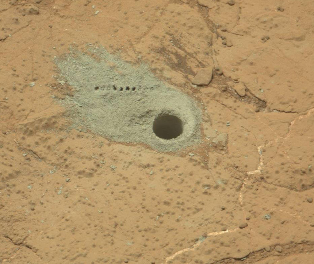
Site of the second drilling operation at “Cumberland”. The sample hole, 1.6 cm across (0.6 in) was cut on May 19th, 2013 (Sol 279). The row of small holes in the grey tailings surrounding the drill-hole mark where the Chemistry and Camera (ChemCam) laser was used to check the composition of the tailings

It’s hoped that these capabilities will allow the mission team to plan future routines for the rover more efficiently and in the knowledge that Curiosity has the ability to carry out multiple tasks without the need to “‘phone home” at each stage of an operation, something which introduces considerable delays in activities as a result of the two-way communications lag.

Prior to leaving “Yellowknife Bay”, two further “targets of opportunity” will be subject to brief observations by Curiosity. The first of these is a layered outcrop dubbed “Shaler”, which was briefly looked at as the rover initially entered the “Glenelg” / “Yellowknife Bay” region, and a pitted outcrop called “Point Lake”

The science team has chosen three targets for brief observations before Curiosity leaves the Glenelg area: the boundary between bedrock areas of mudstone and sandstone, a layered outcrop called “Shaler”, a possible river deposit, and a pitted outcrop called “Point Lake”, a depressional area thought to be either volcanic or sedimentary in nature, and which the rover observed when entering “Yellowknife Bay” from “Glenelg”.

Continue reading “Getting set for a long drive” →