Curiosity, the NASA rover carrying the Mars Science Laboratory is continuing towards its rendezvous with the foothills of “Mount Sharp” (Aeolis Mons) in Gale Crater, Mars. As such, there is little coming out of NASA in terms of updates on progress (which would likely sound the robotic equivalent of “Are we there yet?” “No!” cycles).
However, on January 9th, NASA released several images captured by the High Resolution Imaging Science Experiment (HiRISE) camera aboard the Mars Reconnaissance Orbiter (MRO). Taken in both black-and-white and colour, these show Curiosity’s long and lonely drive across the “magnificent desolation” of Gale Crater.
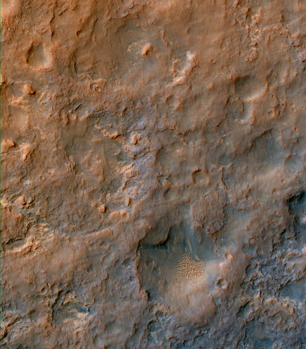
Tracking Curiosity’s progress towards “Mount Sharp” – the arrows point towards to tracks left by the rover as it heads southwest towards a gap in the dune field (seen lower right) sitting between it and the foothills of its primary destination. For scale, the wheel tracks are about 3 metres (10 feet) apart (click to enlarge)
The images show the rover’s tracks as it manoeuvred around obstacles on its route toward the lower slopes of “Mount Sharp”, and were captured in early December 2013 as the MRO, which acts the and primary communications relay between Earth and Curiosity, passed over the rover’s location at an altitude of some 250-316 kilometres (160-196 miles).
HiRISE first imaged the Mars Science Laboratory spacecraft while it was descending on a parachute to place Curiosity on Mars 17 months ago. Since then, it has provided updated views of the rover’s traverse, as seen from orbit.
A rover’s progress: a large image of Curiosity’s journey, as captured by the HiRISE camera aboard the Mars Reconnaissance Orbiter in December 11th, 2013. The rover itself is just out of frame to the lower left of the image. The orientation is so that north is to the top (click to enlarge)
At the time the images were captured, Curiosity had clocked-up some 4.61 kilometres (2.86 miles) since its arrival in Gale Crater in August 2012. The long trek in a generally southwest direction commenced in the latter half of 2013, after the rover had spent some six months within the “Glenelg” and “Yellowknife Bay” areas of the crater studying a range of rock and surface conditions which allowed Curiosity to meet criteria relevant to its primary mission objective – to determine whether Mars may have once harboured conditions in which life might have arisen.
NASA’s Curiosity Mars rover and tracks left by its driving appear in this portion of a Dec. 11, 2013, observation by the Mars Reconnaissance Orbiter. The rover is near the lower-left corner of this view. For scale, the two parallel lines of the wheel tracks are about 3 metres (10 feet) apart (click to enlarge)
On December 15th 2013, Kitely announced the first phase of a major overhaul of their pricing structures. That announcement covered the introduction of their new account types (Regular and Premium) and their Metered world options which have replaced their “time-based” system of payment options.
I covered that announcement in some depth at the time, noting that there would be further clarification to come from Kitely on elements of the new Regular account, as well as information on the new Fixed-price options. On January 1st 2014, Kitely followed-through on their promise of providing this additional information when they issued a further pricing update.
More on Account Types
As I reported in December alongside of Kitely’s initial blog post on this subject, the company has introduced two account types, Regular and Premium. The salient points to note on these are that:
The Regular account is free of charge and includes a single Metered region and a one-off 6-hour trial period which can be used in developing their Metered region(s)
The Premium account costs $19.95 a month, and includes up to five Metered regions with the ability to visit any metered region on Kitely (their own or anyone else’s) for free
Either type of account can be used when joining Kitely
Either type of account can be used when purchasing Fixed-price world options (of which more late in this article)
Either type of account can add further Metered regions at the rate of 10 KC per day per Metered region (+ access costs for Regular accounts, where applicable).
Metered Regions and Regular Account Visitors
The key point to grasp here is that the time anyone with a Regular account spends visiting any Metered region (including their own) must be paid for by the region holder. This means that someone with a Metered region will be charged at the rate of 1 Kitely Credit (KC) for each minute a Regular account holder spends visiting that region.
The only exception to this is the initial 6-hour trial period Regular account holders are given in order to start developing their own Metered region. Once this trial period has been used, a Regular account holder can either continue to pay for their time on their own region(s) at the rate of 1KC per minute, or opt to pay for one of the Fixed-price world options (there is no charge for anyone visiting Fixed-price regions) or opt to upgrade to Premium (both of these latter options are open to Regular account holders at any time).
Because there is a cost involved in having Regular account holders visit a Metered region, Kitely has included an option for region holders to block Regular accounts from accessing their Metered regions if they so wish, thus preventing the build-up of unwanted costs in respect of such visits. The Kitely blog post elaborates in detail on how this access restriction can be set.
Fixed-price World Options
As of January 1st, 2014, the company has discontinued its original $40.00, $60.00, $80.00 and $100.00 fixed-prix options – although users already paying for these options can continue to do so if they wish. Three new Fixed-price options have been introduced in their place, referred to as the Starter World, Standard World and Advanced World options, as defined below.
Kitely’s new fixed-price options, available to both Regular and Premium account holders (image via Kitely)
Both the Starter and the Standard World options come with slightly reduced resources, as indicated, while the Standard and Advanced World options include the ability to combine the regions included in those worlds into a single Advanced Megaregion. As with the old Fixed-price options, no-one is charged for the time anyone spends on a Fixed-price region.
Whether or not users on one of the discontinued Fixed-price options will want to change to one of the new options will depend upon on a number of things, such as the complexity of their build(s), and their typical numbers of daily users or their requirements for avatar-intensive events. However, the ability to swap is there for them to use, if they so wish.
General Feedback
It will be interesting to see broader reaction to the idea of Metered region holders having to pay for any visits made to their regions by Regular account holders – and how many Metered regions are closed to Regular account holders as a result (I have already closed my own Kitely region to Regular account access, for example). However, the initial reaction to these changes has been favourable, even allowing for the confusion which occurred when the initial part of the restructuring was announced in December 2013.
As it is, the new Metered and Fixed-price payment options continue Kitely’s tradition of offering competitive and flexible payment options, and may well serve to attract new users into giving the platform a try.
AvaCon, former organisers of the now defunct Second Life Community Convention, and co-organisers of the OpenSimulator Community Conference, have launched their completely revamped website ahead of what looks like being a very busy year for the team.
The new website is a crisp, clean, easy-to-navigate blog-style environment (the engine driving the site is WordPress.org with a professional theme courtesy of Kriesi Art). This is perhaps a long-overdue overhaul to AvaCon’s web presence, and it certainly gives a whole new look and feel – and vibrancy – to the site.
In 2013, AvaCon co-organised and hosted the first Annual OpenSimulator Community Conference, (OSCC) which I previewed in these pages (and was booked-in to attend before RL got in the way). The event itself was a great success for both AvaCon and the Overte Foundation, and they’re now planning the 2014 event.
Those wishing to help with the 2014 conference are invited to e-mail AvaCon to volunteer their services. In the meantime, videos from the 2013 conference are available on YouTube for those wishing to catch-up on events, and AvaCon have provided a link to a fascinating visualisation video by Nebadon25 showing the OpenSimulator code commits by core developers, charting the growth of the project.
Metaverse Cultural Series
In 2013, AvaCon also launched the Metaverse Cultural Series, a set of events which featured performances and lectures highlighting unique aspects of metaverse culture, and which took place in multiple virtual world spaces. The inaugural series showcased innovative artists, thinkers, performers, and academics whose work is on the forefront of exploring what it means to work, play, and live in the emerging metaverse.
In 2014, AvaCon plan to expand the series, and will be issuing a call-for-proposals in January, 2014. Successful presenters and venue hosts will receive a $50 USD honorarium for accepted presentations, and I’ll be endeavouring to bring news on things once the call goes out publicly.
All-in-all, 2014 looks to be an exciting year for AvaCon, and I’d like to extend my congratulations to the team on their successes in 2013 and my best wishes for 2014.
NASA’s Curiosity rover Has completed a significant software upgrade, marking the third time the rover’s flight software has been updated since arriving on Mars in August 2012. The update was originally scheduled to take place over the course of a week in early November. However, during the course of the software upload, Curiosity unexpectedly committed a (non-threatening) software reboot (technically referred to as a “warm reset”), which eventually saw the software reverted to its original state.
Analysis of data received as a result of the reset revealed a catalogue file for the existing onboard software was triggered as a result of the newly uploaded flight software. As a result of this analysis the rover team were able to determine the steps required to ensure the correct software execution took place before allowing the rover to resume normal operations using the existing flight software (version 10).
A second attempt was then made up upload and execute the new flight software (version 11) over the course of a week earlier in December, which saw the rover transition to the new software without incident.
The new software further expands the rover’s ability to deploy and use its robot arm and the turret-mounted science instruments and tools while the vehicle is operating on sloping surfaces – a vital requirement once Curiosity starts exploring the lower slopes of “Mount Sharp”. The software also further enhances the rover’s ability to safely store and retrieve navigational data, increasing its autonomous driving abilities even further.
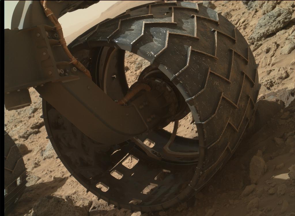
Over the last several weeks, Curiosity has been driving over exceptionally rugged terrain while en route to a point where it can traverse a series of sand dunes lying between it and “Mount Sharp” and start its explorations there. As a result of this, concerns have been raised that the rover’s six aluminium wheels are perhaps suffering an accelerated wear.
While the wheels can sustain a significant amount of damage without impairing the rover’s driving abilities, the mission team have decided to locate and drive the rover to a relative smooth area of Gale Crater where the robot are can be deployed to use the Mars Hand Lens Imager (MAHLI) to inspect each wheel for holes and other signs of damage.
“We want to take a full inventory of the condition of the wheels,” said Jim Erickson, project manager for the NASA Mars Science Laboratory Project. “Dents and holes were anticipated, but the amount of wear appears to have accelerated in the past month or so. We would like to understand the impact that this terrain type has on the wheels, to help with planning future drives.”
Depending upon the outcome of these checks, it may be that mission planners will opt to review the rover’s course to “Mount Sharp” and destinations along the way in order to try to reduce the amount of time spent traversing such rough terrain.
Curiosity’s left front wheel shows signs of accelerated wear as a result of travelling across terrain that is rough even by Martian standards. As a result of this, mission managers plan to have all six wheels checked-out for wear and tear in the near future. This image was taken by the Mars Hand Lens Imager (MAHLI) mounted on the rover’s robot arm turret on Sol 469 (November 30th, 2013). Note, also, the heavy coating of dust and dirt on the wheel’s drive arm. At the time this image was captured, Curiosity had driven 4.47 kilometres (2.78 miles).
Almost Four Miles
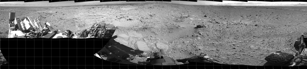
On December 8th, 2013 – Sol 477 of the mission, Curiosity clocked-up a distance of 4.61 kilometres (3.86 miles), and the rover paused to take a series of images of its location using the mast-mounted monochrome Navcams, which were then put together to form a cylindrical mosaic (below).
Click to enlarge
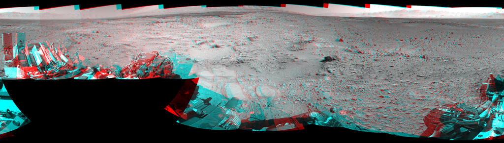
In the image, north is at either end of the mosaic, and south in the centre . The black squares are areas outside of the visual range of individual images used to create the mosaic. The images were individually captured by the left and right Navcam systems, and the two sets of images combined to offer a stereo view of Curiosity’s surroundings which can be seen using red-blue glasses with the red lens on the left (below).
Click to enlarge
In my last MSL report, I referenced the research into the age of the rocks in Gale Crater and the effects of weathering and erosion. Understanding of both helps scientists learn about the processes at work close to the surface of Mars, infer whether features were predominantly formed by action of wind or water (or a combination of both, and where one took over from the other), and understand relative levels (in ages) different rock has been exposed to cosmic radiation. Further images used in that research have since been released.
Click to enlarge
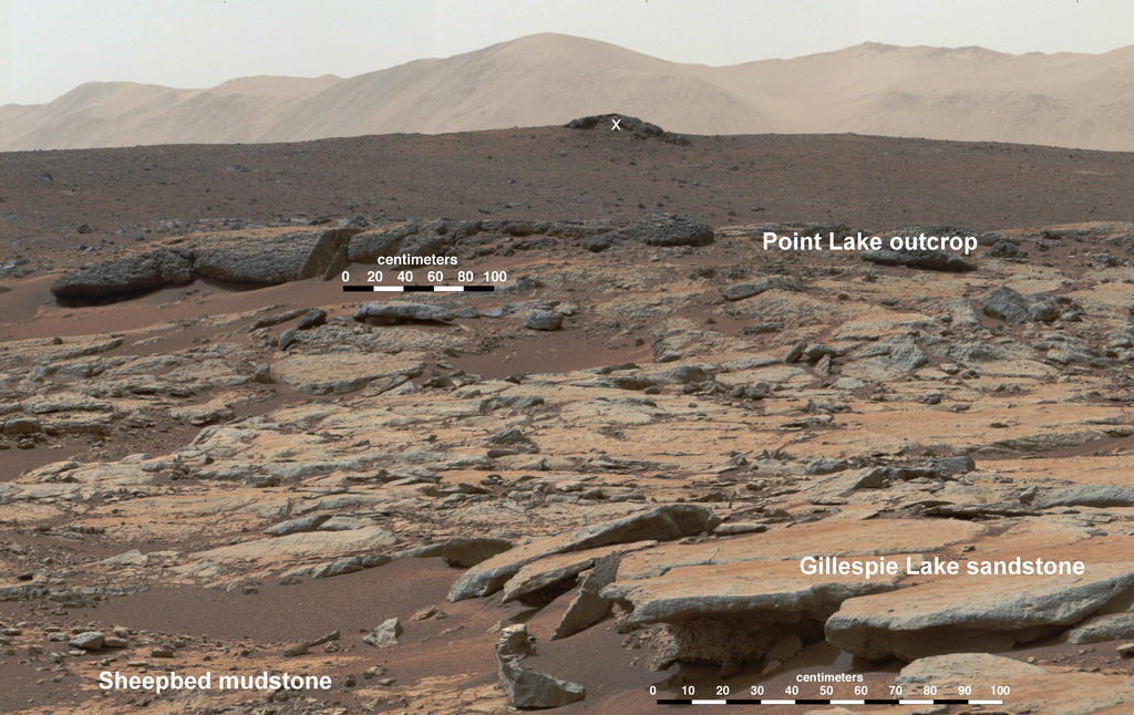
The image above show a mosaic put together using pictures captured by Curiosity’s Mastcam system on Sol 188 (February 14th, 2013), while the rover was operating in the “Yellowknife Bay” area. Looking west-northwest, the scene shows the various levels of rock which have been exposed in a process known as wind-driven scarp retreat, which can be described as the sideways erosion of a vertical face.
In the lower left corner is the “Sheepbed” mudstone deposit, which contains the “Cumberland” rock formation from which Curiosity gathered drilling samples. Gas analysis of the samples (some of which were saved by the rover and further analysed during the long road trip towards “Mount Sharp”) suggest the rock has only been exposed for about 80 million years – which is a lot more recent an exposure than previous estimates of the overall exposure of the Martian surface to the rigours of cosmic and solar radiation had suggested.
The evidence for wind erosion being the primary cause of exposure is strongly suggested to the right of the image, where erosion of the mudstone is clearly undercutting the “Gillespie Lake” sandstone layers. These layers were about 15.4 metres (50 feet) from the rover. The mid-image “Point Lake” layers are some 36 metres (118 feet) from the rover, while the rocky outcrop marked by the white “X” is around 240 metres (780 feet) away, and on an elevation about 13 metres (43 feet) higher than “Sheepbed” and “Gillespie”.
A key aspect of understanding how and when such exposure of previously hidden rock layers occurred is that it gives the rover team better insight for selecting future targets for drilling to investigate whether organic chemicals have been preserved in rocks.
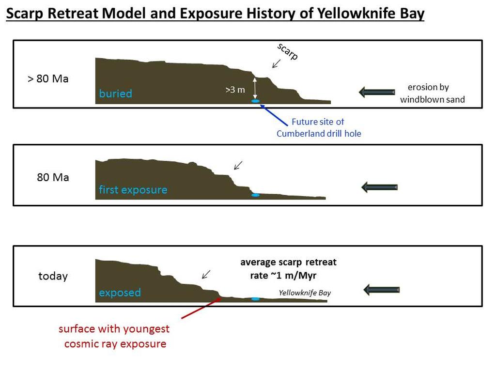
This set of drawings depicts cross sections of the “Yellowknife Bay” area of Mars’ Gale Crater at three points in time going back more than 80 million years (>80 Ma). Analysis of samples indicate the “Cumberland” rock target has been exposed at the surface for about 80 million years. Longer ago than that, the drill site was covered with about 10 feet (3 meters) of rock, as depicted in the top panel. At about 80 million years (middle panel), “Cumberland” was exposed as the scarp retreated due to abrasion by windblown sand. The sideways erosion, or retreat, occurred at an average rate of about one metre (3 feet) per million years (click to enlarge)
NASA’s Mars Science Laboratory (MSL) rover Curiosity chalked-up another milestone on October 30th, 2013, when the laser which comprises part of the Chemistry and Camera instrument (ChemCam) system mounted at the top of the rover’s mast, was fired for the 100,000 time.
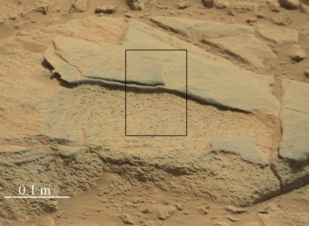
The shot was one of a series of 300 fired at a total of 10 locations on a rock called “Ithaca”, and was taken at a range of 4.04 metres (just over 13 feet) from the target. The laser is used to vaporise tiny amounts of an object (the target area being around the size of a pin head), producing a spark of plasma (ionised gas). This spark is observed via a telescope which also forms a part of the ChemCam system, and the spectrum of light from the spark is analysed to identify chemicaal and mineral elements within it.
The rock “Ithaca” shown here, with a rougher lower texture and smoother texture on top, appears to be a piece of the local sedimentary bedrock protruding from the surrounding soil in Gale Crater. This image, taken by Curiosity’s Mast Camera (Mastcam), was captured on Sol 439 (October 30th, 2013). The rectangle indicates the area where ChemCam used its laser and remote micro-imager to inspect “Ithaca”. That inspection included the 100,000th laser shot fired by ChemCam on Mars
Each pulse from the laser delivers more than a million watts of power for about five one-billionths of a second. The technique used by ChemCam, called laser-induced breakdown spectroscopy, has been used to assess composition of targets in other extreme environments, such as inside nuclear reactors and on the sea floor. Experimental applications have included also environmental monitoring and cancer detection. MSL is the first mission to use the technique on another planet.
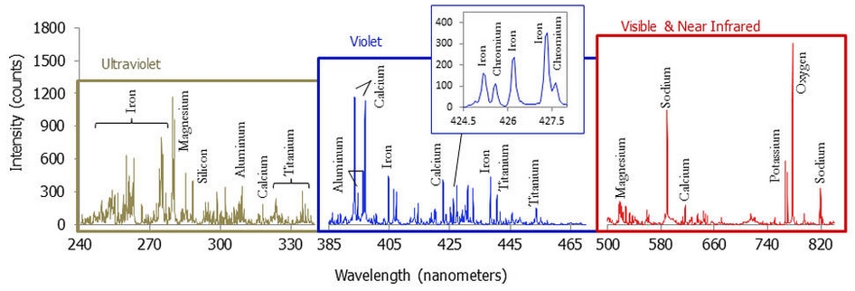
A graph showing a spectrum recorded by ChemCam which averages data from multiple laser firings at the same point on the rock “Ithaca” on Sol 439, and which included to 100,000th laser shot. The spectrum is typical of Martian volcanic (basalt) material. Although Ithaca is a sedimentary rock, the particles in the sediments that became the rock originated in igneous source rocks. The elements identified from the spectrum include a standard major-element suite of silicon, magnesium, aluminium, calcium, sodium, potassium, oxygen and titanium. Chromium and manganese, though not labelled, were also present (click to enlarge)
Virtually every shot taken by the laser yields a spectrum of data which is returned to Earth. Most targets get zapped at several points with 30 laser pulses at each point. An international team of scientists and students is mining information from ChemCam to document the diversity of materials on the surface of Gale Crater and the geological processes that formed them. The range of materials recorded so far includes dust, wind-blown soil, water-lain sediments derived from the crater rim, veins of sulphates and igneous rocks that may be ejecta from other parts of Mars.
Since reaching the 100,000 total in late October, the laser has been fired a further 2,000 times. ChemCam also includes a micro-imager camera, which has taken over 1600 images during the time the rover has been operating on Mars.
The ChemCam mast element on Curiosity
Four Billion Years
In a little more than a year on the Red Planet, Curiosity has determined the age of a Martian rock, found evidence the planet could have sustained microbial life, taken the first readings of radiation on the surface, and shown how natural erosion could reveal the building blocks of life. MSL team members presented these results and more from Curiosity in six papers published on December 9th, 2013 by Science Express and presented them in press briefings and talks at the Fall Meeting of the American Geophysical Union in San Francisco.
As a part of its operations, Curiosity has carried out a number of sample drillings into rocks on Mars. The second rock, dubbed “Cumberland” from which the rover obtained cuttings for analysis is now the first rock ever to be dated while sitting on another planet. Analysis of the mineral ingredients in the cuttings obtained from “Cumberland” estimates the age of the rock to be about 3.86 to 4.56 billion years; this matches estimates as to the overall age of Gale Crater itself, obtained through other means, which suggests that the techniques being used to analyse the samples gathered by the rover are reliable.
“The age is not surprising, but what is surprising is that this method worked using measurements performed on Mars,” Kenneth Farley, from the California Institute of Technology and a co-author of one of the new papers, said. “When you’re confirming a new methodology, you don’t want the first result to be something unexpected. Our understanding of the antiquity of the Martian surface seems to be right.”
Before they could measure rocks directly on Mars, scientists estimated their ages by counting and comparing the numbers of impact craters on various areas of the planet. The crater densities are correlated with ages based on comparisons with crater densities on the moon, which were tied to absolute dates after the Apollo lunar missions returned rocks to Earth.
The Cumberland sample analysis was a fundamental and unprecedented measurement which had been considered unlikely even as recently as the rover’s arrival on Mars in August 2012. To obtain it, Farley and his colleagues adapted a 60-year-old radiometric method for dating Earth rocks that measures the decay of an isotope of potassium as it slowly changes into argon, an inert gas. Argon escapes when a rock is melted. This dating method measures the amount of argon that accumulates when the rock hardens again.
The researchers also assessed how long Cumberland has been within about an arm’s reach of the Martian surface, where cosmic rays striking the atoms of the rock produce build-ups of gasses Curiosity can measure. The analysis of different gases present in the rock yielded exposure ages in the range of 60 million to 100 million years. This suggests shielding layers above the rock were stripped away relatively recently. Combined with clues of wind erosion Curiosity has observed, the exposure-age discovery points to a pattern of windblown sand eroding relatively thick layers of rock, which form a retreating vertical face, or scarp.
“The exposure rate is surprisingly fast,” Farley said. “The place where you’ll find the rocks with the youngest exposure age will be right next to the downwind scarps.”
Kitely, the on-demand virtual world platform, is revising its pricing structure.
The changes, which come into effect from January 1st, will see both the Metered (also referred to as “Time-based”) payment options and the Fixed-price payment options revised with the aim of presenting a more streamlined set of options which more closely suit the needs of Kitely users.
Changes to Metered (time-based) Payment Options
The first part of these changes, as announced in a blog post and an e-mail sent to users, will see the Metered payment options substantially revised. Currently, these payment options comprise four plans:
Free: 1 full Metered Region plus 2 hours in-world time a month
Bronze plan: $5.00 a month, 2 full Metered Regions and 30 hours in-world time a month
Silver plan: $20.00 a month, 10 full Metered Regions and 120 hours in-world a month
Gold plan: $35.00 a month, 20 full Metered Regions and unlimited time in-world.
The monthly in-world time offered under the Free, Bronze and Silver plans can be used as time spent by the user on their own Metered Region(s), and/or as time they spend visiting other Metered Regions. Additional time for these plans, if needed during a month, can be paid for at the rate of 1 Kitely Credit (KC) per minute. Under all of the plans, additional Metered Regions in excess of the stated allowance can be obtained at a rate of 10 KCs per day per Metered Region.
As of January 1st, 2014, these plans will be replaced by two new account types:
A Regular account, which will include 1 free Metered Region, with additional options still to be announced by Kitely
A Premium account, which will cost $19.95 a month, include up to 5 free Metered Regions and the ability to visit any Metered Regions (your own or anyone else’s) for free (neither you nor the region’s manager pay for your visit).
For anyone who is either on, or who signs-up to, the Silver or Gold time-based plans before the end of the year (whether they are an existing user or new to Kitely), there is good news: their plan will be grandfathered-in under the Premium account, with additional benefits. This means that:
Those with the Silver plan will continue to pay $20.00 a month and will gain unlimited access to any Metered Regions as well as retaining their allowance of up to 10 Metered Regions (so they will pay $0.05 more a month than those signing-up for Premium accounts after January 1st, 2014, but have up to twice the number of Metered Regions)
Those with the Gold plan will continue to pay $35 a month and will retain their unlimited access to any Metered Regions, and the total number of Metered Regions they can have at no additional charge will be increased from 20 to 30.
This incentive is being provided to encourage people who are considering Kitely as a future option to make the move now and take advantage of this limited-time offer before it expires.
Those on the Bronze plan (which has been discontinued as an option with immediate effect) who do not upgrade to either a Silver or Gold plan before January 1st 2014, will be automatically downgraded to the new Regular account. Any second Metered Region they have developed under their Bronze plan will then be charged for at the standard rate of 10 KCs a day (the equivalent to paying as little as $1.00 a month for it, if buying KCs in bulk).
Those opting to stay with the Regular account after January 1st 2014 (whether they were on the Free or Bronze plan) will still be able to purchase additional Metered Regions at the rate of 10 KCs a day. They will also be able to upgrade to a Premium account if they wish, but they will not enjoy any of the grandfathered benefits on offer until the end of December 2013.
There is one other change with the new Metered payment options, and that is in relation to OAR (OpenSim Archive) file operations. OAR allows users to back-up their regions to their hard drive for use elsewhere, while fully respecting the permissions system (thus preventing users from exporting objects when they don’t have the required permissions as set by the objects’ creators). Currently, each OAR operation cost 10 KCs for Metered Regions. From January 1st 2014, this will be increasing to 150 KCs per operation for Metered Regions.
Kitely CEO Ilan Tochner (via Google+)
Even without the grandfathering of existing Silver and Gold account plan holders, the new Premium account still offers significant value for money, as Ilan Tochner, Kitely’s CEO and co-founder, pointed-out as we discussed the changes.
“This means that a group of builders, each on a Premium account, can get a LOT of land in Metered Regions and not have to think about time while visiting those regions,” he said, “and they can have all their Premium account friends with them in-world for as long as they want without thinking about time even though they are using Metered Regions.”
 Curiosity, the NASA rover carrying the Mars Science Laboratory is continuing towards its rendezvous with the foothills of “Mount Sharp” (Aeolis Mons) in Gale Crater, Mars. As such, there is little coming out of NASA in terms of updates on progress (which would likely sound the robotic equivalent of “Are we there yet?” “No!” cycles).