Of Martian walkabouts, pictures from a comet, and getting ready to fly

CuriosityIn my last report on the Mars Science Laboratory, I mentioned that Curiosity has been on a geology “walkabout” up the slopes of the “Pahrump Hills” at the base of “Mount Sharp” (more correctly, Aeolis Mons). The zigzagging route up through the area took the rover from “Confidence Hills” and the location of the last drilling operation up to a point dubbed “Whale Rock”, the drive being used to gather information on potential points of interest for further detailed examination.

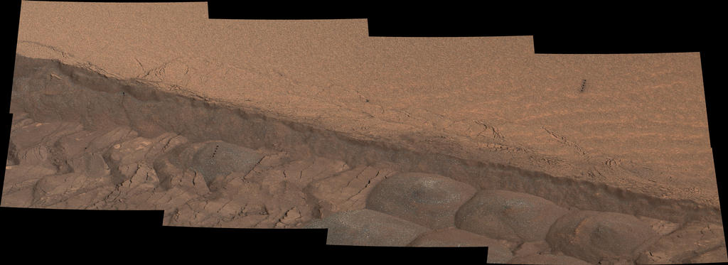
The exposed rocks in this transitional layering between the floor of Gale Crater, in which Curiosity arrived back in August 2012, and the higher slopes of “Mount Sharp” is expected to hold evidence about dramatic changes in the environmental evolution of Mars. Thus, the “walkabout”  – a common practice in field geology on Earth – was seen as the best means of carrying out a reasonable analysis of the area in order for the rover to be most efficiently targeted at specific locations of interest.

Curiosity’s walkabout, from “Confidence Hills” to “Whale Rock” in October, the rover is now working its way back to various points of interest for further studies

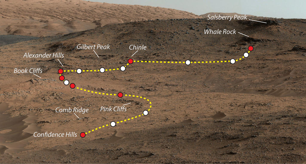
“We’ve seen a diversity of textures in this outcrop,” Curiosity’s deputy scientist Ashwin Vasavada (JPL) said of the drive. “Some parts finely layered and fine-grained, others more blocky with erosion-resistant ledges. Overlaid on that structure are compositional variations. Some of those variations were detected with our spectrometer. Others show themselves as apparent differences in cementation or as mineral veins. There’s a lot to study here.”

During the drive, Curiosity travelled some 110 metres, with an elevation of about 9 metres, using the Mastcam and the ChemCam (Chemistry and Camera) laser spectrometer system to inspect and test potential points of interest for more detailed examination at a later date. Since completing that drive, the rover has been working its way back through Pahrump Hills, this time examining specific targets using the robot-arm mounted Mars Hand Lens Imager (MAHLI) camera and spectrometer. Once this work has been completed, specific targets for in-depth analysis, including drilling for samples will for the core activity of a third pass through the area.

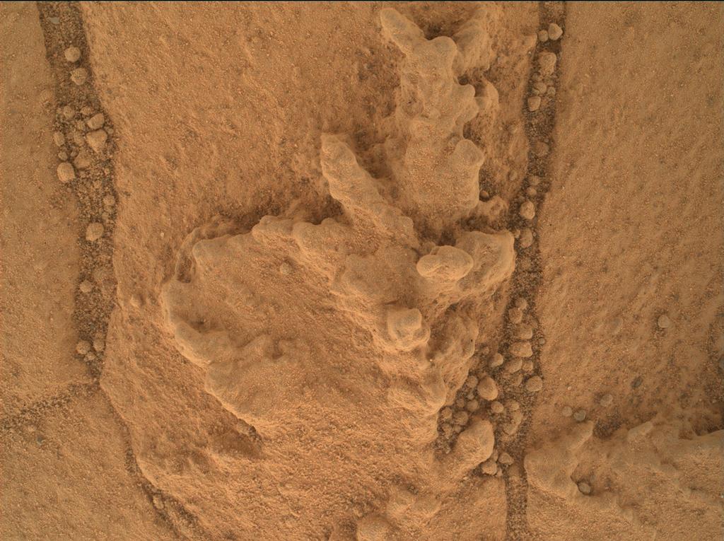
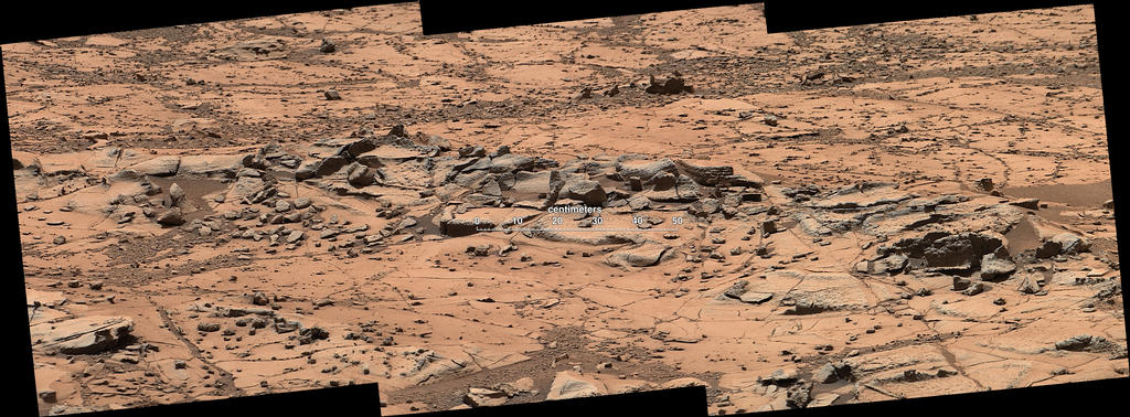
So far, two specific areas have been identified for detailed examination. The first, dubbed “Pelona” is a  fine-grained, finely layered rock close to the “Confidence Hills” drilling location. The second is a small erosion-resistant ridge dubbed “Pink Cliffs” the rover drove around on its way up the incline.

“Pink Cliffs” is roughly a metre (3ft) in length and appears to resist wind erosion more than the flatter plates around it.As such, it offers precisely the kind of mixed rock characteristics mission scientists want to investigate in order to better understand “Mount Sharp’s” composition. This image is a mosaic of 3 pictures captured on October 7th PDT, 2014 (Sol 771 for the rover) by Curiosity’s Mastcam. It has been white balanced to show the scene under normal Earth daylight lighting – click for full size.

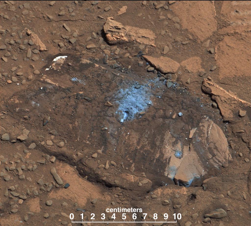
Another target of investigation has been the edge of a series of sand and dust dunes right on the edge of “Pahrump Hills”.  In August 2014, Curiosity attempted to use these dunes as a means to more quickly access the “Pahrump Hills” area, but the effort had to be abandoned when it proved far harder for the rover to maintain traction than had been anticipated, particularly given the rover has successfully negotiated sandy dunes and ridges earlier in the mission. As a result, scientists are keep to understand more about the composition of the dunes.

On November 7th, Curiosity was ordered to venture onto the dunes very briefly in order to break the surface of one of the rippled dunes and expose the underlying layers of sand in an effort to better understand why the rover found the sand such hard going the first time around, and what might be within these wind-formed dunes that would prove to be so bothersome to driving over them. Data gathered from the drive is still being analysed.

Spanning roughly 1.2 metres from left to right, a wheel track breaks the surface of a dust sand dune ripple on the edge of “Pahrump Hiils”. The MSL science team hope the exposed material within the ripple will help them understand why Curiosity found these dunes hard-going when trying to cross them in August 2014.

The work in the “Pahrump Hills” area has given rise to concerns over one of the two lasers in the ChemCam instrument. As well as the main laser, known for “zapping” targets on the surface of Mars in order to reveal their chemical and mineral composition, the system uses a second laser, a continuous wave laser, used for focusing the ChemCam’s telescope to ensure the plasma flash of vaporised rock is properly imaged when the main laser fires. Data received on Earth when using the ChemCam to examine rocks on the first pass through “Pahrump Hills” suggests this smaller laser is weakening and may no longer be able to perform adequately.

If this is the case, the laser team plan to switch to using an auto-focus capability with the telescope so it will automatically focus itself on a few “targeting” shots from the main laser ahead of any data-gathering burst of fire, allowing for proper telescope calibration.

Continue reading “Of Martian walkabouts, pictures from a comet, and getting ready to fly”

Of triumph and tragedy

The last week has seen some momentous and tragic events occur in the annals of space flight and space exploration, with tragedy leading the way following the break-up of Virgin Galactic’s SpaceShipTwo vehicle on Friday, October 31st, resulting in the death of co-pilot Michael Alsbury and the serious injury of pilot Peter Siebold.

The loss of SpaceShipTwo came just a few days after an Antares booster, operated by Orbital Sciences and which should have been launching an unmanned Cygnus resupply vehicle to the International Space Station (ISS), was ordered to self-destruct seconds after lifting off of the pad.

Understandably overshadowed by the loss of SpaceShipTwo was the news that China has enjoyed a further success as a part of its ambitious lunar mission plans, and NASA has achieved a further “first” on Mars with Curiosity.

The news from Curiosity came after what has been another period of relative quiet from the MSL team following the successful gathering of a rock sample from a drilling operation into a target rock outcrop dubbed “Confidence Hills” within the “Pahrump Hills” region at the base of “Mount Sharp”.

Since that time, Curiosity has been on something of a “walkabout”, as NASA JPL is calling it (“roll around” probably doesn’t give the right impression…) within the “Pahrump Hills” area whilst simultaneously analysing the samples gathered from “Confidence Hills” at the end of September, and also keeping an eye out for passing comets.

Curiosity’s “walkabout” in the “Pahrump Hills” at the base of “Mount Sharp” in October 2014. The route starts at “Confidence Hills”, the site of a successful drilling operation, and winds up to “Whale Rock”. Red dots indicate points at which the rover paused overnight, white dots denote points at which it stopped to gather images and data, perhaps over several days

As well as the familiar aboriginal reference, “walkabout” is also a term used by field geologists to describe walking across a rocky outcrop in order to determine the best places from which to examine it – which is precisely what Curiosity was ordered to do through October.

During the walkabout, Curiosity made a number of stops for data and image gathering, before arriving at a point dubbed “Whale Rock”, just below another high point which appears to mark the point at which “Pahrump Hills” join the “Murray formation”, the next destination for the rover once studies of “Pahrump Hills” has been completed. The rover will remain parked at “Whale Rock” as the science team analyses the images and data gathered in order to determine where the rover should return to carry out more detailed investigations.

The material obtained from the “Confidence Hills” drilling operation contained in the rover’s sample scoop after being sifted and graduated by the CHIMRA device in the rover’s robot arm turret, and about to be delivered to the input ports ready for analysis by the instruments in the rover’s body. This image was taken by Curiosity’s Mastcam, and has been white-balanced so that lighting conditions match daytime light on Earth

In the meantime, and in the “first” mentioned above, Curiosity has confirmed that the samples gathered from “Confidence Hills” contain mineral deposits what had been mapped from orbit. The mineral in question in Hematite – which has been found elsewhere on Mars by both of the MER rovers, Opportunity, and the now defunct Spirit.

However, the significance of the “Confidence Hills” analysis, carried out by the rover’s on-board Chemistry and Mineralogy (ChemMin) instrument, confirms predictions made from the analysis of data returned by the Compact Reconnaissance Imaging Spectrometer for Mars (CRISM) aboard the Mars Reconnaissance Orbiter that Hematite deposits would exist within the rocks of the mountain’s lower slopes. This confirmation gives the science team greater confidence that the analysis of orbital data can help them make even better choices of while the rover should carry out drilling operations etc. It also means that the rover’s on-the-spot analysis and observations can be set directly into the broader geologic history of “Mount Sharp” as obtained by orbital data.

Curiosity may spend weeks or months at Pahrump Hills before proceeding farther up into the “Murray formation” and on to “Hematite Ridge”, a further location of interest to scientists. The mineral is of particular interest to scientists not so much because it might be indicative of a water-rich history in the region (as was the case with the discoveries made by Opportunity and Spirit) – Gale Crater has already more than yielded enough evidence of wet conditions being prevalent in its past history. Rather, the hematite on and in “Mount Sharp” helps scientists further understand oxidation conditions within the region. Continue reading “Of triumph and tragedy”

Duck and Cover

Sunday October 19th marked the culmination of what is regarded as one of the most unique astronomical events to take place in human history – so unique, some commentators believe it may only happen once every million years or so: the opportunity to study something which may have existed before the Earth was created.

For the last several months, comet Siding Spring has been under observation as it hurtles through the solar system at an acute angle relative to the plane of the ecliptic – the imaginary line along which the planets orbit, and on Sunday October 19th, it made its closest approach to Mars, passing just in front of the planet relative to the Sun.

Siding Spring was first identified by Australian astronomer Rob McNaught, and bears the name of his observatory as a result, although officially it is catalogued as C/2013 A1. Since then, it has been under observation from a veritable armada of international space craft, and its passage past Mars presents further unique opportunities for observation and data-gathering.

Siding spring is a comet originating in the Oort cloud, and beleived to be making perhaps its first foray into the inner solar system, passing inside the orbit of Jupiter
Siding spring is a comet originating in the Oort cloud, and believed to be making perhaps its first foray into the inner solar system, passing inside the orbit of Jupiter

The comet has been identified as coming from the Oort cloud (or the Öpik–Oort cloud, to give proper recognition both astronomers who initially and independently postulated its existence). This is a spherical cloud of debris left-over from the creation of the solar system, occupying a huge area starting some 2,000-5,000 AU (2,000 to 5,000 times the distance from the Earth to the Sun) and extending out to around 50-100,000 AU – or about one light year away. Thus, Siding Spring represents some of the material “left-over” from the formation of the solar system 4.6 billion years ago – older than the Earth itself. In fact, such is the distance of the Oort cloud from the Sun, that some postulate the much of the material within it may actually come from stars which shared the same “stellar nursery” as the Sun.

There is nothing unique per se about comets coming from the Oort cloud – it is one of two places from which all comets originate, the other being the Kuiper belt (or Edgeworth–Kuiper belt, as it is also known in recognition of the two astronomers to postulate its existence in the form we now know it has). A disk of material also from the early history of the solar system, the Kuiper belt orbits the Sun at a distance of around 30-50 AU, and gives rise to “periodic” comets. These are comets which circle the Sun in periods of up to 200 years. Two of the most famous Kuiper belt comets are comet Halley, with it 76-year orbit, and comet Shoemaker-Levy 9, which broke-up during a close approach to Jupiter in 1992 prior to colliding with the gas giant in 1994.

Siding Springs passage through the solar system

What makes Siding Spring of interest to astronomers is that this is probably the first time in its long, cold history it has ever come inside the orbit of Jupiter since it was first nudged out of the Oort cloud. This led Dr Michael Brown, an astronomer at Monash University, to describe the comet as “essentially a refrigerator of pristine parts of the creation of the solar system. The particles it gives off are effectively opening up the door of the fridge so we can see what the solar system was like 4.6 billion years ago.”

John Grunsfeld, former astronaut and associate administrator for NASA’s Science Mission Directorate in Washington was equally enthused by the comet’s passage, referring to it as “a cosmic science gift that could potentially keep on giving.” Speaking at a press conference held earlier in the year to discuss NASA’s plans to observe Siding Spring, he continued, “The agency’s diverse science missions will be in full receive mode.” He went on, “This particular comet has never before entered the inner solar system, so it will provide a fresh source of clues to our solar system’s earliest days.”

The chance for scientific discovery notwithstanding, the comet’s path was initially a cause for concern, at least in terms of Mars’ future. Early attempts to track the comet’s likely route  “up” through the solar system suggested that rather than passing the Red Planet, Siding Spring would in fact smash into it.

Had the comet struck, estimates suggest it would have created a crater between 10 and 15km in diameter, depending on the actual size of the comet’s nucleus, thought to be between 700m and 1km across.  While that is certainly enough to result in quite an extraordinary bang and some severe changes in the Martian atmosphere (not to mention the sizable dent it would make in the planet’s surface), Mars has actually withstood much larger impacts in its time.

Take Hellas Basin, for example. It is the largest visible crater in the solar system, some 2,300km (1,440 miles) across, and with an ejecta ring some 7,000km (4,375 miles) across. It is believed to have been created by the impact of an asteroid some 400km (250 miles) in diameter.

The Hellas Basin, shown in purple in the image of the right, above. Deeper than Mount Everest is tall, the depression was likely caused by the impact of an asteroid some 400km across. The impact also resulted in the Tharsis Bulge on the opposite side of the planet, and shown in red in the image on the left, topped by the three massive Tharsis volcanoes, and split by the 5,000km length of the Vallis Marineris

As Grunsfeld noted, such is the scientific opportunity presented by the comet, that NASA has put a significant number of assets in the front line of tracking and observing Siding Spring. These include the Hubble Space Telescope, the Spitzer infra-red space telescope, the WISE infra-red space telescope, the Chandra X-ray observatory, the Kepler orbital observatory (used in the search for Earth-sized extra-solar planets) and more, as well a host of ground-based observatories.

Foremost in the front line, by dint of the comet’s close passage past Mars, are NASA’s orbital and surface vehicles there. Curiosity, Opportunity, the Mars Reconnaissance Orbiter (MRO), Mars Odyssey and MAVEN, together with Europe’s Mars Express and India’s MOM, are all watching the comet, although for the orbiting spacecraft, this comes with a degree of risk.

Siding Spring has been, and is, under observation by an armada of science probes and also from observatories on Earth
Siding Spring has been, and is, under observation by an armada of science probes and also from observatories on Earth – including these from NASA

Continue reading “Duck and Cover”

Martian technology comes down to Earth; NASA asks students to help

CuriosityThere’s some interesting news coming from the Mars Science Laboratory, with NASA revealing that Curiosity is contributing to matters of safety here on Earth.

Over the decades, NASA has established a strong track record for space-focused technologies having spin-off applications here on Earth. The Apollo programme, for example, lead to some 1,400 patents and technical developments which impacted all of our lives. These have included:

  • Physical therapy and athletic development machine used by football teams, sports clinics, and medical rehabilitation centres
  • Water purification systems used in community water supply systems and cooling towers to kill bacteria, viruses and algae
  • Freeze-drying technology to preserve nutritional value and taste in foods; improvements in kidney dialysis arising from the need to recycle fluids in space
  • The widespread use of flame-resistant textiles used by fire fighters, service personnel, etc.
  • Sensor system to detect the presence of hazardous gases in oil fields, refineries, offshore platforms, chemical plants, waste storage sites, and other locations where gases could be released into the environment.
aaa
Lance Christensen of NASA’s Jet Propulsion Laboratory, demonstrates the gas leak detection device developed using his tunable laser spectrometer develop for the Mars Science Laboratory

It is in reference to this last aspect of spin-off technologies that Curiosity is contributing to safety on Earth.

On Wednesday October 2nd, NASA’s JPL announced that technology developed for the Curiosity rover is now being tested by the Pacific Gas and Electric Company (PG&E) which should enable their personnel to identify possible leak locations, fast-tracking their ability to repair gas leaks.

The new system utilises laser-based technology developed for MSL to aid detection of Methane on Mars. It is a spin-off of the tunable laser spectrometer, developed by JPL science engineer Lance Christensen, and one of the principal science instruments carried within the body of the Mars rover. The PG&E application utilities elements of the laser system together with a tablet computer in a hand-held device. This allows field engineers to detect trace elements of gas coming from a leak by passing the detector over the ground above the line of the pipe. Testing is currently underway, and it is hoped that if successful, it will see the system introduced for general use in the US utility industry in 2015. It is particularly relevant to PG&E, after one of their gas pipes ruptured in 2010 and the resultant explosion killed eight people.

Curiosity’s compact spectrometer systems have already given rise to the testing of a new generation of compact, portable, multi-purpose spectrometers for use by geologists and researchers working in the field, and the development of this system with PG&E marks another significant step in NASA’s tradition of contributing back to technology, engineering, safety, etc., here on Earth.

NASA 3D Printing Contest for Students

3D printing has the potential to revolutionise many areas of life and business – both on Earth and in space. Earlier in 2014, for example, British Aerospace has received European Aviation Safety Agency (EASA) Form 1 certification approval to use a 3D printed part in one of their aeroplanes, and the European Space Agency (ESA) is investigating the use of 3D printing methods for space applications.

NASA, in partnership with the American Society of Mechanical Engineers Foundation has now opted to launch a competition for US school and college students, to design and submit a digital 3-D model of a tool that they think astronauts will need in space.

Introducing the competition in a video (below), NASA astronaut Doug Wheelock says, “As you know, we don’t have overnight shipping up in space, so when we really need something, we have to wait. To be able to make parts on demand will forever change that for us.”

The competition, launched in late September, has a closing date of December 15th, 2014. Two grand prizes are on offer: the winner of the 5-12 year age group will get a 3-D printer for his or her school, while the winner in the 13-19 age range will receive a trip to NASA’s Payload Operations in Huntsville, Alabama, where the student will watch his or her object manufactured on the International Space Station.The winners will be announced in January 2015, and full details for entry can be found on the Future Engineers website.

Continue reading “Martian technology comes down to Earth; NASA asks students to help”

A Mars Namaste and taxis to the space station

CuriosityIt’s been a busy couple of weeks on and around Mars and with space exploration in general. This being the case, I’m going to be tagging some of the other items of potential interest to the end of this Curiosity update.

On September 24th, Curiosity obtained its first sample of rock gathered from the foothills of “Mount Sharp”, or Aeolis Mons as it is more correctly named. The sample was taken from a rock in the area dubbed “Pahrump Hills”, an uprising within the initial transitional zone between what is regarded as the floor of Gale Crater and the material making up the huge mound of “Mount Sharp” located at the centre of the crater.

The rover officially arrived within the area of interest on September 19th, and conducted surveys of its surroundings and a potential candidate area was selected for sample gathering. On September 22nd, an initial “mini drill” test operation was carried out on a rock surface in the target area, dubbed “Confidence Hills”, to assess its suitability for sample gathering.

A mosaic of images captured by Curiosity's Mastcam showing the Pahrump Hills area the rover is currently investigating (foreground) and the Murrary formation, a near-term destination, beyond
A mosaic of images captured by Curiosity’s Mastcam showing the Pahrump Hills area the rover is currently investigating (foreground) and the Murray formation, a near-term destination, beyond – click any image for full size

As noted in a previous update, “mini drilling” operations are used to test a potential target for a range of factors prior to actually committing the rover’s drill to a sample-gathering exercise, the intention being to ensure as far as possible that nothing untoward may happen which may damage the drill mechanism or adversely impact future sample gathering work.

The September 22nd mini drilling was important for two reasons; not only was it intended to assess the suitability of the target rock for sample gathering, it also marked the first time the drill cut into what is essentially “new” and “softer” material compared to previous drilling activities, and it was doubly unclear as to how the drill or the rock might react.

The bore hole image from the September 24th sample-gathering at “Parump Hills”. A “merged-focused product” combining a set of images captured by the Mars Hand Lens Imager (MAHLI) from just 2 centimetres above the hole, it show the bore cut by the rover’s drill and surrounding tailings which, interestingly, don’t share the same distinctive light gray colouring seen with samples gathered on the crater floor. The hole is 1.6cm across and about 6 cm deep. The images were taken on September 24th, 2014, during the 759th Sol, of Curiosity’s work on Mars

The sample-gathering drilling took place on September 24th, PDT (Sol 759 for Curiosity on Mars) and resulted in cutting a hole some 6 centimetres (2.6 inches) deep into the target rock and the successful gathering of tailings. “This drilling target is at the lowest part of the base layer of the mountain, and from here we plan to examine the higher, younger layers exposed in the nearby hills,” said Curiosity Deputy Project Scientist Ashwin Vasavada following the operation. “This first look at rocks we believe to underlie Mount Sharp is exciting because it will begin to form a picture of the environment at the time the mountain formed, and what led to its growth.”

Curiosity is liable to stay within the “Pahrump Hills” area for a while prior to moving up onto the Murray Formation above it, which is regarded as the formal boundary area between “Mount Sharp” and the crater floor, and as such is designated a target of particular interest. As a part of its studies of “Pahrump Hills”, and as well as gathering an initial rock sample, the rover has been surveying the rocks in its immediate surroundings with other instruments including the ChemCam laser system and the high-magnification Mars Hand Lens Imager camera, also mounted on the robot arm.

Of particular interest to the science team have been a series geometrically distinctive features on the rock surface. These are thought to be common to the Murray formation mudstones, and are believed to be the accumulations of erosion-resistant materials. They occur both as discrete clusters and as dendrites with formations arranged in tree-like branching. By investigating the shapes and chemical ingredients in these features, the team hopes to gain information about the possible composition of fluids at this Martian location long ago.

Another merged-focused image from MAHLI, showing accumulations of erosion-resistant materials in the “Pahrump Hills” area on the slopes of “Mount Sharp”. Similar features on Earth form when shallow bodies of water begin to evaporate and minerals precipitate from the concentrated brines. The width of the image covers about 2.2 centimetres, and it combines a series of images captured on September 23rd, 2014, during Curiosity’s 758th Sol

Currently, the sample gathered from the “Confidence Hills” are held within CHIMRA, the Collection and Handling for In-Situ Martian Rock Analysis system, in the rover’s robot arm. This is a mechanism that allows sample material to be graded by the size of the tailings by passing them through a series of sieves as the robot arm is vibrated at high rates, producing multiple samples which can then be delivered in turn to the rover’s onboard science instruments for detailed analysis.

Continue reading “A Mars Namaste and taxis to the space station”

J’arrive: a new chapter begins

CuriosityOn Thursday September 11th, a special teleconference was held by the NASA Jet Propulsion  Laboratory to discuss the status of the Mars Science Laboratory and the Curiosity rover.

The conference featured Jim Green, director, Planetary Science Division, NASA Headquarters, Washington, John Grotzinger, Curiosity project scientist, California Institute of Technology, Pasadena and Kathryn Stack, Curiosity Rover mission scientist, NASA’s Jet Propulsion Laboratory, Pasadena. California, and marked the first direct conference on the mission hosted by JPL since the start of the year.

The focal point for the briefing was to announce that just over two years since its arrival on Mars, having covered a distance of some 6 kilometres and having already fulfilled its primary mission objective – to locate a region on Mars which shows both chemical and geological indications that it may once have been amenable to development and support of microbial life – the rover had, again in geological terms, arrived at its primary exploratory target: Aeolis Mons, which NASA refers to as “Mount Sharp”.

Curiosity still has around two kilometres left to drive before it can be said to be actually “on” or climbing Mount Sharp, but the changes in geology and terrain which it is now encountering are sufficiently clear for the science team to state the rover is effectively traversing the “boundary” between the floor of Gale Crater and the slopes of Aeolis Mons itself.

Originally, it had been intended to drive the rover further south from its current location near an uprising dubbed the “Pahrump Hills” – originally seen as a potential target site for further sample drilling – to a series of low buttes named after the late co-founder of The Planetary Society, Bruce Murray. From orbit, this had been seen as the best route by which the rover could skirt an extended line of sand dunes lying between it and “Mount Sharp” and commence a climb up onto the lower slopes.

However, further examination of the terrain adjacent to the Pahrump Hills / Zabriskie Plateau has revealed it to be softer than the terrain than the rover has been crossing, and potentially more suited to driving onto the slopes of the mound. Dubbed the “Murray Formation”, this terrain also forms a visible boundary between the Mount Rainer-sized mound of “Mount Sharp” and the crater floor sediments, and so offers the potential for further science discoveries. Thus, from a driving characteristics point of view and a science perspective, it offers a shorter, more interesting route onto the mountain proper.

The view from “Amargosa Valley”: a mosaic of images capture by Curiosity’s Mastcam showing the “Pahrump Hills” (centre of the image, just above the scale bar), above which sits the Murray Formation and the revised route up onto the lower slopes of Mount Sharp (click any image for full size)

As well as being geologically different to the sediments of the crater floor, the Murray Formation is topographically different as well, which is driving a lot of interest in the science team in terms of what it might indicate about the way in which “Mount Sharp” was formed. The floor of Gale Crater – more correctly known as Aeolis Palus – bear the marks of considerable cratering which can be seen from orbit. However, the layers of the Murray Formation – essentially a scarp between the crater floor and Aeolis Mons – have almost no visible cratering at all.

The topological differences between the plains of Gale Crater and the slopes of Mount Sharp can be seen in this false colour image. Note the rich cratering evident across the sedimentary basin of Gale Crater and the almost complete absence of cratering along the Murray Formation.

During the course of the next few weeks, the rover will pass over / around Pahrump Hills, hopefully gathering a suitable rock sample using the “compressed drilling” routine,. Then it will turn more sharply southwards than originally planned, travelling directly onto the Murray Formation, rather than continuing in a more south-westerly direction to Murray Buttes before turning onto the slopes of the formation. The rover will still study the area of the Murray Buttes, but will now do so at their eastern extremes, allowing the science team to also investigate some nearby sand dunes.

While “Bonanza King” proved to be unsuitable for drilling for an actual sample for analysis, it did provide sufficient data to help the team in determining a revised science programme, and in their decision to traverse the Murray Formation and onto “Mount Sharp” proper sooner rather than later. This is because spectral analysis for the rock revealed it to have very high silica content (the only location on Mars so far studied with similar levels of silica is half a world way and was studied by the Spirit MER), which stands a marked contrast to rock samples so far gathered by the rover.

The interior of “Bonanza King”, seen here following the “mini drill” test to assess its suitability for sample drilling, showed intriguing promise. Sadly, the rock moved too much during the test drilling to be deemed safe for sample gathering. Evidence of the movement can be seen in the way the light-coloured tailing have unevenly flowed away from the drill cut, rather than circling it

Continue reading “J’arrive: a new chapter begins”