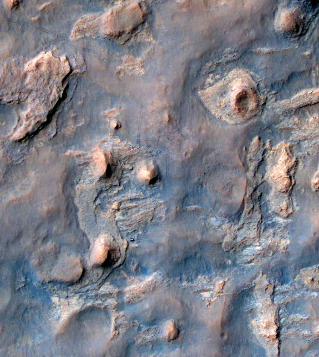
On Wednesday April 16th, NASA JPL released a remarkable image captured using the High Resolution Imaging Science Experiment (HiRISE) camera on the Mars Reconnaissance Orbiter (MRO).
The image reveals the the Mars Science Laboratory, Curiosity parked alongside the multi-layered rock formation dubbed “The Kimberley”, as it prepares to undertake a range of science studies in the area.
The image was captured by MRO on April 11th during an overflight of the rover’s position as it sits at the foot of a rocky butte mission scientists have dubbed “Mount Remarkable”, and which forms a part of a multi-layered rocky location which has been dubbed “the Kimberley” due to its resemblance to a similar confluence of rock types found in Western Australia.
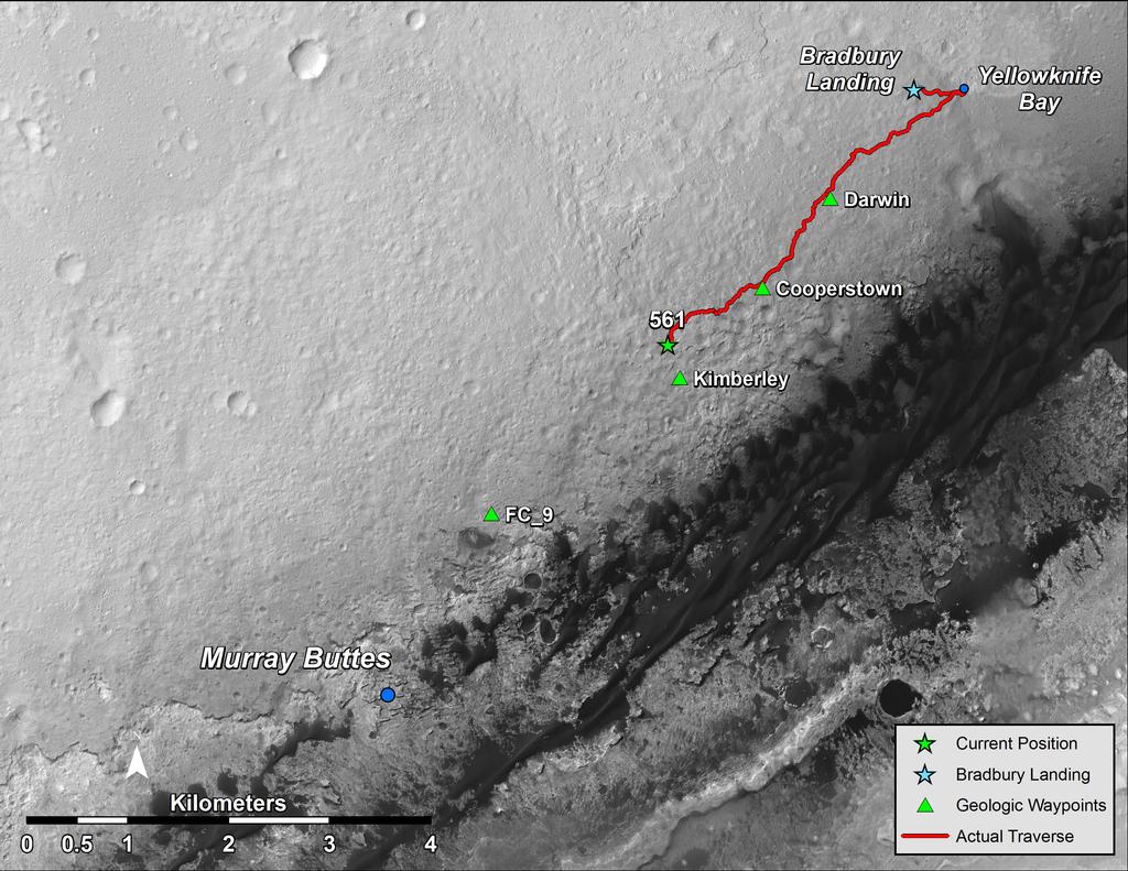
A rover’s progress: Curiosity, the blue form just off-centre in this false-colour image, sits at the foot of “Mount Remarkable”, a butte located in the area mission scientists have dubbed “the Kimberley”. the rover’s tracks can be seen leading back toward the top left corner of the image, where it entered the region on March 12th, 2014.
“The Kimberley” is an area of four distinguishable rock types exposed close together in a decipherable geological relationship to each other. As such, they should provide further clues about ancient environments that may have been favourable for life. It is of particular interest to Scientists because like “Yellowknife Bay”, where the rover spent several months analysing and drilling rocks, “the Kimberley” demonstrates features which suggest that some of the rocks have only been exposed for a short time, geologically speaking.
This matters because Mars doesn’t have a magnetosphere and thick atmosphere like Earth’s, which protect us from energetic particles from space that break down organic material. So, rocks that have been exposed or close to the surface for a very long time are less likely to contain complex organic material, which might either be the remnants of past life, or help inform scientists about past habitability, the potential to support life in an area – as was the case with “Yellowknife Bay”.
Curiosity officially reached its next planned waypoint – dubbed “the Kimberley” on Wednesday April 2nd, 2014, with a final drive of some 30 metres (98 feet), after detouring from its planned drive route to reduce the amount of wear and tear being suffered by the rover’s aluminium wheels, the result of traversing some particularly rough terrain for several months.
“The Kimberley” was identified from orbit in 2013 as a possible location of interest during the rover’s drive down towards the point at which it will start its explorations of the lower slopes of “Mount Sharp”. It is an area of four distinguishable rock types exposed close together in a decipherable geological relationship to each other. As such, they should provide further clues about ancient environments that may have been favourable for life.
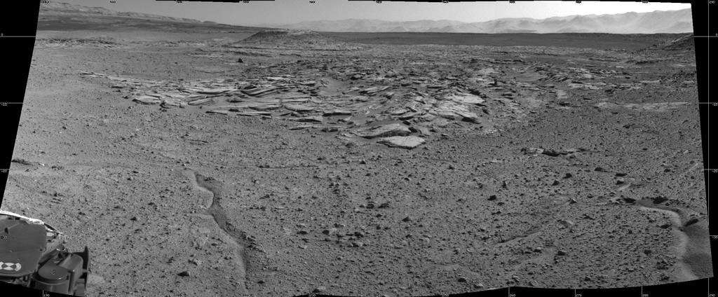
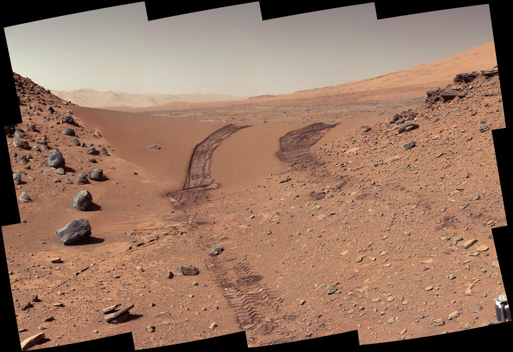
A mosaic of “The Kimberley” created by images taken by Curiosity’s Navcam on Sol 589 (April 2nd, 2013), at the conclusion of the rover’s final drive to reach the waypoint. The outcrop at the center of the image is a category that the rover team scientists call “striated,” from its appearance in images taken from orbit before the rover reached this area. Farther in the distance, the striated type is overlain by other types. On the horizon, slopes of Mount Sharp – the mission’s long-term destination – are on the left and the rim of Gale Crater is on the right (click to enlarge)
As a major waypoint, “the Kimberley” will form an extended stopover for Curiosity which, while unlikely to be as long as the 6 months the rover spent exploring and examining “Glenelg” and “Yellowknife Bay”, will still be in the order of several weeks. The first part of this work is study the area in more detail, and the location occupied by the rover and the end of its April 2nd drive – Sol 589 for the mission – is ideal for this. A slight rise compared to the surrounding terrain, it provides an excellent vantage point from which the rover can survey its surroundings, allowing mission scientists to comprehensively review the area and plan the coming science programme in finer detail than can be achieved when using orbital images alone. The science work is expected to involve observation of the surrounding region, sample-gathering from the rock formations, and onboard analysis of the samples gathered.
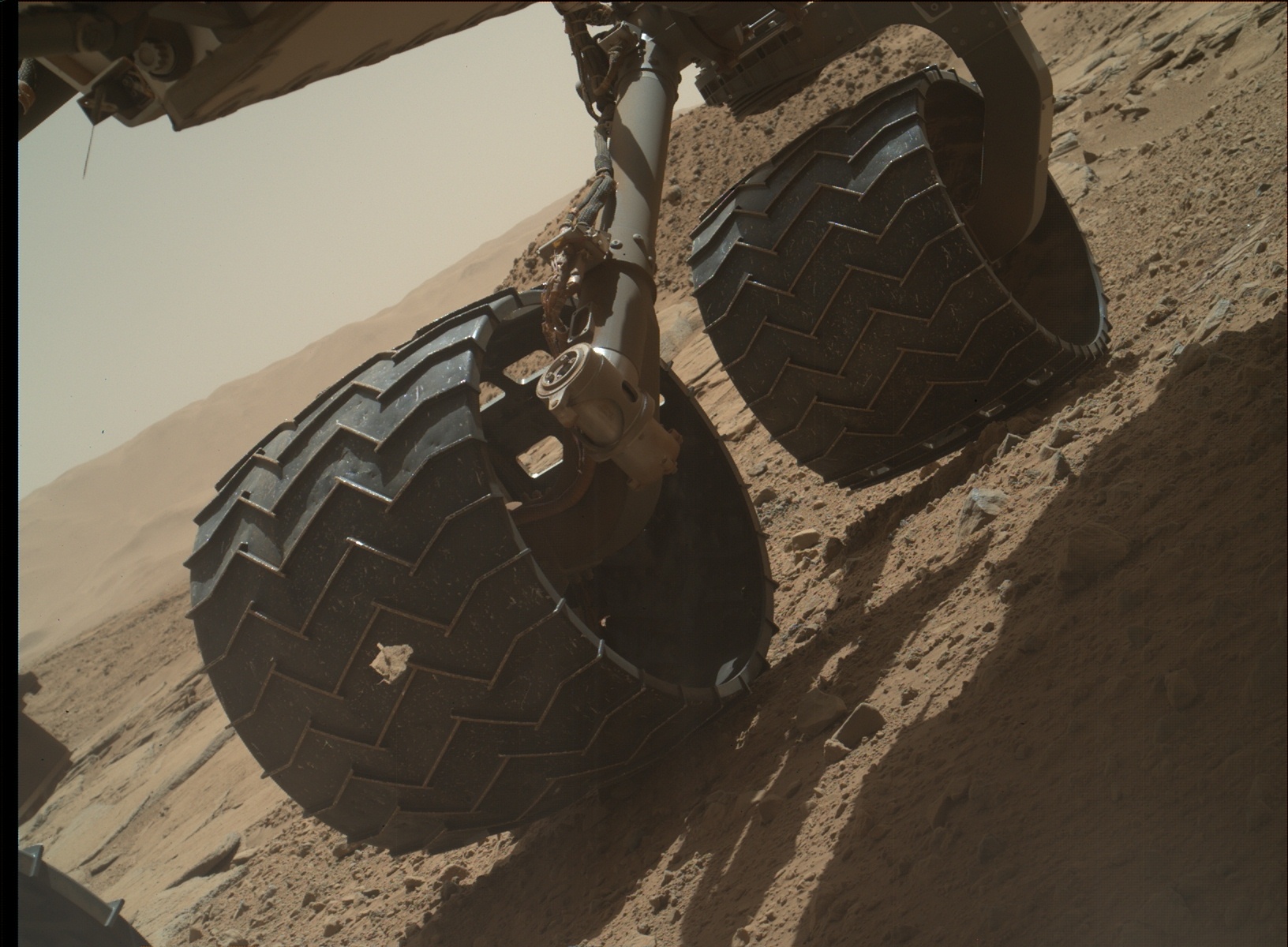
As I’ve previously reported, a cause of concern for mission personnel of late has been the amount of wear and tear the rover’s six aluminium wheels have suffered during the drive south from “Yellowknife Bay”. While the matter is far from serious in terms of impeding the rover’s manoeuvring or driving capabilities, with Curiosity’s nuclear battery offering the chance for a mission as much as 20 years in duration barring unforeseen circumstances, and what might provide to be a punishing climb up into the slopes of “Mount Sharp” still to come, the rover was directed onto less harsh terrain – comparatively speaking – in February 2014. Since then the mission team have been periodically checking on the wheels for further signs of damage and, as I noted last time around, the wear on the wheels is now around a tenth of that which had been experienced prior to the diversion. Nevertheless checks are still being carried out – including during the period in which this report was being written, as demonstrated by the raw image below, taken directly from the NASA image archive for Curiosity.
An image of one set of Curiosity’s rear wheels captured by the Mars Hand Lens Imager (MAHLI), located on the turret at the end of the rover’s robotic arm, on Sol 595 (April 9th, 2014). Note the jagged hole punched through the 40-cm (16-in) wheel (the rounded holes visible on the far side of the wheel are not signs of damage, but a part o the morse code for “JPL” deliberately cut-in to the wheels to help measure wheel rotation and slippage. This is a raw image, as posted by NASA on receipt from Curiosity, and without any white-balance post-processing (click for full size)
Mars at opposition: The bright orange disk towards the centre of this image, just above the horizon is Mars, as captured by photographer Jimmy Westlake (click for full size)
Regular readers of this blog know I have something of a passing interest in space exploration and astronomy. I’ve been covering the Mars Science Laboratory mission since its arrival on Mars, and have also covered other space / astronomy related events and occurrences.
In keeping with this, I thought I’d mention two astronomical events of some interest which occur over the next two weeks. Neither of them is exactly rare, but if you’re lucky enough to be in the Americas, you’ll get to enjoy both at the same time – and a little bit more.
The first of these is the upcoming opposition with Mars, the time at which the Red Planet is at its closest to Earth. Oppositions happen around once every 26 months, and are so-called because they mark the time when the Sun and Mars are on opposite sides of the Earth to one another. During periods of opposition, Mars can appear as one of the brightest objects in the night sky and can come within 100 million kilometres of Earth.
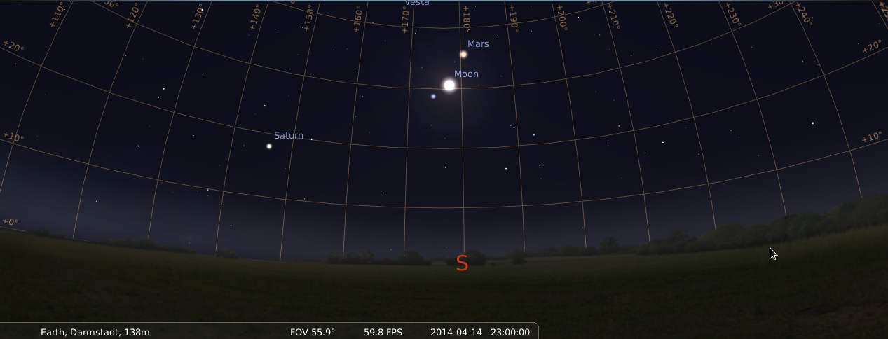
Mars on the 15th April at approx 02:00 BST / 03:00 CET (21:00 EDT of the 14th April), and making its closest approach to Earth in six and a half years, will be clearly visible in the constellation of Virgo, along with the Moon and Spica (image: ESA) – click for full size
This year, Mars will reach opposition with the Earth on Tuesday April 8th, when it, the Earth and the Sun will be aligned in an almost straight line. However, because of the nature of the orbits of the two planets, they will not reach their point of closest approach to one another until the night of Monday April 14th / Tuesday 15th, 2014. At that time, they’ll be just 92 million kilometres (57.5 million miles) apart – the closest their respective orbits have brought them to one another at opposition for six and a half years.
During April, Mars appears as a bright red “star” in the constellation of Virgo. At the period of opposition, it will be just above and to the right of the Moon, with Spica, the brightest start in Virgo, to the lower left of the Moon.
To mark this year’s opposition, NASA has produced a nice little video explaining matters some more.
As mentioned towards the top of this article, this year’s opposition is only half the story. This is because the night of closest approach is also the night of a total lunar eclipse which should be visible from almost all of North America and significant parts of South America, with the majority of USA in particular getting a front-row seat.
Things will get underway at around 23:00 PST (02:00 EDT) on the night of the Monday 14th / Tuesday 15th April, when the Moon enters partial eclipse. Totality will be reached just after midnight PST (03:00 EDT). At this point those under the path of the eclipse should witness a “blood moon” in all its glory, flanked on either side by Spica and Mars.
A lunar eclipse “blood moon” seen Idaho, December 2011 (image: Matt Mills / Reuters) – click for full size
“Blood moon” is the term sometimes applied to a total eclipse as a result of the Moon appearing to turn orange-red in colour, the hue slowly intensifying as the eclipse progresses until it reaches a bloody colour during the period of totality (about an hour and a half), before fading once more. This change in colour is the result of the Sun’s light passing through the Earth’s atmosphere as our planet moves between the Sun and the Moon, and then shining on the face of the Moon. A paler colouration of this kind can also be seen across at least a part of the Moon’s face during a partial lunar eclipse.
A total lunar eclipse and the gradual change in the Moon’s colour as seen from Earth which sees total lunar eclipses sometimes referred to as “blood moons” – the result of sunlight passing through the Earth’s atmosphere and striking the Moon’s surface (animation: Wikipedia)
The eclipse is certainly something that should generate opportunities for some stunning photographs, particularly given the positions of Mars and Spica (itself the 15th brightest star in the night sky, and a close binary star).
And that’s not all; April 15th actually marks the first of a total of four consecutive total lunar eclipses – referred to as a tetrad, all of which can be observed from North America, and which occur at roughly 6 month intervals to one another, the rest being October 8th, 2014, April 4th, 2015 and the last on September 28th, 2015.
NASA has also produced a video on the upcoming eclipse and the phenomena known as tetrads.
Some have pointed to this tetrad as marking the start of the end times, because the phenomena are supposedly “rare”, and this particular one commences on Passover.
However, while there can be long periods of time between occurrences of tetrads, they can also pop-up relatively frequently. For example, this century will see a total of nine tetrads occur, the first having taken place in 2003/4. Nor is the fact that the upcoming tetrad occurs on Passover particularly unusual; there have been eight tetrads so far coinciding with Passover since the first century AD.
So, if you’re in a position to be able to do so on the night of the 14th / 15th April, ignore the doom merchants and go outside and enjoy the night sky view!
It’s been a quiet time for the last three weeks as far as news from NASA’s Mars Science Laboratory is concerned. There have been a couple of reasons for this.
The primary reason is that the rover is on a slow but steady drive towards its next intended science waypoint while en route to the lower slopes of “Mount Sharp”. At the start of February, that waypoint had been around half a kilometre from the rover. However, concerns over the amount of wear and tear being suffered by the rover’s wheels as a result of traversing very rough terrain meant that Curiositytook a diversion.
While this put the rover on much smoother – comparatively speaking – terrain, it also meant the route to the waypoint had become more circuitous, requiring Curiosity cover around a kilometre in order to reach its intended stopover. In addition, engineers have been periodically checking the amount of damage to the wheel which may be accruing, further slowing daily progress, as well as continuing to test alternative driving methods to further ease the load on the wheels – such as letting the rover drive backwards towards its destination. However, the good news is that in the month since crossing Dingo Gap on February 18th, wear on Curiosity’s wheels has been around one-tenth what had been experienced per month during the months traversing the rougher terrain.
The long drive south. Murray Buttes mark the point at which Curiosity is expected to start the traverse onto the lower slopes of “Mount Sharp”, which forms a natural break in a line of dark sand dunes between the rover and the mound. “Kimberley” marks the next stop on the way (click for full size)
Additional tests using Curiosity’s test bed “twin” on Earth have revealed that the rover could sustain substantially more damage than incurred so far, including breaks in the wheel treads themselves, and still remain operational. However, given the potential duration of the mission – Curiosity’s nuclear “battery” could provide it with an operational life measured in a couple of decades barring other failures – means caution is key at this stage of the mission.
“The wheel damage rate appears to have levelled off, thanks to a combination of route selection and careful driving,” said JPL’s Richard Rainen, mechanical engineering team leader for Curiosity. “We’re optimistic that we’re doing OK now, though we know there will be challenging terrain to cross in the future.”
MRO Computer Glitch
The other break in news, although brief in nature, was caused by an unexpected issue with Curiosity’s primary communications relay between itself and Earth – the Mars Reconnaissance Orbiter (MRO) unexpectedly switched itself into a “safe” operating mode on Sunday March 9th. This immediately brought a cessation in the orbiter’s communications relay function for both Curiosity and Opportunity on the surface of the planet, although it did not put either rover entirely out of communications with Earth.
An artist’s impression of the Mars Reconnaissance Orbiter orbiting the planet
While MRO forms the primary means of communications between the surface of Mars and mission control at NASA’s Jet Propulsion Laboratory facility at the California Institute of Technology, the rovers on Mars can also use NASA’s Mars Odyssey as a relay – and, should it be required, Europe’s Mars Express. However, Mars Odyssey, which has been operating around Mars for almost twelve and a half years, has much lower bandwidth and data transmission rates compared to MRO, which reduces the amount of information which can be relayed to Earth at any given time.
MRO’s issue first became apparent on March 9th, when the orbiter performed an unplanned swap between its duplicate computer systems. This is the prescribed response by a spacecraft when it detects conditions outside the range of normal expectations; the safe mode is initiated to reduce the risk of whatever caused the out-of-range event from being repeated by the second computer and potentially permanently harming the vehicle while matters are investigated. MRO has experienced unplanned computer swaps triggering safe-mode entry four times previously, most recently in November 2011, the root cause of which still hasn’t been clearly determined.
The March 9th safe mode entry also included a swap to a redundant radio transponder on the orbiter, marking the first time this has happened during the vehicle’s eight years in orbit around Mars. Whether or not the transponder issue triggered the computer swap-out is unclear. However, after carrying out a series of diagnostics on MRO from Earth, the mission team began bringing the orbiter back-up to full operational capabilities on March 11th, leaving it operating on the computer the swap-out switched to, together with the previously redundant radio transponder.
“The spacecraft is healthy, in communication and fully powered,” Mars Reconnaissance Orbiter Project Manager Dan Johnston said on March 11th. “We have stepped up the communication data rate, and we plan to have the spacecraft back to full operations within a few days.”
Charting a New Frost Channel
Since that event, MRO mission scientists have released a photo comparison showing the active nature of the Martian environment. The image shows two pictures of the same slope in the wall of crater Terra Sirenum, located in the southern highlands of Mars. There were captured some two and a half years apart (roughly equivalent to 1.2 Martian years), in November 2010 and May 2013 respectively.
Side-by-side: an image of Terra Sirenum crater walls taken in November 2010 compared with an image of the same region taken in May 2013, complete with freshly carved gully and outflow fan (light areas)
The right-hand (May 2013) clearly shows the creation of a new gully down the inner wall of the crater, created when material flowing down the older channel broke out to form a new channel and corresponding fantail deposit. While the material responsible for the new gully was liquid in nature, as the event occurred in the Martian winter period in the southern hemisphere, it is believed that carbon dioxide ice, and not water, played the major role in forming the new channel.
NASA had previously experimented with dry ice to see if it could be responsible for such gullies, with interesting results.
Curiosity is once more moving forwards – by going backwards.
Since crossing the “Dingo Gap” sand dune, the rover has been on terrain dubbed “Moonlight Valley” which is far smoother than has been encountered in recent travels, exactly as the mission team would hope would be the case. Nevertheless, precautionary measures are still being used to offer Curiosity’s aluminium wheels some additional relief after a routine inspection of them revealed some had suffered much greater wear and tear than had been anticipated crossing some very rugged terrain.
While the damage to the wheels is not an immediate threat to the rover, mission planners were aware it could happen, and so have been considering various alternatives to minimise further undue wear. One of these alternatives involves the rover proceeding by driving backwards.
A white-balanced look back at the “Dingo Gap” sand dune Curiosity drove over on February 9th (Sol 538) to reach smoother driving terrain. For scale, the distance between the parallel wheel tracks is about 2.7 metres (9 feet) across (click to enlarge)
Theoretically, the design of the rover means that it can make forward progress either by driving with its front end (mounting the robot arm and science turret), or with its rear end, the large RTG cooling system, facing the direction of travel. However, the technique has never been fully tested on Mars, only having being tried over any significant distance using Curiosity’s Earth-based test bed twin; but with much smoother terrain now before the rover, mission managers were eager to discover how well Curiosity could drive when travelling backwards.
“We wanted to have backwards driving in our validated toolkit because there will be parts of our route that will be more challenging,” said mission Project Manager Jim Erickson at NASA’s Jet Propulsion Laboratory, Pasadena, California. To this end, on Tuesday February 18th, Sol 647 of the mission, Curiosity covered just over 100 metres (329 feet) whilst driving backwards, a traverse which was also the first long trek the rover has made in more than three months, bringing the total distance it has driven since arriving on Mars in August 2012 to some 5.21 kilometres (3.24 miles).
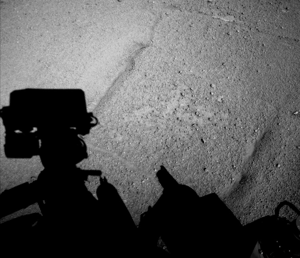
Casting a long shadow: a black-and-white Navcam image captured by Curiosity at the end of its 100-metre reverse drive on Sol 547 (February 18th, 2014). The linear markings near the rover’s shadow are not wheel marks but surface patterns in the ground over which it is travelling (click to enlarge)
With the reverse driving now proven, Curiosity is set to resume its primary mission, which will see it make its way to an area previously referred to as “KMS-9”, comprising three different terrain / rock types offer a relatively dust-free area, and which has now been renamed “Kimberley” after a region in north-western Australia noted for its ancient, exposed rocks.
Following the February 18th drive, Curiosity faced a 1.1 kilometre curving trek to reach “Kimberley”. Once there, the rover will stop there to conduct further science activities, including gathering further rock samples using the turret-mounted drill. At the same time, mission managers will use orbital imagery to select the preferred route the rover will be instructed to take in order to continue onwards to its primary destination: the lower slopes of “Mount Sharp”.
“We have changed our focus to look at the big picture for getting to the slopes of Mount Sharp, assessing different potential routes and different entry points to the destination area,” Erickson said, commenting on the need to reassess the route. “No route will be perfect; we need to figure out the best of the imperfect ones.”
Reaching Kimberley: the white line marks Curiosity’s route. Prior to cross “Dingo Gap” (top right), the rover’s route would have been more-or-less directly to “Kimberley” (lower left). Since crossing the dune onto smoother terrain, the rover has travelled some 100 metres (to “547”), with the yellow line showing the revised route to “Kimberley” the rover will be negotiating (click to enlarge)
It is not clear how long the rover will remain at “Kimberley” once it arrives there; part of this decision will likely only be made once the rover have been able to survey the area for itself.
Last time around, I mentioned that the Curiosity team was looking at alternative routes to get the rover down to the crossing-point for the start of its explorations of “Mount Sharp” at the centre of Gale Crater and, more immediately, to a target of interest for further science studies.
The desire to seek alternative routes came as a result of periodic examinations of Curiosity’s aluminium wheels revealing they’d suffered more wear and tear during recent traverses of very rough terrain than had been anticipated. While not a threat to the rover, mission managers would still prefer to lessen the impact of the rover’s southerly transit over what has proven exceptionally rugged ground.
At the time of writing that last update, planners were considering taking Curiosity over a sand dune roughly a metre (3 feet) in height sitting between two rocky scarps, as the terrain beyond the dune, dubbed “Dingo Gap”, appeared to be markedly less rough. While a little more circuitous than a direct-line drive, crossing the dune would still allow the rover to get to its next target for taking samples, a rocky outcrop dubbed “KMS-9″.
The view over “Dingo Gap”, captured on Sol 528 (January 30th, 2014), shows a westward-leading valley of much smoother terrain compared to the rover’s recent drives. The largest of the dark rocks on the sand to the right of the scene are about 60 cm (2 feet) across. This image was captured via Curiosity’s Mastcam and is shown unprocessed: the colours are as the human eye would see them on Mars under local daylight conditions (click to enlarge)
While other routes were under consideration as well, it was decided to take Curiosity “Dingo Gap” after it had been ordered to drive up to the base of the dune and take a peep directly over the top of the mound to get a detailed view of the land on the other side. The rover actually made the crossing on Sol 535 (February 6th), and a series of nine black-and-white images captured by the rear hazard-avoidance cameras (Hazcams) were later strung together to form a short video of the crossing.
series of nine images captured by the rover’s rear Hazcams show progress over “Dingo Gap”. At the start of the sequence, Curiosity’s front wheels were on the base of the dune’s slope, and the entire traverse covered a distance of some 7 metres (23 feet) – click to enlarge
With the crossing made, Curiosity is set to travel to “KMS-9”, something over half a kilometre away, and which comprises three different terrain / rock types offer a relatively dust-free area for examination and further drilling operations. The area is one of the number of potential “waypoints” identified from orbit that missions scientists hope will help provide greater insight in the soil, rock and climatic conditions which may have once existed around “Mount Sharp” and help build up a clearer picture of changes in conditions which may have occurred within the region through which the rover is travelling.
 On Wednesday April 16th, NASA JPL released a remarkable image captured using the High Resolution Imaging Science Experiment (HiRISE) camera on the Mars Reconnaissance Orbiter (MRO).