Solar conjunction: when Earth (r) is on the opposite side of the Sun or another solar system body – in this case, Mars (l)
Solar Conjunction
June sees Mars an Earth move into a period of solar conjunction, when they are one opposite sides of the Sun relative to one another. These periods of conjunction occur roughly every 26 months (the last having been April 2013), can see communications between Earth and vehicles operating on and around Mars severely disrupted due to interference from the Sun.
To prevent spacecraft at Mars from receiving garbled commands that could be misinterpreted or even harmful, the operators of Mars orbiters and rovers temporarily stop sending any commands. At the same time, communications from the craft to Earth are also stepped down, and science operations scaled back. Nasa started to do this on Sunday, June 7th, and both ESA and the Indian Space Research Organisation will be doing the same. For the two Mars rovers, Opportunity and Curiosity, it means parking up and no driving until after full communications are restored. General science observation will, however, continue.
One slight difference in all this will be with NASA’s newest orbiter at Mars: MAVEN (Mars Atmosphere and Volatile Evolution). This arrived over Mars in September 2014, with the primary mission of determining the history of the loss of atmospheric gases to space and gain insight into Martian climate evolution. As such, MAVEN will continue monitoring the solar wind reaching Mars and making other measurements. The reading will be stored within the orbiter’s memory system and transmitted back to Earth once normal communications have been restored.
MOM Studies Mars’ Volcanoes
Mars: The north polar ice cap, the three massive craters of the Tharsis volcanoes forming a near-vertical line in the centre, the mighty “boil” of Olympus Mons to their left and the 5,000 km long Vallis Marineris to their right (image courtesy of ISRO)
Another mission that hasn’t gained much attention since also arriving in orbit around Mars is India’s Mangalyaan (“Mars-craft”) vehicle, which reached Mars on September 24th, 2014. Referred to simply as the Mars Oribiter Mission (MOM) by most, the vehicle reached Mars just 2 days after NASA’s MAVEN orbiter, and like that craft, a part of its mission is focused on studying the Martian atmosphere.
MOM also carries a high-resolution surface imaging camera, and this has been busy returning some magnificent picture of Mars, including the brilliant picture of the planet reproduced above, which shows the north polar ice cap, the almost vertical line of the three massive Tharsis Bulge volcanoes of Ascraeus Mons, Pavonis Mons and Arsia Mons in the centre, the massive rise of Olympus Mons, the largest volcano in the solar system to their left, and the 5,000 kilometre scar of the massive Vallis Marineris to their right.
MOM’s camera is also capable of producing 3D images, and an example of this capability was released by ISRO on June 5th in the form of a dazzling image of Arsia Mons, the southernmost of the equator spanning Tharsis volcanoes. The image was actually captured on April 1st, 2015, and has a spatial resolution of 556 metres, and the camera some 10,707 kilometres from the surface of Mars when the picture was taken.
The mighty Arsia Mons on Mars, largest of the three Tharsis Bulge volcanoes. The image shows a deliberate vertical exaggeration to the volcano’s slope (image courtesy of ISRO)
To give some idea of the scale of this massive shield volcano, it is 435 kilometres (270 mi) in diameter at its base, rises some 20 kilometres (12 miles) in height compared to the mean surface elevation of the planet, and is some 9 kilometres (5.6 miles) higher than the plains on which it sits. The caldera crater at its summit is 110 km (72 miles) across.
In December 2014, I wrote about the Curiosity science team reporting they had detected odd “spikes” in methane levels in the Martian atmosphere as a result of analyses undertaken by the SAM (Sample Analysis at Mars) mini laboratory within the Mars rover.
Methane had first been definitively detected on Mars by the 2008 Phoenix Lander, although its presence had long been suspected and indicated. However, Curiosity’s discovery of two sudden sharp increases in the normal levels of traceable methane to some 7 part per billion – a ten time increase of the expected levels – suggested it had perhaps happened across some localised methane-producing source, possibly of organic nature (notes that “organic” in this case doesn’t actually mean “living things”).
However, the results have recently had some doubt cast upon them, and from within NASA itself. Kevin Zahnle, a scientist at NASA’s Ames Research Centre in California has been studying the data and suggested that the methane spikes could have come from a very localised source – a leaf of Earthly air previously trapped somewhere in the rover’s insides.
Could a small pocket of air carried from Earth have leaked into one of the spectrometers aboard Curiosity’s SAM instrument and caused spurious methane counts? Image: NASA / JPL
Depsite rigorous decontamination processes prior to launch, is is possible for air and gas pockets to get trapped inside a robot vehicle. This is actually what happened at the start of Curiosity’s sojourn on Mars: during its initial analysis of the atmosphere around it, the rover also detected abnormally high levels of methane, only for it to be tracked back to tiny amount of air carried aboard the rover leaking into the spectrometer carrying out the methane measurements. Zahnle suggests that a similar leak cannot yet be ruled-out as the cause of the 2013 and 2014 spikes.
Members of the Curiosity science team argue that as a result of the initial leak, they have taken every caution to prevent being misled again, and are confident that only the most exceptional of circumstances could result in SAM’s findings being the result of methane “trapped” somewhere inside the rover only get released well over a year after its arrival on Mars. However, they also admit that the potential for such a situation cannot be entirely ruled-out.
One of the arguments for the spikes being the result of contamination from within the rover is that similar readings haven’t since been recorded. A counter argument to this is that the levels SAM recorded could be the result of a yet-to-be-understood seasonal phenomena. To this end, the rover is going to be sniffing the air around it very carefully during late 2015 / early 2016 to see if it can detect any similar spikes.
Insight (in) to Mars
An artist’s impression of InSight on Mars. Image: NASA / JPL
NASA’s next mission to Mars is scheduled to launch a March 2016. In keeping with the agency’s (roughly) alternating approach to surface mission to the planet, which switch between landers craft and rovers, the InSight (Interior Exploration using Seismic Investigations, Geodesy and Heat Transport) mission is a lander mission.
As the full version of its name suggests, InSight is intended to probe the deep interior of Mars. In doing so, it is hoped the mission will not only add to our understanding of Mars, but also our understanding of the processes that shaped the rocky planets of the inner solar system (including Earth) more than four billion years ago.
Following its launch, InSight will cruise to Mars in a flight of roughly 6 months, landing on the surface in September of that year. After a check-out and calibration period, the science mission will commence in October 2016, with the overall surface mission expected to last 700 Sols (roughly 720 Earth days).
The solar arrays on NASA’s InSight lander are deployed in this test inside a clean room at Lockheed Martin Space Systems, Denver. This configuration is how the spacecraft will look on the surface of Mars.Image: NASA / JPL / Lockheed Martin
The reason Mars is being used in this way, rather than scientists simply studying the Earth to better understand the processes involved in shaping the rocky worlds of the solar system is that Mars are far less geologically active than Earth, it retains a more complete record of its history in its own basic planetary building blocks: its core, mantle and crust than does Earth.
The Lander for the mission is based on the successful design of the 2008 Phoenix mission, and will include technology and instruments that will be deployed onto the surface of Mars, including the HP3 “mole” which will burrow its way deep below the surface (see the artist’s impression under the headline to this piece) in an attempt to more accurately measure the amount of heat flowing outwards from the planet’s core.
Since my last Space Sunday update, NASA’s Curiosity rover on Mars has experienced successes to overcome some setbacks, major and minor.
The major success came in the form of what amounts to “corrective eye treatment” for the rover’s famous laser system, which has been zapping rocks and soil hundreds of thousands of times in order to analyse the resultant plasma, and thus understand the chemical and mineral composition of the target material.
Called ChemCam, the Chemistry and Camera instrument, actually comprises a laser system and a telescope / camera connected to a spectrograph. The laser is in fact two systems in one, a primary laser, used to “shoot” targets and generate the plasma, and a smaller rangefinder laser used to accurately focus the telescope camera on the intended target. However, several months ago, this rangefinder laser suffered an unrecoverable failure.
Since that time, the ChemCam team have had to rely on taking multiple images of a target rock at multiple focal lengths in order to determine the best focal length the telescope should use when the main laser is set to fire.
The ChemCam mast element on Curiosity, showing the main telescope aperture, at the centre of which sits the laser “barrel”
The problem here is that the images had to be taken, transmitted to Earth and then assessed by a team of scientists to determine the best focal length setting for the telescope, which then had to be transmitted back to Curiosity, which then had to make the required focal adjustments. Only then could the main laser be successfully fired and accurate images for analysis obtained by the telescope. Obviously, all of this is a very protracted process compared to the rover being able to automatically focus the telescope directly.
However, as a part of a recent software upload to Curiosity, the international team responsible for ChemCam were able to install an update that has resorted Curiosity’s ability to auto-focus the ChemCam telescope. Now, instead of having to send a series of images to Earth for analysis, the rover can simply run the images taken at different focal lengths and then run them through an on-board algorithm which then selects the optimal focal length for the telescope, allowing the laser firing to proceed.
A series of test firings using the new software were carried out on Thursday, May 21st, and the results weren’t only positive – they indicated the new, software-driven auto-focus technique actually yields better quality results than the original method.
The second success for Curiosity actually has its origins provide to my last Space Sunday report. As indicated at that time, Curiosity was attempting to reach a point dubbed “Logan Pass”, an area sitting at the head of a series of shallow valleys and marked by the confluence of two different types of rock.
At the time of my last report, Curiosity had already been diverted from the original route selected for getting to the target. Images of the route revealed it in part comprised what NASA calls “polygonal sand ripples”, which can cause the rover to suffer extreme traction difficulties and wheel slippage. As a result, a decision was taken to attempt the ascent to the desired science location via slightly rougher terrain; it didn’t work out.
“Mars can be very deceptive,” said Chris Roumeliotis, Curiosity’s lead rover driver said of the attempt. “There appeared to be terrain with rockier, more consolidated characteristics directly adjacent to these ripples. So we drove around the sand ripples onto what we expected to be firmer terrain that would give Curiosity better traction. Unfortunately, this terrain turned out to be unconsolidated material too, which definitely surprised us and Curiosity.”
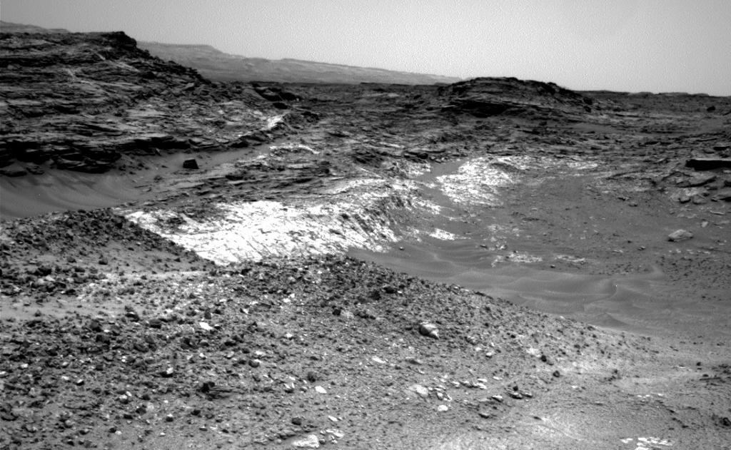
Too dangerous to drive: this Mastcam image, take by Curiosity on Sol 981 (May 10th, 2015 PDT), shows the two areas of rock the rover was attempting to reach in the middle distance (the light-coloured rock and the more grey rock above). The sand in the centre of the image had been judge too loose for a safe traverse, so the rover team had hoped to reach the target over rougher terrain, as seen to the right of this image (click for full size)
Two attempts to climb over this “unconsolidated material” (that’s loose rocks, pebble, sand, and dirt to you and me) came to an end when the rover experienced wheel slippage beyond acceptable limits, forcing the drive to stop. Coupled with indications of some sideways slippage – something the rover certainly doesn’t want to encounter lest it topple over – the decision was taken to reverse course and try an alternative route offering a way to another point at which the two rock formations meet and are both exposed.
On Thursday, May 21st, the rover successfully completed a climb up a 21-degree incline to reach a point overlooking an area where the two different strata of rock sit one atop the other, presenting an environment rich in scientific potential, and where the rover may spend some time engaged in investigations.
Rover’s reward: a Navcam image taken by Curiosity on Sol 991 (May 21st, 2015 PDT), following the large stage of a rough, steep climb. Central to the image can be seen an area of pale rock overlaid by darker material. The marks the meeting point of two different rock formations, which may give further clues as to the nature and history of “Mount Sharp’s” formation (click for full size)
NASA’s Mars Science Laboratory rover Curiosity is continuing onwards and upwards in its ascent of “Mount Sharp”, en route to a feature mission staff have dubbed “Logan Pass”. At the start of May, however, the rover made a slight detour in order to study a small valley of interest to the science team.
In planning the route up to “Logan Pass”, which sits at the head of a series of shallow valleys cut into the side of “Mount Sharp”, the rover was ordered to carry out a panoramic study of the terrain in its vicinity to help with route planning. In doing so, it imaged a small valley cut into one of the uprisings on the mound’s lower slopes, dubbed “Mount Shields”. The valley was of interest as it appeared to have been carved into the rock – possibly by liquid water action – at some point in the past and has since gradually been filled-in.
Gotcha! A view from NASA’s Mars Reconnaissance Orbiter (MRO) on April 8th, 2015 (Sol 949 for the rover), reveals Curiosity passing through the valley dubbed “Artist’s Drive” on the lower slope of “Mount Sharp”. The image was captured using MRO’s High Resolution Imaging Science Experiment (HiRISE) camera, and the rover, complete with right-pointing shadow, can be seen in the inscribed rectangle. The view in this image covers an area 500 metres (550 yards) across (click for full size)
This kind of geological feature is called an “incised valley fill”, and it is of interest because the material filling the valley cut is different to the material comprising the bedrock of the mound itself, being mostly sand. Thus the science team wanted to understand more about the possible mechanisms that might have deposited it there. Was it carried by wind or water or a mixture of both? Is there a variation in age between the rock of the mound and the material deposited in the incision? Answering these questions help in better understanding many of the environmental (geological and climatic) changes which have occurred on Mars.
Planning for the rover’s progress up the side of “Mount Sharp” is a complex process, involving multiple teams and consultations, particularly as a balance had to be achieved between reaching potential science targets and avoiding undue wear on the rover’s components and systems. To explain how the rover’s route is planned,NASA JPL recently issues a Curiosity Update video discussing the process.
Following its diversion to examine the incised valley, Curiosity resumed its upward path towards “Logan Pass”. As noted in the video, this is also of particular interest to the science team as it marks the intersection of two geological layers – the “Murray Formation”, which forms the transitional region between the slope of “Mount Sharp” proper and the floor of the Gale Crater basin, and the “washboard” region above it. It’s likely that the rover will spend some time in the “Logan Pass” are, before resuming its climb towards a further site of scientific interest, dubbed “Hematite Ridge”.
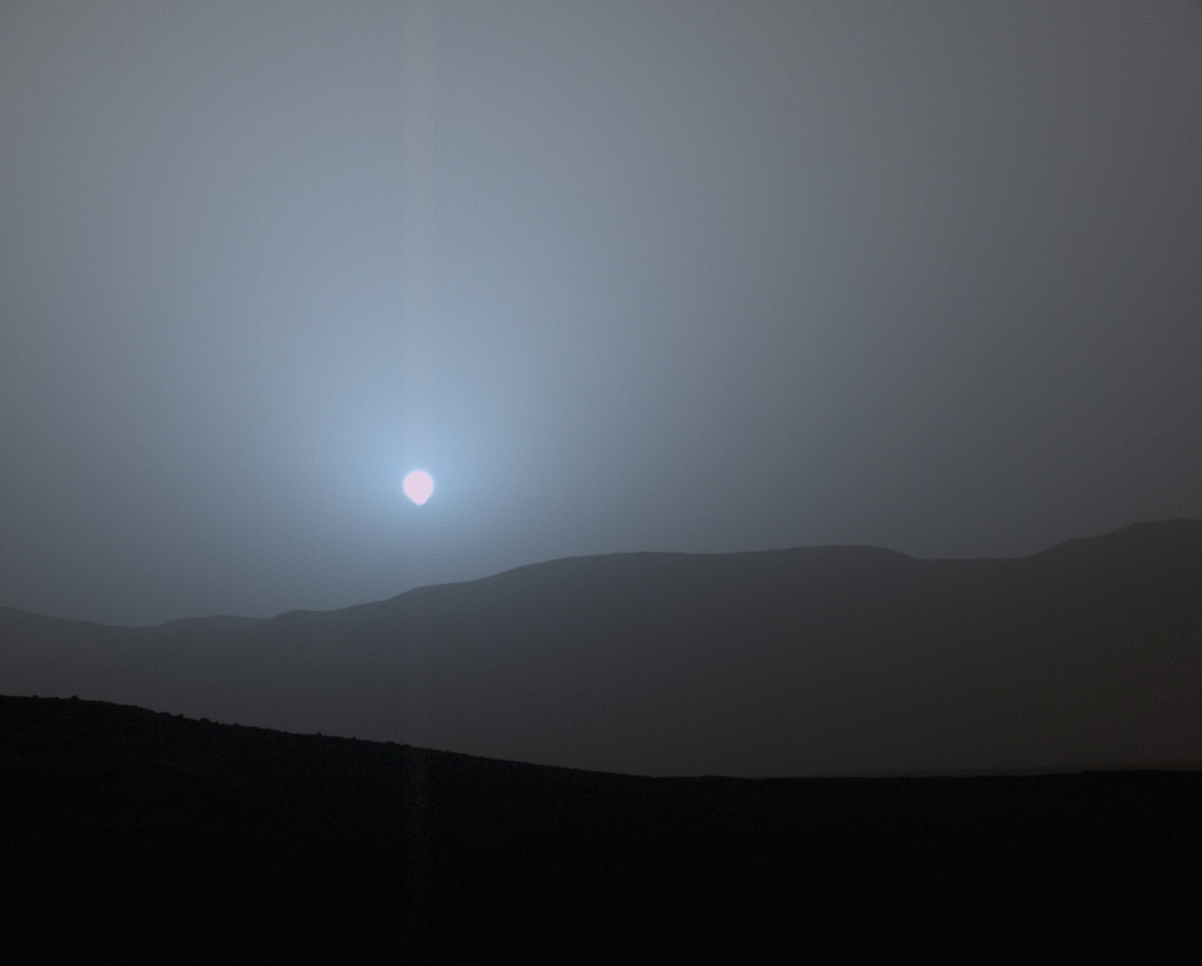
Sunset on another world: on April 15th, 2015 (Sol 956 for the rover), Curiosity captured a series of images of a setting sun as to stopped to survey the route towards “Logan Pass”. The images were captured after a dust storm had left a significant amount of particulate matter suspended in the atmosphere. Thus, the individual pictures making up this animated image allow the science team to understand the vertical distribution of dust in the Martian atmosphere and how it might influence regional climatic conditions. The blue tinting to the sky evident around the sun is due to the suspended dust particles being just the right size to allow blue wavelengths to penetrate the atmosphere with a slightly greater efficiency than other wavelengths (click for full size)
New Horizons turns Moon Hunter
New Horizons is the name of NASA’s mission to perform a high-speed flyby of the dwarf planetary system of Pluto and Charon. The craft, which achieved the fastest launch of any space vehicle to date, with an initial velocity 16.26 km/s when it lifted off the pad at Cape Canaveral Air Force Station on January 19th, 2006, is currently approaching Pluto and Charon at a relative velocity of 13.8 km/s.
Currently, the mission is closing on the period the mission team have dubbed the “seven weeks of suspense” – a reference to Curiosity’s “seven minutes of terror” during the entry, descent an landing phase of that mission – as New Horizons makes its closest flyby of Pluto and Charon, coming to within 10,000 kilometres of the former on July 14th, 2015 and 27,000 kilometres of the latter.
The nuclear-powered (RTG) New Horizons – one of the fastest man-made craft ever made to date, now closing on the Pluto-Charon system
On May 15th, 2015, New Horizons’ ability to image Pluto and Charon exceeded those of the Hubble Space Telescope. While the images are still blurry – but will massively improve – they are enough to start to show surface features on Pluto, including what might be a polar ice cap.
May also saw New Horizons enter a new phase of its mission: the discovery of further moons within the system. While Charon has traditionally been regarded as Pluto’s moon since its discovery in 1978, the relative size of Charon compared to Pluto, and the fact that the barycenter of the Pluto–Charon system lies outside Pluto, technically makes them a binary dwarf planet system, with a number of tiny moons orbiting them both – and there is a chance there may be more such little moons waiting to be discovered.
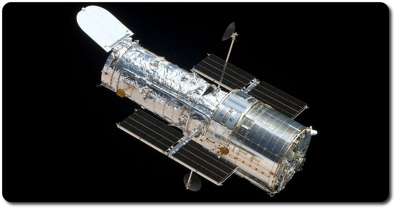
The Hubble Space Telescope (HST) as seen from the departing space shuttle Atlantis, flying STS-125, the final HST Servicing Mission, in 2009. This mission completely overhauled the space station in recognition of the fact that it is unlikely to ever be refurbished again
One of the most famous – if not the most famous – space science instruments celebrated 25 years of orbital operations in April 2015.
There can be few people with access to television or media of any description who have not at some point in their lives heard of the NASA / ESA Hubble Space Telescope. Since its launch on April 24th, 1990, and after initial teething problems which required it be fitted with the space equivalent of a pair of spectacles, the Hubble Space Telescope – also referred to as HST, or simply “Hubble” – has brought us some of the most stunning images of the planets of our solar system and deep space ever seen, giving us unique insights into the rest of the solar system, the galaxy in which we reside and the universe beyond.
The major advantage of the Hubble Space Telescope is that it operates above the distorting effect of the majority of the Earth atmosphere. Such is the benefits of such a location, that space telescopes were first proposed as early as 1923, and Hubble itself has a history stretching back as far as 1946, when astronomer Lyman Spitzer wrote Astronomical Advantages of an Extraterrestrial Observatory. For almost 20 years he continued to push the idea as the space programme came into existence until, in 1962, the US National Academy of Sciences took up the call and with three years, Spitzer had been appointed to chair a committee to define the scientific objectives for such a telescope. It was this work that gave birth to the Large Orbiting / Space Telescope in the 1970s, which became Hubble in the 1980s.
Cutaway of the Hubble Space Telescope showing the major components and sections
Named for the US astronomer Edwin Hubble, regarded as one of the most important observational cosmologists of the 20th century, the HST faced some unique challenges even before it was launched. First and foremost, in order to have as long an operational life as possible, it was designed to be serviced by astronauts, who could replace systems, fix failures, upgrade components, etc. Unfortunately, this also meant that Hubble had to be placed in a relatively low Earth orbit, resulting in further challenges.
Firstly, a low Earth orbit meant the telescope would spend half its time in bright sunlight, making observations in that part of its orbit next to impossible. It also meant an aperture door had to be fitted over the open end of the telescope, which could be closed to avoid the risk of direct sunlight falling onto the telescope’s optics and potentially damaging its science instruments.
April 25th, 1990. With its solar power panels deployed and forward aperture door closed, the space shuttle Discovery gently releases the Hubble Space Telescope at the start of its 25+ year mission
More particularly, an orbit around the Earth meant that Hubble would be passing from daylight into night every 48 minutes – and undergoing very wide swings in temperature from extremely hot to very, very cold. These not only would these cause significant heating and cooling issues for the more sensitive instruments on the telescope, they could also lead to expansion and contraction in parts of the telescope’s structure, which in turn could cause small amounts of vibration / movement when it was required to be an ultra-stable platform for space observations.
Nevertheless, despite the technical and engineering challenges the project faced, by the mid-1980s, Hubble was ready, and its launch was scheduled for October 1986. And then fate intervened, in the form of the tragic Challenger disaster of January 1986. This set back the US manned space programme by over two years, and resulted in Hubble’s launch being delayed until the 24th April 1990, when the space shuttle Discovery lifted off from Launch complex 39B at the Kennedy Space Centre on mission STS-31, and the following day successfully deployed the telescope in orbit. All seemed well with the telescope as it underwent on-orbit commissioning over the next couple of weeks; then a series of deep space test images were taken – and indicated a serious flaw in the telescope’s imaging capabilities.
Investigations were begun, and the problem was eventually traced to a error in the telescope’s primary mirror. The HST’s optics are a classic Cassegrain reflector, common to the majority of large professional telescopes, which comprises a very large primary mirror – in the case of Hubble some 2.4 metres (7 ft) across – and a smaller focusing mirror. Both have to be made to exacting tolerances through a process of grinding the reflective surfaces to their required shapes, and in the case of Hubble, the primary mirror had been ground to the wrong shape – by just 2.2 nanometres (a nanometre being one billionth of a metre).
December 8th, 1993, astronaut Kathryn C. Thornton (top of this image) holds on to the COSTAR package as the shuttle Endeavour’s robot arm slowly lifts her – and it – clear of its cradle in the shuttle’s payload bay, ready for installation into Hubble, which can be seen anchored in the shuttle’s bay behind her with the instrument bay doors open
Though tiny, the error was enough to seriously impact Hubble’s ability to carry out cosmological studies, although imaging of very bright objects (such as the planets in the solar system) was still possible. Indeed, and despite being the butt of media jokes and labelled a US $2.5 billion “white elephant”, from 1990 through 1993, Hubble still performed some remarkable work.
However, in 1993, the space shuttle Endeavour lifted-off on mission STS-61, the first of five planned Hubble Servicing Missions. While the huge primary mirror could not be repaired or replaced, the astronauts aboard Endeavour were, among a much broader series of upgrades for the telescope, able to replace one science package on the telescope with a series of corrective optics called COSTAR, and upgrade the telescope’s existing Wide Field Planetary Camera with a more refined version. Intended to counter-act the flaw in the mirror, these upgrades were the equivalent of giving Hubble a pair of glasses – and the results were spectacular.
Before and after – to images of the spiral galaxy M100, located approximately 55 million light years from Earth. On the left: an image taken by Hubble on November 27th, 1993, just before the first servicing mission. On the right, and image taken by Hubble on December 31st, 1993, after the installation of the corrective optics and camera system
Since that first operation, Hubble has been serviced four more times between 1997 and 2009, all of which have continued to keep it in good operational order, replacing things like the gyroscope packages that both keep it stable and allow it to be turned to face targets selected for observation, and have significantly updated the science packages it carries, massively increasing its research capabilities.
These missions also served a secondary purpose; while well above the bulk of the Earth’s atmosphere, Hubble still orbits within the second highest layer of the atmosphere, the thermosphere. Although exceedingly tenuous, the thermosphere nevertheless exerts minute, but cumulative drag on objects such as HST and the International Space Station, slowly reducing their orbits. To counter this, the servicing missions flown to HST allowed the space shuttle to gently “lift” Hubble back “up” to its optimal orbit.
True colour images of the star cluster Pismis 24 at the heart of nebula NGC 6357, around 8,000 light years from Earth (image: NASA / ESA and Jesœs Maz Apellÿniz, Instituto de astrofsica de Andaluca, Spain)
In the 25 years of operations, Hubble has contributed to some major scientific discoveries, assisted in resolving some major astronomical issues, witnessed some remarkable solar events, and has raised new cosmological questions. And, of course, it has brought us some of the most stunning images of our galaxy and the universe beyond it, forever changing our perception of the place in which we live.
In honour of it’s namesake, one of the primary elements of Hubble’s mission was to measure the distances to Cepheid variable stars which, because of its position in space, it could do with far greater accuracy than ever before achieved. These observations helped constrain the value of the Hubble constant, used to define the rate at which the universe is expanding (thus helping to more accurately determine the age of the universe).
Prior to HST’s work, estimates of the Hubble constant typically had errors of up to 50%; HST was able to produce measurements with an accuracy of ±10%, which have since been verified using other techniques.
As well as helping to more accurately pin down the age of the universe, Hubble also helped establish the Lambda Cold Dark Matter (“ΛCDM”) model as the “standard” model of Big Bang cosmology, by providing evidence that, rather than slowing down due to the influence of gravity (which would eventually lead to the universe contracting once more into the Big Crunch), the rate of expansion of the universe is actually accelerating, most likely due to the influence of so-called dark energy.
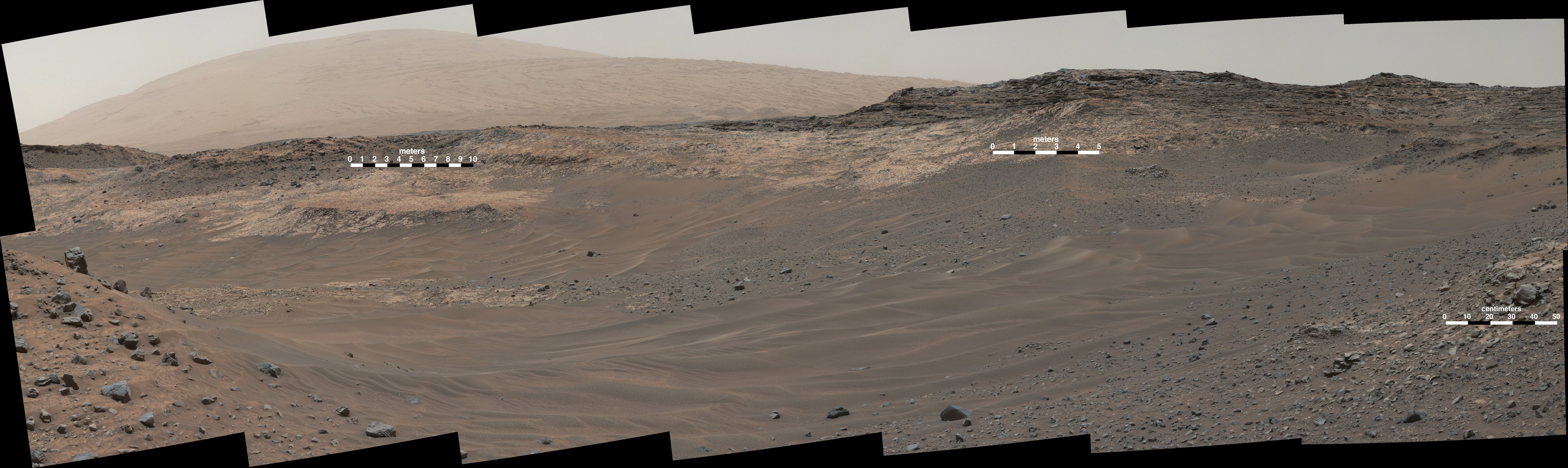
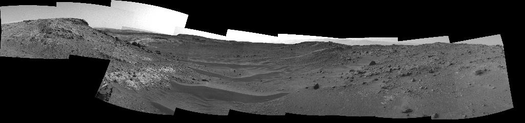
April 16th, 2015 saw NASA’s Mars Science Laboratory rover Curiosity clock-up 10 kilometres (6.25 miles) on its odometer since it arrived on Mars 30 months ago, as it continues its trek up the slopes of “Mount Sharp”, the mountain-size mound at the centre of Gale Crater.
The rover is currently making its way through a series of connected shallow “valleys” on the slops of the mound – which is more correct names Aeolis Mons – as it continues upwards and away from the “Pahrump Hills” area it spent 6 months investigating, and towards its next major science target, an area the science team have dubbed “Logan Pass”, which is still some 200 metres away from the rover at the time of writing.
While only a distance of around 550 metres separates “Logan Pass” from the upper limits of “Pahrump Hills”, the rover’s gentle progress has been the result of several stops along the way in order to further characterise the different rock types Curiosity has been encountering, and to make important observations of its surroundings as the science team try to understand the processes by which the region’s ancient environment evolved from lakes and rivers into much drier conditions.
A panoramic mosaic taken by Curiosity’s Navigation Camera (Navcam) on Sol 951 of the rover’s mission (April 10th, 2015, PDT). The view shows the terrain ahead of the rover within “Artist’s Drive”, the first of the shallow “valleys” the rover is traversing en route to the next point of scientific interest, “Logan Pass”
The rover’s progress up “Mount Sharp” has so far been through the lower reaches of the transitional layers which mark the separation points between the materials deposited over the aeons to create the gigantic mound and the material considered to be common to the crater floor. These transitional layers have been dubbed the “Murray Formation”, in honour of the late co-founder of The Planetary Society, Bruce Murray, and comprise a number of different land formations, “Pahrump Hills” being one of the lowermost. Logan Pass marks the start of another, dubbed the “Washboard unit”, and which comprises a series of high-standing buttes.
The lower slopes of “Mount Sharp” and the transitional nature of the “Murray Formation” between the create floor (left) and the “proper” slopes of the mound, marked by the “Hematite Ridge” (right). currently, the rover is now approach the lower extreme of a range of buttes within the “Murray Formation” which include “Murray Buttes” shown in the image. and which have been marked as a future science destination for Curiosity
As several of the MSL reports in these pages have shown, Curiosity has already found considerable evidence that Gale Crater may once have been home to environments sufficiently benign to allow for the existence of microbial life. Whether or not those microbes survived down the millennia such that they are still present in the planet’s soil today, is not something the rover is equipped to determine; however, a recent report from one of Curiosity’s science teams suggests that subsurface conditions are unfavourable to the support of microbial life.
The evidence for this comes in the form of perchlorate salts, and the effect they can have on their environment. Perchlorate was first detected in soil samples gathered by NASA’s Phoenix Mars Lander mission in 2008, while Curiosity found trace evidence for perchlorate in samples gathered early in its own mission.
What makes perchlorate interesting is that in cold temperatures, it is able to “pull” water vapour from the atmosphere and bind with it, lowering its temperature, potentially allowing it to form sub-surface brines which would be very destructive to microbial life.
It had been thought that the environmental conditions by which this might occur were limited to the near-polar regions of the planet. However, data gathered by Curiosity’s on-board weather station, called REMS (for Rover Environmental Monitoring Station) over the course of its mission suggests the night-time conditions in Gale Crater, are right for the formation of sub-surface brines throughout the year.