Logos representative only and should not be seen as an endorsement / preference / recommendation
Updates from the week through to Sunday, October 23rd, 2022
This summary is generally published every Monday, and is a list of SL viewer / client releases (official and TPV) made during the previous week. When reading it, please note:
It is based on my Current Viewer Releases Page, a list of all Second Life viewers and clients that are in popular use (and of which I am aware), and which are recognised as adhering to the TPV Policy. This page includes comprehensive links to download pages, blog notes, release notes, etc., as well as links to any / all reviews of specific viewers / clients made within this blog.
By its nature, this summary presented here will always be in arrears, please refer to the Current Viewer Release Page for more up-to-date information.
Note that for purposes of length, TPV test viewers, preview / beta viewers / nightly builds are generally not recorded in these summaries.
Official LL Viewers
Release viewer: version 6.6.5.575749 – formerly the Maintenance M RC viewer – promoted October 20th – NEW.
Elephant Island, October 2022 – click any image for full size
Note: For the month of October, Elephant Island is in places dressed for the Halloween season. As such, parts of the setting may appear slightly differently to some of the images in this article, having a mix of fog, mist, pirates, ghosts, fire and other mysterious elements and items.
It was off on a tropical safari for me recently, when I decided to take a trip to Elephant Island, the latest region build by Syx Toshi and his SL partner Bryn Toshi (Bryn Bulloch).
Elephant Island, October 2022
This is an extensive setting, covering three regions – a Full region and two Homesteads – all set to present the sense of a coastal setting on a mysterious island marked by a tall mountain range. The latter are formed by off-region surrounds which sit to the north of the three regions, giving them a north-south orientation along their combined length, the southern sides of the regions forming a sweeping arc of sand backed by tropical grassland, tress and high rocky bluffs.
At first glance this appears to suggest that with the broad expanse of water on their south sides, the three regions may be a short, easy exploration – but this is far from the case, as visitors quickly find out once they leave the welcome of the main landing point.
Elephant Island, October 2022
The latter sits on the eastern headland of Elephant Island’s curving bay, a small wharf extending over the waters of the beach from a makeshift fishing shack / welcome area where visitors can find maps of the local area showing trails that can offer a good starting point for explorations – although which route you take is entirely up to you.
What is clear from the outset is that the terrain here is clearly divided into two major parts. To the east the land rises sharply into rocky highlands cut through with a deep gorge. A giant elephant, carved from the living rock stands at the feet of these high bluffs, all four legs plants firmly on a table of rock as it looks out over the river mouth that opens from the gorge to flow past the landing point and its shack, emptying into the bay.
Elephant Island, October 2022
The majority of the paths shown on the maps wind up through these highlands, and one of these routes put me somewhat in mind of the giddying climb up Sigiriya, the magnificent ancient rock fortress located within the Cultural Triangle of Sri Lanka, and a place I have had the good fortune to visit half-a-dozen times when visiting that country.
In this there is little in the way of direct similarity; but the manner in which the path climbs upwards, albeit it wooden in nature rather than hewn into the rock, clinging to the sides of the rock face and winding around it and passing by natural waterfalls just put me in mind of King Kashyapa’s winter and summer palaces at the bottom and top of the rock respectively.
Elephant Island, October 2022
Unlike Sigiriya, these heights are not topped by the grounds of a former great palace, but instead are given over to more tropical woodland and grasses, home to a number of local destinations, from statues to look-out point s to zip line and bridges spanning the gorge and – for those who find it – the way into secret caverns.
Across the gorge are more climbs and walkways to be found, the hilltops crowned her by a temple devoted to the Hindu god Gnash – one of a number of shrines in his honour, and fully fitting the setting’s elephant theme.
Elephant Island, October 2022
Westward from the landing point, the bay curves through and around the two homestead regions. These are in places backed by high cliffs as the bay curls westwards, before highlands once again take over. These uplands are in part home to a private residence, the path onwards either passing to the north behind the house and its garden, or along the beach before it.
Those wishing to explore further should use the north side path in other to reach the western heights – unless a wade through water isn’t minded – to reach the western heights. These have further attractions: places to sit, another temple and so on – and its own secrets -look for the magic door. However, I’ll leave you to explore these and instead point to the Dreamd gallery. Occupying a sky platform, this offers a selection of engaging hybrid art by Byrn – a place I’ll be covering in more depth in an upcoming Art in Second Life piece.
Elephant Island, October 2022
All I’ll say for now is that with its expansive reach, wildlife, locations and general daytime ambience (you may need to set your own EEP whilst the Halloween dressing remains in place); Elephant Island is a richly engaging setting.
SLurl Details
All three of the Elephant Island regions are rated Moderate.
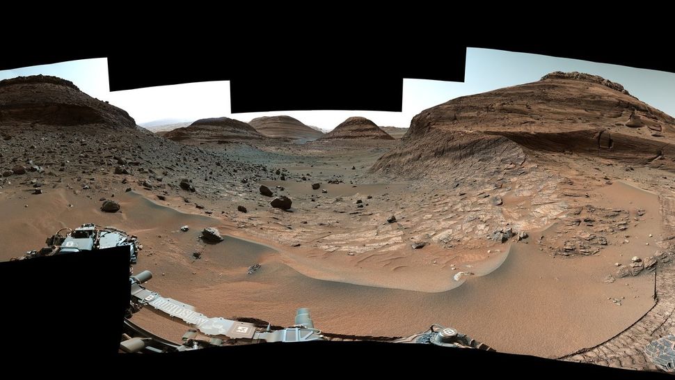
After a treacherous journey, NASA’s Curiosity Mars rover has reached an area that is thought to have formed billions of years ago when the Red Planet’s water disappeared.
Lying part-way up the slopes of “Mount Sharp”, the mound of material deposited at the centre of Gale Crater (and formally called Aeolis Mons), is rich in salty minerals scientists think were left behind when the streams and ponds on the slopes of the mound finally dried up. As such, this region could hold tantalizing clues about how the Martian climate changed from being similar to Earth’s to the frozen, barren desert we know today.
These salty minerals were first spotted from orbit by NASA’s Mars Reconnaissance Orbiter before Curiosity arrived on Mars in 2012, and that discovery marked the deposits as a prime target for the rover to examine. However, such is the rich diversity of rocks and minerals making up “Mount Sharp”, all of which have been subject to examination by the rover, it has taken the mission almost a decade to reach this “prime” target.
Even so, before Curiosity could obtain any samples from the site, the rover faced a couple of challenges.
The first lay in the fact that the rover’s position on “Mount Sharp” meant that the mission team had to drive and position the rover to ensure its antenna could remain aligned with the various orbiters it needs to use to communicate with Earth; this made navigating to the deposits a challenge, as has ensuring it can reach rocks that might yield interesting samples.
A view through “Paraitepuy Pass” captured by the MastCam on NASA’s Curiosity rover on August 14th, 2022, the 3,563rd Martian day, or sol, of the mission. Credits: NASA/JPL / MSSS
The second required further tests had to be carried out on the rover’s sample-gathering drill to ensure it would handle the stresses in cutting into the region’s rocks. As designed, the drill was intended to use a percussive action as it drilled into any target- but as I’ve reported in these pages, this hammering action started to affect the drilling mechanism as a whole, so a new algorithm was created and uploaded to the rover to minimise any use of the percussive action.
Because of this, the mission team now approach each sample gathering operation with an additional step: after scouring the surface of a sample rock to remove dust and debris, the team then position the drill bit against the rock and attempt to scratch the surface – any resultant marks would be a good indication the rock is soft enough to be drilled without the need for the hammer option.
In the case of this rock – nicknamed “Canaima” – no marks were left, indicating it might prove a difficult subject. However, a further test with the drill head turning revealed it could cut the rock without the use of the hammer action, so on October 3rd, 2022, Curiosity successfully obtained its 36th sample for on-board analysis.
A MastCam view of the 36th successful sample hole Curiosity has drilled, this one on the sulphate-rich rock dubbed “Canaima.” Inset: the hole as imaged by the Mars Hand Lens Imager (MAHlI) mounted on rover’s robot arm, along with the drill mechanism. These mages were taken on October 3rd, 2022, the mission’s 3,612th Martian day, or sol. Credits: NASA/JPL / MSSS
The route to this sulphate-rich area also required Curiosity pass through a narrow, sand-rich location dubbed “Paraitepuy Pass”, bordered on either side by slopes the rover could not drive over or along. Such is the nature of the sand the rover took over a month to traverse the pass, moving cautiously in order to avoid getting bogged-down. This meant that the rover celebrated its 10th anniversary crossing the pass.
The challenges also haven’t ended; the salty region comprises rocky terrain that is so uneven, it will be difficult for Curiosity to place all six wheels on stable ground. This isn’t a problem when on the move, but it could limit science operations in the area: if all of the rovers wheels are not in firm contact with the ground under them, operators won’t risk unfolding its instruments-loaded robot arm in case it clashes with jagged rocks.
Even so, the rover still has a lot of opportunities for science and discovery as it continues to climb “Mount Sharp”.
JWST Wows, HST, Chandra and IXPE Respond
It is now 100 days since the James Webb Space Telescope commenced operations, and in their most recent updates, NASA released a stunning image the observatory captured of the iconic Pillars of Creation.
The Pillars of Creation as imaged by the James Webb Space Telescope. Credit: NASA / ESA
Located in the Serpens constellation, roughly 6,500-7,000 light-years from Earth, the Pillars are gigantic “elephant trunks” of interstellar gas and dust, a birthplace of new stars, constantly, if slowly being changed by the very stars born within them. They were imaged by the Hubble Space Telescope (HST) in 1995, the image becoming famous the world-over despite HST imaging them again it 2014. However, the image developed by JWST’s Near Infra-red Camera (NIRCam) eclipses the Hubble image, revealing the pillars and their surroundings in incredible detail.
Newly formed stars lie outside of the column. Seen merely as a few bright red orbs with strong diffraction spikes radiating from them, they are reveal by JWST as in their truer colours – blues, yellows, whites, indicative of their spectral classes, a veritable sea of stars, These are the stars that are causing the pillars to change and collapse as a mix of their gravities and radiative energy influence their form.
The Pillars of Creation as images by the Hubble Space Telescope in visible light (1995 – left) and by the James Webb Space Telescope in the near infra-red (right – 2022). Credit: NASA / ESA
Also visible along the edge of the pillars are wavy forms, the ejections of gas and dust from stars that are still forming. The crimson glow seen within some of these wave-like forms is the result of energetic hydrogen molecules interacting with the supersonic outbursts of the still-forming stars. Within the cloudy forms of the pillar are red points of light – newly-formed stars that are just a few hundred thousand years old, the light just stars to break through the surrounding clouds of dust and material.
Around all of this is a translucent blue glow, a mix of dust and gas known as the interstellar medium, found in the densest part of our galaxy’s disk. It serves to block the view of the deeper universe, bringing the Pillars of Creation to the fore.
This new view of the Pillars will help researchers revamp their models of star formation by identifying far more precise counts of newly formed stars, along with the quantities of gas and dust in the region. Over time, they will begin to build a clearer understanding of how stars form and burst out of these dusty clouds over millions of years.


 After a treacherous journey, NASA’s Curiosity Mars rover has reached an area that is thought to have formed billions of years ago when the Red Planet’s water disappeared.