Getting set for a long drive

CuriosityAfter six months in “Yellowknife Bay”, Curiosity is getting ready to move on. Investigations in the area are due to come to an end in the near future, and with the new autonomous driving software now installed in the rover, it is anticipated that the long drive to “Mount Sharp” will begin very soon. The start of this phase of the mission will be marked by the Rover retracing its steps (tracks?) through “Glenelg”, the region so-named partially because it is a palindrome, reflecting the fact the rover would be driving through it twice.

How long the rover will take to get to “Mount Sharp” is entirely open to question, however. While Curiosity is now far more capable of autonomous navigation, it won’t be a case of “pick and route which looks good and go”. If nothing else, there is no way of knowing what the rover might discover while en route.

“We don’t know when we’ll get to Mount Sharp,” Mars Science Laboratory Project Manager Jim Erickson said at the Jet Propulsion Laboratory in Pasadena, California. “This truly is a mission of exploration, so just because our end goal is Mount Sharp doesn’t mean we’re not going to investigate interesting features along the way.”

The slopes of "Mount Sharp"
The slopes of “Mount Sharp” showing a “region of interest”  captured by Curiosity’s Mastcam in August 2012 while the rover was still at the “Bradbury Landing” site. Scientists are keen to explore the mesa-like outcrops on the side of the mound, although how long it will take the rover to get to them in subject to finding a suitable route and also upon what other discoveries lay along the rover’s path. The black dot in the inset image (actually a large rock) demonstrates how the rover might look from “Bradbury Landing” were it exploring “Mount Sharp” at the time the images was captured

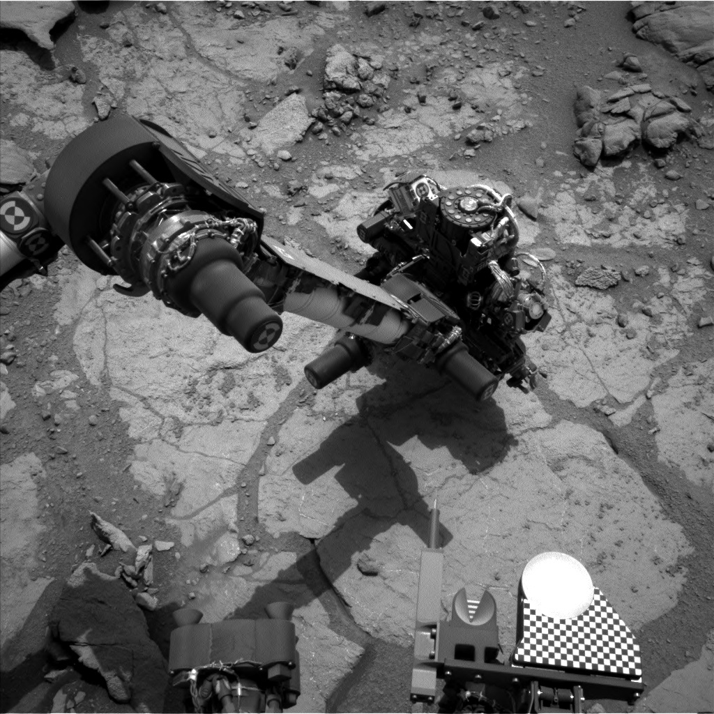
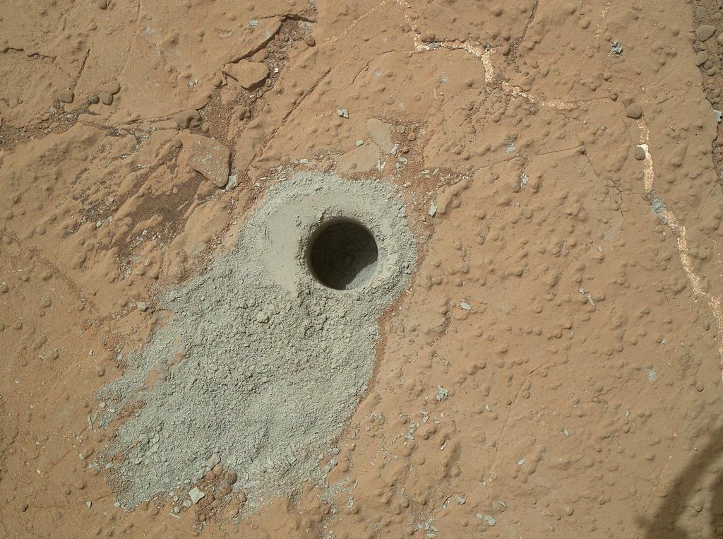
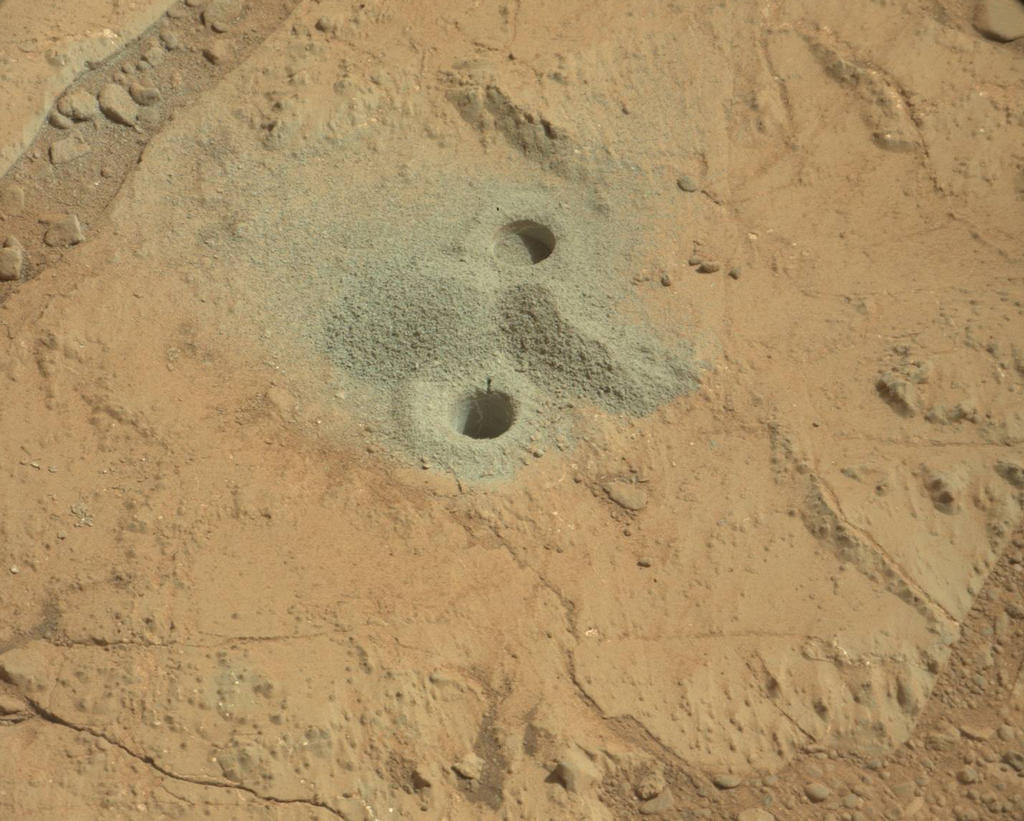
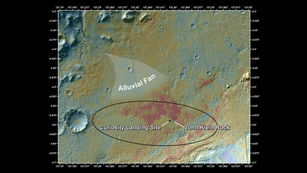
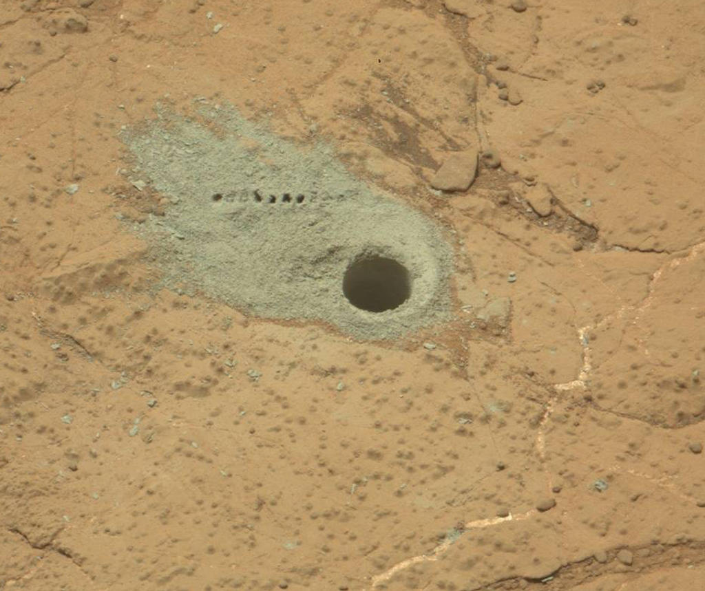
In May, Curiosity completed a second drilling operation to obtain samples from inside an area of bedrock called “Cumberland” within “Yellowknife Bay”, delivering them to the Chemistry and Minerology (CheMin) and Sample Analysis at Mars SAM) suites of instruments aboard the rover for detailed analysis. This work is still ongoing, and it is hoped that the result will further confirm findings obtained as a result of the first drilling operation, carried out a few metres away on a rock formation dubbed “John Klein”, and which suggested that the area once had environmental conditions favourable for microbial life.

No further drilling operations are now planned for the area, although NASA has yet to give word on the results from the initial analysis of the “Cumberland” cuttings.  Additionally, once the order is given to start the drive towards “Mount Sharp”, the rover will retain cuttings from the “Cumberland” drilling ins its sample scoop which can be delivered to CheMin and SAM for additional analysis, if required.

Both drilling operations have been important steps for the MSL mission. Not only have they been a successful test / use of the last remain major science capability on the rover (the ability to drill into rocks and obtain samples), they’ve also been an important learning situation for mission engineers. Steps which each took a day each to complete when drilling at “John Klein” could be strung together into a single sequence of commands at “Cumberland”, allowing the rover to complete a number of drilling-related tasks autonomously and in a single day.

“We used the experience and lessons from our first drilling campaign, as well as new cached sample capabilities, to do the second drill campaign far more efficiently,” said sampling activity lead Joe Melko of JPL. “In addition, we increased use of the rover’s autonomous self-protection. This allowed more activities to be strung together before the ground team had to check in on the rover.”

Site of the second drilling operation at “Cumberland”. The sample hole, 1.6 cm across (0.6 in) was cut on May 19th, 2013 (Sol 279). The row of small holes in the grey tailings surrounding the drill-hole mark where the Chemistry and Camera (ChemCam) laser was used to check the composition of the tailings

It’s hoped that these capabilities will allow the mission team to plan future routines for the rover more efficiently and in the knowledge that Curiosity has the ability to carry out multiple tasks without the need to “‘phone home” at each stage of an operation, something which introduces considerable delays in activities as a result of the two-way communications lag.

Prior to leaving “Yellowknife Bay”, two further “targets of opportunity” will be subject to brief observations by Curiosity. The first of these is a layered outcrop dubbed “Shaler”, which was briefly looked at as the rover initially entered the “Glenelg” / “Yellowknife Bay” region, and a pitted outcrop called “Point Lake”

The science team has chosen three targets for brief observations before Curiosity leaves the Glenelg area: the boundary between bedrock areas of mudstone and sandstone, a layered outcrop called “Shaler”, a possible river deposit, and a pitted outcrop called “Point Lake”, a depressional area thought to be either volcanic or sedimentary in nature, and which the rover observed when entering “Yellowknife Bay” from “Glenelg”.

Continue reading “Getting set for a long drive”

Cutting into “Cumberland”

CuriosityOn Sol 279 of its mission (May 19th 2013), Curiosity completely its second major drilling operation intended to retrieve cuttings from inside a rocky surface in the “Yellowknife Bay” area of Gale Crater on Mars.

The operation took place on a rocky outcrop dubbed “Cumberland” a short distance from the site of the initial drilling operation, which took place on a rocky area dubbed “John Klein” in February 2013. Samples gathered from the drilling will be processed by CHIMRA – the Collection and Handling for In-situ Martian Rock Analysis – prior to being delivered to the Chemistry and Minerology (CheMin) and Sample Analysis at Mars (SAM) instrument suites inside the body of the rover.

A “raw” (unprocessed) image returned by Curiosity’s Left B black-and-white Navcam as drilling operations are underway at “Cumberland” rock on Sol 279 (May 19th, 2013).

The primary aim of this work is to check findings gathered in the analysis of samples obtained from “John Klein”. These indicate that Yellowknife Bay long ago had environmental conditions favourable for microbial life, with conditions which included the key elemental ingredients for life, an energy gradient that could be exploited by microbes, and water that was not harshly acidic or briny.

“Cumberland” itself is very similar to “John Klein”, but has more of the erosion-resistant granules that cause the surface bumps. The bumps are concretions, or clumps of minerals, which formed when water-soaked the rock long ago. Analysis of a sample containing more material from these concretions could provide information about the variability within the rock layer that includes both “John Klein” and “Cumberland”.

Imaged by the Mars Hand Lens Imager, the hole cut into “Cumberland,” during the 279th Martian day, or Sol, of the rover’s work on Mars (May 19, 2013) cuttings collected by the drill from this hole will be delivered to the rover’s on-board CheMin and SAM instruments for analysis. The hole is some 1.6 cm across and 6.6 cm deep

The initial hole cut into “Cumberland”, which lies some 2.75 metres (9 feet) from “John Klein”, was made to a depth of 6.6 cm (2.6 inches), which was sufficient to force cuttings up into the collection bowl in the drill head itself. In the coming days the cuttings will be passed into CHIMRA and then to the rover’s sample-gathering scoop where they’ll be visually checked by the rover’s camera systems prior to being passed through the sieving mechanisms within CHIMRA ready for delivery to CheMin and SAM.

Once delivered to both instruments, analysis of the samples is liable to take a place over a few days prior to results being returned to Earth.

Related Links

Out of the glare of the Sun

CuriosityIt’s been over a month since I last reported on the Mars Science Laboratory mission on Mars. It’s not that I’d forgotten about it or lost interest in writing MSL reports; the lull has been because during the month of April, we’ve been in a period of Solar conjunction, which places Earth and Mars on opposite sides of the Sun relative to one another.

During these periods, communications between Earth and vehicles operating on and around Mars are severely disrupted / curtailed due to interference from the Sun, so NASA effectively places all of their Mars missions on “autopilot” until full communications can be re-established with them from Earth. This happened early in May, and since then, mission scientists and engineers have been running the Curiosity rover through a series of checks to confirm it is still OK after its enforced silence and also completing a complete software update.

Just prior to the moratorium on Earth / Mars communications coming into effect, Curiosity had been engaged in analysing samples obtained from drilling into a rock dubbed “John Klein” (see: Getting the scoop on drilling, and: It probably doesn’t taste like chicken …). The analysis was performed by the rover’s on-board Chemistry and Minerology (CheMin) and Sample Analysis at Mars (SAM) instruments, and produced evidence of an ancient wet environment that provided favorable conditions for microbial life, including both the elemental ingredients for life and a chemical energy gradient such as some terrestrial microbes exploit as an energy source.

Sol 229 (March 29th, 2013) The first holes drill into rock by NASA’s Mars rover Curiosity, with drill tailings around the holes plus piles of powdered rock collected from the deeper hole and later discarded after other portions of the sample had been delivered to analytical instruments inside the rover. The two holes are each 1.6 cm (0.6 in) in diameter. The shallower hole was cut on Sol 180 (Feb. 6, 2013) as a preparatory test. The deeper hole was bored on Sol 182 (Feb 8, 2013) and cuttings from this hole gathered by the drill were delivered to Curiosity’s on-board Chemistry and Mineralogy (CheMin) and Sample Analysis at Mars (SAM) instruments.

A Reduced, but Still Dynamic Atmosphere

Mars has a very thin atmosphere, so thin that the highest atmospheric density on Mars is equal to the density of the atmosphere found 35 km (22 miles) above the Earth‘s surface. However, evidence for free-flowing water having once existed on Mars suggests that the atmosphere was once very much denser. The mystery has been what happened to that atmosphere? Several theories have been put forward over the years to explain the apparent loss in atmospheric density, one of them being that over the millennia, much of Mars’ atmosphere “bled off” into space due to a combination of factors. As a result of data returned from Curiosity in March, scientists found the strongest evidence to date for this being the case.

Continue reading “Out of the glare of the Sun”

Getting back to work and an Opportunity for comparisons

CuriosityThe Mars Science Laboratory rover Curiosity resumed full science operations on March 23rd, with the delivery of a second portion of cuttings to the Sample Analysis at Mars (SAM) instruments inside the rover. Earlier, on March 21st, Curiosity resumed continuous environmental monitoring of the “Yellowknife Bay” area of Gale Crater.

Full-scale operations with the rover had been halted following the discovery of a computer glitch in the primary computer system the so-called “A-side” computer, which prompted mission controllers to order the rover to switch to the redundant “B-side” computer.

Since then, engineers and scientists on Earth have been working to both recover the “A-side” computer while simultaneously working to transfer all relevant data and command sets to the “B-side” computer and run Curiosity through a series of tests in order to ensure the “B-side” computer can increasingly take over day-to-day operations on the rover.

The “A-side” problem was traced to the unit’s memory module which acts as the “table of contents” for accessing the computer’s memory, preventing data and instructions from being accessed and causing the computer to enter into an “endless loop”. The computer has now been fully recovered and is available as a back-up once more, should it be required.

Recovery to the “B-side” computer was drawn-out due to the need for the computer to “understand” various aspects of the rover’s condition, including the placement of the robot arm, so that it could correctly take-on command and control. This involved a series of tests carried out early in March. More recently, engineers had to confirm the “engineering camera” sets, were functioning correctly.

In all, Curiosity uses some seventeen camera systems. Of these, 12 are paired sets of “engineering cameras” comprising the black-and-white Navigation Cameras (Navcams) mounted on the rover’s mast, the black-and-white front Hazard Avoidance Cameras (Hazcams) mounted at the front of the rover’s body, and the rear black-and-white Hazcams. Of these cameras, three pairs (of Navcams and front/rear Hazcams) are hard-wired to the “A-side” computer, and three pairs are hard-wired to the “B-side” computer.

The last time the “B-side” engineering cameras had been used was in April 2012, when the Mars Science Laboratory was still en route to Mars (the “B-side” computer was used to “look after” the rover and its ancilliary systems during the long flight from Earth to Mars). As the rover was switched-over to the “A-side” computer shortly after arrival on the surface of Mars, the “B-side” cameras had never been actively used on the planet, and thus needed to be run through a similar set of commissioning tests and check-outs which marked Curiosity’s initial activities back in August 2012.

Looking at Curiosity’s left-front and left-centre wheels and tread marks, using the left Navcam on the rover’s mast, which is hard-wired directly to the “B-side” computer. Captured on March 22nd, 2013, or Sol 223 of the mission, this image marks the first time the “B-side” engineering cameras have been used in more than six months – and the first time they have been used by the rover on the surface of Mars. For reference, the wheels are 50 cm (20 in) in diameter.

Bringing the “B-side” computer up to a point where it could take over all on-board operations  was further delayed when it also suffered a glitch on March 16th which, although relatively minor in scope, caused engineers on Earth to order Curiosity back into a “safe mode” of operations while the glitch was investigated, diagnosed and corrected.

Continue reading “Getting back to work and an Opportunity for comparisons”

Water, white balance, rocks and glitches

CuriosityFollowing the announcement that Curiosity had found chemical and mineral signatures pointing towards Mars – or at the very least, Gale Crater – once being wet enough to create the right conditions in which micro-organisms may have once survived, the mission team has continued to analyse data returned by the rover over the last several weeks. In doing so, they have uncovered further evidence as to role of water in area during wet periods of Mars’ past.

The most recent findings from the Mars Science Laboratory team was presented to the Lunar and Planetary Science Conference, being held in Texas, on March 18th, in which the team discussed the use of the infrared-imaging capability of the Mastcam system and the neutron-firing Dynamic Albedo of Neutrons (DAN) instrument to find further evidence of the hydration of minerals in the area.

Mastcam’s ability to capture infra-red images means it can be used as a mineral-detecting tool and as a means of observing hydration in surface rock features, where the ratio of brightness in images captured at different near-infrared wavelengths can indicate the presence of hydrated minerals. The technique was used to check rocks in the “Yellowknife Bay” area and has revealed some rock formations in the area to be crisscrossed with bright veins.

An area of the target rock “Knorr” at “Yellowknife Bay”, some 25 cm (10 inches) across, mapping the amount of mineral hydration indicated by a ratio of near-infrared reflectance intensities as detected by Curiosity’s Mastcam. The scale on the right shows the assignment of colours for relative strength of the calculated signal for hydration. The map shows that the stronger signals for hydration are associated with pale veins and light-toned nodules in the rock. This image and data were recorded on Sol 133 (Dec. 20, 2012) – click to enlarge

“With Mastcam, we see elevated hydration signals in the narrow veins that cut many of the rocks in this area,” said Melissa Rice of the California Institute of Technology, Pasadena. “These bright veins contain hydrated minerals that are different from the clay minerals in the surrounding rock matrix.” She went on to explain, “What Mastcam is seeing is water that is bound in the mineral structure of the rocks. This water is left over from a previous wet era and is now trapped and preserved in these hydrated minerals.”

The Russian-made DAN instrument on Curiosity detects hydrogen beneath the rover. At the rover’s very dry study area on Mars, the detected hydrogen is mainly in water molecules bound into minerals. “We definitely see signal variation along the traverse from the landing point to Yellowknife Bay,” said DAN Deputy Principal Investigator Maxim Litvak of the Space Research Institute, Moscow. “More water is detected at Yellowknife Bay than earlier on the route. Even within Yellowknife Bay, we see significant variation.”

Findings from the Canadian-made Alpha Particle X-ray Spectrometer (APXS) on Curiosity’s arm-mounted turret indicate that the wet environmental processes that produced clay at Yellowknife Bay did so without much change in the overall mix of chemical elements present, and confirmed the elemental composition of the outcrop Curiosity drilled into matches the composition of basalt, the most common rock-type on Mars. The APXS findings were initially affected by the dust layer common to most surfaces on Mars, which masked the basaltic signature of the rocks until the rover’s wire brush was used to scrub a section of rock clean of the dust.

“By removing the dust, we’ve got a better reading that pushes the classification toward basaltic composition,” Curiosity science team member Mariek Schmidt said. The sedimentary rocks at Yellowknife Bay likely formed when original basaltic rocks were broken into fragments, transported, re-deposited as sedimentary particles, and mineralogically altered by exposure to water.

Continue reading “Water, white balance, rocks and glitches”

Water good enough to drink

CuriosityAfter just six months on Mars, Curiosity looks to have taken a significant step towards fulfilling its primary science mission: to determine whether conditions on the planet once provided a suitable environment in which life might have arisen.

Despite recently suffering a serious computer glitch – of which more later – Curiosity’s initial analysis of cuttings gathered from inside bedrock dubbed “John Klein”, so named in honour of the late John W. Klein, MSL’s former Deputy Project Manager, and which is located in the “Yellowknife Bay” region of  Gale Crater, reveals very strong evidence that ancient Mars could have supported living microbes.

Commenting on the findings, Michael Meyer, lead scientist for NASA’s Mars Exploration Programme, said, “A fundamental question for this mission is whether Mars could have supported a habitable environment. From what we know now, the answer is yes.”

The initial findings came via the rover’s Chemistry and Mineralogy (CheMin) and Sample Analysis at Mars (SAM) instruments, which each received a portion of the rock cuttings gathered from within “John Klein” on Sol 182 (February 8th / 9th). The deliveries of the samples took place on Sols 195 (February 22nd) and 196 (February 23rd) respectively, the delay between sample gathering and delivery being down to a combination of the need to “clean” the sample holding and transfer elements of dill bit and concerns over the long-term status of a filter in part of the turret-mounted sample handling mechanism (see Getting the scoop on drilling).

The area of “Yellowknife Bay” sits at the end of what mission scientists believe to be an ancient river system, and which may have been a part of a larger lake bed in planet’s ancient past. During the drive from Bradbury Landing, where it arrived on Mars in August 2012, Curiosity has come across strong evidence for liquid having once flowed freely through the region. Rock formations commonly associated with stream and river beds have been found and imaged, and the “Yellowknife Bay” area itself bears all the hallmarks of having been formed as a result of material being carried in free-flowing liquid – most likely water. These findings have supported evidence from orbit, where images taken by various spacecraft have long pointed to large parts – if not all – of Gale Crater having been subjected to aqueous activity in the distant past. This evidence includes a broad alluvial fan of water-deposited materials located close to the landing area planned for the rover, and regarded as a valuable back-up science target should post-landing issues with the rover prevent it from undertaking the long trek up onto “Mount Sharp”.

A false colour image of the MSL landing area, showing the position of the alluvial fan of water-laden material seen from orbit and which hinted that the region had a strong aqueous past. The slopes of “Mount Sharp” can be seen in the lower right-hand corner of the image,coloured light grey (click to enlarge)

The “John Klein” bedrock itself shows strong evidence on its surface for  having been formed by aqueous activity spanning numerous wet periods in the planet’s history. However, this is not what has excited scientists – evidence for water having flowed freely on Mars has been found right across the planet, both from orbit and on the ground. During their explorations of Mars, for example, both of the Mars Exploration Rovers – Spirit (before its demise) and Opportunity – came across rock formations which had most likely been formed in the presence of liquid water.

What makes the findings returned from “Yellowknife Bay” exciting for scientists is that previously, those areas of rock thought to have been formed as a result aqueous activity also showed strong signs that the water was likely to have been highly acidic and had what is referred to as a “low energy gradient”, both of which would have made the chances of life arising within it exceptionally challenging.

Continue reading “Water good enough to drink”