Space Sunday: the sand dunes of Mars and flying to the ISS

Curiosity
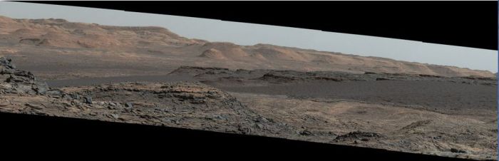
The Mars Science Laboratory rover, Curiosity, continues to climb the flank of “Mount Sharp” (formal name: Aeolis Mons), the giant mount of deposited material occupying the central region of Gale Crater around the original impact peak. For the last three weeks it has been making its way slowly towards the next point of scientific interest and a new challenge – a major field of sand dunes.

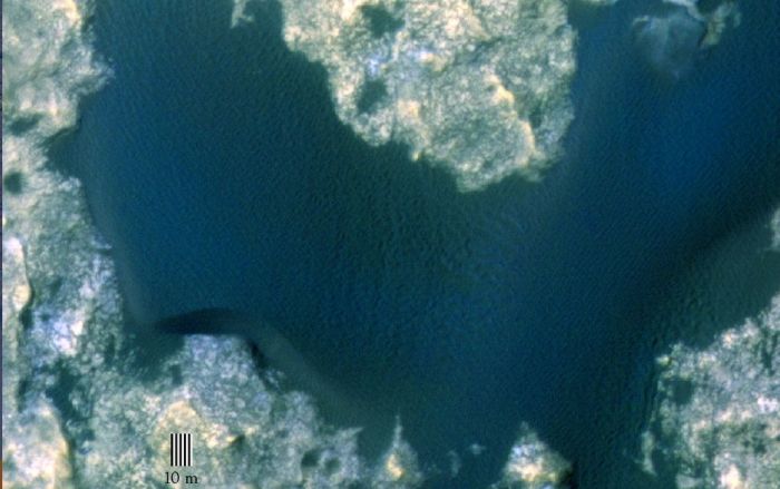
Dubbed the “Bagnold Dunes”, the field occupies a region on the north-west flank of “Mount Sharp”, and are referred to as an “active” field as they moving (“migrating” as the scientists prefer to call it) down the slops of the mound at a rate of about one metre per year as a result of both wind action and the fact they are on a slope.

Curiosity has covered about half the distance between its last area of major study and sample gathering and the first of the sand dunes, simply dubbed “Dune 1”. During the drive, the rover has been analysing the samples of rock obtained from its last two drilling excursions  and returning the data to Earth, as well as undertaking studies of the dune field itself in preparation for the upcoming excursion onto the sand-like surface.

While both Curiosity and, before it, the MER rovers Opportunity and Spirit have travelled over very small sand fields and sand ripples on Mars, those excursions have been nothing like the one on which Curiosity  is about to embark; the dunes in this field are huge. “Dune 1”, for example, roughly covers the area of an American football field and is equal in height to a 2-storey building.

"dune 1" in the "Bagnold Dunes", imaged here by the High Resolution Imaging Science Experiment (HiRISE) camera on NASA's Mars Reconnaissance Orbiter (MRO) is roughly 300 metres across and as tall as a 2-storey building. The image is in false color, combining information recorded by HiRISE in red, blue-green and infrared frequencies of light.
“dune 1” in the “Bagnold Dunes”, imaged here by the High Resolution Imaging Science Experiment (HiRISE) camera on NASA’s Mars Reconnaissance Orbiter (MRO) is roughly 300 metres across and as tall as a 2-storey building. The image is in false colour, combining information recorded by HiRISE in red, blue-green and infra-red frequencies of light.

While the rover will not actually be climbing up the dune, it will be traversing the sand-like material from which it is formed and gathering samples using the robot arm scoop. This is liable to be a cautious operation, at least until the mission team are confident about traversing parts of the dune field – when Curiosity has encountered Martian sand in the past, it has not always found favour; wheel slippage and soft surfaces have forced a retreat from some sandy areas the rover has tried to cross.

Study of the dunes will help the science team better interpret the composition of sandstone layers made from dunes that turned into rock long ago, and also understand how wind action my be influencing mineral deposits and accumulation across Mars.

On Earth, the study of sand dune formation and motion, a field pioneered by British military engineer Ralph Bagnold – for whom the Martian dune field is named – did much to further the understanding of mineral movements and transport by wind action.  Understanding how this might occur on Mars is important in identifying how big a role the Marian wind played in depositing concentrations of minerals often associated with water across the planet, as opposed to those minerals accumulating in those areas as a direct consequence of water once having been present.

A mosaic of images taken on September 25th, 2015 (Sol 1,115) captures by the right lens of the rover's Mastcam system. .The view is toward south-south-west and reveals the "Bagnold Dunes" as a dark band across the middle of the image, blending with mesas beyond them
A mosaic of images taken on September 25th, 2015 (Sol 1,115) captures by the right lens of the rover’s Mastcam system. .The view is toward south-south-west and reveals the “Bagnold Dunes” as a dark band across the middle of the image, blending with mesas beyond them

Next NASA Rover to Have its Own Drone?

In January I wrote about ongoing work to develop a helicopter “drone” which could operate in concert with future robot missions to Mars. Now the outgoing director of NASA’s Jet Propulsion Laboratory has indicated the centre would like to see such a vehicle officially included as a part of the Mars 2020 rover package.

Weighing just one kilogramme (2.22 pounds) and with a rotor blade diameter of just over a metre (3.6 feet), the drone would be able to carry a small instrument payload roughly the size of a box of tissues, which would notably include an imaging system. Designed to operate as an advanced “scout”, the drone would make short daily “hops” ahead of, and around the “parent” rover to help identify safe routes through difficult terrain and gather data on possible points of scientific interest which might otherwise be missed and so on.

Since January, JPL has been continuing to refine and improve the concept, and retiring JPL Director Charles Elachi has confirmed that by March 2016, they will have a proof-of-concept design ready to undergo extensive testing in a Mars simulation chamber designed to reproduce the broad atmospheric environment in which such a craft will have to fly. The centre hopes that the trials will help convince NASA management – and Congress – that such a drone would be of significant benefit to the Mars 2020 mission, and pave the way for developing drones which might be used in support of future human missions on the surface of Mars.

Continue reading “Space Sunday: the sand dunes of Mars and flying to the ISS”

Space Sunday: Europe on Mars and a Brit in space

When discussing Mars exploration, it is easy to forget that NASA, the US space agency is far from alone. Both Europe and India are currently operating vehicles in orbit around Mars, while in 2004, the European Space Agency became only the third agency in the world to attempt a landing on Mars, when the British built Beagle 2  mission separated from its Mars Express parent craft but unfortunately failed to safely arrive on the surface of Mars.

Mars Express has gone on to be one of the most successful Mars orbital mission on record, carrying out a range of duties similar to those of NASA’s Mars Reconnaissance Orbiter (MRO),  which it preceded to Mars by some two years. Now approaching the end of its 12th year in operation around the planet, Mars Express continues to return a wealth of data to Earth and also functions as a back-up communications relay for the two NASA rovers currently operating on the surface of the Red Planet.

An artist's impression of Beagle 2 on Mars (image: European Space Agency)
An artist’s impression of Beagle 2 on Mars (image: European Space Agency)

Quite what happened to Beagle 2 remained unknown until early in 2015. It had been thought the tiny lander, just 1 metre (39 inches) in diameter but packing a huge amount of science capabilities into it, had been lost as a result of burning up in Mars’ tenuous atmosphere or as a result of its parachute landing system or air bags failing. However, as I reported in January 2015,  images captured by NASA’s MRO revealed Beagle 2 had landed quite safely, but one of its solar panels failed to deploy, preventing the craft from communicating with Mars Express and Earth.

In 2018, ESA, working in conjunction with the Russian Federal Space Agency, Roscosmos, plan to overcome Beagle 2’s failure to gather science from the surface of Mars with a rover vehicle called ExoMars Rover, part of an ambitious 2-phase mission itself entitled “ExoMars”, and which commences in 2016.

ESA's ExoMars TGO: due for launch in March 2016, part of a 2-phase mission to search for direct evidence of life, past or present, on Mars
ESA’s ExoMars TGO: due for launch in March 2016, part of a 2-phase mission to search for direct evidence of life, past or present, on Mars. In this artist’s impression, the capsule-like Schiaparelli has already been detached from the circular base of the vehicle (image: European Space Agency)

The first part of the mission will commence in March 216 with the launch of the ExoMars Trace Gas Orbiter (TGO), a telecommunications relay orbiter and atmospheric gas analyser mission. This will arrive in orbit around Mars in December 2016 and will proceed to map the sources of methane on Mars, as well as analyse and study other trace gases. Methane is of particular interest to scientists its likely origin is either present-day microbial life existing somewhere under the surface of the planet, or the result of geological activity. Confirmation that either is the cause would be of significant scientific benefit.

Whilst in operation in Mars obit, TGO will deploy Schiaparelli, an Entry, Descent and Landing Demonstrator Module (EDLM). This is intended to test some of the key technologies needed to safety see a rover-carrying lander onto the surface of Mars, such as the ability to control touchdown orientation and velocity. Most uniquely, the landing will take place during the Martian dust storm season, presenting scientist with the opportunity to characterise a dust-loaded atmosphere during entry and descent, and to conduct surface measurements associated with a dust-rich environment.

The Advanced Prototype EoMars Rover undergoing remote deployment testing in 2015
The Advanced Prototype ExoMars Rover undergoing remote deployment testing in 2015 (image: European Space Agency)

The 2018 ExoMars Rover mission, although yet to be finalised, is primarily designed to find evidence of microbial life, past or present, under the Martian surface. It is provisionally scheduled for launch in May 2018, although this may be delayed until August 2020, around the time NASA Mars 2020 rover mission is due to fly.

The ExoMars vehicle is somewhat larger than NASA’s solar-powered Opportunity rover, but at some 207 kg (456 lb), is about one-third the mass of Curiosity and the Mars 2020 rover.  A unique aspect to ExoMars Rover is that it will carry a drilling system aboard which, for the first time, will allow samples to be obtained from almost 2 metres (6.5 ft) below the surface of Mars. The rover is expected to operate for around 6-7 months, but could remain operational for much longer. During that time, it should cover a distance of around 4 km (2.5 mi), after landing in early 2019.

The four proposed landing sites for ExoMars Rover. The colours on the map represent the relative elevations of surface features on Mars. White / Red refer to the highest elevation, such as the Tharsis Bulge and the great volcanoes to the north-west, and blue the low-lying regions, such as the far northern latitudes and the great impact basin of Hellas in the south-east, which likely caused the Tharsis Bulge upwelling

Continue reading “Space Sunday: Europe on Mars and a Brit in space”