Monday June 23rd was notable in two worlds as a special occasion.
For the virtual world of Second Life, it marked the 11th anniversary of opening the doors to the public. On Mars, it marked the completion of Curiosity’s first Martian year on the planet (687 days).
To mark the event, NASA released a “selfie” of the rover as it sat next to a rock called “Windjana”, which was the site of the rover’s third drilling / sample gathering operation, in the region dubbed “The Kimberley”.
The images used in the picture were captured using the Mars Hand Lens Imager (MAHLI), located on the turret mounted on the rover’s robot arm, were captured on 613th Martian day, or Sol, of Curiosity’s work on Mars (April 27th, 2014, PDT) and Sol 627 (May 12th, 2014, PDT). Combined, they show the rover in a parked configuration together with the sample gathering hole cut into “Windjana”, the drilling operation having taken place on Sol 621 (Monday May 5th, 2014, PDT).
Curiosity’s selfie: all of the rover except the robot arm is visible in this composite image made up of shots taken before and after the “Windjana” sample drilling – the hole from which is visible, lower left
Since that time, the rover has resumed the drive down towards “Murray Buttes”, the point where it is hoped Curiosity will be able to bypass a line of sand dunes and make its way onto the lower slopes of “Mount Sharp”, more properly called Aeolis Mons, the large mound occupying the central area of Gale Crater and the missions’ primary target for investigation.
Curiosity is now over half-way to “Murray Buttes”, with no further major waypoints to be examined on the route. however, due to the wear-and-tear on the rover’s wheels while traversing a part of “The Kimberley” and “Cooperstown” before it, the route southwards has been revised somewhat to offer smoother driving terrain for the rover.
The added wear-and-tear of the wheel first became something of a concern in February of this year, and later prompted a revision to in the planned route to reach the desired waypoint at “The Kimberley” and also in the rover driving team perfecting new techniques for driving the rover – such as by taking it backwards over some terrain.
The (Martian) year to date: from Bradbury Landing in august 2012, through “Glenelg” and “Yellowknife Bay” and onwards to “The Kimberley”, Curiosity’s travels in Gale Crater and, in white, the planned route to “Murray Buttes”.
Following its departure from “The Kimberley” on Sol 630 (May 15th, 2014, PDT), the rover drove almost continuously for a month, covering a further 1.2 kilometres 0.75 miles), and is still continuing onwards.
Although Curiosity’s route will carry it past the majority of the sand dunes between it and “Mount Sharp”, it will have to traverse an area of sand in order to reach its major target. To help with this, the rover’s Earthbound “stunt double”, dubbed the Scarecrow, was taken out to the Dumont Dunes in California’s Mojave Desert, near Death Valley, where it was put through a series of test drives over real and artificially constructed sand dunes and various terrains. This allowed engineers to examine the rover’s behaviour over softer terrain types, enabling them to better understand how the rover might react when encountering similar surfaces on Mars.
The first touchdown: human missions to the surface of Mars have long been dreamed about and planned for. Sometime in the next 30 years or less, they’ll become a reality. And VR, AR and virtual worlds are likely to play a role (image: SpaceX)
Sometime in the next thirty years, it is likely that humans will set foot on the surface of Mars. The mission that takes them there might be an international government-sponsored mission, or it might be the result of private endeavour. However it comes about, it will be the culmination of decades of planning, hopes and dreams stretching back beyond the birth of the space age.
There is much that a crew on such a mission will be taking with them in terms of hardware, equipment and technology. And it is very likely that when looking down the list of technologies they’ll take with them, one will be able to find virtual reality, virtual worlds and augmented reality – an in a variety of roles and uses.
Take the crew’s psychological health and well-being for example. A round-trip mission to Mars will take between two and 2.5 years to complete, depending upon the “class” of mission undertaken.
The two classes of Mars mission: opposition (l), which are launched when Earth and Mars are on the same side of the Sun, and conjunction class (r) are launched when the Earth and Mars are on opposite sides of the Sun both amount to a mission duration of 2 – 2.5 years
Throughout that entire time, they’ll be completely isolated from everything we take for granted here on Earth – the freedom to wander outdoors, the sight of a blue sky, green hills, rivers, the sea, cities, lakes, people; they’ll be confined to enclosed spaces which really don’t offer too much in the way of privacy. They’ll even be confined to meals from a menu set months in advance, with no real option to give into a whim for a particular delicacy if it isn’t on their vessel.
For the majority of the mission time, the only people they’ll be able to directly converse with are their fellow crew members – with a minimum round-trip time delay in communications between Earth and Mars of 8 minutes (and potentially as much as 40 minutes through parts of the mission), having real-time conversations with loved ones on Earth simply isn’t going to be possible; they’ll have to rely on pre-recorded messages and video and e-mail.
In these circumstances, stresses are bound to develop, both for the individual members of the crew and, potentially, between team members, no matter how carefully selected for compatibility ahead of the mission or how well-trained. One way of potentially dealing with them is through the use of VR and virtual environments, as NASA and other organisations have been investigating for much of the last decade.
It’s not hard to imagine, for example, a crew going to Mars with a library of pre-filmed environments and events which they can then explore and enjoy individually or together through the use of personal headsets – or for such a library to be updated with new items beamed via something like OPALS to their craft. Such environments and activities could provide psychological relief from the confines of the space vehicle.
In June 2014, NASA’s OPALS system beamed the high-definition, 36-second movie “Hello, World” from the International Space Station (travelling at 28,000 kilometres an hour (17,500 mph) to a receiver on Earth in just 3.5 seconds (compared to the 10-12 minutes radio communications would have required. Systems like OPAL offer the key to providing very high bandwidth communications capabilities between Earth and Mars, allowing much more data to be passed back and forth (image: NASA)
Similarly, high fidelity virtual world environments which support direct interaction, such as through haptic feedback mechanisms, might provide the means by which crew members can “remove” themselves from the confines of their vehicle and enjoy a variety of activities, including something we take for granted in VWs today – the ability to create and build.
ANSIBLE (A Network of Social Interactions for Bilateral Life Enhancement) was an initial attempt by NASA, working with SIFT and All These Worlds, to explore how virtual worlds might be leveraged to provide astronauts with environments which could be shared or used individually, and which might offer a range of AI interactions as well.
A screen capture of the main ANSIBLE environment. While OpenSim likely won’t be the VW of choice for a Mission to Mars, the ANSIBLE environment is perhaps the first step towards assessing how virtual world environments could ease the psychological pressures face by a confined crew on a long duration space mission (image: SIFT / All These Worlds)
An intriguing element with ANSIBLE was the exploration of the idea that virtual world environments could be asynchronously “shared” between crew members and their friends and family on Earth, allowing them to engage in shared content creation activities, for example, through the swapping back and forth of OAR files, the ability to engage in “shared” immersive games and so on. ANSIBLE researchers even suggested that used in this way, a personal virtual world space could enable an astronaut and their family “share” special occasions more personally than could be done via e-mail, radio or video.
Commenting on the used of immersive environments and haptic technologies in Moving to Mars: There and Back Again (Journal of Cosmology, 2010, Vol 12), Sheryl L. Bishop, Ph.D, noted, “Telepresence and full fidelity audio/video/3-D communication replay capability will provide for more effective psychological support and interaction for crew members and to families and friends back on Earth.”
In terms of crew welfare, virtual reality has another potential use: assisting in matters of fitness. Most current mission scenarios involve the crew travelling to and / or from Mars in a “weightless” environment. Such an environment can be detrimental to many aspects of human physiology – muscles, bones, heart, lungs, etc. It is therefore essential long exposure to weightlessness is countered by routine exercise of up to two hours every day.
Exercise is an essential part of life in micro-gravity, where muscles can easily atrophy, bones suffer calcium loss, the cardiovascular system weaken, etc., away from the pull of Earths gravity. VR could help make such exercise more interesting and help space crews “escape” to more Earth-like environments (image: NASA)
In the confines of a space vehicle, the opportunities for exercise tend to be limited and potentially boring. How much more pleasant it might be for an astronaut who, after lugubriously strapping themselves into a treadmill harness and making all the required tension adjustments ready for 30 or so minutes of going nowhere while staring at a bulkhead, could slip on a VR headset, and go for a run through a woodland park or along a beach, the sounds of nature or the waves in their ears?
It’s been a month since my last MSL update, so I’m lagging badly; however, mission news coming out of JPL has been a little lax, so I’m not too far behind the times.
Following my lastCuriosity report, drilling and sample-gathering in the area dubbed “The Kimberley” has been completed, and the rover is once more on the move, heading west before turning more to the south once more.
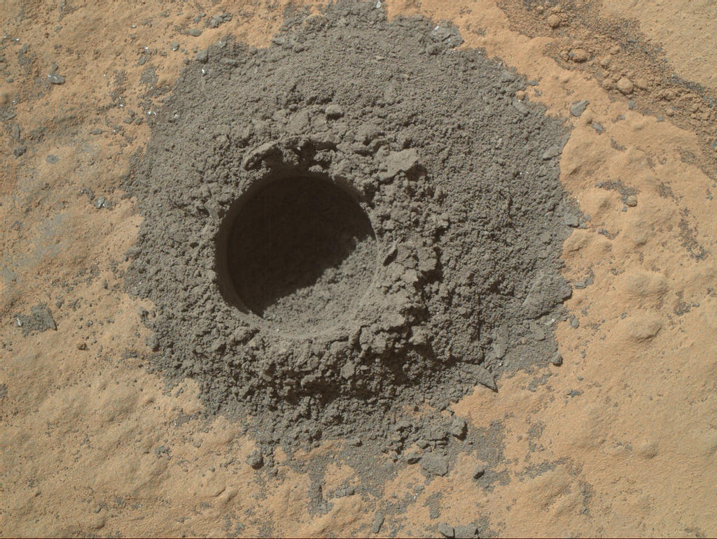
The drilling / sampling operation took place on Sol 621 (Monday May 5th, PDT, 2014), with the percussion drill mounted on the rover’s robot arm turret cutting a hole some 6.5 centimetres (2.6 inches) deep and 1.6 cem (0.63 in) across into a flat sandstone slab which had been dubbed “Windjana” shortly after Curiosity arrived in “The Kimberley” at the end of March 2014. The tailings gathered as a part of the drilling operations were delivered to the CHIMRA (Collection and Handling for In-Situ Martian Rock Analysis) system, in preparation for them to be transferred to the rover’s on-board science laboratory. Confirmation that the sample-gathering had been successful came early in the morning (PDT) on Tuesday May 6th.
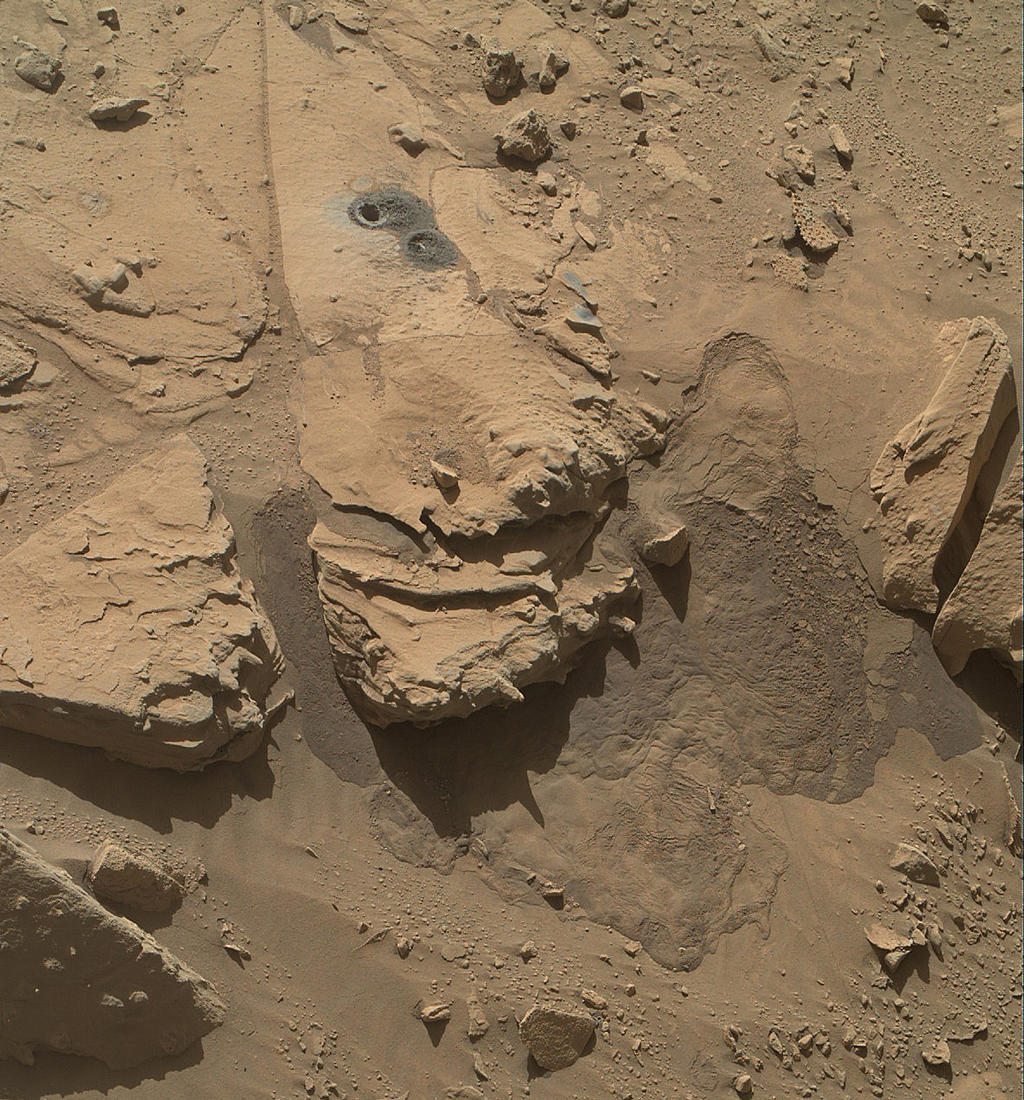
Holey moley. An image captured by the Mars Hand Lens Imager (MAHLI) Curiosity’s robot arm turret on Sol 627 (May 12th PDT, 2014) showing the sample gathering hole cut into “Windjana”. Dark tailings from the operation lay around the hole and have partially filled the test drilling hole just below it. The two patches of grey visible slightly to the right and blow the drill holes mark the points where Curiosity’s ChemCam laser was used to vapourise dust covering the surface of the rock. Surface material around the rock was subjected to miniature “landslides” as a result of the percussive hammering of the drill (click to enlarge)
The drilling operation, the third time Curiosity has gathered samples from inside a Martian rock for analysis, has caused some excitement among the mission team. “The drill tailings from this rock are darker-toned and less red than we saw at the two previous drill sites,” Jim Bell, deputy principal investigator for Curiosity’s Mast Camera (Mastcam) said after the drilling operation. “This suggests that the detailed chemical and mineral analysis that will be coming from Curiosity’s other instruments could reveal different materials than we’ve seen before. We can’t wait to find out!”
Curiosity’s first two drilling operations took place over a year ago in the “Yellowknife Bay” area of Gale Crater, some four kilometres (2.5 miles) north-east of “The Kimberley”. Analysis of those samples, gathered from mudstone yielded evidence that “Yellowknife Bay” had once been a part of an ancient lakebed environment which contained key chemical elements and a chemical energy source that long ago provided conditions favourable for microbial life.
Following their transfer to CHIMRA, the tailings cut from “Windjana” were sifted and graded in readiness for delivery to the ChemMin (Chemical and Mineralogical analysis) and SAM (Sample Analysis at Mars) suites of instruments, located in the body of the rover. The initial sample transfer to both instrument suites was made on May 15th PDT, 2014. and analysis of the samples should be carried out as the rover continues its journey towards the lower slopes of “Mount Sharp”.
A composite of eight shots from MAHLI showing successive dot-like strikes from the ChemCam laser, both within the sample drilling hole at “Windjana” and where the tailings have mixed with surface dust (top right). Such strikes allow the chemical composition of the dust and rock to be analysed (click to enlarge)
Prior to departing “The Kimberley”, Curiosity carried out a final set of science operations. These involved using the turret-mounted MAHLI (Mars Hand Lens Imager) and spectrometer to examine the texture and composition of the cuttings from the sample drill hole in situ. The ChemCam laser was also used to vapourise some of the drill tailings on the surface of “Windjana” and rock from the inside of the sample hole itself, allowing the ChemCam to analyse the chemical composition of the resultant vapours.
Thursday May 28th saw SpaceX, the private sector space company founded by Elon Musk, unveil the next iteration of their Dragon space vehicle, the Dragon V2.
Dragon has been in operation in an unmanned mode since 2010, and was the first commercially built and operated spacecraft to be recovered successfully from orbit. In May 2012, it commenced uncrewed resupply flights to the International Space Station (which I covered here) as a part of NASA’s Commercial Orbital Transportation Services (COTS) development programme.
Elon Musk unveils the Dragon V2 capsule, May 29th, 2014 (image: SpaceX)
Dragon V2 (which had previously been called Dragon Rider by the company) is a natural progression of the Dragon spacecraft, and while always in Spacex’s plans, having been originally announced in 2006, it has been part-funded by two US Government contracts, the Commercial Crew Development 2 (CCDev 2) in April 2011, and the Commercial Crew integrated Capability (CCiCap) in August 2012, both of which are focused on developing crewed vehicles capable of supporting the International Space Station (ISS) and of operating in low Earth orbit (LEO).
Dragon V2 is capable of carrying up to seven crew, or a combination of crew and cargo. The vehicle is intended to be reusable, and capable of landing almost anywhere in the world using propulsive-landing via its eight SuperDraco engines (Dragon 1 is only capable of making splash downs). However, Dragon V2 will retain a parachute descent system for use as a back-up, although it can still make a safe touch-down even if two of its eight descent engines fail. Also, unlike Dragon 1, which makes a close rendezvous with the ISS before being grabbed by one of the station’s robot arms and manoeuvred into a docking position, Dragon 2 will be able to undertake fully automated dockings with the ISS.
Dragon 2 making a control landing, post-mission (image: SpaceX)
Nor does it end there. There are some ambitious plans for Dragon. The head shield, for example, is already capable of protecting the vehicle during re-entry into the Earth’s atmosphere at velocities equivalent to those of a vehicle returning from the Moon or from Mars – and SpaceX has been working with NASA Ames Centre, California, on a conceptual uncrewed Mars mission evolution called Red Dragon.
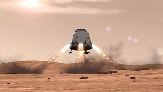
Artist’s visualisation of how Red Dragon might appear when landing on Mars were the project to go ahead (image: SpaceX)
Potentially funded under NASA’s Discovery mission programme, Red Dragon, if given the green light, would provide a cost-effective means for NASA to undertake a sample return mission to Mars, allowing up to two tonnes of samples to be returned to Earth for detailed investigation and analysis in 2022, ahead of NASA’s goal of sending humans to Mars in the 2030s.
Other have even more ambitious plans for Dragon and Mars. Dutch-based Mars One plans to kick-start a permanent, self-sufficient human colony on Mars from the mid-2020, with crews leaving Earth on a one-way trip every two years. According to the Mars One website, they hope to be able to use the Dragon vehicle and its associated Falcon 9 heavy launch vehicle also constructed by SpaceX, although there has been no public confirmation as to whether formal discussions with SpaceX have taken place.
Such plans aside, however, the first actual crewed mission for Dragon V2 is unlikely to occur prior to 2016. The next major milestone for the vehicle is a launchpad abort test, scheduled for later in 2014.
This will see the vehicle positioned at pad height and then launched to simulate an emergency in which the crew must escape their launch vehicle. After this, in 2015, there should be a high altitude abort test at Max Q, the period in the vehicle’s ascent when it is exposed to the maximum dynamic pressure. Both tests will feature the use of the vehicle’s SuperDraco engines, which form a part of the escape system as well as powering the craft during descent and landing. Capable of multiple re-starts and what is called “deep throttling”, the engines are themselves unique – the first ever fully printed rocket engines ever flown, produced by a direct metal laser sintering process.
If both of these tests are successful then it is conceivable that Dragon V2 could make an initial uncrewed orbital flight towards the end of 2015, and its first crewed flight in 2016.
Things are starting to pick-up on Mars once more as Curiosity starts into a new round of science studies in the region dubbed “The Kimberley”. Having been surveying the region since its arrival there at the beginning of April, the rover was commanded to move to a sandstone slab scientists dubbed “Windjana” after a gorge in Western Australia, and is in keeping with giving notable landmarks in the area unofficial names lifted from that part of Australia.
The slab lay a short distance roughly southwards from the rover’s position where the Mars Reconnaissance Orbiter (MRO) imaged it on April 11th, 2014. Following the initial selection of the slab as an area for further study, the rover was commanded to drive closer to it to enable further visual inspection. The slab is around 60 centimetres (2 feet) across, and was selected because it offered a good surface for drilling, and lay within what scientists call the “middle unit” because its location is intermediate between rocks that form buttes in the area and lower-lying rocks that show a pattern of striations.
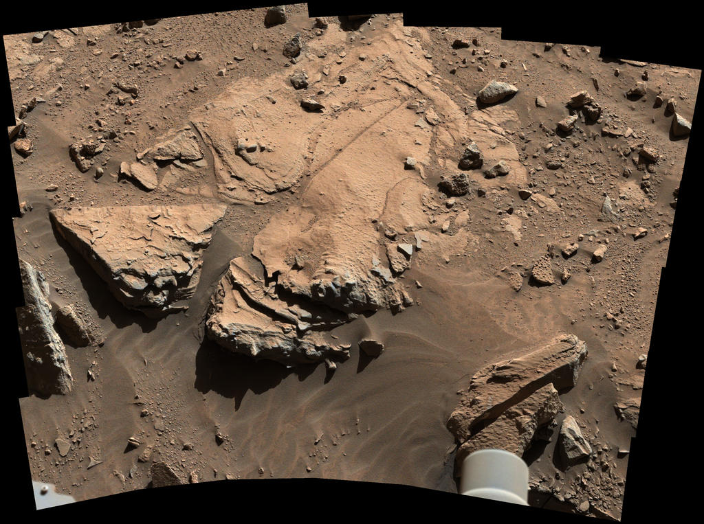
A white-balanced image, calibrated, linearly scaled and brightened to present colours that resemble those that would be seen under daytime lighting conditions on Earth, of the rock dubbed “Windjana”. The image combines several exposures taken by the Mastcam’s left-eye camera during the 609th Martian day, or Sol, of the rover’s work on Mars (April 23rd PDT, 2014).
The sandstone rock in the area is of particular interest to mission scientists because it represents a somewhat different environment to that studied extensively by Curiosity during the time it spent in the “Yellowknife Bay” area, drilling and sampling mudstone rocks.
“We want to learn more about the wet process that turned sand deposits into sandstone here,” Curiosity’s lead Project Scientist, John Grotzinger, explained. “What was the composition of the fluids that bound the grains together? That aqueous chemistry is part of the habitability story we’re investigating.”
Understanding why some sandstones in the area are harder than others also could help explain major shapes of the landscape where Curiosity is working inside Gale Crater. Erosion-resistant sandstone forms a capping layer of mesas and buttes. It could even hold hints about why Gale Crater has a large layered mountain, dubbed “Mount Sharp” (officially called Aeolis Mons), at its centre.
Once the rover had positioned itself close to the rock, initial inspection operations were carried out, which included using the turret-mounted spectrometer on Curiosity’s robot arm as well as the mast-mounted ChemCham laser so that the rock could be properly analysed ahead of any drilling operation. These operations also included deploying the rover’s “wire brush” to clean an area of the rock’s surface, removing dust and debris to expose the rock itself, allowing for further examination and analysis.
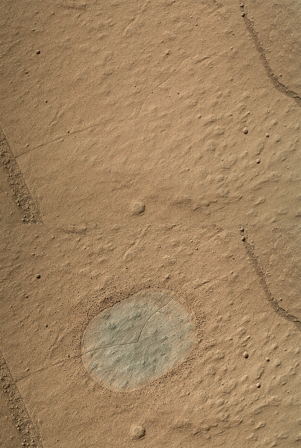
Clean sweep: a “before and after” animation showing a patch of the sandstone rock dubbed “Windjana” scrubbed clean of surface deposits ready for further examination. The images used in the animation were taken by the turret-mounted Mars Hand Lens Imager (MAHLI) during the 612th Martian day, or Sol (April 26th PDT, 2014). The exposed area of grey rock measures some 6 centimetre (2.5 inches) across.
Before any sample drilling could occur, however, the rover would need to carry out a “mini-drilling” operation, much as it did at “Yellowknife Bay”. Such operations both confirm the drill’s readiness for sample gathering and confirm that the subject rock is a suitable target for drilling and gathering sample material.
This “mini-drilling” operation took place on Tuesday, April 29th, cutting a hole around 2 centimetres (0.8 inch) deep into the rock. This allowed the science team to evaluate the interaction between the drill and this particular rock – an important factor given issues enountered due to vibration during the rover’s previous operations – and also for the tailings of powder rock created by the drilling operation to be examined for their suitability for collection by the drilling mechanism.
When collecting sample material, the rover’s hammering drill bores as deep as 6.4 centimetres (2.5 inches) into a target rock. As it does so, some of the tailings from the drilling operation are forced up into the drill bit itself, and delivered to one of two holding chambers (Chambers A and B in the diagram below) located in the head of the drill bit mechanism.
How the drill works: On the left, a view of the drill mechanism mounted on the rover’s turret, with the drill bit centre bottom. On the right a cutaway showing the sample collection mechanism in the drill bit
Once drilling is complete, the gathered samples are transferred to CHIMRA – the Collection and Handling for In-Situ Martian Rock Analysis system, also within the rover’s turret system, where the tailings are sifted and sorted ready for eventual transfer to the Curiosity’s on-board chemical laboratory systems, comprising the Chemical and Mineralogy (CheMin) and Sample Analysis at Mars (SAM) suites of instruments.
At the present time, the outcome of the analysis of the mini-drilling operation, and the suitable of “Windjana” as a sample-gathering point is unclear; however, it would appear likely that sample drilling operations will go ahead nearby as a result of this test.
An image from Curiosity’s Mars Hand Lens Imager (MAHLI) instrument shows the “mini-drilling” operation hole cut by the rover’s drill mechanism on Sol 615 (April 29th PDT, 2014). The hole is some 2 centimetres deep and 1.6 centimetres in diameter.
First Asteroid Image from the Surface of Mars
Curiosity racked-up another first on Sol 606 (April 20th), when the Mastcam captured the first image of asteroids taken from the surface of Mars. The image was combined with pictures captured the same night of the Martian Moons Phobos and Deimos, and the planets Jupiter and Saturn. Deimos, the outermost on the Martian moons, and which may have itself been an asteroid prior to wandering in Mars’ gravitational influence, appears at its correct location in the sky at the time the image of Ceres and Vista was captured. Phobos, Jupiter and Saturn, which were all imaged at different times, are shown as inset images on the left. All of the images form a part of ongoing astronomical work the rover has been performing periodically.
Ceres, with a diameter of about 950 kilometres (550 miles), is the largest object in the asteroid belt, large enough to be classified as a dwarf planet. Vesta is the third-largest object in the asteroid belt, about 563 kilometres (350 miles) wide. These two bodies are the destinations of NASA’s Dawn mission, which orbited Vesta in 2011 and 2012 and which is now on its way to begin orbiting Ceres in 2015.
A composite of images taken after nightfall on the 606th Sol (April 20, 2014, PDT) of Curiosity’s work on Mars, showing the asteroids Vesta and Ceres, and Mars’ outer moon, Deimos. The same night, the rover also captured images of Mars’ inner moon, Phobos, and the planets Jupiter and Saturn, shown in the inset images
The main image appears grainy, with Ceres, Vista and three stars appearing as streaks because it was captured over a 1-2 second exposure period. The graining on the image is the result of cosmic rays striking the camera detector is the image was captured. The images of Deimos, Phobos, Jupiter and Saturn were all captured over a much shorter 0.25-second exposure, thus rendering them as bright objects against a “clean” black background. Sunlight reflected by Deimos makes it appear overly large.
The interesting point (for those into astronomy) with the main image is that Vesta and Ceres would be naked-eye visible to anyone with average eyesight were they to be standing on the surface of Mars.
On Wednesday April 16th, NASA JPL released a remarkable image captured using the High Resolution Imaging Science Experiment (HiRISE) camera on the Mars Reconnaissance Orbiter (MRO).
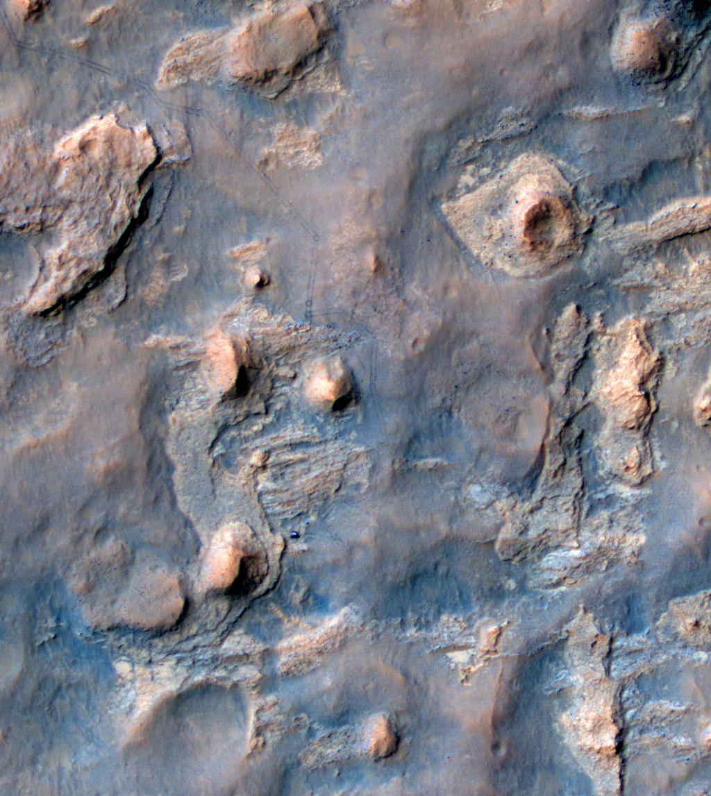
The image reveals the the Mars Science Laboratory, Curiosity parked alongside the multi-layered rock formation dubbed “The Kimberley”, as it prepares to undertake a range of science studies in the area.
The image was captured by MRO on April 11th during an overflight of the rover’s position as it sits at the foot of a rocky butte mission scientists have dubbed “Mount Remarkable”, and which forms a part of a multi-layered rocky location which has been dubbed “the Kimberley” due to its resemblance to a similar confluence of rock types found in Western Australia.
A rover’s progress: Curiosity, the blue form just off-centre in this false-colour image, sits at the foot of “Mount Remarkable”, a butte located in the area mission scientists have dubbed “the Kimberley”. the rover’s tracks can be seen leading back toward the top left corner of the image, where it entered the region on March 12th, 2014.
“The Kimberley” is an area of four distinguishable rock types exposed close together in a decipherable geological relationship to each other. As such, they should provide further clues about ancient environments that may have been favourable for life. It is of particular interest to Scientists because like “Yellowknife Bay”, where the rover spent several months analysing and drilling rocks, “the Kimberley” demonstrates features which suggest that some of the rocks have only been exposed for a short time, geologically speaking.
This matters because Mars doesn’t have a magnetosphere and thick atmosphere like Earth’s, which protect us from energetic particles from space that break down organic material. So, rocks that have been exposed or close to the surface for a very long time are less likely to contain complex organic material, which might either be the remnants of past life, or help inform scientists about past habitability, the potential to support life in an area – as was the case with “Yellowknife Bay”.
 Monday June 23rd was notable in two worlds as a special occasion.