Space Monday: beautiful Pluto, icy Enceladus, and jetting into space

new-horizon
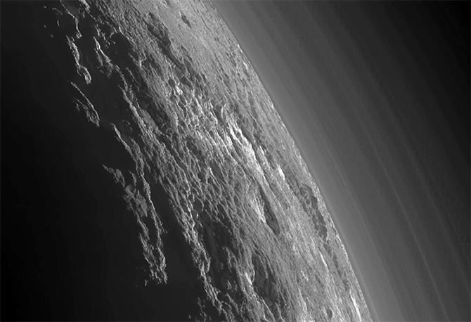
In September I reported on images captured by the New Horizons space probe of the night side of Pluto, backlit by the distant Sun. In a follow-up to those images, the New Horizons team has released stunning high-resolution images captured by the probe shortly after passing the point of closest approach to Pluto on July 14th, 2015.

The images were captured from a distance of just 18,000 km (11,000 miles) from Pluto using the Multi-spectral Visible Imaging Camera (MVIC), part of New Horizon’s Ralph suite of instruments, which were pieced together to form a magnificent view of Pluto with a resolution of some 700 metres per pixel.

The mosaic of images shows the rich complexity of both Pluto’s surface features and its atmosphere, the enhanced images clearly bringing the bands of haze in the latter into sharp relief.

An enhanced image of Pluto's night side, composed of images captured by the MVIC instrument on New Horizons on July 14th, 2015. As Pluto is "tipped over" on its axis by 120 degrees, the planet's north pole is to the right and south pole to the left
An enhanced image of Pluto’s night side, composed of images captured by the MVIC instrument on New Horizons on July 14th, 2015. As Pluto is “tipped over” on its axis by 120 degrees, the planet’s north pole is to the right and south pole to the left (image: NASA/JPL / JHUAPL / SwRI)

The clearest detail of Pluto’s surface can be seen to the right, which because the planet’s axis is tilted by 120-degrees, is the north polar region. The sheer ruggedness of the terrain can be seen here, some of the pitted hills almost looking like clouds above a distant landscape. However, the left side, and the south pole isn’t entirely without interest: caught by the glow of sunlight refracted by Pluto’s tenuous atmosphere, the rugged nature of the little world’s chaotic surface can also be seen.

Subject to enhancement, a portion of the images capturing the northern regions of Pluto  reveal even more detail, particularly within the complex layering of Pluto’s atmosphere, where the enhancements reveal it to be made up of around a dozen layers, far more than had been thought during New Horizon’s final approach to Pluto in late June. These layers are made up of tholins, soot-like organic compounds created as a result of ultraviolet radiation from the sun interacting with the upper layers of Pluto’s atmosphere. These particles, undergoing some chemical changes as they drift back down through the various layers, eventually precipitate down onto Pluto’s surface, staining it red.

An enhanced image of Pluto north polar region revealing an incredibly complex surface of hills and valleys, ice features and high mountains, while above can be seen an enhanced view of the complex atmospheric banding
An enhanced image of Pluto north polar region revealing an incredibly complex surface of hills and valleys, ice features and high mountains, while above can be seen an enhanced view of the complex atmospheric banding (image: NASA/JPL / JHUAPL / SwRI)

Cassini’s Enceladus Encounter

Cassini, NASA’s deep space probe exploring Saturn and his retinue of moons as a part of the Cassini-Huygens mission, is approaching the end of its 20-year mission. Launched in 1997, and following a 7-years transit to Saturn, Cassini has been studying the system in great detail, and delivered a tiny European lander vehicle, Huygens, to the surface of Titan, the largest moon in the solar system, and one with its own rich atmosphere, and standing bodies of liquid on its surface.

With fuel reserves set to expire in late 2017, Cassini will be ordered to fly into Saturn’s own dense atmosphere before it does so, where it will burn-up. In the meantime, however, the vehicle continues to return a marvellous wealth of data about the Saturn system, including several studies of another of the giant planet’s remarkable moons, Enceladus.

Enceladus revealed: captured on October 28th, this image reveals the icy beauty of encedaus as Cassini closes for its penultimate, and closest, approach to this tiny Moon with its hidden ocean
Enceladus revealed: captured on October 28th, this image reveals the icy beauty of the moon as Cassini closes for its penultimate, and closest, approach (image: NASA/JPL / Space Science Institute)

Like Jupiter’s moon Europa, Enceladus is a domain of ice, under which likely sits an ocean of liquid water. Shortly after arriving in orbit around Saturn, Cassini made the first of numerous flybys of the little Moon, which is just 500 km (310 mi) across, and detected the presence of a very thin atmosphere primarily made up of water vapour. In particular, the craft observed geysers erupting from the south pole, spewing water vapour, ice particles and other material into space, some of which likely contributes to Saturn’s “E” ring.

At the end of October 2015, Cassini made its penultimate flyby of Enceladus, passing over the Moon at an altitude of just 48 km (30 mi) and at a speed of some 30,000 kph (19,000 mph), diving through another of the geyser plumes in the process to measure the composition of gas and ice particles launched from the underground ocean.

A stunning images taken by Cassini following the October flyby reveals a crescent Enceladus floating above Saturn's magnificent rings
A stunning images taken by Cassini following the October flyby reveals a crescent Enceladus floating above Saturn’s magnificent rings (image: NASA/JPL / Space Science Institute)

In particular, the Cassini science team will be analysing the data returned by Cassini following the flyby to see if the sensors found any evidence of molecular hydrogen in the plumes. Doing so would help verify suspected hydrothermal activity is taking place on the floor of Enceladus’ ice-shrouded ocean which could give rise to hot environments rich in mineral and chemical deposits suitable for the development of microbial life, just as deep-ocean thermal vents here on Earth provide life-sustaining environments.

Cassini will make one more return to Enceladus on December 19th, but will pass further from the little Moon as its orbit gradually swings it around Saturn for a further and final set of encounters with giant Titan, before finally moving inwards to pass between Saturn and its rings for the first time to study Saturn’s atmosphere in detail as the mission draws to a close in 2017.

Dawn Descends Over Ceres

On October 23rd, the NASA / ESA joint mission to explore two of the solar system’s three “protoplanets” located in the asteroid belt between the orbits of Mars and Jupiter, commenced manoeuvres to lower itself to is final orbit around Ceres.

The Dawn spacecraft, which arrived at Ceres in March 2015, after a 2.5 year transit flight from Vesta, its first destination, fired its ion engine to start reducing its orbit from 1,450 kilometres (915 miles) to just 380 km (235 mi), a manoeuvre which should see the vehicle spiral gently downwards to arrive in its new orbit in mid-December. At that time, Dawn will commence a final mapping and data-gathering mission, providing images with a resolution of 35 metres (120 ft) per pixel.

Occator crater and its brights spots images from directly overhead and a distance of 1,470 km (915 miles) by the Dawn space vehicle
Occator crater and its bright spots images from directly overhead and a distance of 1,450 km (915 miles) by the Dawn space vehicle (image: NASA / JPL / DLR)

It is hoped that this final science orbit will offer definitive data on precisely what is giving rise to a series of odd bright spots within the crater Occator on Ceres, and which appear to be related to what seems to be a small and very localised trace atmosphere within the crater. Current thinking is the bright markings are salt or ice water deposits which are being out-gassed from Ceres’ interior.

Britain’s Spaceplane Gets £80 million Investment

SABRE is the name of a radical “air-breathing” hybrid engine which has been in development by  a small British company called Reaction Engines Limited (REL) since the late 1990s. The aim is to reduce the amount of on-board oxidiser required in the rocket combustion process by allowing the engine to draw on the air around it during the initial ascent through the denser part of the Earth’s atmosphere, much like a regular jet engine uses the air around it. Only when the air becomes too thin to support combustion does the rocket engine switch over to its on-board supplies of liquid oxygen to burn with its liquid hydrogen fuel.

Ultimately, REL hope to use the SABRE engine in a single stage to orbit (SSTO) vehicle called Skylon, a fully reusable space launch vehicle, capable of operating from and to a conventional runway just like an aeroplane, and carrying up to tonnes into low Earth orbit.  However, the SABRE engine potentially has a wide range of applications, including a purely “air-breathing” variant (called Scimitar) which could be used to power aircraft within Earth’s atmosphere at speeds close to five times that of sound.

REL propose using the SABRE engine in their Skylon spaceplane capable of lifting up to 15 tonnes (cargo or 24 passengers) into orbit. however, the engine has many potential uses, hence the interest from BASE Systems and the UK government (image: REL)

On Monday, November 2nd, REL announced that BAE Systems Ltd is to invest some £20.6 million (US $31.8 million) in REL in return for a 20% stake in the company, while the UK government has awarded a further £60 million (US $92.8 million). Together with recent funding from the EU, REL has now raised some £95 million (US $146.6 million)  to further develop SABRE.

Skulls in the Sky

Halloween 2015 brought with it a creepy-looking visitor which looked down on Earth as many across the world took to marking All Hallows Eve on Saturday, October 31st.

The visitor in question was asteroid 2015 TB145, a lump of rock around 600 metres (1,968 feet) across. Tumbling through space, it passed by the Earth at a distance of roughly 480,000 km (300,000 miles) – slightly further from us than the orbit of the Moon,  at a speed of some 126,000 kph (78,293 mph).

Such Earth-passing asteroids are not rare, although this one was only identified on October 10th, 2015. It well be the last close passage to Earth by a very large asteroid until 2027, and its size offered scientists a unique opportunity to image it using radar.

Asteroid 2015 TB145 in an eerily skull-lik image captured by the Are
Asteroid 2015 TB145 in an eerily skull-like image captured by the Arecibo Observatory on Friday, October 30th, 2015.

On Friday, October 30th, the The Arecibo Observatory in Puerto Rico used radar mapping to capture an image of the asteroid in which it looks like a gigantic skull.  It was all an optical illusion of course, the combined result of the radio reflections from the asteroid giving rise to the grey shaded image and the effect of pareidolia, in which the human brain perceives shapes and patterns that aren’t really there; as the asteroid tumbled through space, the similarities to a human skull were quickly lost as the radar reflections changed.

Nevertheless, it was fittingly spooky for Halloween!

Discover Gale Crater

I’ve written extensively about NASA’s Curiosity rover and its explorations within Gale Crater on Mars since its arrival there in August 2012. Now NASA and the Los Angeles Times have combined to provide a virtual reality exploration of Gale Crater, which examines some of the principal features to be found there, traces the rover’s route from crater floor and up the flank of “Mount Sharp” and which allows visitors to fly over the crater or take a guided tour using simple keyboard controls.

Space Sunday: from the Sun to Charon, and the death of a planet

Astrophotographer Mia Stålnacke caught this aurora display over Kiruna, Sweden, in March 2015

The Sun is the only star we can directly observe in detail. As such, it has been the subject of study for a long time, significantly so since the birth of the space age. As such, you’d think we know pretty much all there is to know about it; but the fact is that the Sun still has many mysteries – and surprises – of its own awaiting understanding and discovery.

One of these mysteries has been strange particle emissions rich in helium-3. These don’t form part of the more familiar coronal mass ejections (CMEs), which can have an elevated impact on Earth magnetosphere giving rising to more energetic aurorae, or with collimated X-ray flares. The cause of these helium-3 rich outbursts has until now been hard to trace because in order to be detected by the Advanced Composition Explorer (ACE) craft which is designed to study such energetic particles, they have to originate very close to the Sun’s limb, making any associated events hard to observe.

A look at the Sun’s right limb on January 26, 2010. Within the marked red square, a large-scale blast wave travels through the Sun’s atmosphere. These images were obtained with the help of NASA’s STERO A probe and show the Sun’s atmosphere in extreme ultraviolet light.
A look at the Sun’s right limb on January 26, 2010. Within the marked red square, a large-scale blast wave travels through the Sun’s atmosphere. These images were obtained with the help of NASA’s STEREO A probe and show the Sun’s atmosphere in extreme ultraviolet light.

However, on October 13th, two teams of scientists working independently of one another, but using the same data and images gathered from NASA’s STEREO solar observation vehicle and the Earth-orbiting ACE platform, announced they had pin-pointed the cause of the outbursts. They are the result of huge explosions occurring in the Sun’s atmosphere, which in turn create gigantic atmospheric shock waves in the Sun’s atmosphere which can extend over half a billion kilometres (300,000 miles) and advance at speeds of 300 km (190 mi) per second. It is believed the sheer speed of the shock waves from these explosions is sufficient to accelerate  the helium-3 (itself produced as a part of the overall fusion process in the Sun’s core), into a stream of particles thrown off into space.

While it has been confirmed the initial explosions are not related to CMEs or sunspots or other known solar phenomena, the precise reason for the explosions themselves has yet to be determined.

Charon Revealed

Images and data returned by the New Horizons space vehicle at the start of October have provided more details about Pluto’s companion, Charon, revealing it to be an even more fascinating world than had been anticipated.

Charon as revealed in the highest resolution images yet returned of that tiny world by New Hotizons (image: NASA/JPL / JHUAPL / SwRI)
Charon as revealed in the highest resolution images yet returned of that tiny world by New Horizons (image: NASA/JPL / JHUAPL / SwRI)

The images, captured in black and white by the probe’s LORRI camera, have been combined with images and data gathered by the RALPH suite of instruments to present a beautiful full-colour image of almost all of one face of Charon, as seen by New Horizons as it swept through its closest approach to both Charon and Pluto on July 14th, 2015.

Some 1,214 kilometres (753 miles) in diameter, Charon is about half the size of Pluto, and was only discovered in 1978.  Quite how it formed has been the subject of much debate. Prior to New Horizons’ visit, the most popular theory was that Charon coalesced from the debris of a collision between Pluto and another Kuiper belt object. However, New Horizons has so far failed to return any images of Pluto that hint at such a collision, and the make-up of the two worlds is less similar than might be expected were one the offshoot of the other. So the theory gaining ground now is that both bodies were already formed when they fell into orbit around one another.

A comparison of the Moons of Pluto as images by New Horizons, and their relative size

The latest images of Charon reveal a striking world, every bit as varied as Pluto, and marked by a massive series of fractures across its midriff, suggesting a massive upheaval in Charon’s past which split open its crust. The southern hemisphere also has a more youthful appearance than the region north of the fracture, suggesting that widespread resurfacing took place following the event, and that cryovolcanism (ice volcanoes) may today be contributing to maintaining the relatively smooth appearance of Charon’s southern regions. So like Pluto, Charon may still be an active world.

Continue reading “Space Sunday: from the Sun to Charon, and the death of a planet”

Space Sunday: of water, Apollo and space spies

CuriosityThe Curiosity rover team have released a further study showing that ancient Mars was capable of storing water in lakes over an extended period of time, and that this water was a principal component in the creation of “Mount Sharp”, the mound at the centre of Gale Crater, currently being investigated by the NASA rover.

This forms the latest in a series of reports on the subject of water on Mars and in Gale Crater to be published by the Curiosity science team, and comes almost a year after I wrote about studies released by the team which detailed how “Mount Sharp” – more formally known as Aeolis Mons – was most likely formed by sediments laid down  by successive wet period in Mars’ ancient past.

“Observations from the rover suggest that a series of long-lived streams and lakes existed at some point between about 3.8 to 3.3 billion years ago, delivering sediment that slowly built up the lower layers of Mount Sharp,” said Ashwin Vasavada, Mars Science Laboratory project scientist, discussing the new report.

In December 2014, NASA issued a report on how
In December 2014, NASA issued a report on how “Mount Sharp” was likely formed. On the left, the repeated depositing of alluvial and wind-blown matter (light brown) around a series of central lakes which formed in Gale Crater, where material was deposited by water and more heavily compressed due the weight of successive lakes (dark brown). On the right, once the water had fully receded / vanished from the crater, wind action took hold, eroding the original alluvial / windblown deposits around the “dry” perimeter of the crater more rapidly than the densely compacted mudstone layers of the successive lake beds, thus forming “Mount Sharp”

However, until Curiosity actually started studying “Mount Sharp” in detail,  the accuracy of the earlier studies couldn’t be completely verified. The latest results from the rover indicate that these wetter scenarios were correct for the lower portions of Mount Sharp, and that the filling of at least the bottom layers of the mountain occurred over a period of less than 500 million years, mostly as a result of material deposited by ancient rivers and lakes.

The new report also comes on top of confirmation that the recurring slope lineae (RSL) features seen on Mars from orbit are most likely the result of outflows of water which are occurring today. together they are reshaping some of the thinking around water on Mars – and what might have happened to it.

“What we thought we knew about water on Mars is constantly being put to the test,” said Michael Meyer, lead scientist for NASA’s Mars Exploration Programme. “It’s clear that the Mars of billions of years ago more closely resembled Earth than it does today. Our challenge is to figure out how this more clement Mars was even possible, and what happened to that wetter Mars.”

Strata at the base of
Curiosity has found plenty of evidence for water on the floor of Gale Crater, which likely took the form of one or more lakes during the wetter parts of Mars’ history, before becoming rivers and streams later. Strata at the foot of “mount Sharp” (shown above) strongly suggested water played a significant part in forming the mound, and the evidence for this being the case has continued to be revealed as the rover climbs the lower slopes

Currently, images of the flanks of the mound returned by the rover and from orbit suggest water-transported sedimentary deposition may have extended at least 150 to 200 metres (500 to 650 feet) above the crater floor, and possibly as high as 800 metres (approx 1/2 a mile). This both indicates that there was at least one standing body of water in the crater and further confirms that “Mount Sharp” was a direct result of sediments deposited by this water. Or at least, the lower slopes were; there is currently little evidence for the sedimentary strata extending about the 800 metre mark, however. This has led to speculation that wind-blown deposits are responsible for the upper reaches of the mound.

Taken together, the recent findings concerning Mars and its water suggest that the planet’s history is far more complex than had been thought. “We have tended to think of Mars as being simple,” John Grotzinger, the former project scientist for the Curiosity mission said of the latest findings.

“We once thought of the Earth as being simple too,” he continued. “But the more you look into it, questions come up because you’re beginning to fathom the real complexity of what we see on Mars. This is a good time to go back to re-evaluate all our assumptions. Something is missing somewhere.”

Pluto’s Water

The blue haze of Pluto's atmosphere
The blue haze of Pluto’s atmosphere: released on October 8th, this true colour image taken after the New Horizons spacecraft had completed its closest approach to the dwarf planet shows Pluto’s night side ringed by the blue haze of its thin atmosphere, as illuminated by the distant Sun, far away on the other side of the little world

The latest images and data to be received on Earth from NASA’s New Horizons space vehicle reveal Pluto’s atmosphere to be a rich blue in colour, and confirm that water ice exists on theplanet.

“Who would have expected a blue sky in the Kuiper Belt? It’s gorgeous,” said Alan Stern, New Horizons principal investigator as the striking image shown above was released as part of the latest batch of pictures and data to be received from the space craft and undergo processing and initial analysis.

The blue colour indicates that the haze within Pluto’s atmosphere is made up of a lot very fine of particulate matter, which scatters blue light from the Sun more easily than other colours, due to blue having a shorter wavelength (which is also the reason the sky we see here on Earth also appears blue, because that wavelength is easily scattered by the tiny particles making up our atmosphere).

In Pluto’s case, it’s thought that the particles in the atmosphere are largely tholins, created by ultraviolet radiation from the Sun breaking down the methane and nitrogen in Pluto’s upper atmosphere, allowing their molecules to gradually recombine into the more complex tholins, which draft down through the atmosphere, undergoing further changes, before eventually reaching the surface of the planet, giving it a distinctive reddish colour.

Instruments forming the Ralph suite aboard New Horizons have identified regions of exposed water ice on Pluto which occur in regions which have corresponding deposits of tholins. Quite what the relationship is between the two is unclear. The water ice deposits are shown in blue on the inset image simply for convience, and not because that's how they appear on Pluto
Instruments forming the Ralph suite aboard New Horizons have identified regions of exposed water ice on Pluto which occur in regions which have corresponding deposits of tholins. Quite what the relationship is between the two is unclear. The water ice deposits are shown in blue on the inset image simply for convenience, and not because that’s how they appear on Pluto

The discovery of water ice on Pluto has taken scientists by surprise. Not so much because it is there, but because it appears to be somehow related to areas of heavy tholin deposits. Confirmation of the presence of water ice came from data returned by the Ralph instrument suite aboard New Horizons, but just how widespread it might be isn’t clear, as it seems that it might be masked elsewhere by other surface material.

Continue reading “Space Sunday: of water, Apollo and space spies”

Space Sunday: of Martian water, avalanches and postcards

A false-colour image of Hale Crater on Mars showing recurring slope lineae (RSL) flowing downhill, which are inferred to have been caused by contemporary flowing water, hydrated salts detected within the dark-colours RSLs tending to confirm they hypothesis they were created by free-flowing water.
A false-colour image of Hale Crater on Mars showing recurring slope lineae (RSL) features flowing downhill. Hydrated salts detected within the dark-coloured RSLs tend to confirm the hypothesis they were, and are, created by free-flowing water.

On Monday, September 28th, NASA held a special press conference which, they had promised, would “solve” a “major” mystery about Mars.

As I noted in my Space Sunday update prior to the conference, the major speculation was that the US space agency would be discussing what are called recurring slope lineae (RSL) features on Mars.

RSLs have been the subject of intense debate and discussion since 2011, when an undergraduate called Lujendra Ojha published the first in a series of papers on their presence on Mars.  In essence, they are ridges and rills which appear on the slopes of hills and craters, notably in the equatorial regions of Mars. The significance here being that on Earth, identical features are always the result of free-flowing water.

Given that it is known that Mars once supported liquid water on its surface, the presence of these features wouldn’t be that exceptional were they part of the ancient landscape. However, as the “recurring” in the title suggests, the Martian RSLs appear to be active – recurring frequently, sometimes on the seasonal basis. renewing and growing, with new ones also being periodically created.

Two images studied by Ojha showing the flank of the same crater and showing what appear to be active RSLs.
Two images studied by Ojha showing the flank of the same crater. On the left, from 2007, a number of older RSLs, faded due to dust deposits, appear with a relatively new, dark RSL. By 2012 (on the right), that RSL feature has also faded, but a further new one has appeared

Given the overall similarities between RSLs seen on Mars and those seen on Earth, particularly in Antarctica, the common belief has been that liquid water is responsible for the features on Mars. If true, then it would indicate two things.

The first would be that Mars would appear to have a subsurface water table of some description – which would be consistent with the idea that as the planet lost its atmosphere, whatever water remained on the surface may have retreated underground. The second is that it would seem to indicate that Mars is still in some way geologically active, with some mechanism at work forcing this water to the surface and creating these sudden, if short-lived outflows.

The NASA conference coincided with the publication of another paper in Nature Geoscience by Ojha and his colleagues. both pointed directly to water being the cause of the Martian RSLs. In particular, they both report that spectral analysis of some of the more recent and broader RSL channels shows they are rich in hydrated salts, which strongly indicates the presence of water. These salts are consistent with the chemical signatures of magnesium perchlorate, magnesium chlorate and sodium perchlorate.

This is significant because the presence of perchlorate deposits in water can work to prevent that water freezing solid in the kind of summer daytime temperatures – around -23C (-10F) – often experienced in the regions where these RSLs are found. Thus, if held in suspension, they would create a watery brine capable for fluid motion, and which, if released in significant enough amounts, could give rise to the RSLs prior to the water itself sublimating rapidly into the tenuous Martian atmosphere, leaving the hydrated deposits behind.

Nepalese born
Nepalese born Lujendra Ojha is the student who started the investigations into RSLs and their possible relation to free-flowing liquid water on Mars (image: The Himalayan)

The conclusion is that it is indeed liquid water that is causing these RSLs on Mars, and that this water is in a liquid, rather than solid state, at least during certain periods, such that it can be forced to the surface.

However, all is still not entirely clear – something which tends to cast a shadow on the idea of a “mystery” having been “solved”. For one thing, if the RSL rills are below a certain width, they are entirely devoid of any hydrated deposits. This could mean that some other process is involved in their formation, which has yet to be determined. Further, the mechanism which is actually responsible for forcing the water to the surface a creating the outflow which result in these RSLs is still unknown.

Continue reading “Space Sunday: of Martian water, avalanches and postcards”

Space Sunday: of blood moons, Mars, Pluto and Ceres

A lunar eclipse "blood moon" seen Idaho, December 2011 (image: Matt Mills / Reuters)
A lunar eclipse “blood moon” seen Idaho, December 2011 (image: Matt Mills / Reuters)

The night of Sunday 27th / Monday 28th September  promises a very special astronomical event for those fortunate enough to have clear skies overhead and are willing to stay up late (in the UK and Europe). It will see a total lunar eclipse take place at the time when the Moon reaches perigee, its closest approach to Earth in its orbit and giving rise to both a so-called “supermoon” and a “Blood Moon”.

A “supermoon” occurs when a full moon coincides with the time when the Moon is nearing its minimum distance to Earth, a distance of roughly 363,000 kilometres (226,875 miles), leading to it appearing 7-8% larger than when seen as a full Moon at other points in its orbit. A “blood moon” is the result of the Earth’s atmosphere, lying between the Sun and Moon, scatter blue light more strongly than red, so the latter reaches the Moon more strongly, giving it a reddish-brown colour when seen from Earth.

A total lunar eclipse occurs when the Sun, Earth and Moon are lined up so that th Earth is between the Sun and Moon, and the later sits within the Earth's shadow
A total lunar eclipse occurs when the Sun, Earth and Moon are lined up so that the Earth is between the Sun and Moon, and the latter sits within the Earth’s shadow (image: NASA)

Lunar eclipses are not that rare – this one will be the second of 2015, for example. However, “supermoons” are somewhat rarer. The last was in 1982, and the next will not be until 2033. So, if you want to see a really big blood moon, and you live in Western Europe, West Africa, the Eastern side of the USA and Canada or south America, then the 27th / 28th September is the night to do so. People further afield – eastern Asia, the middle east, eastern Europe and the western sides of Canada, the USA and South America will see a partial eclipse.

In the UK, the period of eclipse will start at around 01:00 BST (00:00 GMT) on the morning of Monday, 28th September, and run through until around 05:00 BST (04:00 GMT). That’s from 20:00 through to around 01:00 EDT in the USA / Canada, and 02:00 through 06:00 CET in Europe).

A total lunar eclipse and the gradual change in the Moon’s colour as seen from Earth which sees total lunar eclipses sometimes referred to as “blood moons” – the result of sunlight passing through the Earth’s atmosphere and striking the Moon’s surface (animation: Wikipedia)

The eclipse brings to a close what is referred to as a “tetrad” of total lunar eclipses – that is, four occurring “back-to-back”, with no partial eclipses between them, the first of which occurred in April 2014 and the “middle two” in October 2014 and April 2015. Some have a misguided view that this “tetrad” as being of particular significance because such events are “rare”, and this particular one started on the Passover.

However, while there can be long periods of time between occurrences of tetrads, they can also pop-up relatively frequently. For example, this century will see a total of nine tetrads occur, the first having taken place in 2003/4. Nor is the fact that this particular series started on the Passover particularly unusual; there have been eight tetrads so far coinciding with Passover since the first century AD.

So, if you are in a position to see the eclipse, you can leave the tinfoil hat on the table and step outside quite safely. Totality should occur around two hours after the eclipse starts (e.g. 03:00 BST in the UK / 04:00 CET, 22:00 EDT on the 27th September), and that’s the best time to enjoy the blood moon in all its glory.

The eclipse will also give NASA the chance to measure the full range of temperature variations during  such an event. This will be done by the Lunar Reconnaissance Orbiter (LRO), a solar-power vehicle which has been observing the Moon since 2009.

Normally during an eclipse, the LRO has most of its systems powered down to reduce the load placed on the battery systems. However, mission controllers are confident they will be able to run an instrument which will allow it to accurately measure the amount of heat loss the surface of the Moon experiences when inside the Earth’s shadow, further helping them to understand the composition of the Moon’s regolith and its function as an insulator.

Continue reading “Space Sunday: of blood moons, Mars, Pluto and Ceres”

Space Sunday: see Pluto’s mountains and the size of the Solar System

Back lit by the sun: Pluto's hazy atmosphere seen from just 18,000km (11,000 miles) and 15 minutes are the point of closest approach to the planet by the New Horizons spacecraft on July 14th, 2015. To the upper right of the planet can be seen the icy expanse of "Sputnik Planum", bordered below and to the left by tall mountains, and to the right by what appears to be glacial outflows. Image courtesy of NASA / JHU / APL,
Backlit by the Sun: Pluto’s hazy atmosphere seen from just 18,000km (11,000 miles) and 15 minutes are the point of closest approach to the planet by the New Horizons spacecraft on July 14th, 2015. To the upper right of the planet can be seen the icy expanse of “Sputnik Planum”, bordered below and to the left by tall mountains, and to the right by what appears to be glacial inflows. Image: NASA / JHUAPL / SwRI (click for full size)

Just when you thought images of Pluto returned by the New Horizons spacecraft could get any more awe-inspiring, NASA / JHU  APL release a set of raw images that are utterly stunning.

The images come from the wide-angle Ralph/Multispectral Visual Imaging Camera (MVIC) on the space craft and were captured just 15 minutes after the vehicle reached is point of closest approach to the little world, and thus from a distance of just 18,000 km (11,000 miles) from Pluto.

The stunning vistas presented in the image show the ice plains of “Sputnik Planum” bordered to the left and from below by Pluto’s huge mountain ranges, informally named Hillary and Norgay, Montes after the first partnership to successful reach the summit of Mt. Everest here on Earth. All of this is dramatically backlit by sunlight reflected through Pluto’s hazy atmosphere to create a wonderful scene said to be reminiscent of views of the Antarctic viewed from space or very high altitude.

A closer view: In this image just 380 km (230 miles) across, shows "Sputnik Planum" bordered to the west by towering mountains reaching up to 3,500 metres (11,000 ft) in altitude. In the foreground sit the informally-named Norgay Montes, and on the skyline to the top and left of the image, the Hilary Montes
A closer view: in this image just 380 km (230 miles) across, shows “Sputnik Planum” bordered to the west by towering mountains reaching up to 3,500 metres (11,000 ft) in altitude. In the foreground sit the informally named Norgay Montes, and on the skyline to the top and left of the image, the Hillary Montes. Image: NASA / JHUAPL / SwRI (click for full size)

However, the images aren’t just notable for the panoramic beauty; they actually reveal a lot about what is happening in the Plutoian atmosphere. Because of the back lighting from the Sun, the high-resolution MVIC has revealed just how complex Pluto’s atmosphere is, comprising multiple layers of nitrogen and other gases rising to around 100 km (60 mi) above Pluto’s surface (and visible as a banding in the images above).

“In addition to being visually stunning, these low-lying hazes hint at the weather changing from day-to-day on Pluto, just like it does here on Earth,” said Will Grundy, lead of the New Horizons Composition team from Lowell Observatory, Flagstaff, Arizona.

What is also exciting the science team is evidence within the images for Pluto having a complex “hydrological” cycle which seems to be comparable in some ways to that found on Earth – only on Pluto, it involves nitrogen ice, rather than water ice.

When compared with images captured as New Horizons approached Pluto, the MVIC images further suggest that the regions eastward of “Sputnik Planum” appear to have been encroached over time by ices and material possibly evaporated from the surface of “Sputnik Planum” to be deposited on the higher lands as a new ice blanket, which in turn appears to have formed glacial formations flowing back into “Sputnik Planum”.

Glacial flow on Pluto: deposits of frozen nitrogen which have accumulated on the uplands on the right side of this 630 km (390 mi) wide image has formed glacial flows leading from the uplands beck into "Sputnik Planum" draining from Pluto’s mountains onto the icy plain through the valley system indicated by the red arrows (the valleys average between 3 and 8 km (2 and 5 mi) in width). In the meantime, the ice of the plain appears to be flowing outwards and towards the uplands, as indicated by the blue arrows. Image: NASA/JHUAPL/SwRI.
Glacial flow on Pluto: deposits of frozen nitrogen which have accumulated on the uplands on the right side of this 630 km (390 mi) wide image has formed glacial flows leading from the uplands beck into “Sputnik Planum” draining from Pluto’s mountains onto the icy plain through the valley system indicated by the red arrows (the valleys average between 3 and 8 km (2 and 5 mi) in width). In the meantime, the ice of the plain appears to be flowing outwards and towards the uplands, as indicated by the blue arrows. Image: NASA / JHUAPL / SwRI (click for full size)

“We did not expect to find hints of a nitrogen-based glacial cycle on Pluto operating in the frigid conditions of the outer solar system,” said Alan Howard, a member of the mission’s Geology, Geophysics and Imaging team from the University of Virginia, Charlottesville. “Driven by dim sunlight, this would be directly comparable to the hydrological cycle that feeds ice caps on Earth, where water is evaporated from the oceans, falls as snow, and returns to the seas through glacial flow.”

To Scale: The Solar System

We’re all familiar with the idea that the solar system is so vast, that it is almost impossible to show the Sun and the major planets proportional to one another and at a scale where all the later are both visible and have orbits which can be adequately encompassed in an easily viewable space.

1972: The Blue Marble (click to enlarge)

Obviously, some models do exist; the Lowell Observatory in Arizona, USA, for example, has a walk that allows visitors to travel from the sun and by each of the planets, but it’s not always easy to clearly grasp the sheer scale of things. The same goes for digital models (and a few have been built within virtual worlds like Second Life).

With this issue of scale and proportion in mind, Wylie Overstreet and Alex Gorosh set out to produce a scale model of the solar system that might help people understand just how vast our planetary back yard is when looked at on a human scale.

They started with a blue marble to represent the Earth, echoing the famous photograph taken on December 7, 1972, by the crew of Apollo 17 en route to the Moon and which NASA dubbed the Blue Marble.

Continue reading “Space Sunday: see Pluto’s mountains and the size of the Solar System”