Of updates and wheel bashing

CuriosityNASA’s Curiosity rover Has completed a significant software upgrade, marking the third time the rover’s flight software has been updated since arriving on Mars in August 2012. The update was originally scheduled to take place over the course of a week in early November. However, during the course of the software upload, Curiosity unexpectedly committed a (non-threatening) software reboot (technically referred to as a “warm reset”), which eventually saw the software reverted to its original state.

Analysis of data received as a result of the reset revealed a catalogue file for the existing onboard software was triggered as a result of the newly uploaded flight software. As a result of this analysis the rover team were able to determine the steps required to ensure the correct software execution took place before allowing the rover to resume normal operations using the existing flight software (version 10).

A second attempt was then made up upload and execute the new flight software (version 11) over the course of a week earlier in December,   which saw the rover transition to the new software without incident.

The new software further expands the rover’s ability to deploy and use its robot arm and the turret-mounted science instruments and tools while the vehicle is operating on sloping surfaces – a vital requirement once Curiosity starts exploring the lower slopes of “Mount Sharp”. The software also further enhances the rover’s ability to safely store and retrieve navigational data, increasing its autonomous driving abilities even further.

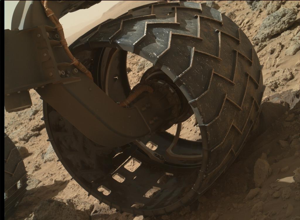
Over the last several weeks, Curiosity has been driving over exceptionally rugged terrain while en route to a point where it can traverse a series of sand dunes lying between it and “Mount Sharp” and start its explorations there. As a result of this, concerns have been raised that the rover’s six aluminium wheels are perhaps suffering an accelerated wear.

While the wheels can sustain a significant amount of damage without impairing the rover’s driving abilities, the mission team have decided to locate and drive the rover to a relative smooth area of Gale Crater where the robot are can be deployed to use the Mars Hand Lens Imager (MAHLI) to inspect each wheel for holes and other signs of damage.

“We want to take a full inventory of the condition of the wheels,” said Jim Erickson, project manager for the NASA Mars Science Laboratory Project. “Dents and holes were anticipated, but the amount of wear appears to have accelerated in the past month or so. We would like to understand the impact that this terrain type has on the wheels, to help with planning future drives.”

Depending upon the outcome of these checks, it may be that mission planners will opt to review the rover’s course to “Mount Sharp” and destinations along the way in order to try to reduce the amount of time spent traversing such rough terrain.

Curiosity’s left front wheel shows signs of accelerated wear as a result of travelling across terrain that is rough even by Martian standards. As a result of this, mission managers plan to have all six wheels checked-out for wear and tear in the near future. This image was taken by the Mars Hand Lens Imager (MAHLI) mounted on the rover’s robot arm turret on Sol 469 (November 30th, 2013). Note, also, the heavy coating of dust and dirt on the wheel’s drive arm. At the time this image was captured, Curiosity had driven 4.47 kilometres (2.78 miles).

Almost Four Miles

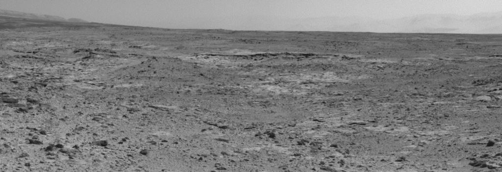
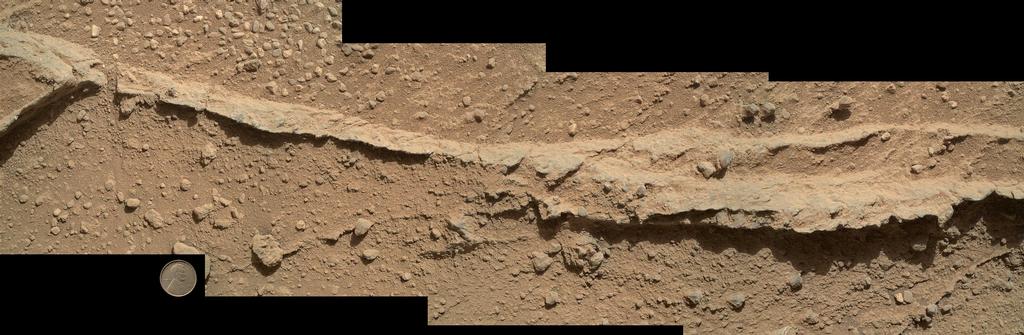
On December 8th, 2013 – Sol 477 of the mission, Curiosity clocked-up  a distance of 4.61 kilometres  (3.86 miles), and the rover paused to take a series of images of its location using the mast-mounted monochrome Navcams, which were then put together to form a cylindrical mosaic (below).

Click to enlarge

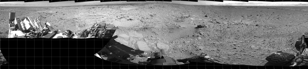
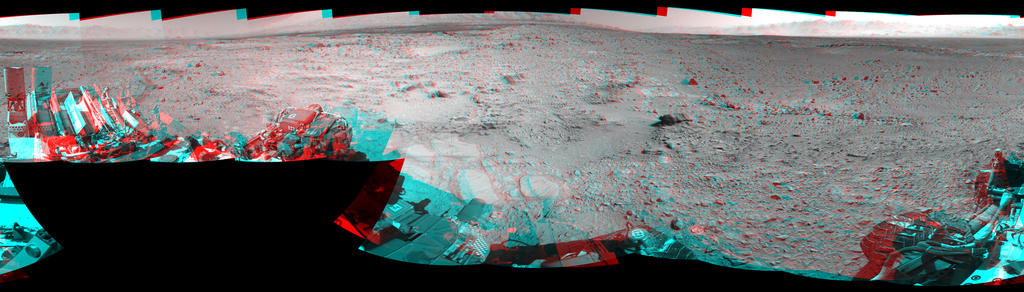
In the image, north is at either end of the mosaic, and south in the centre . The black squares are areas outside of the visual range of individual images used to create the mosaic. The images were individually captured by the left and right Navcam systems, and the two sets of images combined to offer a stereo view of Curiosity’s surroundings which can be seen using red-blue glasses with the red lens on the left (below).

Click to enlarge

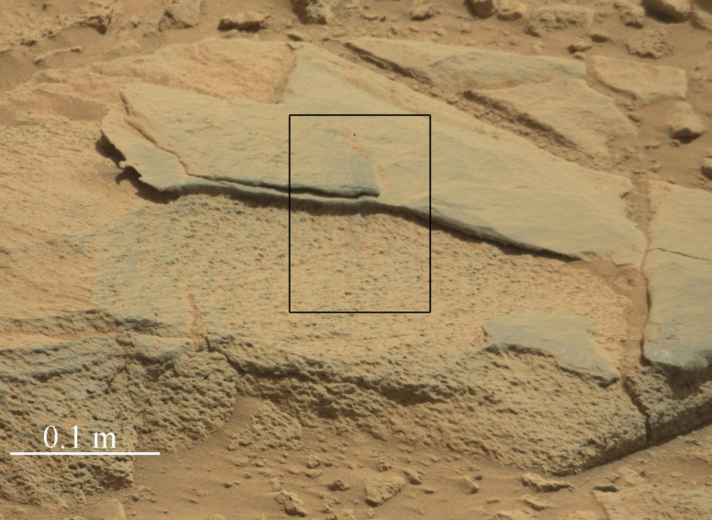
In my last MSL report, I referenced the research into the age of the rocks in Gale Crater and the effects of weathering and erosion. Understanding of both helps scientists learn about the processes at work close to the surface of Mars, infer whether features were predominantly formed by action of wind or water (or a combination of both, and where one took over from the other), and understand relative levels (in ages) different rock has been exposed to cosmic radiation. Further images used in that research have since been released.

Click to enlarge

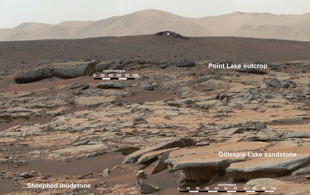
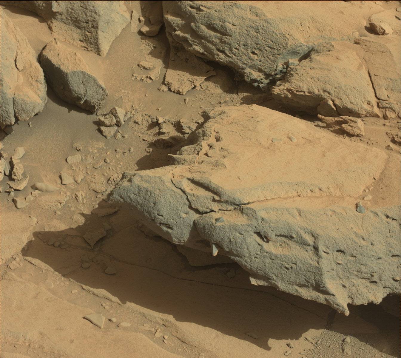
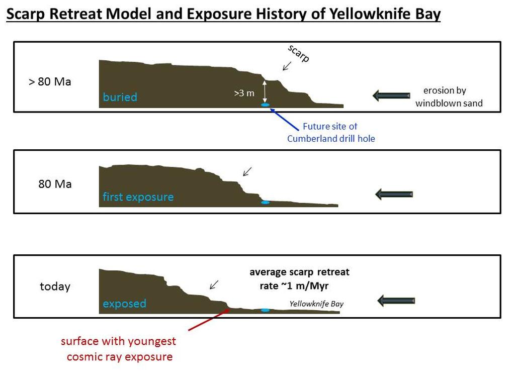
The image above show a mosaic put together using pictures captured by Curiosity’s Mastcam system on Sol 188 (February 14th, 2013), while the rover was operating in the “Yellowknife Bay” area. Looking west-northwest, the scene shows the various levels of rock which have been exposed in a process known as wind-driven scarp retreat, which can be described as the sideways erosion of a vertical face.

In the lower left corner is the “Sheepbed” mudstone deposit, which contains the “Cumberland” rock formation from which Curiosity gathered drilling samples. Gas analysis of the samples (some of which were saved by the rover and further analysed during the long road trip towards “Mount Sharp”) suggest the rock has only been exposed for about 80 million years – which is a lot more recent an exposure than previous estimates of the overall exposure of the Martian surface to the rigours of cosmic and solar radiation had suggested.

The evidence for wind erosion being the primary cause of exposure is strongly suggested to the right of the image, where erosion of the mudstone is clearly undercutting the “Gillespie Lake” sandstone layers.  These layers were about 15.4 metres (50 feet) from the rover. The mid-image “Point Lake” layers are some 36 metres (118 feet) from the rover, while the rocky outcrop marked by the white “X” is around 240 metres (780 feet) away, and on an elevation about 13 metres (43 feet) higher than “Sheepbed” and “Gillespie”.

A key aspect of understanding how and when such exposure of previously hidden rock layers occurred is that it gives the rover team better insight for selecting future targets for drilling to investigate whether organic chemicals have been preserved in rocks.

This set of drawings depicts cross sections of the “Yellowknife Bay” area of Mars’ Gale Crater at three points in time going back more than 80 million years (>80 Ma). Analysis of samples indicate the “Cumberland” rock target has been exposed at the surface for about 80 million years. Longer ago than that, the drill site was covered with about 10 feet (3 meters) of rock, as depicted in the top panel. At about 80 million years (middle panel), “Cumberland” was exposed as the scarp retreated due to abrasion by windblown sand. The sideways erosion, or retreat, occurred at an average rate of about one metre (3 feet) per million years (click to enlarge)

Related Links

  • MSL reports in this blog

All images courtesy NASA / JPL

.

100,000 zaps and a Sievert

CuriosityNASA’s Mars Science Laboratory (MSL) rover Curiosity chalked-up another milestone on October 30th, 2013, when the laser which comprises part of the Chemistry and Camera instrument (ChemCam)  system mounted at the top of the rover’s mast, was fired for the 100,000 time.

The shot was one of a series of 300 fired at a total of 10 locations on a rock called “Ithaca”, and was taken at a range of 4.04 metres (just over 13 feet) from  the target. The laser is used to vaporise tiny amounts of an object (the target area being around the size of a pin head), producing a spark of plasma (ionised gas). This spark is observed via a telescope which also forms a part of the ChemCam system, and the spectrum of light from the spark is analysed to identify chemicaal and mineral elements within it.

The rock “Ithaca” shown here, with a rougher lower texture and smoother texture on top, appears to be a piece of the local sedimentary bedrock protruding from the surrounding soil in Gale Crater. This image, taken by Curiosity’s Mast Camera (Mastcam), was captured on Sol 439 (October 30th, 2013). The rectangle indicates the area where ChemCam used its laser and remote micro-imager to inspect “Ithaca”. That inspection included the 100,000th laser shot fired by ChemCam on Mars

Each pulse from the laser delivers more than a million watts of power for about five one-billionths of a second. The technique used by ChemCam, called laser-induced breakdown spectroscopy, has been used to assess composition of targets in other extreme environments, such as inside nuclear reactors and on the sea floor. Experimental applications have included also environmental monitoring and cancer detection. MSL is the first mission to use the technique on another planet.

minerals-dec-13
A graph showing a spectrum recorded by ChemCam which averages data from multiple laser firings at the same point on the rock “Ithaca” on Sol 439, and which included to 100,000th laser shot. The spectrum is typical of Martian volcanic (basalt) material. Although Ithaca is a sedimentary rock, the particles in the sediments that became the rock originated in igneous source rocks. The elements identified from the spectrum include a standard major-element suite of silicon, magnesium, aluminium, calcium, sodium, potassium, oxygen and titanium. Chromium and manganese, though not labelled, were also present (click to enlarge)

Virtually every shot taken by the laser yields a spectrum of data which is returned to Earth. Most targets get zapped at several points with 30 laser pulses at each point. An international team of scientists and students is mining information from ChemCam to document the diversity of materials on the surface of Gale Crater and the geological processes that formed them.  The range of materials recorded so far includes dust, wind-blown soil, water-lain sediments derived from the crater rim, veins of sulphates and igneous rocks that may be ejecta from other parts of Mars.

Since reaching the 100,000 total in late October, the laser has been fired a further 2,000 times. ChemCam also includes a micro-imager camera, which has taken over 1600 images during the time the rover has been operating on Mars.

The ChemCam mast element on Curiosity


Four Billion Years

In a little more than a year on the Red Planet, Curiosity has determined the age of a Martian rock, found evidence the planet could have sustained microbial life, taken the first readings of radiation on the surface, and shown how natural erosion could reveal the building blocks of life. MSL team members presented these results and more from Curiosity in six papers published on December 9th, 2013 by Science Express and presented them in press briefings and talks at the Fall Meeting of the American Geophysical Union in San Francisco.

As a  part of its operations, Curiosity has carried out a number of sample drillings into rocks on Mars. The second rock, dubbed “Cumberland” from which the rover obtained cuttings for analysis is now the first rock ever to be dated while sitting on another planet. Analysis of the mineral ingredients in the cuttings obtained from “Cumberland” estimates the age of the rock to be about 3.86 to 4.56 billion years; this matches estimates as to the overall age of Gale Crater itself, obtained through other means, which suggests that the techniques being used to analyse the samples gathered by the rover are reliable.

“The age is not surprising, but what is surprising is that this method worked using measurements performed on Mars,” Kenneth Farley, from the California Institute of Technology and a co-author of one of the new papers, said. “When you’re confirming a new methodology, you don’t want the first result to be something unexpected. Our understanding of the antiquity of the Martian surface seems to be right.”

Before they could measure rocks directly on Mars, scientists estimated their ages by counting and comparing the numbers of impact craters on various areas of the planet. The crater densities are correlated with ages based on comparisons with crater densities on the moon, which were tied to absolute dates after the Apollo lunar missions returned rocks to Earth.

The Cumberland sample analysis was a fundamental and unprecedented measurement which had been considered unlikely even as recently as the rover’s arrival on Mars in August 2012. To obtain it, Farley and his colleagues adapted a 60-year-old radiometric method for dating Earth rocks that measures the decay of an isotope of potassium as it slowly changes into argon, an inert gas. Argon escapes when a rock is melted. This dating method measures the amount of argon that accumulates when the rock hardens again.

The researchers also assessed how long Cumberland has been within about an arm’s reach of the Martian surface, where cosmic rays striking the atoms of the rock produce build-ups of gasses Curiosity can measure. The analysis of different gases present in the rock yielded exposure ages in the range of 60 million to 100 million years. This suggests shielding layers above the rock were stripped away relatively recently. Combined with clues of wind erosion Curiosity has observed, the exposure-age discovery points to a pattern of windblown sand eroding relatively thick layers of rock, which form a retreating vertical face, or scarp.

“The exposure rate is surprisingly fast,” Farley said. “The place where you’ll find the rocks with the youngest exposure age will be right next to the downwind scarps.”

Continue reading “100,000 zaps and a Sievert”

Of volts and launches and looking for answers in the air

CuriosityIt’s been an eventful week for Mars-related activities. After suffering a software reset on November 7th, as reported on in my last MSL update, the rover Curiosity experienced a second problem on November 17th.

This was caused by an unexpected voltage change being detected in the vehicle, described as a “soft” short, meaning that electricity is unexpectedly passing through something that is partially conductive, and in difference to a “hard” short, such as one electrical wire contacting another.

The short was first noted as a voltage difference between the chassis and the 32-volt power bus that distributes electricity to systems throughout the rover. Data indicating the change were received on Sunday November 17th, Curiosity’s 456th Martian day. Prior to the short occurring, the voltage level had been a consistent 11 volts; however, the data received indicated it has dropped to 4 volts.

While there was no immediate danger, as the rover’s electrical system is designed with the flexibility to work properly across a range of voltages – a design feature called “floating bus” – the decision was taken to suspend science operations while matters were investigated.

The Liberty 1909 penny mounted on Curiosity’s flank and used to calibrate the Mars Hand Lens Imager (MAHLI) mounted on the robot arm, as imaged on Sol 411 (October 2nd, 2013) at MAHLI’s highest resolution, some 14 micrometres per pixel. Note the dust and clumps of dust adhering to the coin despite it being vertically mounted on the rover

This was actually the second soft short Curiosity has experienced.  The first occurred on the very day it arrived on Mars – August 5th/6th 2012 – when the bus-to-chassis voltage dropped from about 16 volts to about 11 volts. This was thought to be related to explosive-release devices used for deployments shortly before and after the landing, but did it not and has not interfered with the rover’s operational capacity or capabilities.

Although the voltage change did not pose any immediate threat, and the vehicle did not enter a safe mode status, nor was it related to the earlier software reset, such soft shorts can reduce the robustness of the rover’s electrical systems for tolerating other shorts in the future. Further, they can indicate a possible problem in whichever component is the site of the short. Hence the decision to suspend science operations and take time to check some of the possible root causes for the voltage change.

Subsequent analysis revealed that the voltage drop occurred intermittently three times in the hours before it became persistent. Some six days were spent in root cause analysis using data returned by the rover, which saw a number of potential causes suggested by mission engineers eliminated. This resulted in the most likely cause being identified as an internal short in Curiosity’s power source, the Multi-Mission Radioisotope Thermoelectric Generator (MMRTG or RTG for short).

Due to resiliency in the RTG design, this type of short does not affect operation of the power source or the rover. In fact, similar generators on other spacecraft, including NASA’s Cassini at Saturn, have experienced shorts with no loss of capability, and testing of an Earth-based RTG over many years found no loss of capability despite the presence of these types of internal shorts.

As a result of these findings, the rover was commanded to re-start science activities on November 23rd, and data returned from Curiosity’s onboard monitoring systems indicated that voltage levels had successfully returned to levels prior to that of the November 17th incident, a sign which is again indicative of an internal short within the RTG systems.

The resumption of science activities was marked by the rover delivering a further sample of rock cutting gathered some 6 months ago from an outcrop dubbed “Cumberland” in the “Yellowknife Bay” area of Gale Crater. A number of samples from the outcrop have already been analysed by the Sample Analysis at Mars (SAM) suite of instruments, which has the flexibility to be able to carry out such analyses a number of different ways, allowing significantly more data to be gathered on samples of the same rock gathered and stored by the rover.

Continue reading “Of volts and launches and looking for answers in the air”

Resets, safe modes, and the journey so far

CuriosityIt’s been fairly quiet as the Mars Science Laboratory (MSL) rover Curiosity continues driving towards the point at which it is hoped the rover can traverse between a line of low-lying sand dunes and start exploring the lower slopes of Aeolis Mons, which NASA has dubbed “Mount Sharp”.

However, Thursday November 7th saw an unexpected hiccup in proceedings as Curiosity unexpectedly performed a “warm reset” (software reboot).  This occurred around four and a half hours after the new flight software uploaded to the rover (see my last mission report) had been temporarily loaded into memory as a part of the uploading and commissioning of the software, and while the rover was also transmitting data to the Mars Reconnaissance Orbiter (MRO) for later transmission to Earth.

A warm reset is executed when the flight software identifies a problem with one of the operations it is executing which may adversely affect the rover’s operations, and is a standard fault protection mode on all automated craft operated by NASA. It resets the software to its initial state, preventing further issues occurring. While there have previously been problems with Curiosity’s on-board computers, this was actually the first time since the rover’s arrival on Mars 16 months ago that a fault-related software warm reset had been executed.

Curiosity, seen here in an artist's impression working on Mars, suffered its first software reset on November 7th
Curiosity, seen here in an artist’s impression working on Mars, suffered its first software reset on November 7th

Following the reset, the rover resumed communications, but the mission team initiated a root cause analysis for the reset using the ground testbed unit (essentially, Curiosity’s Earthside “twin”). This revealed an error in a catalogue file for the existing onboard software was triggered when the catalogue file was executed by the newly uploaded flight software, causing the reset.  As a result of this analysis, the flight software team were able to determine the steps required to recover the rover to its operating state prior to the reboot. These were successfully uploaded to Curiosity, and on Sunday November 10th, the rover set confirmation to mission controllers that it has successfully transitioned back to a nominal surface operations mode.

“We returned to normal engineering operations,” software and systems engineer Rajeev Joshi from the Curiosity team at JPL reported following the transition. “We are well into planning the next several days of surface operations and expect to resume our drive to Mount Sharp this week.”

Following the successful reinstatement of normal operations for the rover, the mission science team resumed planning for the next stage of Curiosity’s surface activities, which were due to restart on Thursday November 14th.

Continue reading “Resets, safe modes, and the journey so far”

A Martian invasion

CuriosityNo, this isn’t a return to coverage of Wars of the Worlds in  SL. November marks the start of the next round of missions to Mars, with two new orbiters about to depart Earth as a part of our efforts to better understand the Red Planet and its atmosphere. Meanwhile, and despite a lack of headline news, NASA’s Mars Science Laboratory (MSL) continues its own explorations of the Red Planet, as does its little cousin Opportunity, half a world away.

Driving Forward

During the last week of October, the MSL rover Curiosity chalked up another achievement making its first pair of back-to-back autonomous drives using its on-board capabilities rather than relying on assistance from Earth.

I’ve covered the benefits of Curiosity’s ability to “self navigate” and how it works in previous MSL reports. However, up until now the system has only been used after the rover has initially traversed a course carefully plotted by the drive team on Earth using images taken by the rover and from overhead passes of the Mars Reconnaissance Orbiter (MRO).

This was the case with the rover’s drive on Sunday 27th October, when it completed an autonomous drive after a plotted drive. However, on Monday 28th October Curiosity immediately resumed its autonomous drive without any input from Earth, heading for the next waypoint along the route which will eventually bring it into the lower slopes of “Mount Sharp”.

Next stop “Cooperstown”, the raised outcrop in the centre of this image from Curiosity’s Navcams, captured at the end of the rover’s back-to-back autonomous drives on October 28th, 2013 (Sol 437).

This waypoint, dubbed “Cooperstown”, is a rocky outcrop which had been identified as a candidate for examination by the rover in MRO images of the route to “Mount Sharp”. It is anticipated that Curiosity will spend no more than a day examining the outcrop, which is liable to be done predominantly using the instruments mounted on the turret at the end of the rover’s robot arm.

“What interests us about this site is an intriguing outcrop of layered material visible in the orbital images,” said Kevin Lewis of Princeton University and a participating scientist for the mission responsible for planning the “Cooperstown” activities. “We want to see how the local layered outcrop at ‘Cooperstown’ may help us relate the geology of ‘Yellowknife Bay’ to the geology of ‘Mount Sharp’.”

A high-resolution raw image of part of the “Cooperstown” outcrop captured using Curiosity’s Mastcam on Sol 440 (November 1st, 2013)

“Yellowknife Bay” is an area of Gale Crater which, alongside that of “Glenelg”, the rover spent some 6-months examining various rock formations and gathering samples for analysis.

The planned duration of the “Cooperstown” stop is in marked contrast to the rover’s last waypoint stop, and coupled with the testing of back-to-back autonomous drives, is aimed at accelerating Curiosity’s progress towards the desired destination of “Mount Sharp”. So far, the rover has traversed around one-third of the 8.6 kilometres (5.3 miles) separating the “Yellowknife Bay” area, which it left in July 2013, from the entry point to the lower slopes of “Mount Sharp”.

The ability for the rover to safely store data necessary for it to resume self-navigation in its onboard memory is also vital for future planning for Curiosity’s progress over the upcoming holidays, when it is hoped that multi-day operations for the rover can be planned and uploaded, allowing the rover to continue in a range of activities, including driving, rather than necessarily spending the entire holiday periods parked-up and performing static science.

The next key activity for the rover is the uploading of the third new version of the on-board software. Such uploads are periodically needed in order to both prepare the rover for upcoming aspects of the mission and to improve its capabilities. This next update will see improvements in the information the rover is able to store overnight for the purposes of autonomous driving, updates to the software controlling the robot arm which should further increase the ability to use the arm when the rover is parked on a slope – something which is likely to be needed once Curiosity starts exploring “Mount Sharp”.

Continue reading “A Martian invasion”

Of rocks and water, swans and falcons

CuriosityCuriosity has resumed its long drive towards the point where it can begin its examination of the huge mound sitting at the centre of Gale Crater which NASA has dubbed “Mount Sharp” (its official name is Aeolis Mons).

The rover recently stopped-off at an area dubbed “Waypoint 1”, the first of several potential stop-over points on the rover’s route, where it will carried out various studies of the surroundings.

Curiosity departed the area on September 22nd after spending some 10 days examining rocks at “Waypoint 1”, and is once more travelling slowly but steadily towards the point mission managers have identified for it to bypass a dune field lying between it and “Mount Sharp”. Along the way, it is liable to make around four more stops.

While at “Waypoint 1”, the rover spent time examining a rocky outcrop dubbed “Darwin”, using a range of instruments to gather images and data which again showed that Gale Crater was once the scene of considerable water activity.

A mosaic of four images taken by the Mars Hand Lens Imager (MAHLI) camera shows detailed texture in a ridge on the rock outcrop dubbed “Darwin” the rover studied at “Waypoint 1”. The images were obtained shortly before sunset Sol 400 (Sept. 21, 2013) with the camera 25 cm (10 inches) from the rock. Scale is indicated by the Lincoln penny from the MAHLI calibration target, shown beside the mosaic.

“We examined pebbly sandstone deposited by water flowing over the surface, and veins or fractures in the rock,” said Dawn Sumner of University of California, Davis, a Curiosity science team member with a leadership role in planning the stop. “We know the veins are younger than the sandstone because they cut through it, but they appear to be filled with grains like the sandstone.”

While much of the outcrop was covered in the all-too-familiar oxidised Martian dust, there were a patches of bare rock scattered across its surface in which sand deposits and pebbles could be seen, and it was these that drew the attention of the science team.

A mosaic of nine images, taken by the MAHLI camera, shows detailed texture in a conglomerate rock bearing small pebbles and sand-size particles. Again, these images were captured on Sol 400 (Sept. 21, 2013) with the camera positioned about 10 cm (4 inches) from the rock. Scale is indicated by the Lincoln penny from the MAHLI calibration target, shown beside the mosaic.

Following extensive studies of the outcrop, the science team interpret the sand and pebbles in the rock as material that was deposited by flowing water, then later buried and cemented into rock, forming conglomerates. Research will now focus on the textures and composition of the conglomerates as Curiosity continues onward, to understand its relationship to stream bed conglomerate rock found closer to Curiosity’s landing site. Doing so, together with studies to be undertaken at the remaining waypoints, should help scientists to piece together the relationship between rock layers at “Yellowknife Bay” where the mission found evidence of an ancient freshwater-lake environment favourable for microbial life, and the rock layers at the main destination on lower slopes of “Mount Sharp”.

Water, Water, Everywhere

On September 27th, the Curiosity team published five reports in the journal Science which discuss the mission’s findings during the first four months of the rover’s time on Mars. A key finding from this work is that water molecules are bound to fine-grained soil particles, accounting for about 2 percent of the particles’ weight at Gale Crater. This result has global implications, because these materials are likely distributed around the Red Planet.

The presence of water was discovered as a result of samples of surface material being heated to the point of vapourisation within a small oven inside Curiosity – and the most abundant vapour detected was  H2O. The quantity of water molecules bound-up in the Martian soil suggest that as much as two pints of water could be obtained through the heating of one cubic foot of Martian dirt.

This discovery potentially has major implications for any long-term human presence on Mars in the future. The water – once subjected to appropriate treatment to remove unwanted minerals, such as a perchlorate, which has also been found in small amounts within Martian soil samples and can interfere with the thyroid function – could be used for cleaning and drinking purposes. It could also be electrolysed and used in the creation of oxygen and hydrogen. The hydrogen could then be used for a variety of purposes, including as a raw fuel, or in the production of fuel in the form of methane (created by combining the hydrogen with carbon dioxide from the Martian atmosphere), which could be used with oxygen to power surface vehicles.

An interesting part of the study is that the analysis of the chemicals and isotopes in the gases released during the analysis of soil samples indicates that the water molecules are the result of an interaction between the soil on Mars and the current atmosphere of the planet; so the process of depositing the water molecules is ongoing, rather than the result of some past mechanism. Even the discovery of perchlorate in the samples is of significance; previously, this had only been found in  soil samples examined at the high latitude Phoenix Lander site. That they’ve now also been found in a near-equatorial latitude suggests they have a global distribution as well.

The other papers released by the science team further confirm earlier studies into the mineral composition of samples gathered and studied during the rover’s initial four months on Mars using its full suite of sample analysis tools: MAHLI, APXS, ChemCam, SAM, and CheMin, all of which can perform a range of complementary as well as disparate analyses.

One of the papers additionally focuses on a rock I covered back in the early days of the mission – Jake_M. Named in memory of NASA / JPL engineer Jacob Matijevic, who worked on all three generations of NASA’s Mars rovers and who passed away shortly after Curiosity arrived in Gale Crater, Jake_M was thought to be quite unlike any other rock on Mars – not because of its pyramid-like shape, but because of its composition.

“Jake_M”, the remarkable rock examined by Curiosity on September 22nd 2012, and believed to be a mugearite type of rock. The markings show where ChemCam and APXS were used to examine it

The paper published in Science confirms that Jake_M is most like a mugearite, a type of rock found on islands and rift zones on Earth.

Continue reading “Of rocks and water, swans and falcons”