Exploring Iona Shores in Second Life

Iona Shore; Inara Pey, June 2019, on FlickrIona Shores, June 2019 – click any image for full size

I’m always a little wary of blogging residential regions for a number of reasons. While many are open to the public to visit, for example, I’m uncomfortable in recommending them where there is a risk that visitor trundling in and out could be off-putting / annoying to those trying to live on them.

To this end, I use a (and admittedly very rough-and-ready) rule of thumb, which encompasses looking at the overall ratio of public and private space(s) in the region, the ease with which a region can be navigated without necessarily encroaching on people’s private residences, general public attractions, whether or not parcel ban lines are in force (often – although by no means always – a sign that people are somewhat narked by the idea of passers-by wandering through the gardens / yards), etc.

Iona Shore; Inara Pey, June 2019, on FlickrIona Shores, June 2019

Iona Shores is a region that sits almost exactly within in the middle ground between “to blog” and “not to blog”.  A homestead region, the landmass is pretty evenly split between public spaces, in which visitors are invited to space time and explore and take photos, and three large rental parcels with, it would seem, room for a potential fourth.

However, there is no doubting the region has been beautifully designed – the work of Adalynne Romano (AdalynneReed), who along with her SL partner, Doc Battitude, is responsible for the delightful Candlewood (see Touring CandleWood in Second Life) and the designs used for Bay of Dream (see The seasons at Bay of Dreams in Second Life and Destiny Gardens (see Destiny Gardens in Second Life). This alone would be enough to bring me to Iona Shores, being an admirer of Adalynne’s work, but the fact it came recommended by Shawn and Max increased my interest; and the rental spaces are clearly enough differentiated from the public spaces to allow for exploration by those not living there.

Iona Shore; Inara Pey, June 2019, on FlickrIona Shores, June 2019

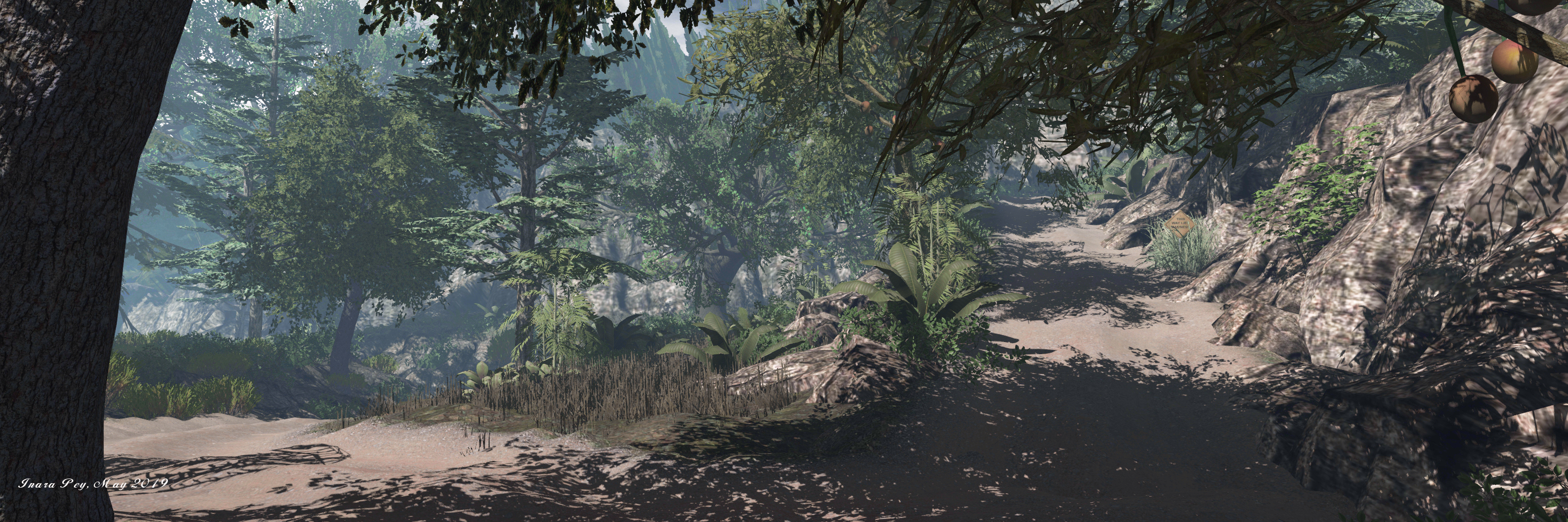
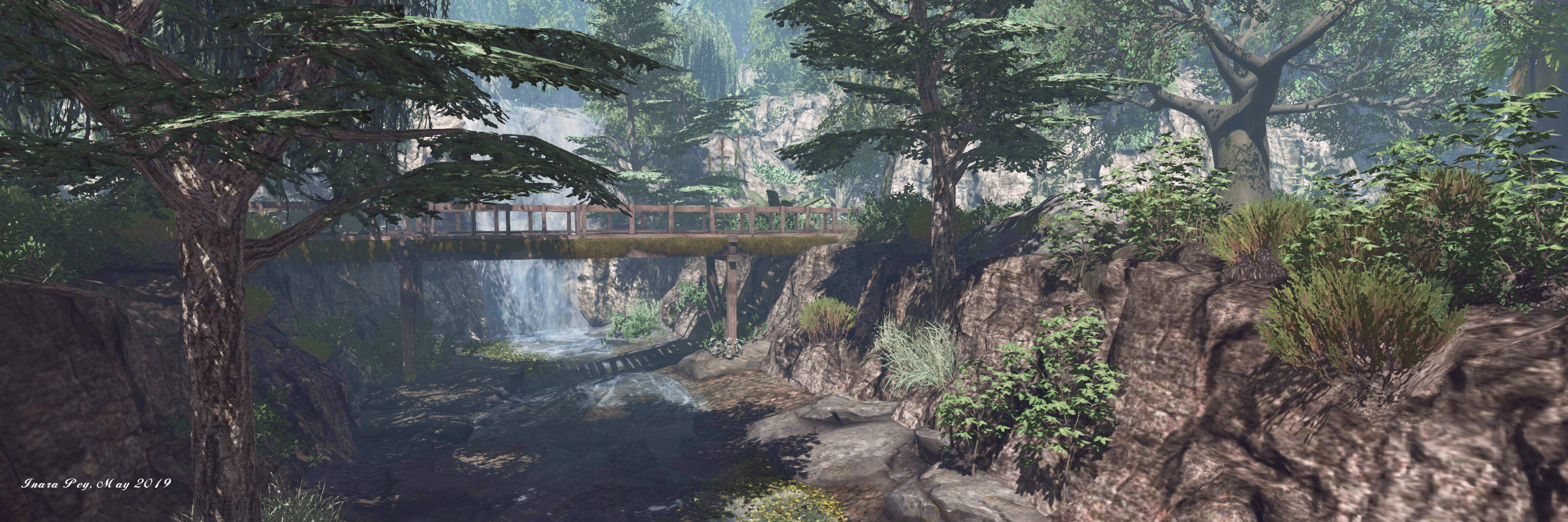
The landing point sits towards the middle of the region, on a long south-pointing finger that extended itself from the eastern side of the largest of the region’s three islands. A low, cinder-beached promontory rising from calm seas, the headland is dressed as something of an aged garden, completed with greenhouse (the landing point) and paved terrace before it. To the north sits an dry stone wall with tired iron gates marking the way to where the land rises up to a flat crown of fir trees in the midst of which sits one of the three rental properties.

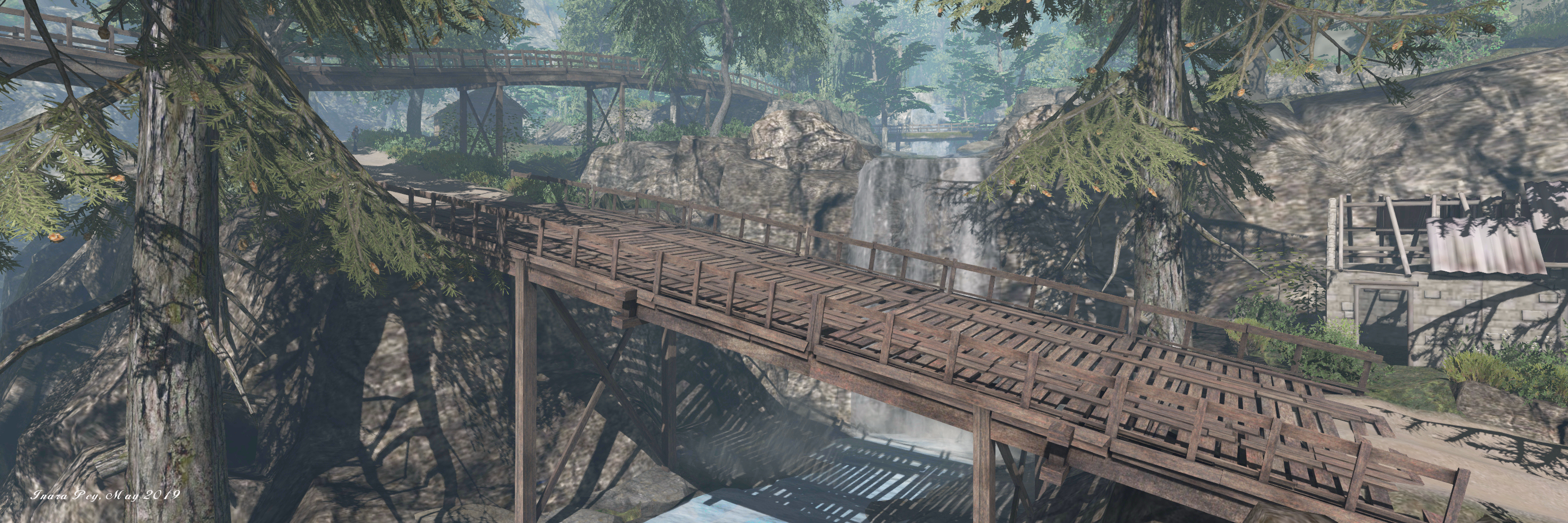
Two bridges sit on the headland, the first forms a double strand of wood and rope reaching across the inlet cutting inland by way of a little nub of rock, to reach a western promontory. Another cinder uprising, it sits a little higher than the landing points and offers the open space that could potentially be used by another house. For now, however, it is topped by trees and a small wooden deck, stone steps leading down to a rough, dark beach on the seaward side.

Iona Shore; Inara Pey, June 2019, on FlickrIona Shores, June 2019

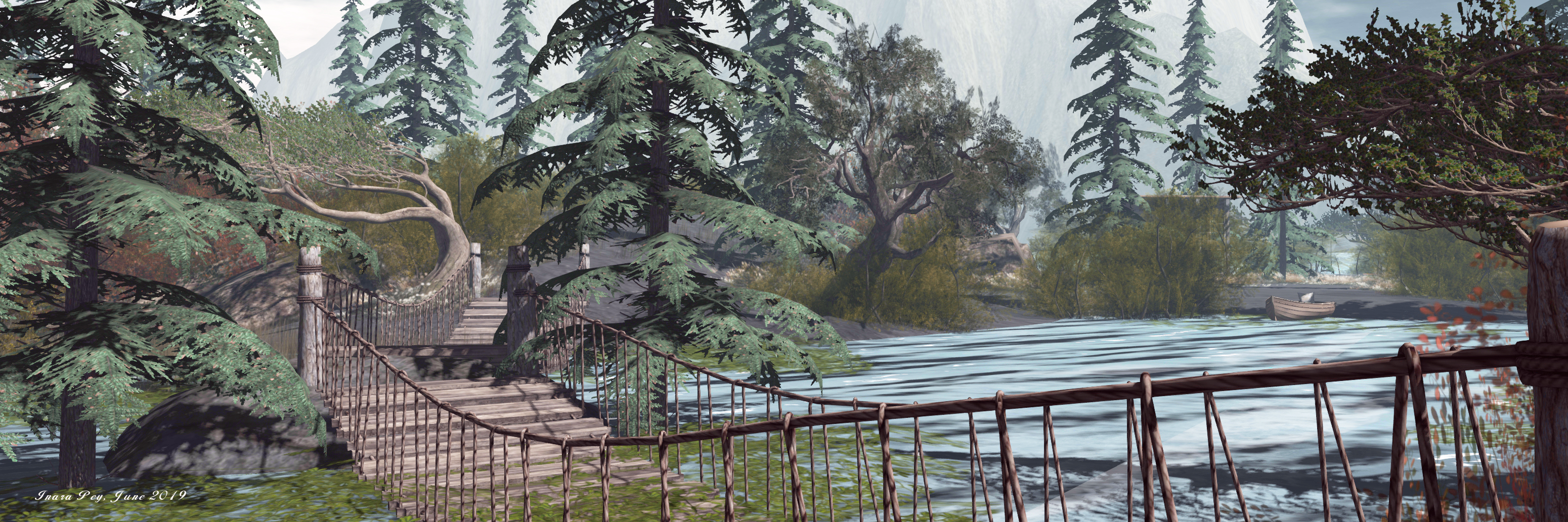
The second bridge reaches across a sliver of water to where rocks step their way up to a broad plateau where sits the second of the rental homes. The base of this island offers a public path around the south-west of the rocks, passing stepping stones that breach another tongue of water to reach the three of the larger islands, the home to the remaining rental house.

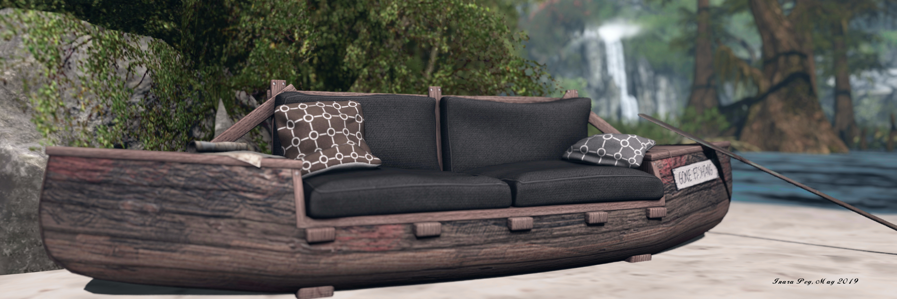
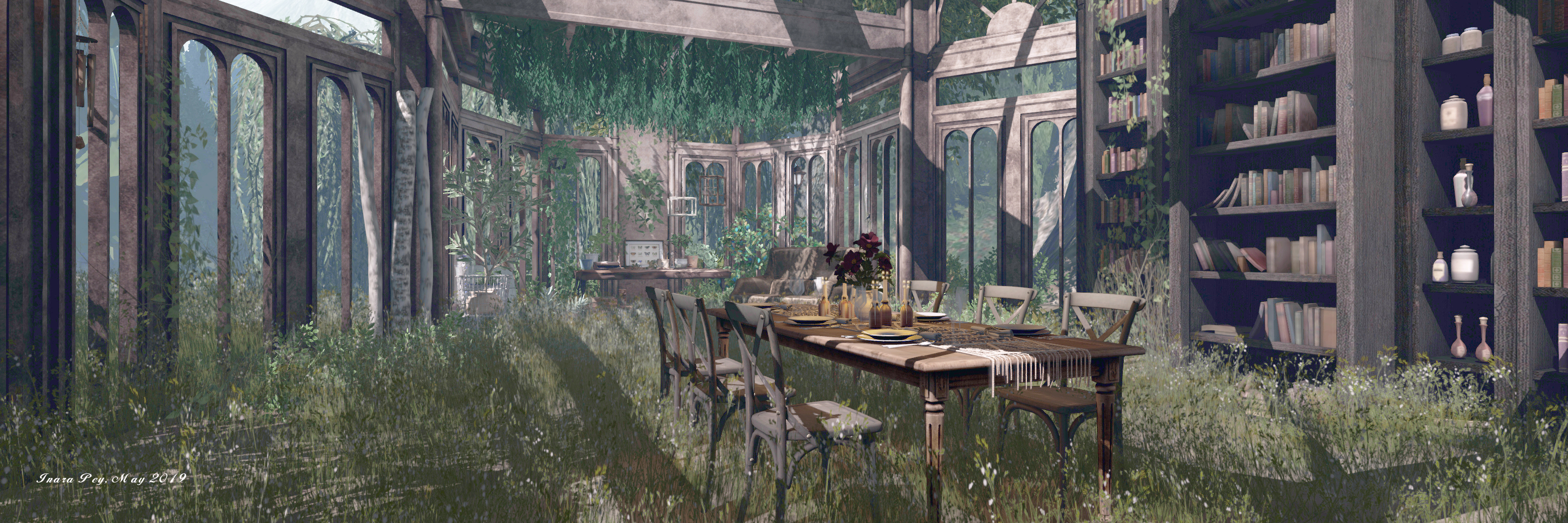
Throughout all of this, there are places to discover: a little studio space, a rowing boat offering singles and couples seating, horses grazing on the scrub grass, while wolves and deer wander parts of the landscape. All of this is watched over by the revolving eye of a lighthouse as trawlers chug by on the waters below it.

Iona Shore; Inara Pey, June 2019, on FlickrIona Shores, June 2019

Finished with a gentle sound scape, Iona Shores makes for a photogenic and visually pleasing visit. For those seeking a place to living that offers space and a feel for the wilderness, it come offer the ideal home. For the rest of us, it presents a delightful sense of escape.

SLurl Details

The return of Calas’ Santorini in Second Life

New Santorini; Inara Pey, June 2019, on FlickrNew Santorini, June 2019 – click any image for full size

Once upon a time within the Calas Galadhon park regions lay a tribute to Santorini, the largest island of a archipelago in the southern Aegean Sea. Officially called Thira (Thera in classic Greek), the island is world-renowned for the brilliant, white-washed walls of its buildings – most keenly, perhaps, exemplified by photographs of the principal city, Fira.

Obviously scaled-down, the Calas tribute to Santorini was nevertheless a marvellous build. So, when in 2014, Ty Tenk and Truck Meredith, owners of the Calas park regions, announced the Santorini build would be closing at the end of  that year (see A farewell to Santorini, December 2014), the news was greeted with disappointment among Calas Galadhon fans – myself among them.

New Santorini; Inara Pey, June 2019, on FlickrNew Santorini, June 2019

However, in April 2019, Tapped me with a photo of him standing in one of the Santorini terraces looking up at the distinctive houses and with the comment, “Just thought you’d enjoy seeing what we are working on 🙂 still a big secret but I know you loved the original ..all mesh 🙂 “. To say I was excited would be an understatement.

The new build – called, appropriately enough, New Santorini – was unveiled by invitation only on May 25th, 2019 – and Caitlyn and I were fortunate enough to be along those invited, although we were like all the guests, asked to keep quiet about what we saw until after the public unveiling, which took place on the weekend of June 1st / 2nd, 2019.

New Santorini; Inara Pey, June 2019, on FlickrNew Santorini, June 2019

Located on the Calas “holiday regions” of Eriador and Erebor, New Santorini recaptures almost everything from the original (although the waterfront café / events area has been replaced by a new open-air events area called Phoenix, sitting across the water from the main build, and within Erebor (Santorini itself lies within Eriador). However, being mesh and finely designed and implemented New Santorini offers much for explorers to discover both within its whitewashed walls and on and under the surrounding waters.

The landing point lies off to the east side of the region, within a semi-submerged cave. Follow the signs, and you’ll be led from this cave to a watery footpath that will present you with your first view of Santorini and the new events area (you may have to pump your draw distance up to see both, if your computer can handle things). This paths passes the gateway and steps leading down to the submerged gardens of Thera – an attraction in their own right, and again seeing a happy return (with a few revisions) as an ideal for merfolk to enjoy – although folk with legs are free to explore them as well.

New Santorini; Inara Pey, June 2019, on FlickrNew Santorini, June 2019

The town offers a lot to see: terraces offer places to sit and to dance, stairs climb between houses and buildings, plants offer bright bursts of colour and cafés beckon the weary. Around the base of the main island and on the surrounding islets are hints of a much older civilisation, echoing Minoan Thera. Some of these are best seen from the automated boat tour around the islands that starts at the Santorini end of the long, low causeway linking the island with the Phoenix events area.

One aspect of the town that should not be missed is the updated interiors of many of the houses. These represent a fine mix of different historical / cultural styles that are a complete delight to see, each one decorated, I understand, by Truck.

New Santorini; Inara Pey, June 2019, on FlickrNew Santorini, June 2019

Just how long new Santorini will remain is uncertain, and Ty candidly informed me.

We weren’t sure how we were going to show it off. We wanted it to be a special build, but we weren’t sure people would let us pack it up! But these are the regions we use for the holidays and our other special builds … although [as] both [Erebor and Eriador] are full regions now, we could put our special sky builds above where we have the [Phoenix] venue now. I’ve kept scripts down on Erebor to make room for builds above, so we’re still mulling it over.

– Ty Tenk on the new Santorini build and the future

However, the fact that it is back is a cause for celebration, and if you never got to see the original build (first built back in the days when prims were everything), then I cannot recommend finding the time to partake an excursion to New Santorini enough.

New Santorini; Inara Pey, June 2019, on FlickrNew Santorini, June 2019

As it is, Phoenix will be the focus for all of the planned Calas musical events through June. These start on Sunday, June 2nd, at 14:00 SLT with Samm Qendra, and will include Reggie Sunset, Savannah Rain, Djembe Dragonfire, Voodoo Shilton, Antonio Galloway and Chapman Zane. There will also be two special themed FlyGearz events in June – Toga & Greek Mythology and Pirates. To stay informed of all Calas Galadhon events, be sure to check out the Calas Galadhon website and the Calas in-world group.

SLurl Details

The waters of Blaylock Island in Second Life

Blaylock Island; Inara Pey, May 2019, on FlickrBlaylock Island – click any image for full size

Occupying a Homestead region, Blaylock Island – Where Peaceful Waters Flow is a stunning design by Jaccy (Jaccaranda Jael) with the support of Magenta Silverfall and Tira Langur (Tira Yalin), that has rightfully been getting a lot of attention from bloggers and photographers of late.

The region presents a wonderful feeling of being on a remote, rugged island where the weather is such that it has encouraged the growth of a local rain forest which does much to canopy the islands rocky splendour, whilst the coastline presents a veritable tropical paradise.

Blaylock Island; Inara Pey, May 2019, on FlickrBlaylock Island

It is on the coast that a visit commences, the landing point being on a long tongue of land extending into the western sea, rocks and breakers to the north testifying to shallow waters there. further around this curve of sandy coast sits one of a three major dwellings on the region. These do not appear to be private residences, but given they appear to belong to Jaccy, Magenta and Tira, some circumspection when visiting might be in order if they are present during your explorations.

Blaylock Island; Inara Pey, May 2019, on FlickrBlaylock Island

This is a place defined by the action of water. The central peak and high cliffs of the island feature great falls of water that tumble into bays and channels that cut through the landscape, forming deep ravines and sand banked waterways that twist their way to more open waters whilst also splitting the land somewhat. These waterways can be navigated using the little motorboat awaiting passengers close to the landing point, and which will periodically re-rez.

For the more adventurous, the island’s cloud-wreathed peak offers a series of wooden platforms linked by steps. These climb around the mountain to a final platform where a zip line can be taken back down to a raft anchored with one of the island’s bays, a short wade / swim from one of the beaches.

Blaylock Island; Inara Pey, May 2019, on FlickrBlaylock Island

Amidst the verdant trees and undergrowth sheltering the waterways, visitors can find other points of interest – a houseboat moored among mangroves, tree houses sheltered from the waters falling from above by a great natural arch of rock, and a variety of wildlife from flamingos to seals.

Throughout it all are numerous places to sit an relax and appreciate the setting, as well as those options for exploration, all of which – together with the rich sound scape – add depth to Blaylock Island that encourages the visitor to tarry beyond a brief visit.

Blaylock Island; Inara Pey, May 2019, on FlickrBlaylock Island

This is another very different and very engaging region design that offers numerous opportunities for exploration and photography. Beautifully present, it is easy to explore without significant impact on the viewer, and one will worth taking the time to visit and appreciate.

SLurl Details

The Mill at Lemon Beach in Second Life

The Mill, Lemon Beach; Inara Pey, May 2019, on FlickrThe Mill, Lemon Beach – click any image for full size

Lemon Beach has seen many designs from various region holders over the years, some of which have been documented in this blog (see here, and here, and here and here, for example). The region is currently under the care of Sylvana Dench, who follows the tradition in offering it for the enjoyment of visitors as The Mill.

This is a wonderfully provincial setting that has hints of France about it, although to me it could perhaps easily be anywhere along the coasts of Belgium, The Netherlands, Denmark or Germany. Low-lying, the region, whilst a island, had an almost headland feel to it; a finger of land tickling the sea, a place where farmlands give way to sands and salt water.

The Mill, Lemon Beach; Inara Pey, May 2019, on FlickrThe Mill, Lemon Beach

The landing point sit off to the north-east, close to the edge of the region. A sign bids a warm welcome, framed by a small lighthouse sitting just off the coast. A further welcome is offered by a little café sitting close by, sitting under a thatched roof – although as we walked by, I couldn’t help but wonder if the smell from the fishmonger across the narrow track of a road might not be a little off-putting to patrons should the breeze be in the wrong direction!

A small cottage sits alongside the fishmonger’s barn, perhaps his home, while a larger house sits on a bend in the road, while the titular mill rises from a small rise in the land just behind the café and its little farm shop. Taken together, and with both sheep grazing on the coastal grass not too far away and the large meadow behind the house where horses frolic, this little grouping of mill, café and house all have the feel of being perhaps owned by the one family.

The Mill, Lemon Beach; Inara Pey, May 2019, on FlickrThe Mill, Lemon Beach

They, and the fishmonger’s house and barn, are not the only buildings here, however. Scattered across the landscape is a walled farmhouse, an old Tuscan-style villa converted to a place of business and another little cottage daintily fronted by walled flowerbeds, all awaiting discovery.

They are all easily reached by following the track that leads southwards away from the landing point. Meanwhile, and further westward, sit a couple of properties that might be holiday homes for those fortunate enough to be able to have a getaway sitting on the coast. One of these sits just off-shore to the south-west, and given it is within its own parcel, it might be intended for private ownership in the future – although at the time of our visit it was open to the public.

The Mill, Lemon Beach; Inara Pey, May 2019, on FlickrThe Mill, Lemon Beach

The second house sits above the western beach and is clearly set for private occupancy, as demonstrated by the ban lines that become visible should you stray too close. However, it shares a stretch of beach with plenty of room for wandering or sitting, and which also features a bar and what might be a cosy surfer’s shack. Surf boards (traditional and wind) sit on the shore, but aren’t open for public use.

With it sheep and cows grazing peacefully, horses enjoying the freedom of their meadow and with a delightful sound scape, The Mill offers an inviting visit with enough to see and appreciate without it feeling overcrowded or putting undue load on the viewer. Yes, there are a few details that could be tidied a little, notably some of the floating bric-a-brac around the antiques store (or perhaps that’s the influence of the slightly creepy doll sitting on one of the benches outside! 🙂 ), but these are small enough so as not to unduly spoil things.

The Mill, Lemon Beach; Inara Pey, May 2019, on FlickrThe Mill, Lemon Beach

And while the surf boards might not be available for use by visitors, this is an excellent place to for horse riding, if you have a wearable Animesh horse; while those who might be disappointed he surf boards can’t be used might want to keep an eye out for the little boat with an outboard motor, as it can be used for pootling around the coast; just keep an eye out for the odd Orca and bather!

Our thanks to Shawn Shakespeare for the LM!

SLurl Details

  • The Mill (Lemon Beach, rated: Moderate)

Offering Atonement in Second Life

Atonement; Inara Pey, May 2019, on FlickrAtonement – click any image for full size

Update, August 20th: Atonement has closed and the region cleared. SLurls in this article have therefore been removed.

Occupying the full private island aptly named Canyon Creek, and making use of the additional full region land capacity bonus, Atonement is a relatively new – and utterly stunning – rental / public region.

We were pointed towards it by a number of friends, including MorganaCarter, Miro Collas and Shawn Shakespeare – and our thanks to everyone who did so.

Atonement; Inara Pey, May 2019, on FlickrAtonement

Designed by Aiden Caudron and Zomborg Vollmar, the region comes with an intriguing description:

An overgrown forest sim that has been abandoned overtime leaving homes buried between thick brush and twisted vines. You can find residential properties scattered around the sim with enhanced privacy provided by mother nature. Hidden caves leading to special destinations within the sim. Blogger friendly.

Atonement; Inara Pey, May 2019, on FlickrAtonement

This is a region that is perhaps best not described as experienced. Represented a mountainous region, far off in the wilds, it’s easy to imagine coming across Atonement in the Rockies of North America, and its elevated setting is given an added sense of depth through the careful positioning of region landscaping and sim surround, such that from most viewing angles within the region, the two appear to blend seamlessly together in to whole as the mountains rise beyond the tree line.

Falling from east to west in a series of tiers, a single narrow gorge, feed by tumbling falls and fast-flowing waters, the region is as the description states: richly forested and with a feeling of abandonment. The road winding through it is unpaved, footpaths are bare rock, the grass tall and wild where trees aren’t casting their shadows. Throughout all this are houses and buildings that have all seen better days, the bridges offering links between roads and paths looking as though they could perhaps benefit from a little TLC.

Atonement; Inara Pey, May 2019, on FlickrAtonement

Many of the houses are available for rent – so exploring with care is advised to avoid accidental trespass should any be occupied at the time of a visit. Elsewhere – such as the local pub – which most certainly has seen better days – there are twists of whimsy and humour that when discovered, are an unexpected delight.

Perfectly photogenic, the region’s mystique is given further depth by the question of why it should be here. Why locate a small town so deep in the rocky wilds? Perhaps the answer lies within the network of tunnels and caverns awaiting discovery  – be sure to accept your torch at the landing point. While appearing entirely natural, there is a hint that perhaps they might have once been worked, perhaps for mining gold or silver or something else equally enticing to the hands and pockets of humans.

Atonement; Inara Pey, May 2019, on FlickrAtonement

Although to be found throughout the region are places t be enjoyed when visiting, such as the rusting metal carcass of an old observatory far up at what is effectively the region’s peak: a table of rock that the old conservatory shares with a radio mast. Within the old frame can be found a cosy setting that is both at odd with, yet complimentary to, the overgrown interior of the old building. Elsewhere, those who explore far enough might find a games room / clubhouse, and there’s also the aforementioned pub.

Beautifully conceived and executed, Atonement can be a little taxing on systems if you’re running with a lot of the viewer’s bells and whistles active. however, it more than counters for this with its detail, unique approach and highly photogenic nature.

Atonement; Inara Pey, May 2019, on FlickrAtonement

Kun-Tei-Ner: a water world in Second Life

Kun-Tei-Ner; Inara Pey, May 2019, on FlickrKun-Tei-Ner – click any image for full size

Update: in keeping with Lotus and Fred offers different regions designs through the year and at different locations, Kun-Tei-Ner has closed. Slurls have therefore been removed from this article.

Kun-Tei-Ner is the name of the latest region design by the combined talents of Lotus Mastroianni and Fred Hamilton (frecoi). Between them, Lotus and Fred have been core parts of the design teams behind the likes of The Missing Whale (see The Missing Whale in Second Life), Little Havana (see A trip to Havana, with a little Voodoo In My Blood) and, most recently HoPe (HoPe: a world without humankind). In some ways, Kun-Tei-Ner, which opened on May 19th, 2019, is a continuation of HoPe.

With HoPe, we were presented with an environment that had suffered some kind of catastrophe, at least one part of which appeared to have been some form of natural disaster. In Kun-Tei-Ner, the theme of the natural disaster / event is continued, with the world apparently having suffered a massive ecological and environmental change, leaving it pretty much a water world, as the description of the region explains:

This is a place years ahead of us with no land. Humans have produced a lot of things…and many things are [now] useless. A city grows up on a huge mountain of containers filled with broken technological stuff, abandoned or fallen from ships.

Kun-Tei-Ner; Inara Pey, May 2019, on FlickrKun-Tei-Ner

And so it is that we are invited into one of the most unique and original environments currently to be found in Second Life: a marvellous mini archipelago of tall, close-packed islands rising from the sea, built from shipping containers gathered from who-knows-where, brought together to create the shoreline, hills, apartments and places of commerce this corner of humanity’s survivors treat as home.

Stacked together like Lego® bricks – and almost as colourful – the containers form everything one might expect from a close-packed group of islets: there are high peaks, valleys, ocean fronts, low-lying “flatlands” … Yes, all are obviously painted metals, but attempts have clearly been made to make things look more natural and return a hint of nature to the setting, with ivy and vines strung from the sides of some containers, well clear of where they might otherwise be splashed and contaminated by salt water.

Kun-Tei-Ner; Inara Pey, May 2019, on FlickrKun-Tei-Ner

The containers that have been converted into homes have had holes cut into their sides or have had their end or doors removed, the holes replaced by wooden frames, sliding doors, and windows cut from what looks to be sheets of acetate plastic. Others offer places of commerce: a pizza bar here, an little Japanese-style food market there ….

These, with their lit neon signs, at first look incongruous given the overall theme of the setting, but it is clear that power is not an issue here: the upper reaches of the container “hills” are lit by flashing neon billboards, and someone has taken the opportunity to place traditional wooden advertising hoardings up as well. Perhaps some of the power for the neons signs comes from the wind turbines sitting just of the “coast” of these iron islands, but there are signs of other industrial activity as well: great pipes rise from the waters to plug themselves into containers, while others run from one set of containers to another as a tall smoke stack belches orange smoke to drift in the wind.

Kun-Tei-Ner; Inara Pey, May 2019, on FlickrKun-Tei-Ner

It is clear from this that there is some form of heavy plant hidden within some of the stacked containers. Does it provide power? is it helping to grow foodstuffs hidden by corrugated steel walls? That’s up for you as a visitor to decide. There are other signs that technology has survived as well: a large satellite communication dish points its eye towards a spot in the sky, while a satellite receiver appears to be obtaining video signals from another orbital system.

Finding your way around the islands is a matter of following the LED arrows on the floors and walls of the containers, while bridges formed from wood and rope, open-ended container and metal gantries connect the different islands. The arrows point to multiple routes and passages around the islands, making exploration a walk of discovery, at least some of which is observed from above by a flying sculpture of a whale shark.

Kun-Tei-Ner; Inara Pey, May 2019, on FlickrKun-Tei-Ner

The paths offer a lot to see, from the interiors of the living containers, to the food market and pizza bar to multiple places to sit, indoors and out. They can also offer plenty of opportunities for photography.. Just be sure to give the region the time it deserves when visiting.

The region designs by Lotus and Fred are generally available for around a month before they kick-off their next project. So, in case that will be so for Kun-Tei-Ner, a visit sooner than later might be advisable to avoid missing what is – as noted – a fascinating setting worthy of exploration.