The sands of Banana Bay in Second Life

Follow Your Bliss, Sea Foam; Inara Pey, July 2017, on Flickr Banana Bay – click any image for full size

Banana Bay is a Homestead region described as “still under construction” (but open to the public) designed by the delightfully named Bananas (FunkyBananas). Caitlyn and I were led to it (once again) by Shakespeare (SkinnyNilla), who really does have the knack for finding places.

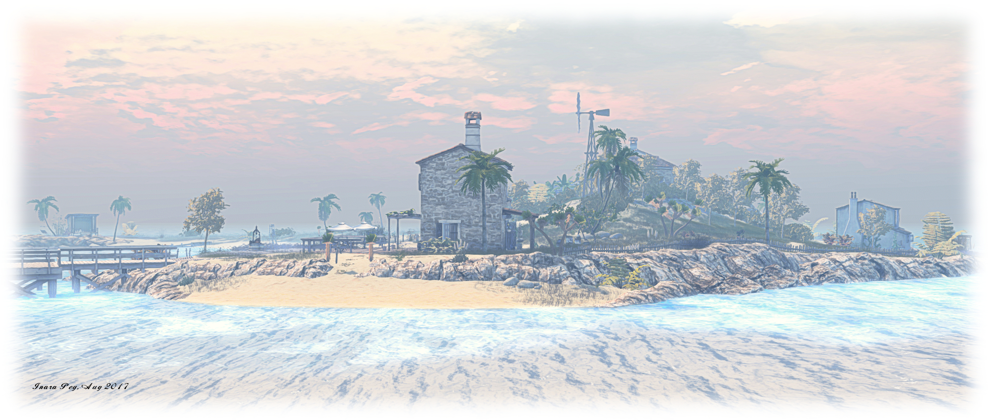
This is a  distinctly Mediterranean setting with a hint of the tropical; the kind of place it’s easy to imagine  as the destination for an exotic holiday well out-of-the-way of the maddening crowds and bustle of everyday life. A slightly curled, sandy island with an east-facing bay caught within its curve, Banana Bay appears to take its name from the little plantation of banana trees located almost mid-way along its sweep, overlooked by one of several Tuscan / Mediterranean style buildings scattered along the island.

Follow Your Bliss, Sea Foam; Inara Pey, July 2017, on Flickr Banana Bay

Visits start on the west side of one of these buildings, which is itself located at the northern end of the island. A sandy path runs southwards from here, following the line of rock which rise from the foam of a lazy sea to reach another house sitting below the hilly backbone of the island. It’s upon this partially rocky backbone that the plantation sits, the land on the west side offering an easy walk to the southern end of the island and the ribbon of beach curling eastwards.

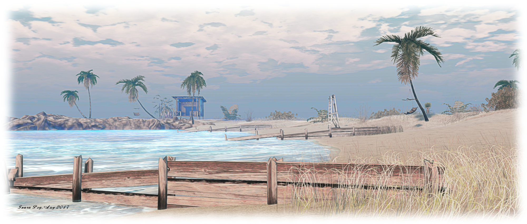
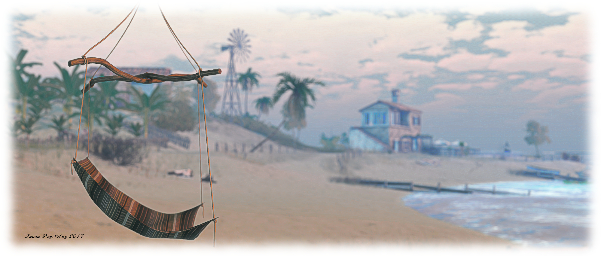
Following the sandy walk in the other direction from the landing point will take visitors around the villa to where a large wooden pier points out to sea. A loose-laid wooden board walk then offers a path south, running between the soft sands of a wide beach and the slopes of the island’s one hill, before petering out on the sands to the south. Palm trees offer some shade from the early morning sun, and provide convenient points from which hammocks have been slung for those wanting a little rest and they explore. More places to sit, some ready for cuddling, can be found scattered across the island, including an old kayak drawn up high above the tide line on the beach, and an inflatable raft out on the surf.

Follow Your Bliss, Sea Foam; Inara Pey, July 2017, on Flickr Banana Bay

None of the buildings are currently furnished, although the villa near the landing point offers outdoor seating. There’s also no sound scape for the region as yet – but again, remember that it is under construction, so there well be more to come.

Under construction (at the time of writing) it may well be, but Banana Bay is  already and photogenic and restful setting; the fact that it is still being developed means that it’ll be remaining on our list of places to re-visit sooner rather than later in order to see how things are progressing. In the meantime, if you want to have a break from things and drift away from all the noise about Sansar or whatever, why not take a walk along to beaches of Banana Bay?

Follow Your Bliss, Sea Foam; Inara Pey, July 2017, on Flickr Banana Bay

SLurl Details

  • Banana Bay (Charmed One, rated: Adult)

Following an Oriental Bliss in Second Life

Follow Your Bliss, Sea Foam; Inara Pey, July 2017, on Flickr Follow Your Bliss – click any image for full size

June 2017 marked just over a year since Caitlyn and I last visited Follow Your Bliss, the homestead region designed by ElizabethNantes. Given this, we felt it was high time we made a return. Back then, the region had the distinct feel of a tropical archipelago, and we were keen to see what changes had been wrought in the intervening months.

For the current build, Elizabeth has adopted the Display Name Sushi – and on arrival it is immediately obvious why this should be: the region is now distinctly Japanese in looks. However, while many region designers opt to focus on a period build when turning to Japan – notably settling on the Edo period – Elizabeth offers something different: a mix of the old and the contemporary, gathered around a watery setting.

Follow Your Bliss, Sea Foam; Inara Pey, July 2017, on Flickr Follow Your Bliss

Set beneath an early evening sky, Follow Your Bliss presents a mainly low-lying series of islets surrounding a shallow body of water on which sampans float and waves are rippled by a gentle breeze. To the east, the land rises into a more substantial mass, formed by rocky shoulders and gently rolling slopes. Along this ribbon of land sits a row of little shops, some with traditional slope tile roofs, others box-like structures of concrete and wood, flat-topped and decorated with neon signage and adverts for popular brands.

A cobble footpath separates these shops from the waters of the shallows, running from a point just a short walk from the landing point to where an ancient  – and clearly venerated  – olive tree grows. At the southern end of this path, the route back to the landing point, located in a small summer-house also overlooking the shallow waters, is marked by a series of candle lanterns. Some of these manage to remain lit despite being caught in a gentle fall of rain, sitting close to a marching line of Torii gates which climb a hill, pointing the way to a pagoda and to where Buddha sits on a grassy curve of hill-top.

Follow Your Bliss, Sea Foam; Inara Pey, July 2017, on Flickr Follow Your Bliss

Looking towards the west, Buddha stares out over the waters of the region and the loose-knit chain of little islands which run northwards from the landing point towards a dense grove of bamboo. Connected by wooden bridges, these little islets  offer places to sit and relax and perhaps join Buddha in quiet meditation as he looks down on you.

At the bamboo grove, which screens the main part of the region from was might be private residence, the path passes a temple bell and arcs more eastwards in its direction, passing a strong pavilion built out over the water. Beyond this, another little house straddles the water separating the western aspect of the region from the ancient olive tree and the little township beyond it.

Follow Your Bliss, Sea Foam; Inara Pey, July 2017, on Flickr Follow Your Bliss

With the ground a particular course grain of cinder earth, the chain-like beads of land surrounding the inland water as they run from the southern edge of the rockier ground and out to the west before turning back inwards to come back to the northern end of the land’s long finger, the entire impression is that this the site of an ancient crater – perhaps even the small caldera of a long extinct and flooded volcano, the land all that remains of the crater rim.

Finished with a gentle ambient sound scape of falling rain and birdsong, the splashing of water and the burring of dragonfly wings, Follow Your Bliss offers a relaxing setting, easy to explore and enjoy  – and even the chance to sail a sampan. An altogether delightful little visit.

Follow Your Bliss, Sea Foam; Inara Pey, July 2017, on Flickr Follow Your Bliss

SLurl Details

Welcome to Somewhere in Second Life

Welcome to Somewhere, Salmson Isle; Inara Pey, July 2017, on Flickr Welcome to Somewhere – click any image for full size

Update: July 28th: Zoe Connolly produced a video of Welcome to Somewhere, which say says was inspired by this blog post. It’s a delight to watch, and I’m embedding it at the end of the post with thanks to her. I’ll hopefully be back to making my own videos at some point in the not too distant future!

It’s a catchy name for a place: Welcome to Somewhere, the Full region designed by DarkDesire (Stefan Salmson) and Petra Teatime (Petra Hienke) – and it is certainly appropriate. This is an enigmatic location; on the one hand strange and new, on the other, containing just enough familiarity about it to suggest is it somewhere you may have been to or seen before. Caught in an eternal twilight which adds to the general atmosphere when exploring (although I admittedly opted for daytime pictures in the hope of showing a slightly different face to the region), Welcome to Somewhere is a place of charm and mystery, where hints of dark secrets lay without ever their true nature being overtly revealed.

If you follow the given SLurl, your visit will start on the north side of the land, marked by houses, cottages, a house boat and a warehouse place of work. Everything is a little run-down, suggesting this is a place that’s seen better days – there’s even the sad hulk of a sunken trawler partially blocking access to the quayside for other vessels.

Welcome to Somewhere, Salmson Isle; Inara Pey, July 2017, on Flickr Welcome to Somewhere

Find your way ashore, and a dirt track points west from the back of the wooden warehouse-come-store / place of work, directing you along the coastline before turning south and delivering you to what remains of a fun fair. Overgrown, the rides broken and decaying, the fair has the edge real edge to it: the clown’s fang-filled smile at the gate not entirely a promise of jollity within. A Ferris wheel, long broken and rusted, stands sentinel over two foot bridges. One faces east, towards some old stone ruins where sits a little tram-car converted for use as a tea shop, its innocence standing in contrast to the darker hints of the fun fair. Deeper within the ruins is forgotten outdoor stage, resuming the air of foreboding about this place.

The second, smaller foot bridge leads to two imposing houses facing one another across paved and ordered gardens, complete with an orangery housing a harpsichord, a little outside café alongside it. Sitting between low shoulders of rock, these distinguished houses and their gardens give a sense of money and order, their status perhaps once the dominant feature in this landscape.

Welcome to Somewhere, Salmson Isle; Inara Pey, July 2017, on Flickr Welcome to Somewhere

Another track winds its way east from here, skirting the edge of the large lake occupying a far portion of the land before passing a slightly dilapidated  farmhouse and over another foot bridge to where tall Scotts pines grow, the path gently undulating between them. At the end of this path sit more buildings, exuding an air of menace  – something greatly increased by the puppet theatre parked at the water’s edge. There is something disturbing about this; it appears neither friendly nor welcoming – one could almost imagine the Child Catcher from Chitty Chitty Bang Bang waiting to usher unsuspecting souls inside, before dropping the bars across the entrance and trapping them.

It is this air of menace – or at least the feeling this place has a darker side to it – which adds greatly to the overall feel to the region when exploring it under the low light of dusk. It sharply contrasts with the beautifully picturesque nature of the landscape (best appreciated in daylight). The latter presents calm waters, shaded walks, gentle hill climbs to follies and a little hilltop function room (perhaps once the scene of happy Sunday afternoon dances), but as one travels, so the delight the the landscape become tinged with that frisson of discomfort, the urge to look over your shoulder when walking the path to the odd little puppet theatre.

Welcome to Somewhere, Salmson Isle; Inara Pey, July 2017, on Flickr Welcome to Somewhere

Just where is everyone? Some of the region feels as find it has been run-down a left to decay for a long time – notably the fun fair. Other parts feel as if they’ve recently fallen on hard times. But so too is there a feeling that the locals have only fled, leaving only the wildlife – and the dolls. These are to be found scattered around, indoors and out. do they mean anything? That’s for you to decide. And what of the strangeness of the little hamlet where explorations of the region begin? Why is it that it has a roadside auto shop where no road has seemingly ever run?

Whether you seek to answer these questions, and any other which might occur to you as you explore Welcome to Somewhere is entirely down to you. One thing is undeniable about this place, however. It is an enigmatic delight to visit, offering numerous opportunities for photography and lots of room for meandering discovery of all it has to offer.

Welcome to Somewhere, Salmson Isle; Inara Pey, July 2017, on Flickr Welcome to Somewhere

SLurl Details

Ash Falls in Second Life

Ash Falls, Picture Perfect; Inara Pey, July 2017, on Flickr Ash Falls – click any image for full size

Updated, September 4th: As per the comment below, Ash Falls now requires the payment of a group joining fee in order to access the region.

Ash Falls is a homestead region build by Leaf and Birdy Moone, and it is an absolute delight to visit. Softly lit by the last rays of a lowering Sun, setting slowly to the south, such is the sheer beauty of the region it deserves to be seen both under its natural windlight (Bryn Oh’s Mayfly) and something a with a little more daylight.

A v-shaped island facing the south-east, cradles a broad, flat beach within its rocky, wooded arms. But this is not the familiar sandy beach so often seen throughout Second Life; it is a cinder beach, the sand dark and course, suggestive of having been created over the ages from the aftermath of many volcanic eruptions. Behind it to the north and east, the rugged backbone of the island offers paths and tracks to be followed, shaded cuddle nooks to be found  – and more besides.

Ash Falls, Picture Perfect; Inara Pey, July 2017, on Flickr Ash Falls

The landing point sits at the end of the northern arm of the island’s rocky V, a stone terrace of some age, with walls partially bracketing it on two sides. A short walk from here in the evening’s light, are wrought iron gates offering access to a broader terrace, complete with parasolled seating, quiet water features and a splashing fountain.

A grassy avenue points the way eastwards, lit by tall lamps and bordered by thick bushes. A set of wooden steps just to the right at the start of this path presents a way down to the beach, while the end of the trail is marked by a wooden platform overlooking a deep, square quarry, long disused and now semi-flooded. Water drops free and clear from falls to one side of this square basin, while lanterns drift and turn on  eddies of air, floating over another platform built over the waters of the quarry.

Ash Falls, Picture Perfect; Inara Pey, July 2017, on Flickr Ash Falls

A coffee-house sits at the edge of the small inlet cutting into the beach, straddling sand and the gentle wash of the tide. It offers seating inside and out, and is watched over by cuddle spots further up the beach towards the rocky uplands. Head east along the beach, and you’ll pass a narrow opening cut through the rocks providing access to the old quarry. Not far from this is a slope leading up to an old shack and barn, perhaps once associated with the quarry, but now evidently a home to someone. Follow a grass path between tall fir trees from here, and you’ll discover another snuggle spot and steps leading down to a little cove caught in a very localised rain storm!

Further around the beach, east of the slope leading to the old shack, are wooden steps offering the way up to another path. This runs up between a line of rock on one side and a high-banked slope on the other to where a much grander house sits upon the eastern headland. Both this house and the shack are open to the public to explore, and a further trail curls away from the area in front of the house, leading the way to a cosy outdoor theatre, surrounded by trees and bushes.

Ash Falls is a beautifully scenic setting, perfect for photography, exploration, and simply wandering  / sitting. It’s perfect for a getaway, and ideal for resting the mind.

SLurl Details

  • Ash Falls (Picture Perfect, rated: Moderate)

An oriental Collins Land in Second Life

Collins Land, Collins Land; Inara Pey, June 2017, on Flickr Collins Land – click any image for full size

I was stunned to realise that it has been almost four years since I last visited Collins Land, the home of Cerys Collins (Cerys Celestalis). In fact, it has been so long that in the intervening time, Cerys has moved from at Homestead to a Full region. The current build has been in progress since May 2017, with Cerys noting it is now “95% complete”.  Having learned of the Japanese-themed redesign by way of my favourite region hunters, Shakespeare and Max, Caitlyn and I had to leap over and have an explore.

Following the region landmark will deliver you to a shaded spot south and west of the region’s centre, and the grounds of a large traditional Japanese house, built over the cooling influence of a large pond. The latter is an indication that water plays a subtle but important role within the region – keep an eye out for how Cerys makes use of it throughout. The house is situated to one side of tiered gardens and grounds, all of which tend to form a good starting point for explorations.

Collins Land, Collins Land; Inara Pey, June 2017, on Flickr Collins Land

Wooden paths wind and fork their way through the grounds, offering a number of points of entry into the house as well as leading to other points of interest. Follow these board walks with care: just when you think you’ve found them all, the likelihood is you’ll find another leading you to a little scene, a part of the whole whilst also feeling entirely secluded. One route, for example, leads way to a little shaded summer-house to the south overlooking a beach; another route offers access to another little group of buildings in the south-west corner of the island, where a Koi house sits over another pool of water.

Close to the landing point lay stone steps climbing up into the region’s highlands. These are, like a number of the major paths around and through the region, marked by a torii gate. The steps wind their way up to a high plateau, where sits a Buddhist shrine protected by a moat and walls. Along the way, you’ll pass through bamboo groves and past a Machiya house. As well as offering a break from the climb, the gardens of the house offer a view west and north, emphasising the verdant nature of the region.

Collins Land, Collins Land; Inara Pey, June 2017, on Flickr Collins Land

The shrine isn’t the highest point on the island, however. That honour goes to the pagoda in whose shadow it might sometimes sit. This pagoda can be reached by scrambling over the rocks, but there is a fabulous climb via wooden walkways which winds its way up the side of the cliffs, after also starting from the gardens of the landing point. This route – its start denoted by another of the torii gates – should not be missed, and offers more views out over the surrounding mountains.

On the north side of the region, sitting under the massif, is a small village, reach by following yet another wooden footpath running northwards from the main house near the landing point and along the west side of the region – watch for the pleasing little detours off of this again along the way. This path gently climbs down the rocky shoulder of the island to reach the village by way of a bridge separating another inland pool from the waters surrounding the region. Built over cobbles and stones, the village appears to be devoted to farming and fishing, and visitors are welcome to try their hand at Greedy, Greedy if they so wish.

Collins Land, Collins Land; Inara Pey, June 2017, on Flickr Collins Land

The lowlands of the northern village are matched by the beach to the south, once again reached by steps leading down from the gardens and house at the landing point. Follow the stepping-stones here and you’ll uncover one of the region’s secrets. As noted, there are others awaiting discovery, as is a hidden place – although I’m not 100% certain that is intended to be open to the public.

I really cannot over-emphasize the beauty of this iteration of Collins Land. The colours are rich and vibrant, the landscaping beautifully and painstakingly done, the beauty spots numerous, the hidden places intimate, the use of space exquisite – as is the way the paths and climbs naturally follow the contours of the land. Keep an eye out for the little touches of humour to be found dotted about in the ground in the water. This humour offers a nod to the fact the work is still ongoing: a group of artisans working (and resting!) as they ready the final bits…

All told, an absolutely gem of a region – as is always the case with Cery’s designs. Click the image below and scroll around the landing point in 360o. If you’re a Flickr user and take shots of the region, please consider sharing them with the Collins Land Flickr group.

SLurl Details

Gale Storm Retreat in Second Life

Gale Storm Retreat, Aphrodisia Isle; Inara Pey, June 2017, on Flickr Gale Storm Retreat – click any image for full size

Gale Storm Retreat is a Homestead region designed by Chania Leuce (CheekiChica). It adjoins the full region of Aphrodisia, home to Chania’s store and which, at the time of writing, is listed as “under construction. The landing point sits at the northern end of Gale Storm Retreat, serving both regions; a gated path leads up to Aphrodisia, while wooden signs point the way to the more open areas of Gale Storm Retreat.

As the descriptions for the region found in the Destination Guide and in About Land state, this is a remote location, modelled after the US Pacific North-west, where a storm is brewing just off the coast. In fact, the rain has already made landfall – so you might want a brolly and raincoat when visiting!

Gale Storm Retreat, Aphrodisia Isle; Inara Pey, June 2017, on Flickr Gale Storm Retreat

Follow the signs east and south from the landing point, and you’ll pass under a great stone arch, watched over by a wooden windmill, and you’ll find yourself on a high plateau which quickly drops away to the south and west to a sandy coast, where the tide appears to be on the rise. To the east, the land falls sharply away as cliffs, their edge guarded by rocky walls and slender fences.

Walk beneath the line of these eastern rocky walls- avoiding a slim finger pointing inland  – and you’ll find your way southward past a large stone patio with pool and tiled roof, the latter protecting a fire offering warmth and respite from the rain,  and down to a  rocky headland where the revolving eye of a lighthouse watches over land and sea.

Gale Storm Retreat, Aphrodisia Isle; Inara Pey, June 2017, on Flickr Gale Storm Retreat

Below the lighthouse lay the beach and sandbars of the coast, straddled in part by wooden houses raised on stout wooden piles to avoid the ravages of a returning tide. Huts and tents sit further in from the sea, huddled on the sands above the high tide mark, but still looking vulnerable as rain lashes down and lightening forks and flashes its way across the sky.

Further to the west and north, above the lie of the beach, but lower than the main plateau, sits a grassy bluff, home to a stone and wood cottage with smoke rising invitingly from its tall chimney, suggesting another place where shelter from the rain can be found. The cottage sits close to another line of cliffs to the north and which march back eastwards, part of the divide between the coast and the town on the neighbouring region. And old shipping container, converted into a hideaway, sits within the shadow of the cliffs, watched over by the weeping willows lining their narrow tops.

Gale Storm Retreat, Aphrodisia Isle; Inara Pey, June 2017, on Flickr Gale Storm Retreat

This is an atmospheric region, designed for photography and which lovers of the sea and the rain will enjoy. There are plenty of places scattered across the landscape for couple to enjoy, indoors and out – including in at least one of the tree houses. A group joining fee of L$500 secures rezzing rights and the ability to claim the pose gifts on offer at the landing point. Chania also notes that it is a work-in-progress (as with the region to the north), so don’t be surprised if details have changed between reading this description and any visit you make.

And about that region to the north? Well, it may be the subject of a future article, once Chania and her friends have had the opportunity to finish building it. Time will tell on that!

SLurl Details