The use of ChemCam on these rocks brought the total number of firings for the laser system to 25,000.
Other rocks in the area appear to be sedimentary sandstone, a further indicator of water action. The course graining of the sandstone again point to water having been the transport mechanism, rather than wind. Crystal-like grains have also been imaged in the sandstone using the Mars Hand Lens Imager (MAHLI), although how and why they formed isn’t clear at present, although one caused something of a stir on the Internet when released, given its resemblance to a tiny bud.

In all, the morphology of the area is proving fascinating to mission scientists not only because of the diversity of features present in the area, but also because the rocks layers represent a reasonable geological time span in Mars’ history, with the lowermost exposed rock beds, dubbed “Sheepbed” somewhat older than those such as “John Klein”, but nevertheless still showing typical characteristics of having water flowing through fractures and percolating through the rock, leaving mineral deposits in its wake. Whether or not the various strata of rock were laid down during one continuous wet period in the region’s history, or whether they were the result of the area experiencing a number of notably wet periods, has yet to be determined.

One of the reasons the “Glenelg” / “Yellowknife Bay” area attracted scientists was because of the clear thermal difference between the area and the region in which MSL landed. This difference in thermal inertia had been measured from orbit by Mars Odyssey, and so it was expected that Curiosity’s on-board weather station would measure some change in local temperature ranges as the rover entered the region. However, what had not been expected was the abrupt nature of the change, which occurred precisely as the rover crossed the boundary between the two terrain types on Sol 120/121 (December 7th / 8th, 2012), with the REMS weather station immediately registering a significant change in ground temperature ranges.
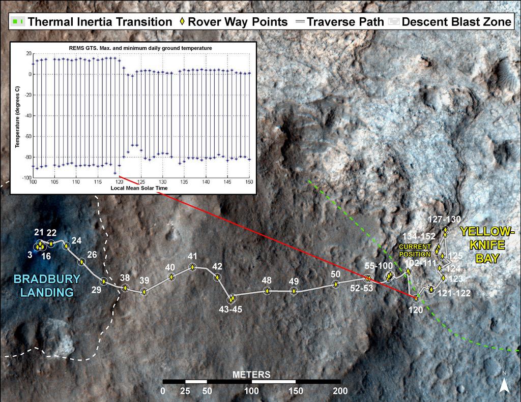
“It’s like we entered a whole different world,” Grotzinger said during the press conference. “We still don’t know what is causing this change in thermal inertia – that’s going to be a far more complicated problem to figure out … [But] we really can’t wait to get drilling on this stuff.”
Drilling into “John Klein”
That said, it is still going to be around two weeks before any drilling for the purposes of sample gathering is likely to take place. While a target has been selected for the first use of Curiosity’s drill, actual operations have been delayed while Curiosity continues to survey the area and carry out other tasks.

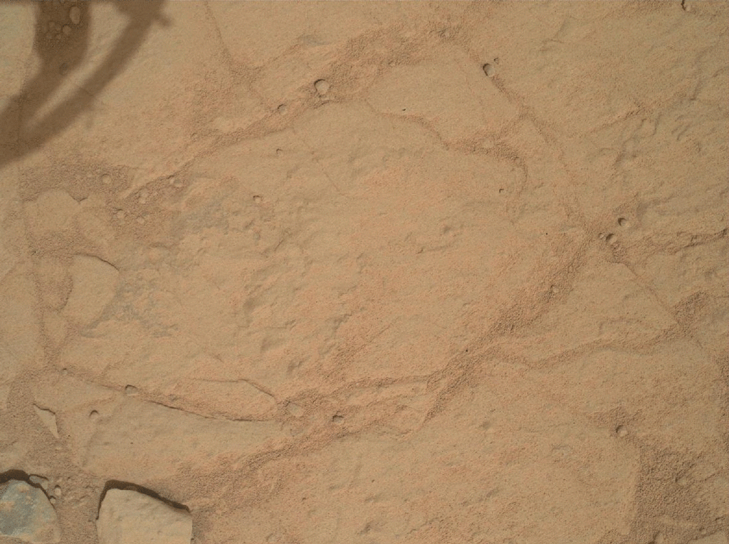
The target area itself is a rock outcrop forming a relatively recent feature of the area, and which has been dubbed “John Klein” in tribute to former Mars Science Laboratory deputy project manager John W. Klein, who died in 2011. It has been chosen due to the rich diversity of surface features evident. it is shot through with fractures and veins, with the intervening rock containing concretions (small spherical concentrations of minerals, similar in nature, if not necessarily in content, as those discovered by both Spirit and Opportunity elsewhere on Mars).
Before any samples gathered by the drill can be analysed by Curiosity’s on-board systems, the mechanism inside the drill used to pass core samples to CHIMRA for pre-processing must go through a “cleaning” process much as CHIMRA itself experienced, in order to remove possible contaminants from Earth which may interfere with analysis of the samples by CheMin and SAM.
Even when the drill systems have all finally been readied for action, gathering samples may be a more protected process than anticipated, as MSL Project Manager Richard Cook explained, “Drilling into a rock to collect a sample will be this mission’s most challenging activity since the landing. It has never been done on Mars. The drill hardware interacts energetically with Martian material we don’t control. We won’t be surprised if some steps in the process don’t go exactly as planned the first time through.”
Commenting on concerns about the percussive action of the drill eventually causing a malfunction, Cook emphasised that NASA is confident that the drill will operate throughout its anticipated lifespan and very possibly beyond. Furthermore, if the percussive action does cause electrical bond to break at some point in the future, mission managers are now reasonably confident the drill itself will remain operational as it is designed to work without the hammer action.
How long Curiosity will remain in the area has yet to be determined. “Mount Sharp” still remains the mission’s goal, but for now “Yellowknife Bay” remains the focus of attention.
Curiosity’s Team to Receive Space Foundation Award
The Space Foundation has announced that the team behind the MSL project is to receive their prestigious John L. “Jack” Swigert, Jr., Award for Space Exploration.
Created in 2004, the award, named in memory of Apollo 13 astronaut John Swigert Jr, is given annually to the person or organisation that has made the most significant accomplishment in advancing the exploration of space during the previous year. The presenation will take place at the opening ceremony of the 29th National Space Symposium on april 8th, 2013, in Swigert’s home state of Colorado.
Congratulations to the entire MSL team.
All images courtesy of NASA/JPL.
