A little rock climbing in Second Life

Rock climbing / free climbing in Second Life

A while back Yasmin (YouAintSeenMe) mentioned to me that she was considering a rock climbing system for Second Life. Being one who doesn’t particularly handle looking over the edge of extreme tall / high things in the physical world, it struck me that a) rock climbing would not be my first recreational pursuit, and b) but why not have a go in Second Life where bones don’t get broken?

So, armed with a follow-up note card from Yasmin on the subject, I toddled off to try out a climb she’s set-up on the west face of Nitida Ridge, Heterocera.

Nitida Ridge – 100m of cliffs to climb!

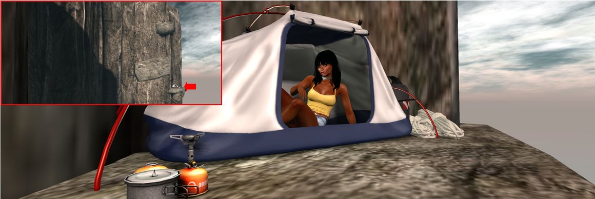
Here, at the foot of the ridge, sits a little base camp established by Yasmin, with tents, food and a warm fire. Close by is a sign that both introduces the climb(s) up the rock face and provides visitors with the necessary kit when touched. The latter is free, and comprises:

  • An abseil harness (worn invisibly, just ADD to attach to the stomach attach point); information on the climbing HUD, a note card on the routes up the cliffs – direct or extended; and an image of the cliffs overlaid with the routes up (green) and abseil descents (red).
  • The climbing HUD – clicking the sign will cause a pop-up asking for this to be attached so your avatar can be animated during a climb.
Starting my climb

The HUD attaches towards the lower right of your screen by default – although obviously can be repositioned.  It is colour-coded as follows: Blue (generally the default) = ready; Green  = active climb located / engaged; red = disabled. In addition, touch the HUD brings up a dialogue box. There are a handful of points to be remembered when climbing, and with the HUD in particular:

  • It is still an in-development system, so not all features may be present and the occasional bug might try to put you off your climb.
  • Not all the options on the dialogue box may be fully functional at present.
  • The ones you are most likely to want to use are the climbing speeds (Faster / Slower) and the avatar position options (In  / Out) – the latter to move your avatar either further away from the rock face (so you’re not up to your elbows inside the rock, for example, or climbing air).
Taking a breather and a look around at 170 metres above sea level and …. Eeep! It’s a long way down!

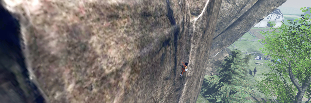
Climbing is a matter of finding the first pitch along the foot of the ridge. To do this, it is suggested that you examine the image of the ridge and then zoom out with your camera and align things visually. This can be a little difficult (but then, it’s not like people hang signs on rock faces that say, “Start Your Climb Here!” – you pick your start point by eyeballing the best spot to make an ascent), so for those who may get frustrated in trying to work out where to start, there is a direct SLurl link.

When you’ve found the correct point, the HUD will try green to indicate you can start to climb. Use the Up arrow key to climb – turning off any AO system can be an advantage here to prevent conflicts. When pressed, your avatar will start what is effectively a solo free climb. Releasing the key will pause you, but shouldn’t cause any backsliding.

Taking a rest in a bivvy and inset, where it sits on the climb….

The nature of SL may mean at times you might get stuck. Should this happen, release the Up key and they resume. Similarly, you may “slip” and assume your default falling pose – again, releasing the Up key should revert your avatar to the “rest” pose. Also, sometimes using the Left / Right arrow keys can help a little – but take care. Left / Right can help you crab diagonally sideways in the climb, but use one of them too much and you’ll leave the “climbing path” – your HUD will turn blue and you’ll take a fall!

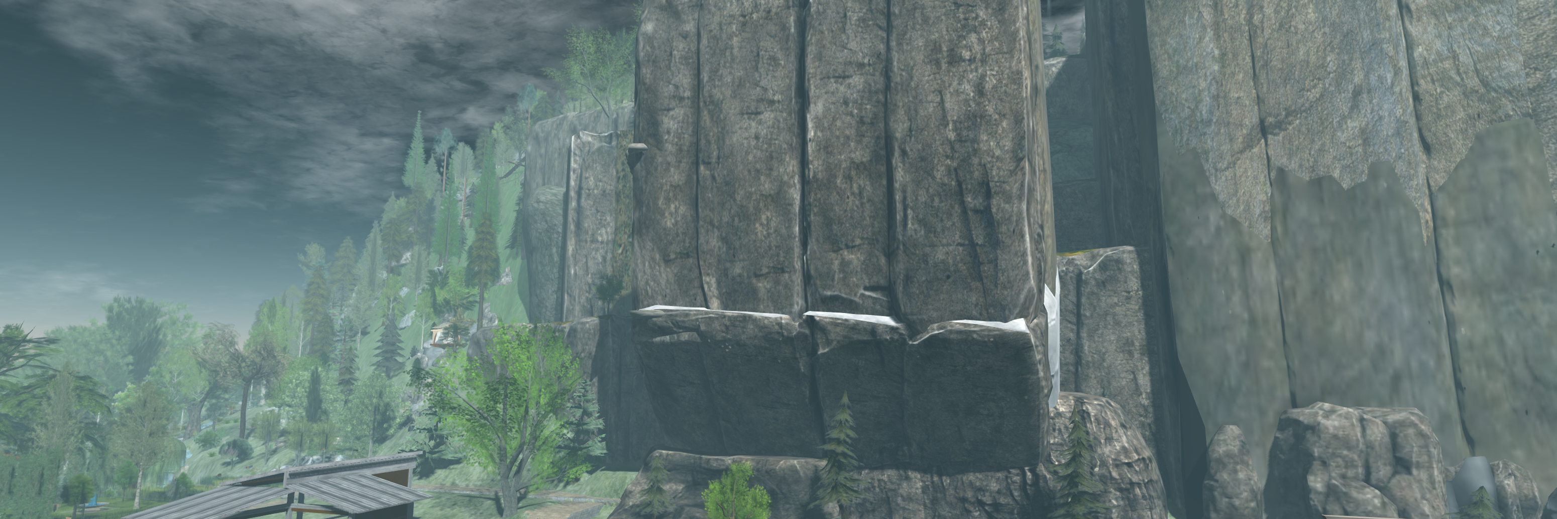
After the first 15 metre climb to a very broad ledge, you’ll have a choice: the direct route, or along the “bivvy” (bivouac) route. The latter is the more challenging, and requires you channel your inner Tom Cruise (Mission Impossible 2) for some diagonal climbing across the rock face to reach various ledges – including one with the tent, allowing you a little respite from the exertions of climbing – and additional vertical ascents.

Abseiling down the Nitida Ridge (note ropes added in post-processing so I don’t look like I’m simply sitting in mid-air!

The direct route is just that – straight up the cliff, using a natural fold in the rock, just as a real climber would. I admit to having a little trouble at the top of this – the climb animation refused to release, so I’d reach the top, fall back a couple of metres and resume climbing, reach the top, fall back… A double-click TP resolved this.

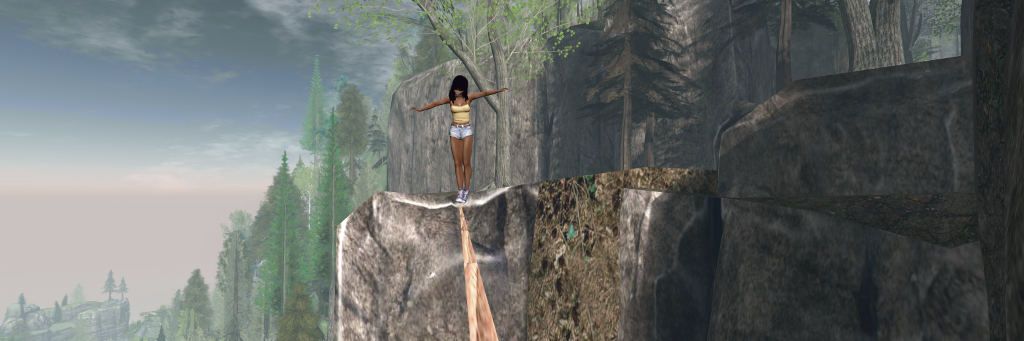
For those prone to a little daring-do, the Nitida Ridge climbs also include a couple of high lines (shown in blue on the climb image), where a little tightrope walking can be, um, enjoyed, using Yasmin’s tightrope kit.

Of course, getting up a climb is half the story – there is also getting back down. For this, Yasmin has included abseil options. Just find the anchor points located at various places on the cliff face (again, use the supplied image to help in locating them). Each is a square metal plate fixed to the rock with a carabiner hanging from it. Touch the carabiner and you’ll abseil neatly down the rock face.

Ropes for abseiling are invisible (a particle system would likely complicate matters), but the animations are fun to watch, and in keeping with climbing (I assume at least, not being an expert in any way whatsoever!) the shorter descents are more hand-over-hand.

This system is  – as noted – still somewhat in development, but it is simple and clean – and works. Obviously, you can add to the feel of climbing by dressing appropriately if you wish – I was tempted to add either a rucksack as a climbing backpack, or at least a bum bag to double as a chalk bag, but in the end just opted to get on with it.

Yasmin offers a number of alternate possible climbs within the HUD instructions note card, but as the HUD appears to be temp attach, you’ll need to keep it in place in order to try them, or return to Nitida Ridge to affix a new one before visiting an alternate climb. Overall, however, the Nitida Ridge climb is the most well-rounded in terms of climbs and features.

High lines offer the opportunity for some tightrope walking …

You still wouldn’t get me hanging off the side of a cliff at the end of a length of rope in the physical world, but within Second Life, free climbing / rock climbing like this is fun, and Yasmin has put together an excellent package that can be enjoyed individually or with friends. The kit isn’t (yet?) commercially available as it is in development (a further reason to try it at Nitida Ridge!), but I would suggest that if / when it is made commercially available, anyone with reasonable cliffs and highlands (say 15m or greater), it could be an attractive addition as an activity.

SLurl Details

The scenic glory of Athenaeum in Second Life

Athenauem, July 2019

It’s been almost a year since we first visited Athenaeum, the full region designed by Dema Fairport. At the time I noted the Adult-rated region to be stunningly scenic and offering a lot to see. For details of that first visit, see: Athenaeum: scenic beauty with an adult twist in Second Life.

More recently, Dema passed an invite for us to make a return visit following something of a re-design, I added it to the list of our upcoming destinations, and recently had the opportunity to drop in.

Athenaeum, July 2019

I’ll be honest, given the outstanding look and feel of Athenaeum a year ago, I was a little hesitant in thinking about what might have changed. The build we witnessed back in August 2018 was so visually stunning that there was a concern that any change might come at the cost of something very special being lost.

However, all such fears proved groundless; the “new” Athenaeum offers a well-rounded mix of new locations sitting within a setting that retains all of its scenic beauty and many of its popular locations. These include the the manor house to the south and the gorge that must be spanned to reach it. Thus Athenaeum presents a setting that is both familiar and new.

Athenaeum, July 2019

Chief among the changes is the landing point. This has moved from inland to the west of the region to sit on a waterfront pier. it offers the way to a surfaced road running past the gallery and museum, each of which still offers a celebration of the physical world photography of New York’s Darque, and a history of kink respectively.

From here the road climbs upwards, becoming a familiar (for those who have visited in the past) cinder track that offers the way to (again for visitors making a return to the region) a familiar bridge spanning the gorge to reach the the big manor house. The latter further retains its marvellous member’s club look and feel from August 2018, which I described thus:

Within its rooms are leather arm chairs, great bookcases filled with tomes awaiting reading, fires in the hearths, bottles of port and cigar humidors on some tables, coffee and After Eight mints on others, and just the most subtle of hints as to some of the activities that might follow conversations in these rooms; activities which themselves might be enjoined in the rooms above, going by their décor.

Athenaeum, July 2019

The manor house retains its terrace and pool where events can be held, while to the east, a path leads the way into the deeper shade of tall fir trees, to where the summer house and its pool still reside.

The newer touches to the region are subtle. Take, for example, the barn with horses roaming before it, additional cliff-top hideaways, or the rickety bridge crossing the deep gorge to offer a path to where Buddha still sits, going by way of a shaded snuggle spot.

Athenaeum, July 2019

And While it might be a case of mis-remembering over the course of the year, there also seem to be a lot more – and individually – attractive spots around the coastline for sitting and enjoying company, whether intimate or friendly. These include waterside camps with little fires blazing, covered seats mounted on rocky outcrops or wooden decks built out over the water. Cinder paths lit by lanterns and occasionally marked by vintage cars, point the way to most of them – although some may require a little discovery.

Throughout all of this, Athenaeum remains richly photographic, and the invitation for visitors to submit their images to the region’s Flickr pool remains open. If you’ve not visited before, I cannot recommend doing to enough – and if you have visited in the past but haven’t been recently, then a re-visit is also recommended.

Athenaeum, July 2019

SLurl Details

A return to Natural Falls in Second Life

Natural Falls, July 2019

Update: It appears this iteration of Natural Falls has closed. SLurls have therefore been removed.

DannChris might be a hamster in Second Life (and love the Maverick profile photo, Dann!), but he’s a hamster with a love of water settings. we discovered this when visiting his Natural Falls V in early 2017 (see Navigating Natural Falls in Second Life) and again with a visit to A L T I T U D E earlier in 2019 (see Gaining a little A L T I T U D E in Second Life).

At the start of July 2019, Dann dropped me a note thanking me for writing about A L T I T U D E which was nice in itself – and to inform me that a new Natural Falls would be coming along soon. More recently, friend and fellow traveller, Miro Collas poked me to let me know it had arrived. So hoping it has retained the watery themes present in the previous builds and within A L T I T U D E, we jumped over to take a look.

Natural Falls, July 2019

Natural Falls has tended to represent, in Dann’s words, a decaying city waterlogged by some disaster – whether man-made or natural or a combination of both (such as humanity’s willingness to acknowledge climate change but stubborn refusal to adequately address it), is up to the visitor to determine.

As with previous builds, the city sits at least knee-deep in water and under the cement conduits of a really elevated railway, the parallel tracks of which sit to the north and south, bracketing the larger part of the city below them.

Natural Falls, July 2019

Getting around is a matter of following the wooden board walks, some of which sit between walls cunningly designed to resemble buildings, adding to the feel that this is a sprawling, flooded metropolis when seen from lower levels.  Power lines are strung along some of this walkways, passing between tall poles that march along the board walks, giving the impression some of the buildings here are still occupied. The walkways don’t however, all interconnect – so if you’re going to explore everywhere (and you should), you’re going to have to be prepared to do a little jumping and / or get your legs wet.

This is particularly true if you want to get down to the little Japanese style market that sits just over (and on) the water, or drop in to the old amusement park the water has claimed as its own, the old roller coaster looking rather forlorn. A slightly worrying aspect of stepping down into the water is the fact that off to the north-east, a couple of massive electrical pylons drip their high-tension power lines in to the waves. Fortunately, neither one is actually connected to a electrical generation system, so there’s no risk of electrocution present with them!

Natural Falls, July 2019

Which is just as well, really, because it is only by wading through the water that you can get to visit what I personally think is one of the most gorgeous motifs Dann presents in his region designs: a fabulous walled and flooded garden. I first saw this in Natural Falls V, and it was  – for a time, and in an expanding form – a feature of A L T I T U D E, so encountering it within this iteration of Natural Falls came as an absolute delight.

“I had to recreate it,” Dann informed me when I noted its presence,  “We had a party at Altitude which needed a special place, but there wasn’t enough LI, so the garden got taken down.” He paused a moment and continued, “I will put it back at some point 🙂 .” If he does, I hope he actually reproduces the garden in some form at A L T I T U D E rather than moving it from Natural Falls, as it makes for an ideal focal point; and with a suitable teleport portal, could even make for a nice link between the two regions.

Natural Falls, July 2019

There are other reminders of past builds to be found here – the old pavilion sitting among the lilies, the great engines slung beneath the elevated railway lines and concrete channel that turn massive propellers – presumably helping to keep the structures aloft.

Also to be found are the more artistic / whimsical statements those who have visited past Natural Falls might find familiar. The figures close to the landing point, for the example, who stand beneath a pained warning: Who Watches The Watchers, even as a haphazard pile of televisions rises close by to apparently keep an eye on them – and while a flying saucer overhead appears to be spiriting some of them away! Then there are the quirky little places to sit waiting to be found, such as atop a set of diving boards, complete with a potted plant. Or, in a touch of delightful and fantastical whimsy, a blue whale slowly circling in the air and offering passers-by a ride, either hanging from the ladder that dangles from his flank or in the garden sprouting  from his back.

Natural Falls, July 2019

Imaginative, rich in detail, quirky, fun, and giving a little tap on the shoulder of ecological conscience, with this iteration, Natural Fall remains a thoroughly recommended visit. Photos can be shared via the region’s Flickr group.

A Lost Lagoon in Second Life

Lost Lagoon, July 2019. Click any image for full size

Lost Lagoon is a Homestead region designed by knight676 and Jana Guyot that offers an engaging – if curiously populated – setting that also has the ability to look and feel much bigger than the  65,536 sq metres offered by a region.

The region description states Lost Lagoon is a “lost place in the South Seas. Witnesses of bygone days and paradise for those who seek solitude and nature.” Certainly, it has all the elements one might associate with the South Seas (which usually encompasses the South Pacific): a tropical feel, palm trees, balmy beaches, and so on. But there is enough here to throw something of a spanner in the idea that Lost Lagoon is a South Pacific paradise and which serve to make it a unique setting deserving of exploration.

Lost Lagoon, July 2019

Surrounded by off-sim islands that perhaps in places look a little more temperate with there grass slopes, this is nevertheless a tropical setting, as evidenced by the presence of both palm trees and Moai, the latter of which certainly give the region a Polynesian twist. The island itself offers every sign of having once been the home of a lagoon: to the south is what appears to have once been a rock wall, long since breached by the sea, causing the former lagoon to become a bay cutting deeply into the island.

Within this bay are two much smaller islands,  little more than sandy humps. However, one of them is home to a small group of African elephants – the first hint, perhaps, that this really is a lost and unusual setting. They sit under the palm trees and even wade in the water, apparently unfazed that it is most likely salty seawater.

Lost Lagoon, July 2019

Of course, one might argue that the presence of African elephants might be excused by the fact that Asian elephants are in short supply in SL – but what then of the hippos with their slightly oversized tusks occupying the water by the second of the two little islands? They perhaps more directly throw a suggestion of Africa into the mix, contrasting strongly with the south seas idea, while the tigers roaming the island behind them further stirring the mix.

Thus, Lost Lagoon offers an intriguing mix, almost is if it is a kind of lost world in terms of the creatures to be found across it. And nor are the elephant, hippos and tiger the only curious mixing. Lions and meerkats also offer further hints of Africa – although the latter might be standing-in for mongoose. Also to be found across the island are snakes, waterfowl and birds of assorted kinds, all presenting  rich mix of wildlife.

Lost Lagoon, July 2019

There is also considerable evidence of human habitation to be found here, both ancient and modern. The latter perhaps most clearly comes in the form of the great, dome-topped finger of a lighthouse to the east of the island. Beneath it and almost within its lee, sits a nicely furnished cabin – perhaps that of those responsible for maintaining the lighthouse – built out of the cooling waters of a shallow bay.

Ruins to be found in the bay offer a more ancient setting, while the sometimes ramshackle cabins found around the coast help to give the impression that humans have been living here for some time. However, perhaps the most curious mad-made structure on the island is that of an aged submarine that appears to have grounded itself on part of the ancient lagoon wall. It had clearly been there so long that it has be claimed by the local foliage to the point where, from the landward side of the island, it looks like a metallic cavern sitting at the end of the trestle bridge that reaches out to it.

Lost Lagoon, July 2019

These low-lying man-made structures and ruins are overlooked by a old fortification and small chapel both of which stand on the island’s rocky spine. They are reached via a twisting path offering more chances for exploration, while on their far side, sitting on its own promontory and reach by passing under a rocky arch, sits the most wonderful ruin of a church or cathedral, beautifully repurposed.

With its rich mix of wildlife and range of influences – Moai, a Moroccan water pump house, a sitting Buddha, shrine to Shiva, and so on – Lost Lagoon really is an intriguing mix wrapped in an attractive tropical setting. There is a lot of take in, plenty to photograph (with a Flickr group for those who might was to share their images, rezzing rights available by joining the local group for L$150), and numerous places to simply sit and appreciate the location.

Lost lagoon, July 2019

SLurl Details

The beaches of Carolina in Second Life

Carolina, July 2019 – click any image full size

Warm sandy shores and tropical environs welcome you in this land filled with wildlife, relaxing beaches, and grassy areas. I hope you enjoy your stay and please remember to pick up after yourselves when you go.

– Arol Lightfoot, describing Carolina

Carolina, July 2019

Region designs by Arol Lightfoot are always guaranteed to generate a lot of interest, and so it is with her latest Homestead design, Carolina.

As Arol’s description of the region indicates, this is a very rural, open island setting. Three houses sit within its sandy banks and beaches, two on the coast and the third a little more inland. They sit amidst circling birds while Flamingos strut over the more grassy aspects of the island and horses stroll under the haze-heavy sky.

Carolina, July 2019

The surrounding waters cut into the island to form bays and channels, giving the low-lying land a richly natural look, grass and sandy mingling easily, waterfowl sitting among the piers and rocks that help define the landscape. A curious mix of trees – oaks, palms and Lebanon cedar – rise above smaller trees with bent trunks as if bowed under the weight of their boughs and leaves, but together they help further define the island’s look.

This is a genteel landscape where cats mix easily with dogs, donkeys and goats, all of whom add their own personalities to the region – some quite cheekily so. The only oddity within the setting is the battered and ageing humps of an old roller coaster. It’s not the kind of ride you’d want to take, given the state of the rail-less tracks, despite the cars being present – but it does made an interesting focal-point for photography.

Carolina, July 2019

Photography is very much a raison d’etre for Carolina, again as the About Land description notes. Rezzing in the region is open, but as auto-return is turned off, those who take advantage of it are asked to remember to pick their items when they are finished.

Peaceful, with multiple places to sit and relax and with its wildlife rounded-out by the presence of otters, sea lions – and pandas, Carolina makes for a quiet visit for those so minded, a cosy island with opportunities to explore, to sit and to contemplate – just mind the sharks if you go for a swim!

Carolina, July 2019

SLurl Details

  • Carolina (Margarita Isel, rated Moderate)

Of flying saucers and alien encounters in Second Life


Cornhub, July 2019 (click any image for full size

Cornhub is a rather curious region, one which apparently changes perhaps more regularly than other public regions (designer Mya Milena notes of the region, “we change themes like socks”!). At the time of writing this piece, it offers a look into one aspect of modern-day mythology: that of flying saucers and alien visitations.

We were dawn to the region after seeing Ricco Saenz’s pictures of Cornhub on Twitter (and you can read about his explorations here). But if I’m honest, they didn’t entirely prepare us for what we found: this iteration of Cornhub is quirky, unexpected, different and, well, strange, with the flying saucers just a part of the story. However, it is the one I’ll start with, as it is perhaps the most obvious.

Cornhub, July 2019

Sitting in the midst of this desert landscape is a crater out of which rises the crashed hull of a flying saucer, bodies of “greys” lying on the cracked ground where they were either thrown during impact or staggered to on escaping before collapsing. A second flying saucer is circling above, wobbling in its flight in the way such vehicles tend to do in those old 50s sci-fi B-movies.

A sign by the roadside that passes the crash site points the way to the “UFO Crash Site Roswell, New Mexico”. So, whether this crash is intended to represent that so-called incident is debatable. Certainly, other signs in the area suggest this is might actually be the legendary (in alien conspiracy theory circles) “Area 51” (officially, the  Homey Airport or Groom Lake in the middle of the Nevada Test and Training Range) – which is roughly 900 miles from Roswell.

Cornhub, July 2019

For those perhaps unfamiliar with the Roswell incident of mid-1947, it was triggered when a special high-altitude balloon being used by the (then) US Army Air Force in a top-secret endeavour came down some 75 miles from the town of Roswell. That secret endeavour was Project Mogul, an attempt to detect the sound waves generated by Soviet atomic bomb tests using special equipment suspended from high-altitude balloons.

Due to the sensitive nature of Project Mogul, various official statements were made about the nature of the crash were contradictory or simply didn’t match the facts (one USAAF report referred to the crash being a “weather balloon”, although the Project Mogul balloons were very different beasts). The event occurred just two weeks after aviator Kenneth Arnold made his famous report of seeing nine “saucer-like” flying objects near Mount Rainier, Washington State, so when a report was issued that a “disc” (albeit one apparently small enough to be held in the hands) had been recovered at the crash site, the press briefly went wild with speculation – something which, 30 years after the fact, resulted in Roswell becoming infamous as an alleged “UFO crash site”.

Cornhub, July 2019

Whether you chose to see the Cornhub flying saucer crash as being a play on the so-called Roswell UFO incident is up to you. For my part, I found myself leaning more towards the road sign with its arrow being more a passing reference to Roswell, and the setting within the region far more of a play on the whole mystique of “Area 51” and its place in both “UFO / Alien visitation” mythology and some science fiction films.

There are certainly enough clues for the latter being the case: the Area 51 signs, the military vehicles parked close by, and the spacesuited figures of humans also scattered about the crash site. The latter in particular take on more of a sci-fi meme: the suits carry the NASA logo and look to be modelled on modern US EVA spacesuits. However, they also appear to have been ineffective in projecting those wearing them from something undoubtedly nasty in the immediate vicinity of the crash.

Cornhub, July 2019

North of the crash site is what might be the edge of a town, one which might be taken as Roswell if one goes in that direction, or perhaps some little hamlet on the edge of the Nevada Test and Training Range. It offers a curious mix of buildings: there’s a very 50’s style diner and drive-in diner sitting alongside an 80s video game arcade, while SL table-top games can be found in the parking lot. Meanwhile, just across the road, there’s a concrete tower block that might at first appear to be a military-style structure (and thus suggestive again of “Area 51”), but which is in fact an apartment building, a trailer park (travelling UFOlogists?) located in the car park at its base.

Elsewhere, back towards the middle of the region, sitting between the flying saucer crash site and the region’s landing point, the top of the Statue of Liberty’s head rises from the dried sands, almost in a nod to the Planet of the Apes franchise and adding a further twist to the setting. Meanwhile, and off to the south where it stands alone, is the warehouse-like bulk of a television recording studio, apparently the home of “Cornhub’s Blind Date”.

Cornhub, July 2019

Eclectic, unusual, overlooked by a Hollywood-echoing hillside sign spelling out the region’s name, and with a pot-pourri of ideas, Cornhub in this current iteration makes for an undoubtedly a strange – but also curiously photogenic. But remember, it might not be around too long, so should you want to visit, it might be best to do so sooner rather than later!

SLurl Details

  • Cornhub (North Korea, rated Moderate)