An oriental Les Reves Perdus in Second Life

Les Reves Perdus; Inara Pey, January 2018, on Flickr Les Reves Perdus – click on any image for full size

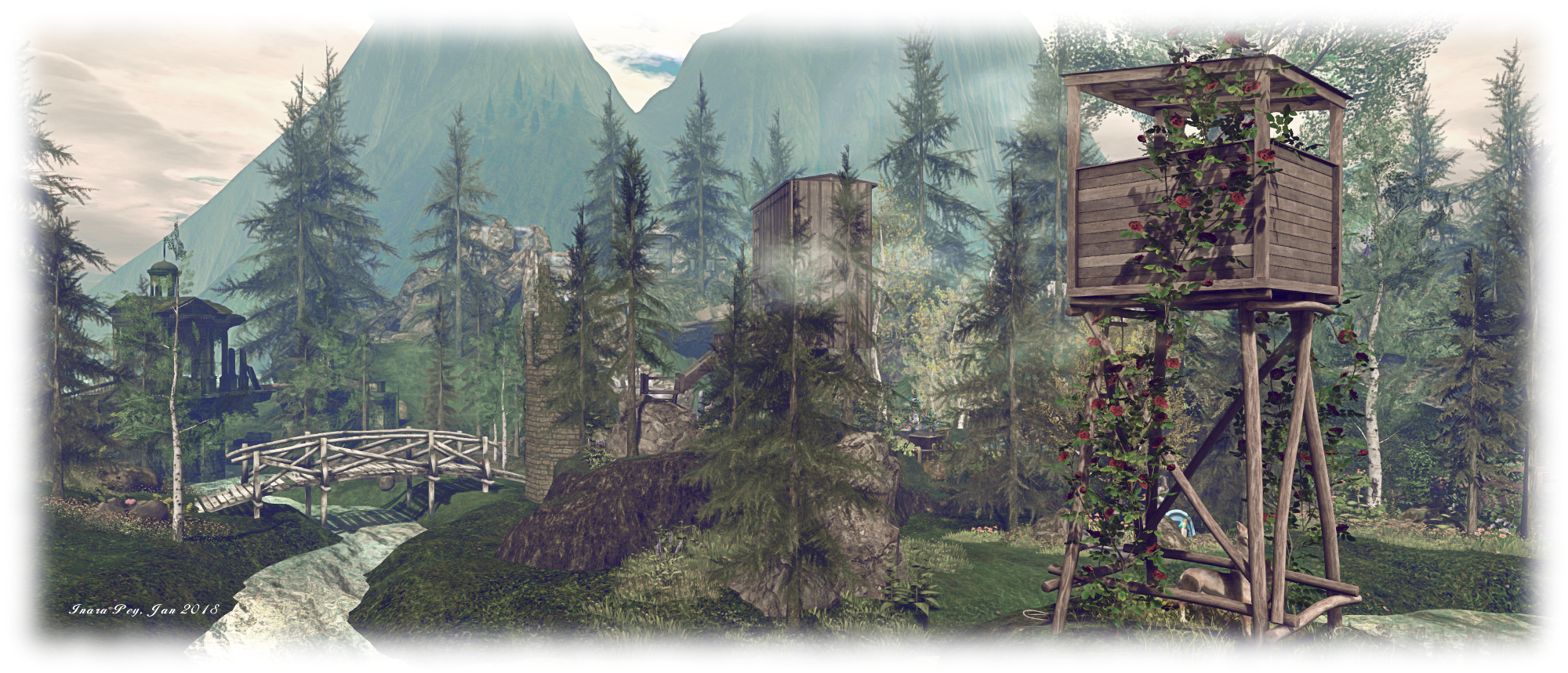
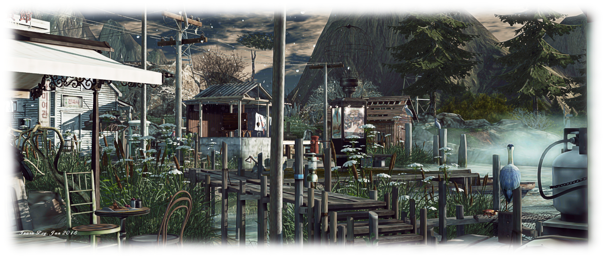
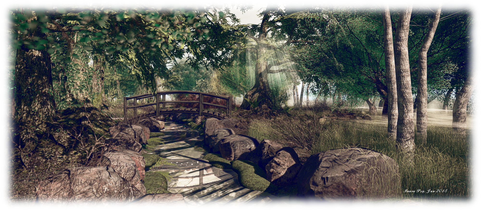
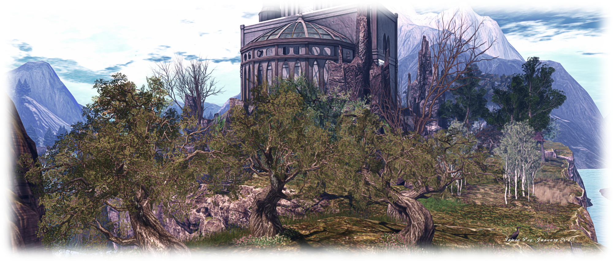
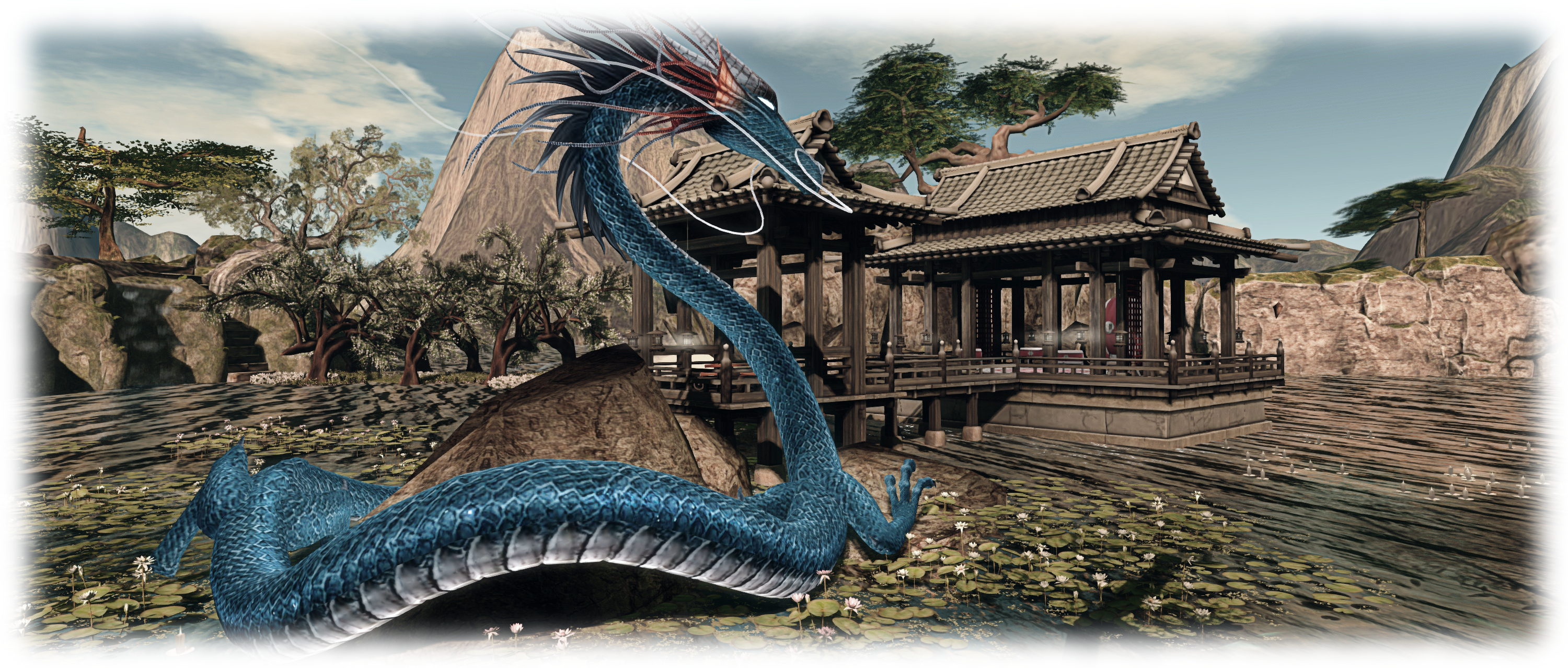
Miro Collas drew my attention to Les Reves Perdus (“Dreams Lost”). It’s a place we’ve enjoyed visiting in the past and which I’ve previously written about here and here, so we were more that happy to make a return visit. Designed by Cathy (zaziaa), she relocated to a new Homestead region in November 2017, and with the move offers a design with a distinctly oriental flavour that also encompasses a nice use of water.

Visitors arrive before a memorial gate, lit by floating lanterns. A trail of firefly-like lights float just above the water, leading the way to the largest of three islands in the region, which rise from the water on sheer cliffs to form a table-like top. Water tumbles from a series of falls on the west side of the island, alongside a set of stone steps rising from the water to provide a way to the top.

Les Reves Perdus; Inara Pey, January 2018, on Flickr Les Reves Perdus

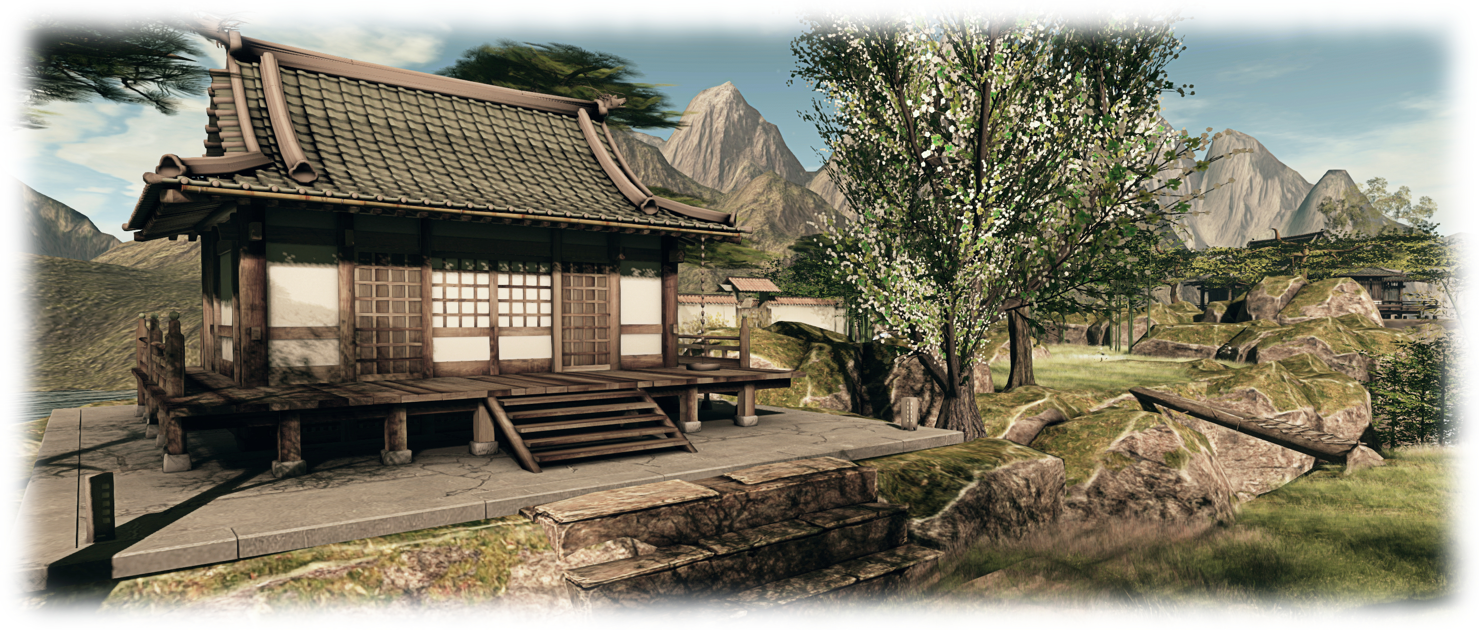
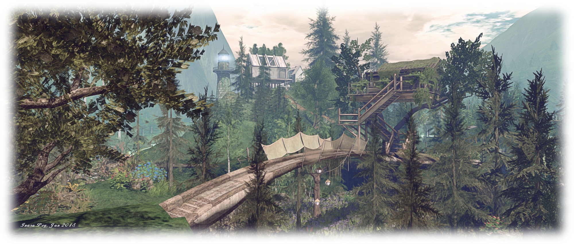
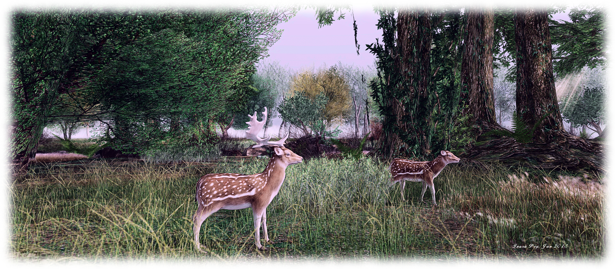
A small temple sits on the island, a formal walled garden beyond it, reach by a couple of bridges that span two small channels cutting into the rock. While the garden and temple have a distinct Japanese look to them, there is bamboo growing alongside the wall of the garden which has attracted an embarrassment of pandas, giving the setting a Chinese flavour. More waterfalls tumble from the north side of the island, while around the cliffs can be found rock carvings, a Buddha and floating candles, all of which add subtle touches to the setting.

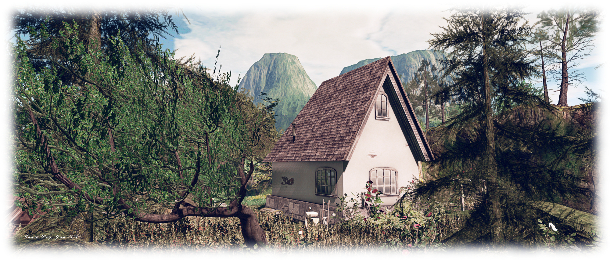
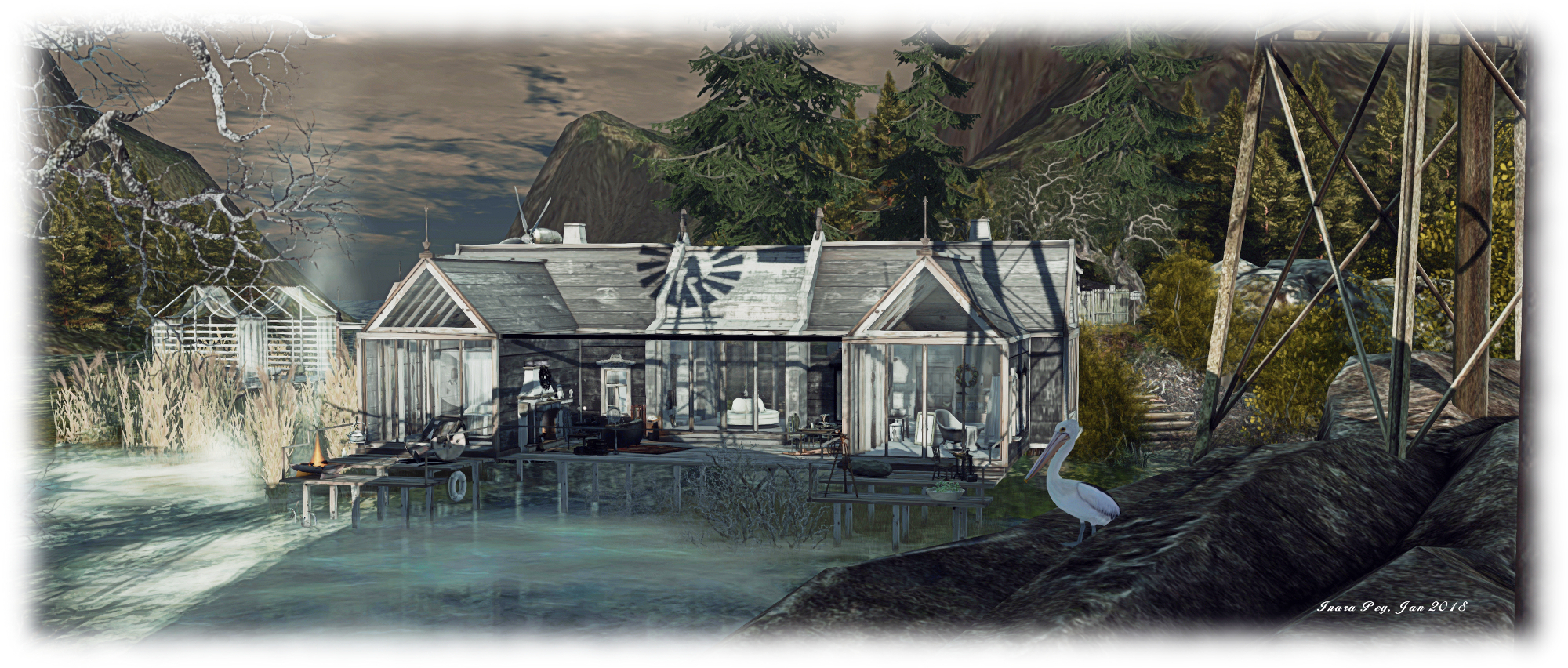
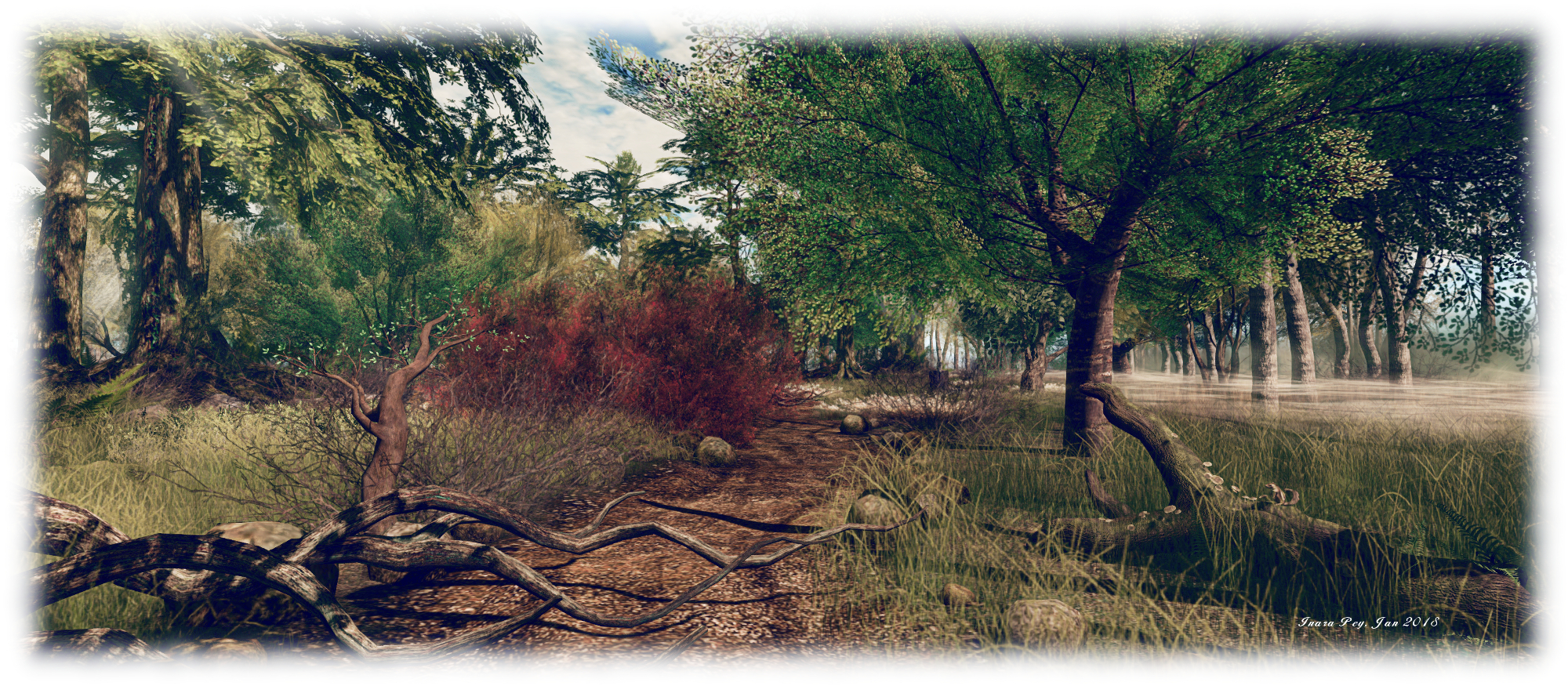
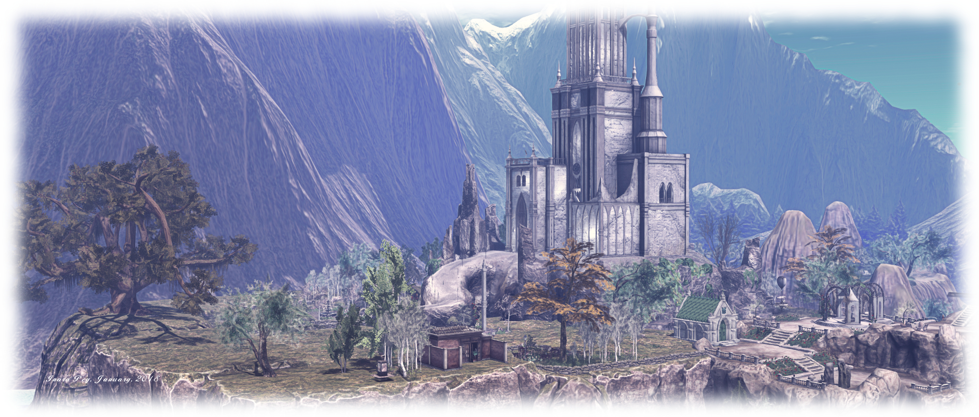
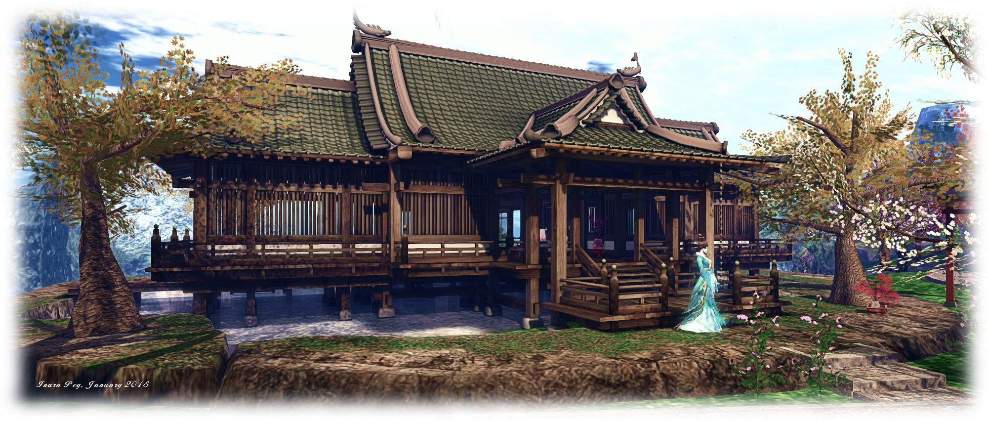
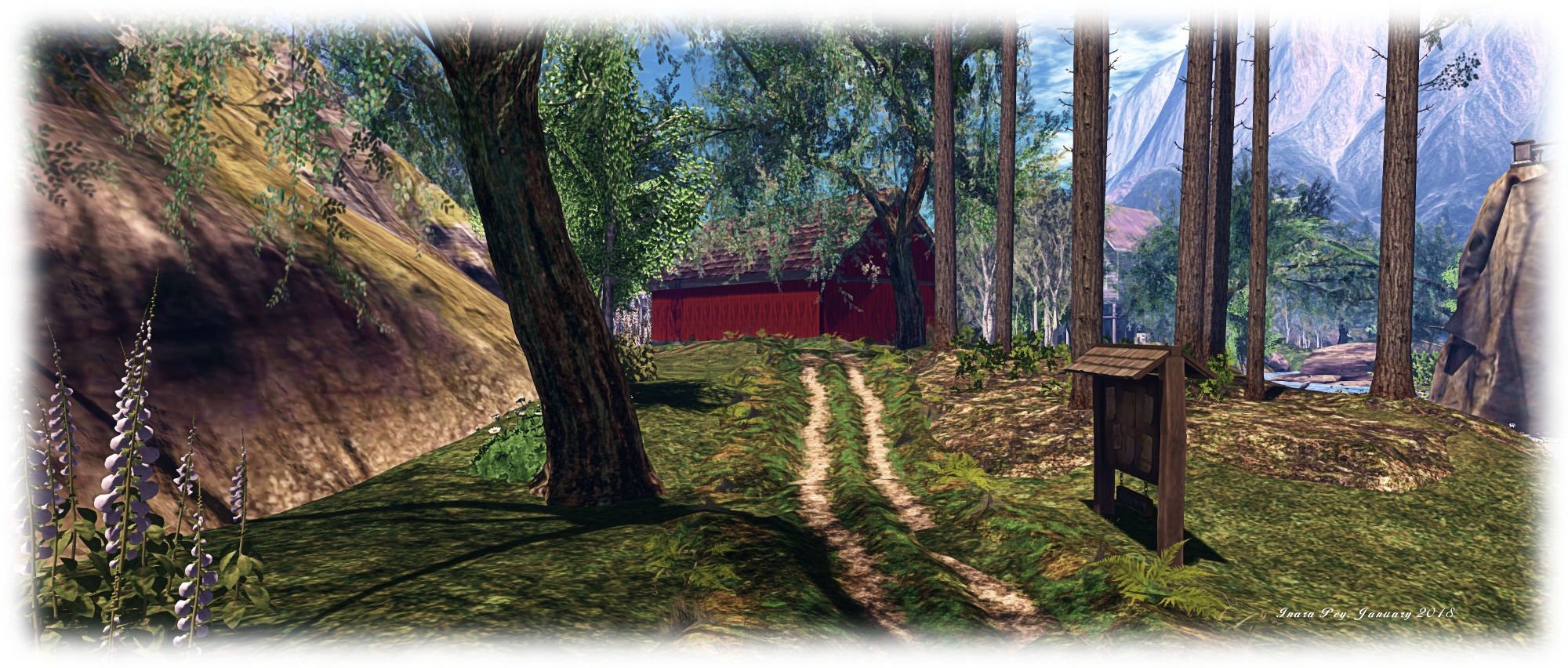
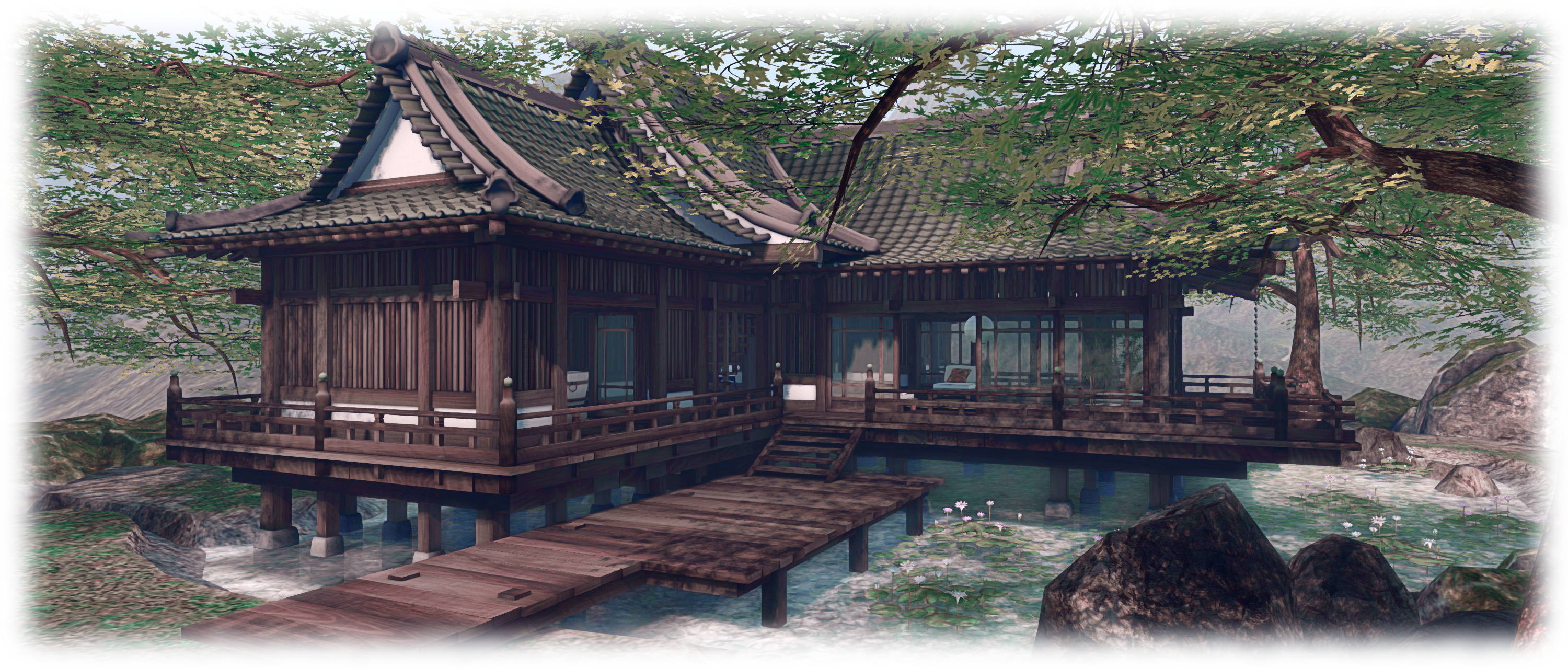
To the south-east of this large island is a second. Again flat-topped and with sheer cliffs, it is home a large Japanese-style house, sitting over a body of water which doesn’t quite feed the falls tumbling from the rocks – at least, not on the surface. The steps leading up to the house also link it with an avenue of trees running to the beach at the base of the region’s third island. Follow this and you’ll find an ancient pier pointing out to sea, facing a path winding up the side of the island’s cliffs, with the entrance to a cavern at its base.

Les Reves Perdus; Inara Pey, January 2018, on Flickr Les Reves Perdus

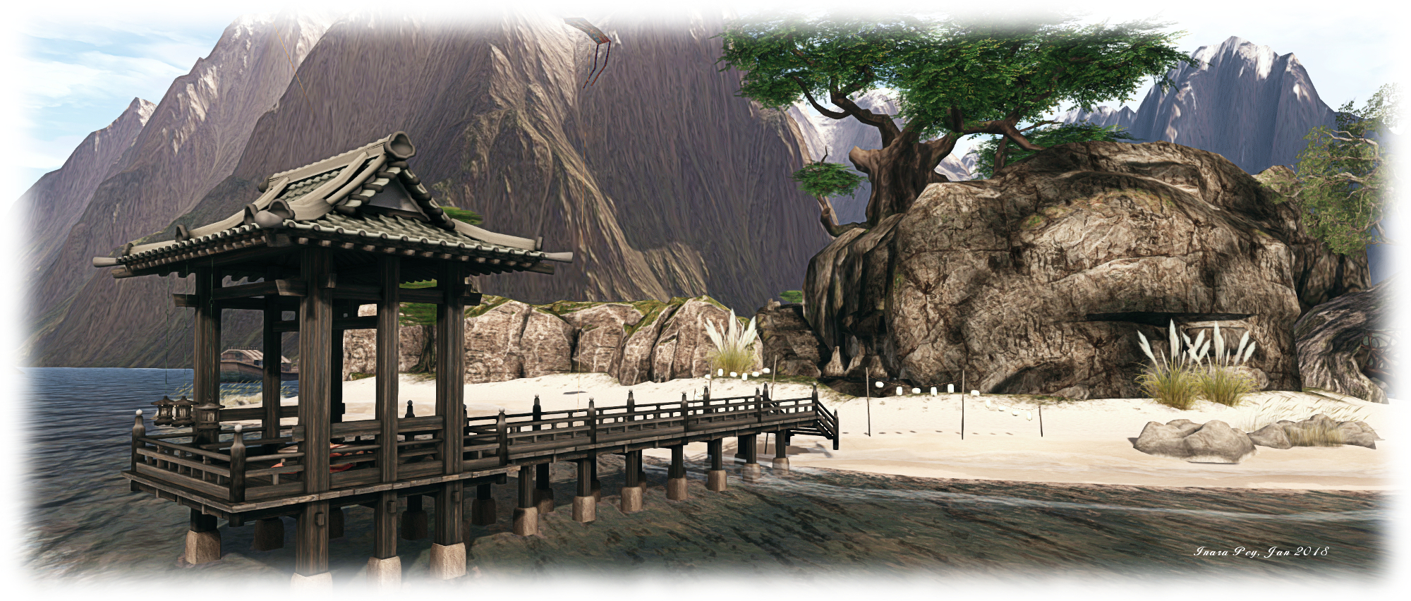
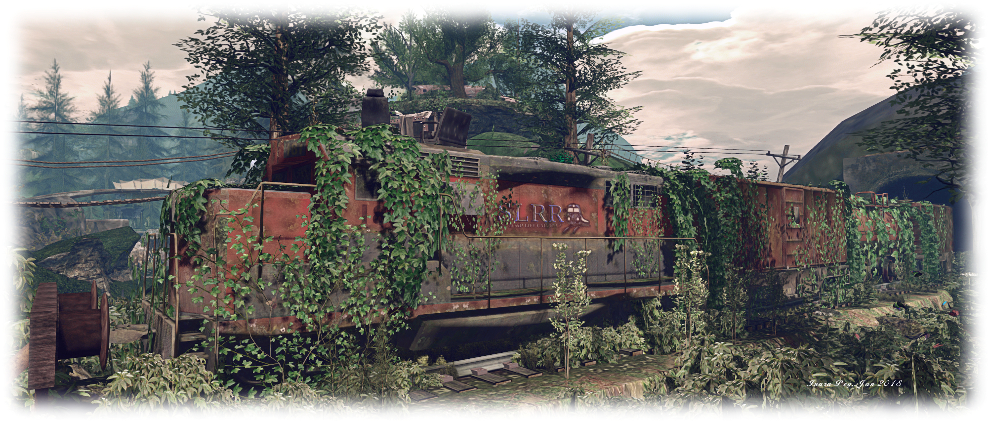
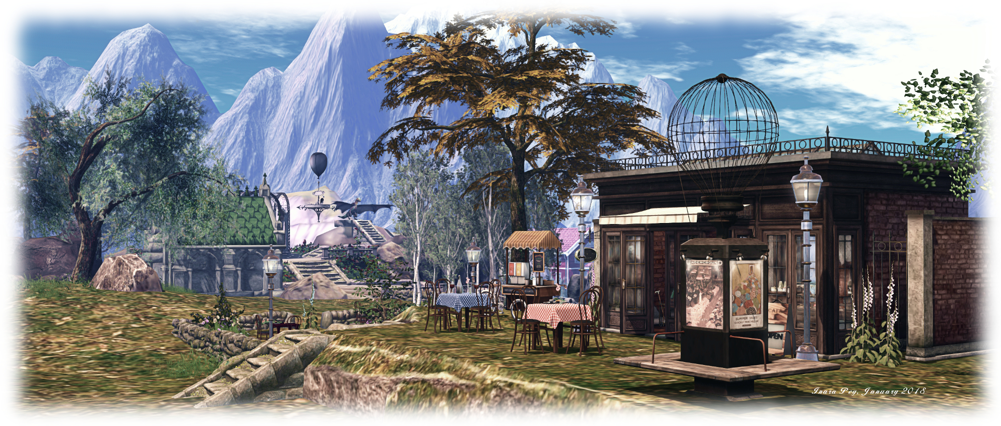
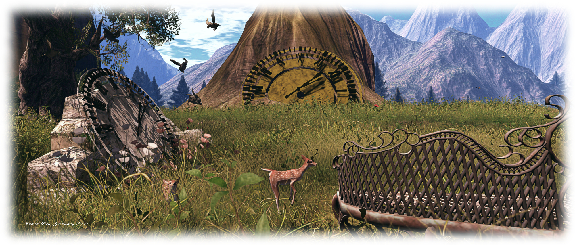
All of this just scratches the surface of the region’s beauty. Near to the arrival gate is pavilion where Chinese drums and Zheng can be played, all under the watchful eyes of a dragon. Candles float over the water alongside the pavilion, while plants hug the waters at the base of the islands. as well as the drums and Zheng, the pavilion offers the opportunity to enjoy Tai Chi, while the house on the “middle” of the three islands offers a place to relax and simply enjoy the setting. There are a couple of adult elements in the caverns under one of the islands – but there are not anything that should give offence.

One of the delights in visiting Les Reves Perdus is that each iteration is entirely difference to the previous, making every visit after a redesign both a pleasure and an opportunity for discovery. This latest build is no exception; it is wonderfully tranquil, with a subtle sound scape and, for those so minds, a reflective audio stream courtesy of  Chouchou.

Les Reves Perdus; Inara Pey, January 2018, on Flickr Les Reves Perdus

As someone who delights in oriental themes and a considered use of water in a region build, I  admit to thoroughly enjoying reacquainting myself with Les Reves Perdux in its new home, as did Caitlyn. We both look forward to future visits.

SLurl Details

Flying Coyote River in Second Life

Flying Coyote River; Inara Pey, January 2018, on Flickr Flying Coyote River – click on any image for full size

Miro Collas passed on a suggestion we pay a visit to Flying Coyote River, a Full region designed by Lila Rose (Masha Eilde) and open to people with Payment Information On File (PIOF). It’s a strangely eclectic wilderness region with plenty to see, and which can be very photogenic under a wide variety of windlight settings.

The landing point sits in the middle of the region on a small island, the rest of the land divided into four, each part ruggedly terraformed using a mix of the natural terrain and mesh elements. Precisely where you go from the landing point is entirely a matter of personal choice. Before doing so, and if you want to get a feel for the immediate surroundings, there’s a small watchtower offering a vantage point for a look around (you might also want to see what is under the little hillock of the island).

Flying Coyote River; Inara Pey, January 2018, on Flickr Flying Coyote River

However, whichever route you choose, you’ll be setting off on a voyage of discovery, because there is an awful lot to be found right across the region. So much so, in fact, that attempting to describe everything here would lead to a long article and spoil the fun. However, were I to be asked to define a possible single-word theme for the region, then it might be in “community”.

Not that there is an actual community of users here per se, but rather that the region has been designed to give a feeling that it has been established by a group of people; although quite why they’ve done so here in the wilds surrounded by mountains, is a story perhaps best left to individual imaginations. It’s also the kind of place that looks ripe for casual role-play for like minds paying in a visit – and that’s something that visitors are invited to try, as noted in the About Land description.

Flying Coyote River; Inara Pey, January 2018, on Flickr Flying Coyote River

Buildings here come in all forms: houses, tree houses, converted rail cars, cottages, lighthouses, towers – even caves and hollows. All are scattered across the landscape, atop hills, improbably perched on cliffs, nestled along the coast or sitting in the branches of trees. Linking them one to the next is a series of trails, paths, bridges, ladders, tunnels and stairways, some of which are quite imaginatively placed, with others offering more than one way to reach a destination.

The best way of exploring the region is not to flycam / cam ahead – at least not to start with. It is far more fun to follow the paths and climb the hills to see what lies beyond the next ridge or hilltop then it is to constantly cam ahead. This way, you really get the feeling of being out in the wilds; and such is the design of the region, it can quickly start to feel as if is it far larger than its 256 metres on a side. Just as you feel you must have seen everything, there is something the pops into view or is at least hinted at just over the next rise – and so you’re drawn onwards.

Flying Coyote River; Inara Pey, January 2018, on Flickr Flying Coyote River

In this way, places like the garden with its wrecks of cars and bursts of flowery colour amidst the greenery of hills and trees raises a smile far more than when simply camming to it, while it hint of what might be a cavern or tunnel entices you further around the base of a hill or over a bridge and up a gravel path.  Gentle exploration also brings out the very mixed aspects of the region’s design, which brings together something of a post-apocalyptic flavour with twists of fantasy, all stirred into the feeling of being in the great outdoors – including a rope slide for the adventurous.

It is true that elements of the design are a little rough here and there – platform legs not quite reaching the ground, footings of bridges and buildings perhaps not as firmly placed into ledges and cliffs as they might be. But really, this doesn’t matter: Flying Coyote River offers so much to see, the attractions more than outweigh the niggles. There are also plenty of places to sit and rest, or look out over the landscape, from both indoors and from outside, again making a visit more than worthwhile.

Flying Coyote River; Inara Pey, January 2018, on Flickr Flying Coyote River

Again, when visiting the region, please remember access is restricted to those with PIOF, and note also that scripts are disabled if you re-log directly to the region. Our thanks again to Milo for suggesting we take a look.

SLurl Details

Neverfar in Second Life

Neverfar; Inara Pey, January 2018, on FlickrNeverfar – click on any image for full size

“A little piece of my heart and soul I created for this world to enjoy some quiet time and create moments,” inertia (Caridee Sparta) says of her Homestead region of Neverfar, which I came across recently while poking my nose into the Destination Guide. It is an atmospheric and eclectic place to visit, offering  a good amount to see and discover.

A good part of the region is formed by a rugged island rising from calm waters, its top stony and hard, a place where shrubs and old trees with deep roots claw for purchase. A small village sits on its hard back, a place with a strong oriental theme among its buildings – something which is always bound to attract me. While mixed in nature, with something of a lean towards Japanese influences, I found this little village put me in mind of secluded places along the south coast of China, huddling away from that country’s rapid urbanisation, or perhaps located on the Indochinese peninsula – although it might just as easily be somewhere on one of the islands of Japan.

Neverfar; Inara Pey, January 2018, on FlickrNeverfar

Surrounded by tall, evergreen mountains, and gathered around a little bay where two long fishing boats rest in the mist hugging the shoreline, the village is a mix of tall, cement-sided buildings and wooden huts and shacks, most of them with corrugated tin roofs. It has the feel of being a place of work, rather than being for vacation, so the tall face of the optimistically named Regent Hotel seems a little odd, while the neon lights illuminating a side street attempting to entice people to come and sample the local food, have an air of pathos about them, particularly considering a couple sit above shuttered entrances.

Wooden walkways offer routes around the buildings, wood being more practical given both the unforgiving rock from which the village rises and the way it extends out over the water. For example, to the north-east a small café sits on a wooden platform above the waves and reached via a narrow walkway. A second platform close by offering a place to sit warmed by an electric fire and with incense burning in a bowl in greeting while a cat enjoys the fire’s warmth.

Neverfar; Inara Pey, January 2018, on FlickrNeverfar

Behind the clustered buildings of this village are more board walks, raised over the rocks on wooden piles and reached by short stairways. They offer a view across the waters to the south, to where a smaller island sits, marked by a somewhat decrepit wooden tower at one end, and a Japanese-style house at the other. A rickety pier – or the remnants of an old bridge? – point towards this smaller island, but the only way to reach it appears to be to take to the air and join the gulls circling back and forth over the intervening water.

To the north-west is a further rocky islet, this one the location of a private residence, which is in use – so please respect privacy and avoid the temptation of trying to hop over. Facing this, on the main island, is a small music stage with a pier below it. Stage and pier are reached by crossing the rugged land to the west of the village, beyond the bicycle stands, and passing by way of an old, broken railway car now converted into something of an unusual piano lounge. Be sure to keep an eye out  for some of Cica Ghost’s animated stick figures along the path!

Neverfar; Inara Pey, January 2018, on FlickrNeverfar

Rugged and with a touch of haunting beauty under an evening’s sky, Neverfar is a welcoming place to visit. There is much to see and plenty of places scattered throughout where visitors can sit and rest.. Those wishing to have rezzing rights for photography can join the region’s group (L$499) – please do remember to pick up your bits if you do. There’s also a Flickr group for those wishing to submit their photos. Note that I do offer an alternate SLurl to that provided in the DG, as the latter (at the times of our visits at least) lands visitors atop a non-phantom tree alongside one of the broad walks.

SLurl Details

The natural beauty of Oh Deer in Second Life

Oh Deer; Inara Pey, January 2018, on Flickr Oh Deer – click on any image for full size

Update, January 25th: Oh Deer has sadly closed, and Bambi is apparently taking a leave of absence from Second Life.

We made an early return visit to Oh Deer, the Homestead region designed Bambi (NorahBrent), after receiving news from both Miro Collas and Shakespeare that the region had been given a makeover.

Our first visit to the region was made in October 2017, when we found it to be rich in autumn’s charms, offering a mix of buildings and open spaces visitors were welcome to wander in and through. Returning in mid-January 2018, we found that not only has it been redesigned, but the clock has also marched forward, the environment settings perhaps suggesting a late spring morning; a time when the sky hasn’t quite made up its mind whether or not to let the sun in all its glory, but the air is warm enough to raise a morning mist from dew and stream.

Oh Deer; Inara Pey, January 2018, on Flickr Oh Deer

In this iteration of the region, buildings are conspicuous by their absence; not a single house or shop or any other permanent structure is to be found. Instead the land, split by a meandering stream, is given over entirely to nature, rich and greens and browns, with animals, plants and birds adding their own splashes of colour.

From the landing point alongside the single bridge spanning the quiet waters of the stream, visitors are free to wander where they please. Whether this be southwards, along the meandering track pointing away from the bridge, or north over the bridge to where the same track arcs around to take its own winding route south along the far side of the stream, is entirely a matter of choice. Or, if preferred, visitors can strike off the trails, and wander through knee-high grass and between the trunks of tall trees to where the mist hugs the ground, adding an ethereal feel to the landscape.

Oh Deer; Inara Pey, January 2018, on Flickr Oh Deer

Across the land can be heard the sounds of birds, crickets and the rat-a-tat of a woodpecker busy drumming on the stump of a fallen tree.   Squirrels frolic on the ground near the landing point, while fallow deer wander under the branches of trees, their coats as dappled as the sunlight filtering through the canopy of leaves overhead. Further afield, foxes might be seen, while cormorants , osprey, turtles and bear can be found scattered along the banks of the stream as it winds through the land.

This is, in a word, a tranquil setting; a place perfect for finding a little peace and forgetting the hustles and toils of life. To encourage people to tarry a while, picnic baskets sit on benches to one side of the landing point, while a little camp site hides behind the bowl of a tree on the other. It would be nice to perhaps have a couple of places visitors might rest further out from the landing point, where the peace of nature and the playfulness of foxes or rabbits or the wandering of deer might be observed, but this is a minor point.

Oh Deer; Inara Pey, January 2018, on Flickr Oh Deer

Simple and elegant in this iteration, Oh Deer offers a charming rip into the countryside, one suited to being seen in the cool spring light in which it is set, or under the blue skies of summer – as I’ve done with some of the images here. As always, photos can be submitted to the region’s Flickr group.

SLurl Details

  • Oh Deer (Heavenly Waters, rated: Moderate)

Lost in Thor’s Land in Second Life

Thor's Land; Inara Pey, January 2018, on Flickr Thor’s Land – click on any image for full size

Land of Thor is a huge setting designed by Thor (Anaadi Resident), who recently extended an invitation for Caitlyn and I to visit. Located on a Full region, it is one of the first places we’ve visited to make use of the additional 10K Land Impact allocation available to Full private region owners who wish to raise their overall total from 20K to 30K – and the additional allocation has been put to extensive use!

“The region is very loosely based on Norse Mythology,” Thor informed me when offering the invitation, “and has a lot of interesting places to discover.” Which, as it turned out, was something of an understatement!

Thor's Land; Inara Pey, January 2018, on Flickr Thor’s Land

The land itself, bathed in sunlight under a cold-looking blue sky and surrounded by tall, rugged peaks with flanks cloaked in fir trees, certainly has a Nordic feel – on arrival I was reaching for a woolly jumper. Roughly divided into four parts by river channels, the land is a curious set of contrasts, with each part named for one of the nine realms of Norse mythology.

The main landing point sit on the largest of these four parts: a huge table of rock occupying the north-west quadrant of the region. Sitting beneath a humped shoulder of rock from which rises Asgard, legendary home to the Æsir tribe of gods. Facing south, the landing point looks out over much lower-lying lands. A switchback path curls down to these lowlands from a slightly lower shelf of rock reached via stone steps, while a great waterfall plunges from a cleft in the great plateau.

Thor's Land; Inara Pey, January 2018, on Flickr Thor’s Land

Like its namesake, Asgard is surrounded in part by a (albeit low) wall, while smooth path of smooth stone snakes up to it from the west, where sits Yggdrasil, the mythical tree that connects the nine worlds in Norse cosmology. Travel north from the tree, and then west along the cliff edge of the plateau, and you’ll come by way of a grassy trail through avenues of trees leading east, to where a great stone arch spans a deep chasm, offering visitors a way to reach Alfheim (or Álfheimr, “Land Of The Elves” or “Elfland”). This is another highland area, rich in tall grass and where time seems to have stood still, sitting among low, pointed peaks of rock.

Below these northern heights sits Midgard, home of the humans in Old Norse, and for the region, the location of a modern-looking settlement broadly split into three parts: an open-air entertainments area sitting at the foot of the high cliffs of Asgard / the main landing point and separated from the rest of the town via a narrow channel. South of this, and straddling a small natural harbour, sits the rest of the town. Many of the houses are raised on stout wooden stilts, several of them brightly coloured, and fishing boats are tied-up at wharves, marking this as a working town, rather than a holiday setting. A large house – that of the mayor? – sits slightly elevated and a little separated from the rest, occupies the south-east corner of the land, and all of the houses are open to the public.

Thor's Land; Inara Pey, January 2018, on Flickr Thor’s Land

But this is not all; sitting under the plateau of Asgard, and reached via teleporter (look for the carved stone disks located around the region) or – for those keen of eye – via a hidden entrance curtained by water – is Helheim. Traditionally the abode of Hel, daughter of Loki, in this instance it is a place of winding tunnels and chambers. Easy to find one’s way into, but perhaps not so easy to find a way back out.

Helheim is sometimes linked with Niflheim (“land of Mist or “world of the darkness”), which is one of the locations only reached via the teleport system. Like its namesake, this a place of ice and snow – and home to another great castle-like hall, this one equipped as a club.  Also accessed via the teleport system are Jotunheim (or Jötunheimr, the land of the Giants) and Svartalfheim.

Thor's Land; Inara Pey, January 2018, on Flickr Thor’s Land

For Land of Thor, Jotunheim is presented as an oriental / Japanese environment, although at least one giant is present near the landing point. Cobbled paths run through the landscape here, linking points of interest, which include an interpretation of FLW’s Fallingwater, and floating islands reached via ropes bridges, as well as a pagoda rising from a nearby peak – also reached via rope bridge.

In Norse mythology, Svartalfheim is the home of the svartálfar (“dark elves”). Here, and while dark (being underwater), it has more of a sci-fi / post-apocalyptic feel to it, with a particular emphasis on a certain sci-fi franchise. It can also be reached without teleporting – for those travelling far enough through Helheim’s tunnels.

Thor's Land; Inara Pey, January 2018, on Flickr Thor’s Land

Even with all this description, I’m still only scratching the surface of Thor’s Land. There are paths to be explored, trails to follow, houses and castles to be examined, hidden walkways to be found, dragons to be ridden – and places to simply set and relax. There’s obviously a lot to photograph as well, for those so minded, and the region has a dedicated Fickr group to which images can be submitted.

Eclectic, eye-catching, detailed, and surprising, Land of Thor makes for an engrossing and worthwhile visit.

SLurl Details

  • Land of Thor main landing point (Mirrors Edge, rated: Adult)

Ivy Falls in Second Life

Ivy Falls; Inara Pey, January 2018, on FlickrIvy Falls – click on any image for full size

Miro Collas tapped me about taking a visit to Ivy Falls, an Adult rated Full region open (in part) to visitors to enjoy, explore and photograph, so we hopped over on a Sunday evening for a look around.

“It is a sim I built and share with my friend Rekka,” Kere Delcon says of the region, Rekka being Rekka Berchot. He continues, “Our private homes are on the north side of the land, but the rest is open and free for all to explore and use. Fair warning, though! It’s an adult playground designed for adults only to enjoy.” Ivy Falls is gay-friendly, and the Adult warning appears to reference the hints of BDSM which can be found in the region – nothing that is in any way blatant, but which can be found indoors in places.

Ivy Falls; Inara Pey, January 2018, on FlickrIvy Falls

Our visit began high above the majority of the land, atop a table of rock rising from near the centre of the region – although at the time of our visit, there was no set landing point. Not only does this offer a vantage point from which to survey the rest of the land and the surrounding mountains, it also provides an introduction to the region via a noticeboard, which  offers a general welcome and a few notices on visiting – particularly in reference to the private homes on the north side of the region.

There are two means for getting off of this plateau (not including jumping – flying is disabled by default): a teleport pad or a via a hang glider. The former is located by the welcome sign, and offers a quick route to any one of the major locations in the region. The hang glider can be obtained from the west end of the plateau (an empty glider will auto-rez as the previous one is used) and is fun to fly. use the arrow keys for banking or increasing / decreasing your speed, and the page keys to climb / descend, and simply stand when you are close to the ground.

Ivy Falls; Inara Pey, January 2018, on FlickrIvy Falls

The major locations open to visitors comprise the aforementioned lighthouse, a bar, a bath house / gym complex with a terrace before them, complete with a playable game of chess; a nearby bar and beach (with beach cabins, which have their own teleport option), a sauna a little more out in the wilds, a camp site, and a pier where sailing and rowing boats are moored. All of these destinations are within easy walking distance of one another across the south extent of the region, with the beach, cabins and pier to the west,  and the sauna up in the rock uplands to the east.

Most of the southern side of the land resembles a small resort town, nestled under craggy shoulders of sheer rock faces. This is the home of the elevated terrace and gym / bath house facilities (indoors and out), together with a small club house looking out over the snow-covered terrace. Beneath this, to the west, and linking it with the beach and pier, is a small commercial parade, with various businesses including a cosy café, a studio, a gentlemen’s hairdressers, the bar (through the door and downstairs), and what appears to be a gallery awaiting occupation. With cobbled paving and a small outdoor seating area with gazebo, fire pit and fountain, this part of the region is watched over by the red-roofed lighthouse.

Ivy Falls; Inara Pey, January 2018, on FlickrIvy Falls

It’s well worth exploring this side of the region carefully, as there are numerous footpaths winding their way around it. Some – such as the one leading under a rock arch to the beach on the west shore, may be obvious to the eye, other – such as those leading off the trail to the sauna – perhaps less so. The later in particular offer an excuse for a walk, and when followed reveal one or two more points of interest.

The private residences, as noted, are on the north side of the region, and physically separated from the rest of the land by a lake served by two channels of water – all of which are currently frozen in the winter setting. When exploring, it can be tempting to slip across the ice and continue wanderings on that northern shore – so please do keep in mind Kere’s request to respect the privacy of the residents there, and stay away from that side of the region unless invited.

Ivy Falls; Inara Pey, January 2018, on FlickrIvy Falls

Set in a perpetual winter evening’s light, this iteration of Ivy Falls makes for a pleasant visit with plenty of opportunities for the Second Life photographer, either using the default windlight or under assorted daytime settings – I opted to take some of mine under a morning setting.

SLurl Details