A corner of Cascadia in Second Life

Cascadia, June 2020 – click any image for full size

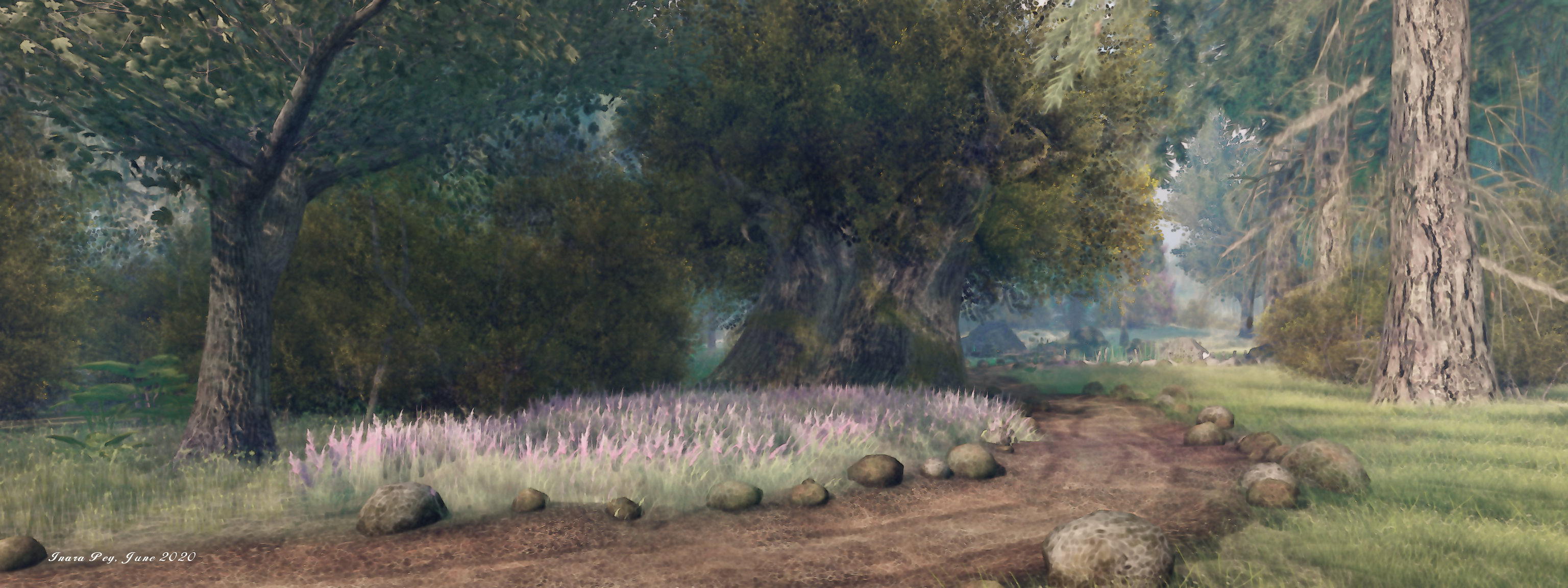
Zakk Lusch recently invited us to pay a visit to Cascadia, a Homestead region he has designed with the assistance of Lilly Noel and Jimmeh Obolensky. The name appears to be taken from the Cascadia bioregion, a theoretical region / country that, were it to come into existence, would extend down through British Columbia, Washington state and Oregon, and inland potentially as far as Utah, although more modest proposals limit it to the the Cascade Mountains.

In particular, this means the bioregion follows the line of the US / Canadian Pacific Northwest coastline, and it is in the spirit of this coastline that the region has been modelled. It offers the suggestion of a coastal headland backed by high mountains, a place where the local highway briefly winds between the two maws of tunnels to offer an expansive view of the northern Pacific.

Cascadia, June 2020

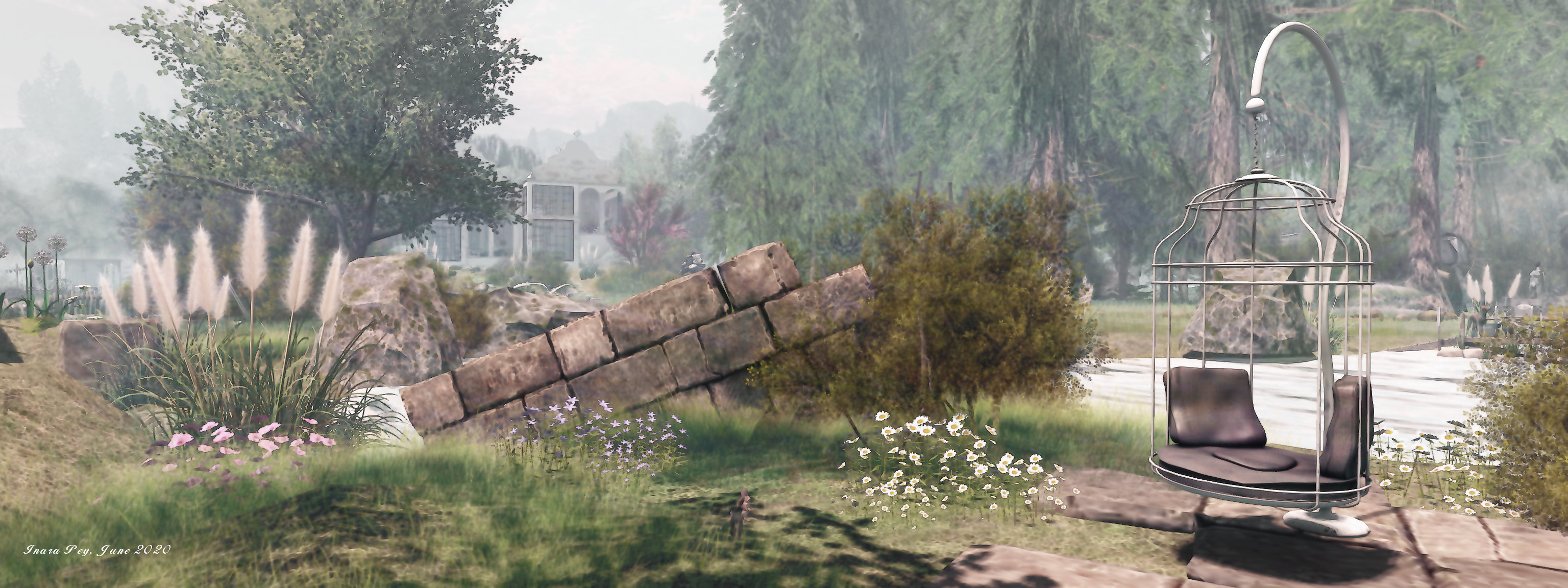
One of the first things to note in general about the region is that it is in part residential, with three private homes located on it. However – and I assume this is a genuine comment – the note card that is delivered to visitors at the landing point states, “While all of the homes on the sim are indeed occupied by Residents, we strongly encourage you to enter these homes and disturb the occupants!”

That said, given the three homes do not intrude into the public areas of of the region, it is possible to enjoy explorations without having to worry about trespassing into people’s homes.

Cascadia, June 2020

Like the coast on which it is modelled, this is a ruggedly beautiful setting, if the drop from high mountain peaks to foothills is perhaps a little abrupt. The landing point sits to the north-east on a deck build over a cove that cuts its way into the landscape. The deck is part of a cosy roadside area just across the highway from the local motel and gas station. The highway appears to be El Camino Real (The Royal Road) – otherwise known as Route 101, suggesting the setting is towards the northern end of the American stretch of the Cascades.

Running out from one of the two tunnels mentioned above, the road points south to pass between the landing point and the motel before making a hard turn to point westwards, passing over a bridge that spans the mouth of the landing point’s cove. In this, the highway offers the best route of initial exploration, although once across it, further paths of exploration open up.

Cascadia, June 2020

One of these routes is a gravel track that offers a way along the south-eastern headland to one of the private homes. The latter might easily be mistaken for a café given the OPEN sign hanging alongside the door, but the furnishing and washing hanging on the line outside confirm it is a residence, a small and rough beach bordering it on two sides. Just before the path along the headland reaches it, it passes steps that descend down to a ribbon of beach that points westward, under a line of low cliffs that also see the continuance of a branch of the gravel path above which in turn sits the second of the region’s homes.

This second house sits on a square of rock between gravel and highway, trailing a tail behind it that narrows to a point where stone steps connect path and highway, a wooden bridge alongside crossing the waters to where the third house sits on its own island, offering an impressive view back across the region.

Cascadia, June 2020

Cascadia is a photogenic, natural region that is given added life by the inclusion of static figures, each of which has been perfectly placed: the tourists pausing in their journey to take in the view, the cyclist taking a break from a ride along the coast, shoppers and storekeepers in the little roadside area, and so on.

There are also touches of humour to be found within the region – the advert for a shady lawyer, for example – together with numerous places to sit, some more obvious that others. For the latter, be sure to follow the signs for the woodland walks; one might lead you to a camp site being watched over by an unexpected visitor!

Cascadia, June 2020

An engaging and considered design well worth the time needed to explore and appreciate it. Our thanks to Zakk for the invitation, an apologies for taking a while to accept it.

SLurl Details

  • Cascadia (whisperwoods, rated Moderate)

A summer’s island in Second Life

Conall-Vika, June 2020 – click any image for full size

Conall-Vika is the name given to a Homestead region designed by Second Life partners Madflex and Trin Adasia we were directed towards by Shawn Shakespeare, who is always the expert locator of regions to explore.

The name, according to region’s creators, is derived from the Celtic for “strong wolf” – Conall, as in Conall Cernach, the hero of the Ulaid in the Ulster Cycle of Irish mythology – and “Vika”, which they give as “from the watercourse”.

Conall-Vika, June 2020

It’s certainly true that water plays an important  part in the formation of the region: it sits as a lowland island that at first looks might be taken for a broad inlet that cuts its way into coastal hills and eroded the island’s shores into their distinctive shape.

The landing point sits to the north-east of the island, atop its one highland area: a flat-topped mesa of sheer-sided rock crowned by fir trees, course grass and the remnants of an ancient villa. The latter is apparently long-deserted, lavender plants encroaching into the walls and across the fading wood of a terrace even as the branches of a tree within that terrace are starting to apply their own pressure on the surrounding walls. 

Conall-Vika, June 2020

A single path winds down to the lowlands to join with a lone track that snakes outwards across the island. It offers a route around the region that gently meanders from point of interest to point of interest, offering a perfect means to explore and discover. Many of these form places to sit or pose, most with options for individuals or couples and range from a simple blanket under a parasol through a tricycle built for two, to blanket-draped hideaways, cosy summer houses and beach-side loungers.

Towards the centre of the island the track arcs past a second house. This is a split-level affair with whitewashed walls suggestive of some age. Comfortably furnished, it has a western terrace that looks down over ground that rolls gently down to the island’s ribbon of beach and gives a view out over the waters as they reach into the inlet through a narrow neck formed by off-region hills and another island.

Conall-Vika, June 2020

The tall north side windows of the house present a further enticing look, this one over the bay that cuts it way to the heart of the region. True, aged willow trees drop their branches across the vista in a green curtain that partially obscures the view, but, what can be seen encourages investigation. Doing so reveals they bay is perhaps one of freshwater rather than salt: reeds grow around the bank, whilst swans and ducks swim on the water.

The presence of ducks, swans and reeds transform the setting from the suggestion of it lying on the coast somewhere to one sitting towards one end of a great freshwater lake surrounded by hills. Swans that can be found elsewhere on the water or nestling inland further add to this feeling, whilst the northern end of the island’s bay is occupied by a wooden pier and deck against which a sailing boat is moored. The presence of the latter encourages explorers to walk the grassy tongue that lick west and north around the bay to reach the deck and the loungers on its back.

Conall-Vika, June 2020

All of this only scratches the surface of the region, despite the apparent open nature of the island, there is a lot to appreciate. For example, sheep graze in a meadow with fencing that have seen better days – a fact attested to by the presence of more sheep further afield, enjoying the grass in the lee of the landing point plateau. Art elements are also awaiting discovery, as are some ancient ruins and a little coffee house.

With all that is going on in the physical world due to the SARS-CoV-2 pandemic,  Conall-Vika is another in-world settings that offers a sense of the the outdoors and a relief from being cooped-up inside the house all day. Plus, with all the excitement of SL17B going on through the rest of June, it may also give the opportunity for people to catch their virtual breath. Oh, and the wolves? They are on the island as well – but you will have to keep an eye out for them if you want to find them 🙂 .

Conall-Vika, June 2020

SLurl Details

A rugged retreat in Second Life

PhotoStudio Purple Cows, June 2020 – click any image for full size

Annie Brightstar, who curates Second Life destinations through Scoop It and various social media, poked me via IM to the fact the noted photographer Skip Staheli has opened his personal Homestead region, PhotoStudio Purple Cows, to public visits, and suggested I go have a look.

The region’s design is by Busta (BadboyHi), who is responsible for a number of region designs Caitlyn and I have enjoyed visiting (and in my case, writing about) in that past; a fact that further encouraged me to take a hop across and visit sooner rather than later. And I have to say, his work here is impressive.

PhotoStudio Purple Cows, June 2020

The region forms a rugged, temperate island marked by an impressive spine of an undulating, rocky hill that winds from the north-west to both the south-wast and south-east in and extended “Y”. Relatively narrow, the hill nevertheless appears to contain an high-level aquifer, as waterfalls tumble from its many flanks to both form pools at its base and outflow channels that extend to the surrounding sea, breaking-up the shingle and muddy lowlands.

It’s an entirely natural setting – perhaps the best Busta has produced to date. The central hill is beautifully constructed, rising from natural footings to highest peak, the paths running it it from the lowlands all looking to have been created by the processes of wind and water erosion rather than carrying an appearance of having been purposefully designed. Similarly, the blending of mesh land forms with region terrain is exquisitely done, further enhancing the depth of the setting.

PhotoStudio Purple Cows, June 2020

All of this serves to give the region a feeling of being almost literally transposed from the physical world to the virtual, offering visitors with the sense that they really are in a wilderness location – perhaps somewhere deep within the mountains of North America of just off part of it’s more remote coastline.

It’s a sense of wilderness that’s enhanced by the fact only two man-made structures are on the island. To the north lies a Japanese-style cabin sitting on one of the broad channels of water flowing outwards from the central hill and formed by a horseshoe of waterfalls. The cabin sits as the kind of retreat many of us would love to have; one with a outstanding morning-time view, with places close to hand – just across the water in fact – to sit and contemplate. Eastern influences are strong around the cabin, but in fact it is not a home; within it sits a small café and the suggestion of a studio space.

PhotoStudio Purple Cows, June 2020

The cabin sits in the lee of the hill’s north-west arm, a steep cliff rising just behind it. Follow the base of this shoulder of rock, and you’ll find a path that winds up it and along the rising edge of the cliffs to where stone steps point the way to the second wooden structure, this one home to a bakery and small gallery space. It sits at the summit of the island’s central hill and upon a substantial deck that can be reached by two additional paths up from the lowlands. The deck extends out of the one of the island’s waterfalls to present a stunning view down to the cabin below.

As well following the paths up to the island’s summit, it is possible to circumnavigate the setting, keeping entirely to the lowlands. Bridges connect the shingle beaches where water flows out from the falls, the route rising here and there to pass over rocky feet as they extend to the coast. Doing so will reveal the various routes to the more elevated parts of the island and also bring some of the hidden / smaller details of the region into focus.

PhotoStudio Purple Cows, June 2020

These details are many and varied – and sometimes easy to miss. A few of the more obvious are the the multiple locations where visitors can sit. These range from chairs and converted pallets  to tyre swings and blankets at the end of piers. There’s also wildlife to be found here, but some of it may not be easy to find (hint: keep an eye out for the local perambulating frogs).

A thoroughly captivating region, perfect in its design and execution, PhotoStudio Purple Cows is not one to miss while it remains open to the public.

PhotoStudio Purple Cows, June 2020

SLurl Details

A voyage to Africa in Second Life

Jambo! A Voyage to Africa, May 2020 – click any image for full size

Update, August 2020: Jambo! A Voyage to Africa has been superseded by Light of the Desert. See: A Light of the Desert in Second Life.

Jambo! A Voyage to Africa is a homestead region design by Camila Runo that offers visitors – as its name suggests – a taste of Africa – most likely East Africa, given the use of Swahili; possibly Kenya or Tanzania given the coastal aspects (although admittedly, the setting could be somewhere on the coast of Lake Victoria.

A mix of savannah, woods and wetland forest, the region is rich in wildlife – monkeys, elephants, giraffe, water buffalo, gazelle, ostrich, meerkat, crocodile, lion, and hyena, together with vultures an eagle circles overhead.

Jambo! A Voyage to Africa, May 2020 – click any image for full size

The region is set to to give a good feeling of space, with a number of buildings to be found throughout. These start with what might be a Victorian era safari camp, featuring as it does a proper bed, a large dresser and even a gramophone player, sitting alongside the landing point. Just up the trail from this is a small village – albeit suggestive of one set out for the tourist trade rather than being a working place of habitation.

Jambo! A Voyage to Africa, May 2020

A broad river cuts the region in two. It is spanned by a pair of bridges to the south, while a pier with a rowing boat rezzer close to the village offers the means to cross there or explore the location by water.

It is across the the river that majority of the wildlife can be found, together with a private home  – clearly fenced of to help prevent trespass. Follow the land south on this side of the region and it will eventually lead to a large, solid building, bearing a sign that fans of American ’60s TV series might find familiar  – although there was no cross-eyed lion to be found within; just another big cat undergoing treatment.

Jambo! A Voyage to Africa, May 2020

Exploring the region on foot or – if you have one – a wearable horse – is an easy, pleasant journey, while the animals offer multiple opportunities for photography. Thus time passes easily in the region whilst seeking out opportunities for photography, although the hint of tourism in the village and the presence of the bygone era camp site give a subtle depth to the region, a reminder of Africa’s past exploitation. Fortunately, the only hunting  that can be carried out here is with the camera.

Jambo! A Voyage to Africa is a place that speaks for itself; the default environment catches it towards the end of the day, and the local sound scape supports this time of day. For the keen-eyed, there are a couple of minor anachronisms: a north American bald eagle substitutes for an African fish eagle, while a jaguar similarly substitutes for a leopard in the veterinary centre – but these are more down to the availability of wildlife in-world or on the Marketplace than anything else, and they don’t look glaringly out-of-place.

Jambo! A Voyage to Africa, May 2020

So, if wildlife photography is something you fancy or you just want a walk over the savannah, then make a point to hop over and explore – I’ll just say asante, kwaheri! (at least for now!).

With thanks to Shawn for the landmark.

SLurl Details

A Dream Village in Second Life

**[Dream]** Village, June 2020 – click any image for full size
I received a couple of suggestions from MorganaCarter and Shawn Shakespeare that we should pay a visit to Dolceluna Myoo’s Homestead region **[Dream]** Village. So off we hopped to have a look around, and found it a thoroughly delightfully visit.

The first thing to note about the region is not to let the “Village” of the title fool you; whilst buildings are to be found here, this is not in any way a village style environment; rather it is a open rural space, the buildings scattered across it with plenty of space between them to suggest an untamed place, perhaps sitting on the edge of a more developed location.

**[Dream]** Village, May 2020
The landing point sits to the south, close to a tram line that offers the suggestion that this is an end-of-the-line destination even if the region is surrounded by water. Across the tracks from the terminus is an outdoor events space alongside an old shack. From here, opportunities to explore run in multiple directions, or visitors can opt to hang out and dance on the deck.

**[Dream]** Village, May 2020
Off to the east is the first of the island’s cabins, reached by passing some of the island’s wildlife – bears and deer with seagulls flapping overhead. This is a cosy, aged placed with a makeshift terrace, and a Bohemian interior that’s inviting enough to make one of the region’s cats feel like it is missing out on the comfort, although the geese enjoying the yard outside might disagree; to them the tub of water is far more interesting!

**[Dream]** Village, May 2020
Two large bodies of water cut into the landscape from the east and west, such that the bulk of the low-lying land forms an uppercase “i” in shape.  A further single-storey sits house to the north, a small summer cabin close by. Both are again furnished and offer plenty of opportunities for photography and / or sitting with friends. Horses graze close to the summer house, offering a further reason to tarry here.

More places to sit and pass the time can be found dotted around the setting: chairs and camp sites, swings strung from the boughs of trees, an offshore deck and around the vehicles scattered across the region, such as the old VW camper wagon. For those who fancy something a little different, a hot air balloon sits over  the eastern bay.

**[Dream]** Village, May 2020
There’s a richness of detail to the setting that further brings it to life. As well as wildlife and horses mentioned above, sheep can also be found grazing in places, whilst chickens share the island with the geese. Cats are also much in evidence, some of who form an appreciative audience for one of the poses offered in the region (those wishing to use their pose systems or props van join the local group for rezzing rights).

Ideally suited to a range of environmental settings and with a lot of subtle touches and plenty of details, **[Dream]** Village makes for a visually engaging and restful visit, rich in opportunities for photography and for simple appreciating the scene.

**[Dream]** Village, May 2020

SLurl Details

Another touch of Scotland in Second Life

Auld Lang Syne, June 2020 – click any image for full size

The highlands and islands of Scotland are proving a popular inspiration for Second Life region designers – and rightly so; there is a deep beauty to their rolling hills and high peaks that invites the imagination and leaves the heart filled with a yearning to explore. As such, we’ve visited a number of Scottish themed locations over the last few years, but this is the first time I’ve been able to write about Elo (WeeWangle Wumpkins) Scottish inspired settings.

The latest iteration of her work – Auld Lang Syne – opened recently, and it offers a mix of the rugged abruptness of the Scottish highlands mixed with a strong sense of age within the buildings to be found scattered around it, together with a healthy dose of mystery with a fitting dash of humour.

Auld Lang Syne, June 2020

Admittedly, getting around on foot isn’t easy in places: the island rises sharply from the surrounding sea, and many of the slopes look like they would need a lot of scrambling to get up and down – just as many of the glacier-cut slopes of Scotland’s north may require the assistance of hands when clambering up them and a certain caution in getting down least one feet end up running away beneath one.

This steepness of setting may not at first be obvious from the landing point, which sits on the island’s highest rise within an ancient but intact fortification (Pupito Helstein’s popular Runestone Castle) – just an easy walk away is a group of standing stones inspired by the Neolithic Callanish Stones, located on the west coast of Lewis in the Outer Hebrides.  However, descend the slope from the fortification to the ruins of a medieval chapels and its surrounding graveyard, and you’ll immediately get a feel for the region’s natural ruggedness.

Auld Lang Syne, June 2020

Which is not to say it is all hard work is getting around; here and there are paths that make for easier descent to the coastal areas, one of which is just in the lee of the hilly shoulder on which the stand stones sit. It leads to an extensive coastal beach that faces south and offers and gentle sandy walk east and then north, passing hints of the more recent history of the place: the wreck of a fishing boat, the remains of a broken aeroplane engine – presumably all that remains of a past crash -, an aged anchor and the carcass of an old boat.

To the east, the path along the beach is almost blocked by the waters flowing out from a deep gorge. Fortunately, fallen trunks have been joined to offer a way over the water, a heron standing on their backs like as if awaiting payment of a toll in order to allow visitors to proceed.  Beyond the bridge, more tales of past life can be found, together with some of the island’s current inhabitants, a number of whom appear to have partaken of a wee dip in the sea and are now following another of the trails back up to their hillside home.

Auld Lang Syne, June 2020

One of two towers that rise above the island’s rolling hills watches over these “locals”. Broken and holed, it appears to be a disused water tower, rather than part of any castle or fortress, although a owl is now acting as a look-out, keeping watch from the broken drum of its upper reaches. The view back across the island from this tower reveals the landing point on its high hill, whilst below and to one side, the ruins of what might have been an old manor house can be seen, nestled in secret on a north facing shelf of rock overlooking the beach, sheltered from the rest of the island by a rocky upthrust.

Around to the west, and sheltering below the castle’s hill, is another old ruin, similar in nature to that in the north, and now home to a wonderful garden that positively invites visitors to stay within it. The old structure and garden are in turn watched over by the island’s second tower, also the worse for wear as it sits on a rectangular promontory in the island’s south-west corner.

Auld Lang Syne, June 2020

In between these “main” points of interest are others awaiting discovery that add further depth to the setting and increase the sense of realism to the island. As such, taking the time to wander on foot – particularly in circumnavigating the coast whilst keeping an eye on the slopes above – is recommended. However, for those so inclined, the castle hall forming the landing point has a teleport board that can be used to hop to those main points of interest. The second hall of the castle, meanwhile offers a little galley of photos taken around the region, whilst its flat roof provides a view over the island and places to sit.

All in all, a delightful setting, with plenty of detail and with touches that encourage a smile.

Auld Lang Syne, June 2020

SLurl Details