Studland Bay, March 2020 – click any image for full size
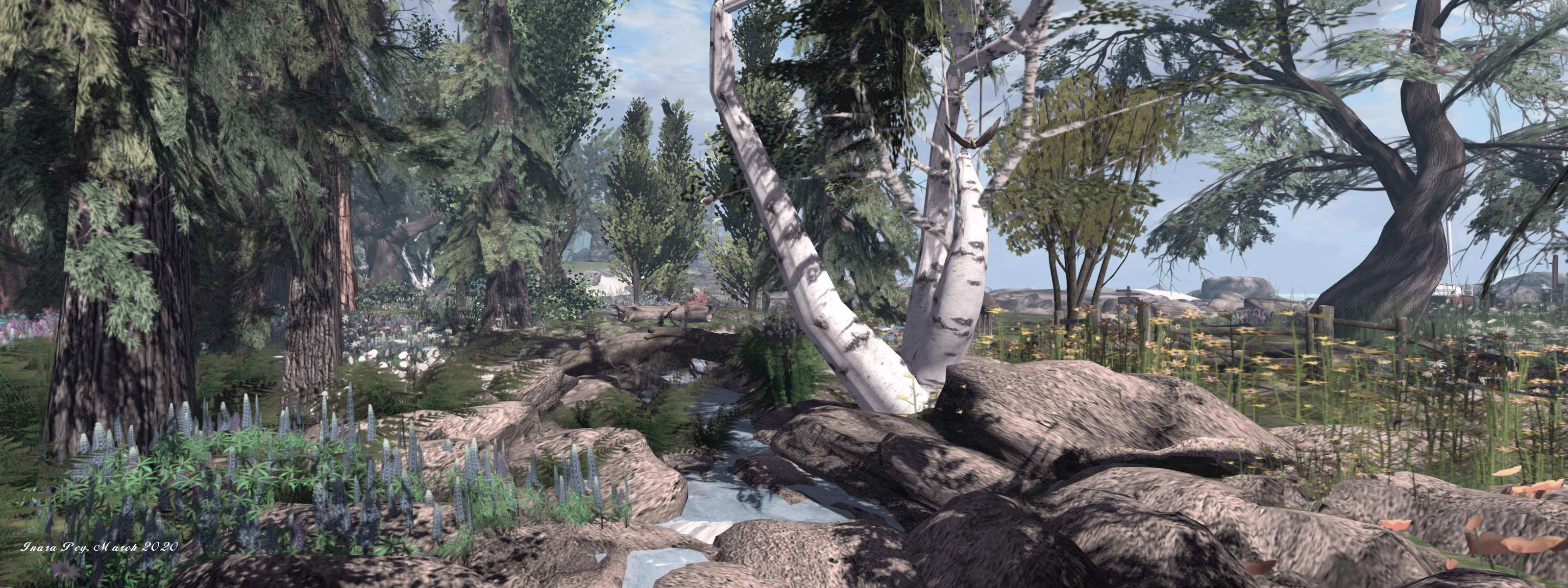
We first visited Studland Bay earlier in the year. At the time the region may have been under redesign, as it was primarily a snowy island, a little hilly in places, and with a few trees. A dirt track ran around the island, a trail for a team of horses and their carriage to follow, but there was little else to be found.
Since then, this Homestead region, designed by Eliza Quixote, has been enhanced to offer – at least at the time of our most recent visit in mid-March – it offers a pastoral setting still held by winter, making it an ideal visit for those who might otherwise be missing the allure of snow.
Studland Bay, March 2020
The landing point is located close to the island’s lone house, a be-porched farmhouse with barns close by and a frozen pond behind. The house is cosily furnished and offers an attractive break from the snowbound landscape, should the latter get to be too much (the house doesn’t appear to be a private residence). It also includes some highly acceptable rules for the use of the porch.
The most obvious way to explore the region is to follow the track. This loops its way around the core of the island, sometimes branching, including to find its way through one of the barns. It offers a comprehensive routine around the farmlands, the path well-rutted by the passage of the cart with its team and by the tractors available for farm use.
Studland Bay, March 2020
The fields here are mostly devoid of fencing, adding to the feel of openness in which the local cattle can roam in search of grass on which to graze – the snow being of a depth where the grass is not too heavily covered. Should it turn out that the snow falls again, there is plenty of hay that can be spread as required. The one fence on the island serves to ring a group of sheep, who similarly graze through the snow, and which are watched over by an eager collie.
The walks along the tracks will also reveal the surrounding regions in the estate, however, while these may appear inviting, the majority appear to be private, so be wary about being tempted to hop over an take a look.
Studland Bay, March 2020
Easy on the eye, with the opportunity to ride a horse-drawn carriage and plenty of places amenable to photography and with a easy, well-suited sound scape, Studland Bay makes for a restful, easy visit.
Finian’s Dream, March 2020 – click any image for full size
Finian’s Dream has been a destination that’s been on our list since the region officially opened; in fact it is one that has given rise to a few recommendations coming my way in the time since (thank you Miro, et al), with the only reason for a delay in dropping in is to allow the initial rush of visitors to be over, so we can creep around and peek at things without getting in the way of others too much.
Designed by Noralie78 of Lost Unicorn Forest fame (read here for more), the region’s description is perfectly offered by her through an introductory note card that can be obtained at the landing point:
Welcome to Finian’s Dream! This beautiful land is in celebration of old Celtic Ireland with a touch of magic 🙂 Ireland is known for its many mystical secrets of the forest…after all, that’s where fairies came from! Walk through the deep and magical woods, you might just make some discoveries along the way. Stop by the pub and allow Donngal to make you a drink while you watch Rowan perform her Irish dance (no she never gets tired :P).
Finian’s Dream, March 2020
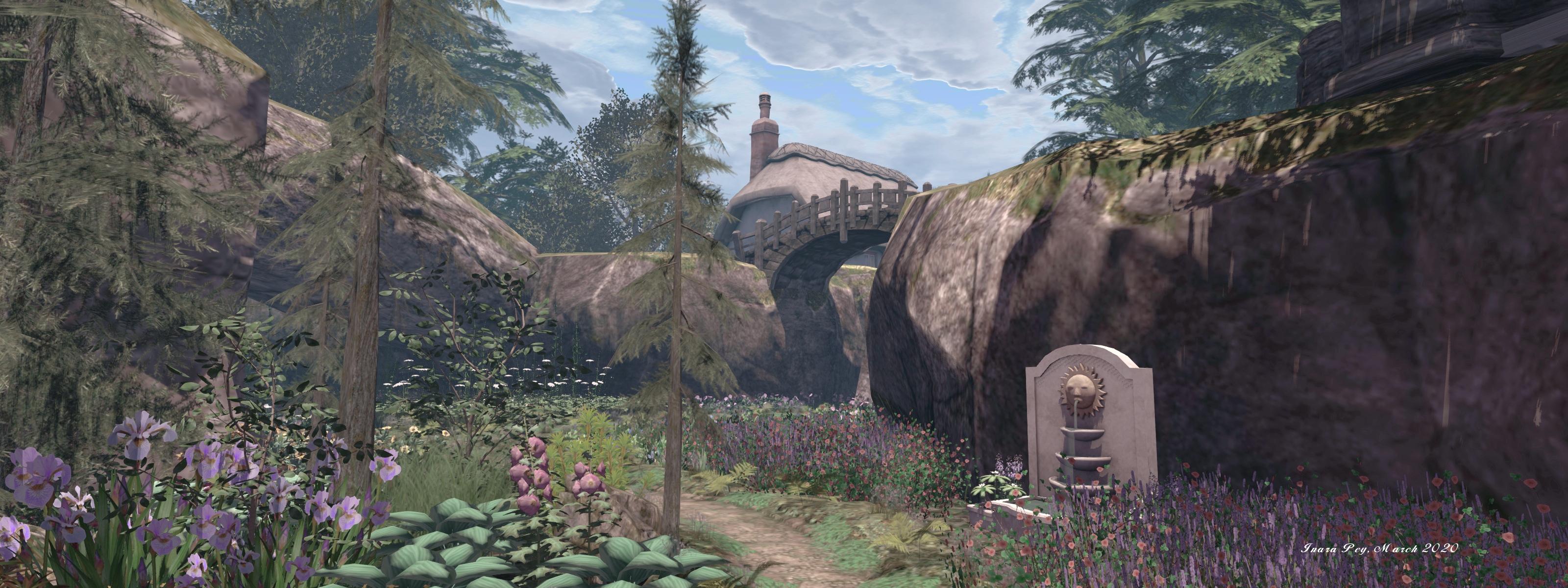
This is a place that harks back to a time when Ireland’s many forests were united to cover much of the land; a place where Ireland’s legends and myths may well have been born. wreathed in mist and caught in a perpetual dusk. In this realm, awaiting discovery, is so much.
From the landing point, the forest, deep in shadow beckons; a place where tiny fairies flit and fly. Statues and glades with stone circles, the air within them cut by slanting Moonlight, await along natural trails a paths set wide between broad tree trunks that hold aloft the covering blanket of branches and leaves.
Finian’s Dream, March 2020
A stream cuts through the forest with logs, either fallen or felled, providing crossing points over it, pointing the way to where a rutted cart track skirts the woodlands. Follow this in one direction, and it leads the way to where stone steps climb the region’s uplands, in the other it offers the way to open farmlands presided over a homely cottage and a lone windmill. Here the land is cut neatly by dry stone walls, home to sheep and cattle.
Above the farm and the canopy of trees, the highlands form a stepped plateau, home to a stone castle that commands the land and those surrounding it. The Irish tricolour hangs above the castle’s portcullis, casting a more recent time to the setting (the flag was a gift to Ireland in 1848, but not officially adopted until the early 20th century), which makes it a slight anachronism given the sense of age and history invoked by the rest of the region.
Finian’s Dream, March 2020
Within the castle can be found a marvellous display of CybeleMoon’s fabulous digital art, which is keeping with the setting, echoing as it does the rich sense of history and legend evoked by the design. Also to be found with the region are three story givers that relate famous Irish legends as narrated by SL resident Sukibombuki Resident.
With the heavy mists, the hidden farm beyond the woods, the cottage in the forest and the twilight sky, its not hard to imagine this is some form of Irish Brigadoon – a place cut off from the rest of the world, filled with its own mystery that, rather than appearing once a century, can only be found by wandering deep into the older IrishfForests and following the path that brings you to this mystical, magical place.
Finians Dream, March 2020
Beautifully conceived and executed, Finian’s Dream is a place that is gorgeous to witness, lovingly put together by the hands and eyes that make Lost Unicorn such a joy to visit.
The Getaway – Nutmeg, March 2020 – click any image for full size
The Getaway – Nutmeg is a homestead region designed by Jacky Macpherson, and towards which we were steered by Shawn Shakespeare.
It’s a wonderfully simple design that is delightful in its attractive minimalism; the kind of place where description is superfluous, simply because its allure is entirely self-evident on arrival.
The Getaway – Nutmeg, March 2020
Two islands, split by a narrow, meandering channel and with shorelines partially formed by low-lying rocks, gently rise out of the surrounding waters. One rises just a few metres above the misty seas, the other somewhat – but not much – higher, thanks to its single, humped hill. Simple plank bridges cross the channel between them, as if stapling them together in an attempt to keep them from going their separate ways as they drift on the tide.
The Getaway – Nutmeg, March 2020
The larger of the two islands is home to the landing point and a single, open-plan cabin with deep-set verandahs. Cosily furnished and open to the public, the cabin has a fence for its neighbour, one that runs across the island as if cutting it into two and keeping the cabin separated from the only other man-made structure of significant substance to be found here: a sun-faded barn that is apparently home to a flea market, and which is also open to public visits, despite the fence.
The landing point sits between two fences that run – for a short distance at least – north-to-south, pointing the way both towards the cabin and to the northern headland over which gulls wheel. A similar pair of fences curl in part around the hill of the second island, marking a routine around its northern flank, while the hill itself is crowned by a sunken tree that raises its boughs in scrub-like abandonment, and a comfortable looking hammock.
The Getaway – Nutmeg, March 2020
Covered in the coarse hair of wild grass and studded with silver birch and a few mountain pine, The Getaway – Nutmeg sits under a windlight sky and over a white sea that are both perfect for photography – as is the setting as a whole. Exploring is easy on the eye, as is the subtle richness of detail, with lots of little touches awaiting discovery.
But as I noted, lengthy descriptions of the region are superfluous, it speaks loudly, clearly and attractively for itself, making a visit more than worth the time taken to drop in and explore.
Ubay Island, March 2020 – click any image for full size
In October 2013, a 7.2-magnitude earthquake struck the province of Bohol, Philippines, inducing about 1m land subsidence to some of its small island communities. Now, the islands of Batasan, Pangapasan, Ubay and Bilangbilangan of the Municipality of Tubigon experience partial or complete flooding even during normal spring tides. Coming face-to-face with a hundred years’ worth of sea level rise, the island communities show that they are far more resilient than we think.
This is the introduction to Racing the King Tide, a film and website looking at the impact of the 2013 Philippines earthquake that was centred on the island district of Bohol had on the people and islands close to its epicentre. One of these islands – perhaps the most deeply affect of them all – is tiny Ubay, which is the central inspiration for Serene Footman’s latest region design in Second Life, and which opened to the public on March 3rd.
Called, appropriately enough, Ubay Island, the setting offers a marvellous reproduction of little Ubay – which is less than 4 acres in size – perhaps as seen in the the time period immediately after the earthquake had struck the region. As is always his way, Serene has provided a comprehensive blog post to accompany the build, and I cannot recommend enough that it should be read alongside any visit to Ubay in-world, as it really puts the build into perspective. Through his writing, Serene provides not only a lens through which to view the build, but also wider context on on the earthquake, its impact on the peoples of Ubay Batasan, Pangapasan and Bilangbilangan.
Ubay Island, March 2020
The build presents Ubay as it appears for around 130-140 days a year: flooded to a typical depth of some 45cm (1.5 ft) – although tidal ranges can make the actual waters deeper. The flooding is a combined result of both rising sea level de to climate change – and which ultimately threaten Ubay’s future – and the fact that the 2013 ‘quake saw a mean decrease in elevation of a metre (3ft) within the area where Ubay is located (an collapse that also gave rise to The Great Wall of Bohol on Bohol island itself), leaving the island’s maximum elevation when dry at just 2.32 m (7.2 ft) above the surrounding sea level.
Under the default windlight the water is a dirty, brackish grey / brown – a reminder, perhaps that flood waters can carry with them dirt, mud, animal manure and human wastes which can be hazardous to health – with wooden walk ways partially winding through the village streets in an effort to keep passing feet dry. In this, the setting has the feel of depicting Ubay not long after the earthquake struck; more recently, much has been done (starting with an imitative by the islanders themselves before they received external support), to raise the village footpaths above the average level of the flood waters.
Ubay,Island, March 2020
The landing point sits within the local school playground, a location which is both touching and somewhat ironic. Touching, as Serene has captured the graffiti marking one of the playground walls that reminds us of the lives the adults and children of the island face: This Is Where We Play. The irony is that on the actual island of Ubay, the playground was supposed to be the evacuation assembly point should the island be at risk of flooding – but in 2013, it was one of the first places to be submerged.
You might think that given the state of the island, it would have been long deserted – and you’d be wrong. Despite the earthquake, despite the continued and very real threat of rising sea levels as a result of climate change, the people of Ubay steadfastly hold on to their homes and way of life, up to and including the annual threat of typhoons wiping the village off the face of the planet.
Ubay Island, March 2020 (as it might appear under a brighter sky and the invasion of sea water)
This might sound like a case of local hubris, but it’s not. With some 74% of the population living below the national poverty line even before the 2013 earthquake, there is simply nowhere else in the Philippines where the peoples of Ubay and its neighbours can survive. This was proven in the period following the 2013 ‘quake when the 300-ish Ubay islanders were made to evacuate to the “mainland”, and almost all of them quietly moved back to island as it was the only place they could survive as fisher folk. In doing so, they have given Ubay its ray of hope.
Serene has tried to capture this sense of life as well: fishing boats lie in the waters around the village, chairs are set out on raised “porches”, ribbons festoon some of the village paths, clothes are set out to dry in the sun and breeze even as the waters pass under the lines on which they are hung, and so on. Someone has even enterprisingly set-up a stage for a music concert while boat repair yards are still in business. True, one or two liberties may have been taken (for example, the Racing the Tide website, for example, infers that the half-submerged house that’s included in the build may be at Bilangbilangan Island rather than Ubay), but none of this spoils the setting in any way – rather, they enhance it.
Set as it is under a heavy sky, with its muddied waters and the ruins of buildings pulled down by the earthquake, and its shanty-like corrugated metal walls and roof tops, you might think that Ubay is a bit of a dismal place in SL to visit, but this simply isn’t so. Serene offers something that is once again captivating, poignant and with a depth of story behind it that should not be missed.
Wizardhat Studios, March 2020 – click any image for full size
We’re all familiar with the news of regions that disappear from Second Life – I’ve reported on a few that have announced closure myself. These disappearances can often be high-profile, leading too public upset and, and times, a reason for some pundits to blog about how they are further signs of SL’s “demise”.
What often goes unnoticed, however, are the regions that endure, sitting quietly tucked away, offering a place for people to visit year-on-year, unsullied by time. They remain a constant in the face of change over the passing of time, but can so easily pass notice by bloggers as we rush to seek the latest or new region design or setting.
Wizardhat Studios, March 2020
Take Wizardhat Studios, for example. I made my first visit to it almost seven-and-a-half years ago, in October 2012 (see: Wizardhat: dance, explore, contemplate, admire). At that point in time the region was already entering its fourth year, and it became a place I tended to jump back to semi-frequently over the next few years – although I confess that other than that one 2012 blog post, I’ve never actually written about it again in detail.
This fact had been playing on my mind over the course of the last week or so, a nagging feeling that as it’s been about 4 years since I last dropped, I should pop over and take another look. It’s a thought that was reinforced when reader and friend Miro Collas poked me via Twitter about the region. So, off I hopped.
Wizardhat Studios, March 2020
Designed by Karencreek Melson as the home of artist Wizardhat Mornington, the region is an atmospheric mix of reality, and fantasy, making excellent use of region surrounds and off-sim elements to create a great sense of depth. The default Windlight is perhaps a little bleak – I again found myself flicking to one of my preferred custom presets, but that’s about the only “complaint” I have with the region.
This is a place of coastal castles – one a home to Wizardhat’s photography and art, the other set as a home (but open to the public), where rough-faced cliffs climb to one side, water tumbling from them in places. This cliffs form a semi-circle enclosing the lowlands, their waterfalls forming streams that split the land with its mix of woods, flowers, and cart tracks, as the waters make their way to the sea.
Wizardhat Studios, March 2020
It’s also a place of whimsy: a steampunkian flying submarine floats alongside one of the castles, its interior perhaps triggering thoughts of Captain Nemo’s Nautilus and its vast undersea voyages. Not far away, polar bears take a moment in the sun, stretched out on the western beach; apparently the benefactors of a lottery win. Other animals roam free in the form of scripted agents, some of whom I recall from past visits, such as Happy Camper, others of which may well be new – or at least, relatively new. They wander about the lowlands and / or frolic in greeting while birds wheel overhead.
The animals are not the only perambulating occupants of the region. As you explore, you may notice that a couple of the trees appear to be locating themselves. Wait long enough, and you’ll see this is precisely the case, as one or another of the pair calmly uproots itself and goes for a wander, both of them again being scripted agents. It’s clear that these arboreal wanders are an accepted part of the landscape, as an owl is content to sit in the boughs of one as it takes to its roots and scurries across the land.
Wizardhat Studios, March 2020
What is particularly attractive with this region is that while it retains almost all of its original looks (for those of us familiar it from past excursions), it is also home to subtle changes that both maintain its look and appeal whilst also in part renewing it and making it worthy of return visits. Take the hillside turret to the north; once it looked out towards a storm that seemed to be approaching, now it faces stern-faced faced mass of rock sitting just off-sim.
Eclectic, rich in detail, with lots of opportunities for exploration, photography and dance, Wizardhat Studios remains an engaging visit, one given the added fact it is a place now into its 13th year in Second Life.
Peacehaven, March 2020 – click any image for full size
It has been just over three years since we last visited Pacehaven, a setting designed by PurrBlaize. At that time Purr had just made the move from a Homestead region to occupying a quarter of a Full region (see Peacehaven – A New Beginning in Second Life and, before it, The serenity of Peacehaven in Second Life). Since hat time, Purr has once more relocated, and gained something of a larger space in which to establish Peacehaven with a new look.
Now occupying almost a 1/2 region, Peacehaven retains all that has made it an attractive visit, whilst also sharing the space with a neighbouring parcel that offers live music and events to create a feeling of even more space. It is once again an environment that demonstrates you don’t need a full region in order to create an expressive place that offers a rich amount of exploration, being almost almost perfectly put together by Purr and her SL partner BluBlaize.
Peacehaven, March 2020
Offering an aspect looking to the west, the setting has a summertime, semi-tropical look as it runs inland from the western ribbon of beach, above which the landing point sits, to form a rugged, uneven and attractive landscape cut by paths, water channels and gorges that slice between and around two central plateaus, gorges and water channel alike spanned by bridges such that while smaller than a region’s full size, Peacehaven has multiple routes of exploration that make it feel as if it occupies an entire region.
Three paths point outward from the landing point and the graystone summer house that sits alongside it. The first runs to the north, the second due east, the third to the south and east. All three actually eventually link up one to another, providing a means to tour the entire setting – although as noted, they are laid out in such a way that they don’t feel as if they are “just” a simple loop. Quite the reverse in fact.
Peacehaven, March 2020
To the north, the first path runs alongside a water channel, passing a squat fort (home to a little rooftop café) and which stands guard over a man-made causeway the extends out over the water to a waiting lighthouse. Two bridges span the water channel, one linking the path to the fort, the second to connect it with another deck that offers moorings for boats. Beyond this, the path reaches a garden pavilion sitting on the north-side beach, crouched next to one of the region’s squat plateaus.
A fence separates the pavilion from the path, but a gate allows access, and rather than being a private space as the fence might suggest, the pavilion forms a small place to hang out, a second path running due south from it to eventually become the southern path back to the landing point. Along the way it branches with a west-pointing route, and also passes under a rocky arch and colourful flowerbeds.
Peacehaven, March 2020
The southern end of this route ends in a set of steps connecting Peacehaven with the neighbouring music venue that is also available for exploration, while an ancient pointed arch indicating the path running back to the landing point. This arch also sits under the shadow of one of the parcel’s plateaus – the larger of the two, in fact – which is home to a cottage that has been a motif throughout the various Peacehaven designs. It can be reached either from a further branch of the west-pointing path, one which gently coils upwards around to sides of the plateau, or the third of the paths available from the landing point, as it passes through the summer house and then climbs up to the cottage by way of stair and tiered garden.
A bridge connects the cottage with the second plateau – the one below which the hangout hides – which is home to a half-circle ruin, another motif from previous Peacehaven builds. This also forms a place to hang out and / or dance while a final path from here snakes down to meet the west path running from the landing point to beach summer house.
Peacehaven, March 2020
All of this barely scratches the appeal of Peacehaven, which remains as much an attractive and photogenic sitting as it ever has been, rich in colour, offering a warm, natural welcome and plenty of opportunities to simply relax and recharge.